

1 Introduction
The Late Palaeozoic thrust-and-fold belts of the Urals and Tian Shan formed as a result of convergence and collision of the Kazakhstan continent with the East Europe (Baltica) craton in the west, and the Tarim, Alay and Turan microcontinents in the south [10,23,25,27]. Two belts meet in the subsurface almost at a right-angle in the region of the Aral Sea and the Syrdarya basin (Fig. 1a), which is broadly covered by Mesozoic and Cenozoic deposits. Though the principal features of the basement were established by drilling and by geophysical data [1,3], details of the structures and history of this region remain enigmatic. The general style of deformation, evolution of the stress field, as well as the timing and geodynamic environments of structural events are generally poorly constrained. In order to address these questions, a structural study was undertaken in one of the few exposed areas in the Ural–Tian Shan junction, namely the Karatau ridge of southern Kazakhstan (Fig. 1).
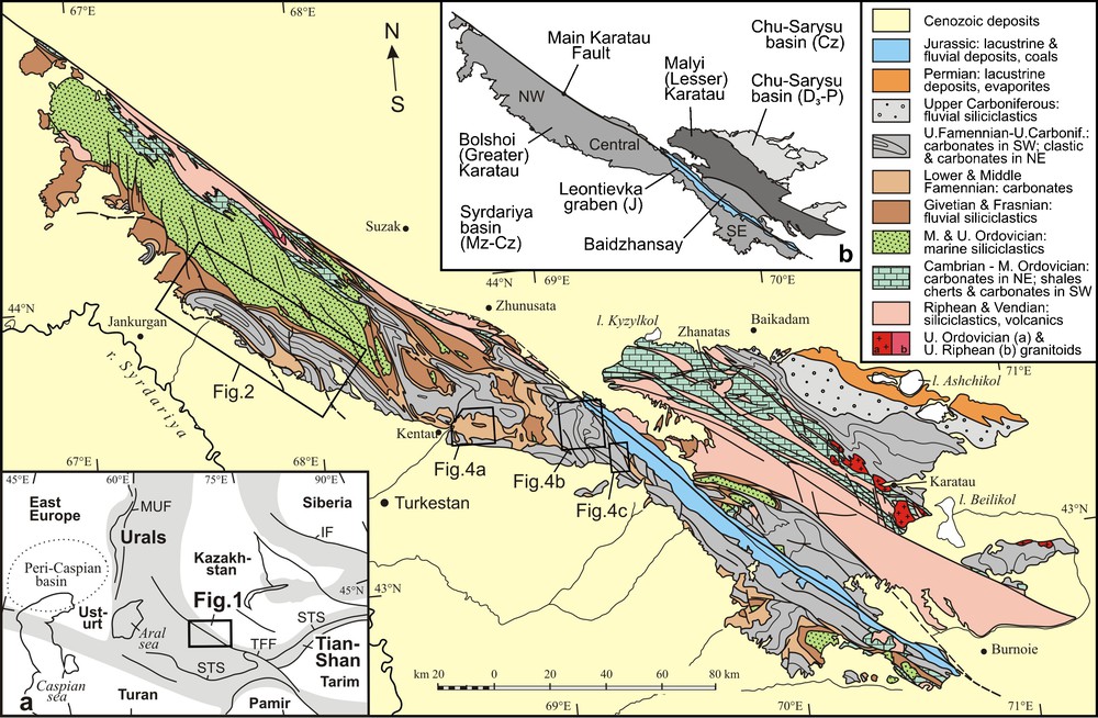
Geological map of the Karatau ridge, modified after Chakabaev [14]. a: sketch map of the Ural–Tian Shan junction. Gray color designates Late Palaeozoic to Early Mesozoic thrust-and-fold belts. TFF: Talas–Ferghana Fault; STS: South Tian Shan Suture; MUF: Main Uralian Fault; IF: Irtysh Fault. b: tectonic setting of the Karatau.
Fig. 1. Carte géologique de la dorsale Karatau (modifiée d’après Chakabaev [14]). a : carte schématique de la jonction Oural–Tien Chan. La couleur grise représente les ceintures de faille et de plis depuis le Paléozoique tardif jusqu’au Mésozoique précoce. TFF : faille Talas–Ferghana ; STS : suture au sud de Tien Chan ; MUF : grande faille de l’Oural ; IF : faille d’Irtych. b : cadre tectonique de la dorsale de Karatau.
2 Geological background
The Karatau ridge is located in the northwestern part of the Tian Shan between the Syrdarya basin in the southwest and the Chu-Sarysu basin in the northeast (Fig. 1a, b). The geological setting of Karatau has been discussed in a number of publications [3,7,15–17] and is only summarized here. The area is divided into two zones: Malyi (Lesser) Karatau in the northeast and Bolshoi (Greater) Karatau in the southwest (Fig. 1b). The Malyi Karatau consists of Neoproterozoic siliciclastic rocks with minor amounts of tuffs, which are interpreted as being indicative of a continental rift setting, together with Early Palaeozoic carbonates, which were deposited within an isolated seamount with shallow marine central parts and deeper marine slopes in the northeast and southwest [15]. The Early Palaeozoic structure of the Malyi Karatau represents a series of northwest-trending thrusts with top-to-the-south-west motion. The thrusts are overprinted by north-west trending folds, which are inclined and overturned to the northeast. The time of deformation is constrained by the Middle Ordovician age of the youngest stratified rocks and a Late Ordovician age (448 ± 4 Ma, Rb–Sr mineral and whole-rock isochron) for a granite pluton [5]. The granites postdate the thrusts and were emplaced synchronously with folds [4]. Bolshoi Karatau consists of shallow marine carbonates and rift-type volcanic rocks of Riphean age, Vendian shales and Early Palaeozoic deep marine carbonates, cherts and siliciclastic turbidites [3]. The widespread occurrence of nonmarine and shallow marine deposits in the Neoproterozoic and Early Palaeozoic, as well as sandstones and conglomerates enriched in quartz, granitoids, felsic metamorphic rocks and feldspar clasts, suggests the presence of Precambrian continental crust within Karatau. Similarities in depositional facies may relate Karatau to the Ishim–Middle Tian Shan (or Ishim–Naryn; Syrdarya) microcontinent, which extends from central Kazakhstan to eastern Kyrgyzstan [8,25].The amalgamation of several microcontinents and island arcs during the Ordovician and Early Silurian led to the formation of the composite continent of Kazakhstan. A continental active margin developed within the eastern part in the central and eastern Kazakhstan (present-day coordinates) around the Junggar–Balkhash area, from the Early Devonian through to the Late Palaeozoic. The western margin was characterized by short-lived subduction systems in the Early and Middle Devonian and during the second half of the Carboniferous [13,19,25,27]. From the Givetian through to the middle of the Carboniferous, the western margin of Kazakhstan evolved in a passive regime. The Bolshoi Karatau, during the Givetian and Frasnian, was dominated by deposition of fluvial and shallow marine siliciclastic rocks, ranging in thickness from tens of meters to 2500 m. From the Early Famennian through to the Middle Bashkirian a carbonate platform developed in the Bolshoi Karartau and up to 3.5–4.5 km of carbonate sediments accumulated during this time. Depositional facies from northeast to southwest change from shallow shelf lagoon, to shelf margin with algae bioherms, to slope turbidites and basin mudstone facies [16,17]. A marine transgression, during the Late Famennian to Visean, led to the formation of an epicontinental sea in the Malyi Karatau and Chu-Sarysu basin, and shallow marine carbonate and siliciclastic facies with some evaporites accumulated there till the middle of the Bashkirian. During the Late Bashkirian through the Permian, the Malyi Karatau represented a transition zone from the orogenic belt in the southwest to the intracontinental Chu-Sarysu basin with fluvial and lacustrine facies in the northeast [3,7,16].
3 Structural assemblages and deformation history
The structural geology of the Bolshoi Karatau was studied in detail during the exploration for lead and zinc in the period from the 1940s to the 1980s, and the resulting models for the deformation processes dominated Russian geosciences for several decades. Two alternative groups of models were developed. One group pointed at high-angle faults, box- and dome-shaped folds with vertical block movements as the main mechanism of deformation [11,21]. The other group argued for major horizontal displacements along strike–slip faults and thrusts, and this point of view was broadly accepted in later publications [3,12,20]. Latest sedimentological studies, however, had demonstrated that the carbonate breccias, which were considered in many places as indicators of thrust faults, in reality represent sedimentary rocks, i.e. mega-breccia debris flows, marine karst or evaporite collapse breccias [16,17], and the existence of numerous thrusts was questioned. Indications for several deformation events were also suggested recently [6,7], but the number of episodes, the kinematics of characteristic structures and stress directions during different phases remained a subject of discussion. We present data, obtained by detailed mapping and structural studies in different parts of Karatau, which help to resolve some of the existing uncertainties.
Three deformational episodes (D1, D2, and D3) can be reconstructed, which occurred from the Late Carboniferous through the Early Mesozoic. D1 structures define the overall tectonic style of the Late Palaeozoic Bolshoi Karatau. They are represented by numerous folds and thrusts with a general NW–SE trend. The folds vary from tight to very open and broadly range in amplitude from tens of metres to a maximum of 15–20 km and up to 50–80 km in length (Figs. 1 and 2). The larger folds occur typically in massive carbonates, which deformed as a single unit up to 4.5 km thick. The smaller folds occur in thinly bedded units and often represent disharmonic structures with respect to larger folds. Commonly, the D1 folds are inclined and overturned to the northeast and their axial planes dip southwest at angles of 60–80° (Fig. 2b). Minor thrusts and reverse faults with top-to-the-northeast motion were widely developed on the limbs of the folds [18,20]. The larger-scale D1 thrusts are rare and limited to the Akuyuk area (Fig. 2) [2,3,7,20]. Stratigraphic separation of these thrusts reaches 4–4.5 km, and horizontal displacements can be estimated from cross sections as being up to 10–15 km in magnitude.

Passive-roof thrust and intercutaneous wedges deformed as the north-west-trending folds in Akuyuk area. 1: Middle and Upper Ordovician sandstones; 2: Givetian and Frasnian redbeds; 3: Lower and Middle Famennian carbonates; 4: Upper Famennian to Lower Visean carbonates; 5: Lower Visean siliciclastic rocks and carbonates; 6: Visean to Lower Bashkirian carbonates; 7: Lower Bashkirian siliciclastic rocks and evaporites; 8: Upper Cretaceous and Palaeogene (K2-Pg); 9: major thrusts (a), second-order faults (b), drilling wells (c). Numbers in circles refer to thrusts: 1: North Akuyuk; 2: South Akuyuk; 3: Maidantal; 4: Kenes; 5: Baktysai; 6: Tambet. Masquer
Passive-roof thrust and intercutaneous wedges deformed as the north-west-trending folds in Akuyuk area. 1: Middle and Upper Ordovician sandstones; 2: Givetian and Frasnian redbeds; 3: Lower and Middle Famennian carbonates; 4: Upper Famennian to Lower Visean carbonates; 5: Lower Visean ... Lire la suite
Fig. 2. Faille à toit passif et coins intercutanés déformés en plis orientés nord-ouest dans la région d’Akuyuk. 1 : grès de l’Ordovicien moyen et supérieur ; 2 : lits rouges givétiens et frasniens ; 3 : carbonates du Famennien inférieur et moyen ; 4: carbonates du Famennien supérieur au Viséen inférieur; 5: roches siliciclastiques et carbonates du Viséen inférieur ; 6 : carbonates du Viséen au Bashkirien inférieur ; 7 : roches siliciclastiques et évaporites du Bashkirien inférieur ; 8 : Crétacé supérieur et Paléogène (K2-Pg) ; 9 : charriages majeurs (a), failles de second ordre (b), puits de forage (c). Les chiffres dans les cercles représentent les failles : 1 : Akujuk Nord ; 2 : Akujuk Sud ; 3 : Maidantal ; 4 : Kenes ; 5 : Baktysaj ; 6 : Tambet. Masquer
Fig. 2. Faille à toit passif et coins intercutanés déformés en plis orientés nord-ouest dans la région d’Akuyuk. 1 : grès de l’Ordovicien moyen et supérieur ; 2 : lits rouges givétiens et frasniens ; 3 : carbonates du Famennien inférieur et moyen ; 4: carbonates ... Lire la suite
Stratigraphical control of major thrusts is illustrated on Fig. 3. Fault preference diagrams [26] permit evaluation of the most common detachment horizons and characterize the positions of the thrusts with respect to layering. The relative fault preference value (Ri) is determined by dividing the mapped length of fault trace in a stratigraphic unit (Li) by the thickness of that unit (Hi) and normalizing each value (Ri%) [26]. The fault preference diagram for the Akuyuk area indicates a single decollement level at the contact of the Givetian and Frasnian siliciclastic rocks with the Famennian carbonates. More precisely, it corresponds to a 10–150 m thick siltstone horizon, the so-called Korpesh formation of Frasnian age, which represents a weak layer between two competent units. The Korpesh formation has a regional extent, and detachments at this level are broadly developed everywhere in the Bolshoi Karatau. During the fold deformation the siltstones were commonly squeezed into the cores of anticlines, where they formed lens-shaped bodies up to 800 m thick and developed complex disharmonic folding, with the best examples in the central Karatau [11,20]. Second-order lithologically controlled decollements in central Karatau also occur at the contact of the Middle Famennian and Upper Famennian rocks, which consist of ductile, thinly bedded and massive competent carbonates, respectively [3,20].
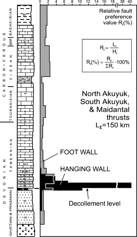
Fault preference diagram for the North Akuyuk, South Akuyuk and Maidantal thrusts. The relative fault preference (RFP) value (Ri) is determined by dividing the mapped length of the fault trace in a stratigraphic unit (Li) by the thickness of that unit (Hi) and normalizing each value (Ri%). RFP values are shown separately for hanging wall and foot wall. Abbreviations on the column refer to mapped units. Note main decollement level at the contact of siliciclastic rocks and carbonates. Masquer
Fault preference diagram for the North Akuyuk, South Akuyuk and Maidantal thrusts. The relative fault preference (RFP) value (Ri) is determined by dividing the mapped length of the fault trace in a stratigraphic unit (Li) by the thickness ... Lire la suite
Fig. 3. Diagramme de préférence de faille pour les charriages de l’Akujuk Nord, de l’Akujuk Sud et de Maidantal. La valeur (Ri) de préférence de faille relative (RFP) est déterminée en divisant la longueur cartée de la trace de la faille dans une unité stratigraphique donnée (Li) par l’épaisseur de cette unité (Hi) et en normalisant chaque valeur (Ri%). Les valeurs de RFP apparaissent séparément pour le compartiment chevauchant et pour le compartiment de base. Les abréviations de la colonne correspondent aux unités cartées. À noter le niveau de décollement principal au contact des roches siliciclastiques et des carbonates. Masquer
Fig. 3. Diagramme de préférence de faille pour les charriages de l’Akujuk Nord, de l’Akujuk Sud et de Maidantal. La valeur (Ri) de préférence de faille relative (RFP) est déterminée en divisant la longueur cartée de la trace de ... Lire la suite
As can be seen, both on the geological map (Fig. 2a) and on the fault preference diagram (Fig. 3) the thrusts are oriented subparallel to bedding in the hanging wall and clearly cut stratification in the foot wall. Such relations imply that thrusts started to form as layer-parallel decollements at the earliest phase of deformation, when the strata remained essentially flat. Subsequently they cut up-section in the cores of anticlines. Further, thrust movement occurred synchronously with folding and led to the destruction of anticlines and deformation of the thrust sheets in synforms.
All thrusts have top-to-the-north east sense of movement, with the only exception being the South Akuyuk thrust (Fig. 2, thrust 2), which has an opposite direction. Detailed mapping showed that the South Akuyuk thrust splits southward from the North Akuyuk–Maidantal thrusts (Fig. 2, thrusts 1 and 3) and represents a conjugate shear with respect to them. The South Akuyuk thrust cut stratification in its foot wall at angles of ≈ 35–50°, and this reflects the original dip angles of the shear, conjugated with a subhorizontal decollement. The Akuyuk syncline, which is bounded by North Akuyuk and South Akuyuk thrusts from the northeast and southwest respectively, represents a passive roof thrust. Wedge-shaped bodies in the South-West of the South Akuyuk thrust acted during the deformation as intercutaneous wedges (Fig. 2b). The conclusion that the Akuyuk passive roof thrust originally comprised a single body with the Maidantal thrust is also supported by similarity of the Famennian and Carboniferous sedimentary facies (mainly shallow marine) in these two units. These are in sharp contrast with coeval deeper marine facies in other thrust sheets in the South-West [17]. The direction of NE 45–50° thrusting was determined at one locality for the Maidantal thrust by drag folds in the thrust zone. The vector is subperpendicular to the strike of the thrust, and this implies that thrust motion essentially had no oblique component.
The north-west-trending folds are also widespread in Precambrian and Early Paleozoic formations in the NW Bolshoi Karatau (Figs. 1, 1b, 5a). These structures were formerly interpreted as Late Ordovician in age [22]. However, similar trends and morphologies with D1 folds and a weak angular unconformity between the Early Palaeozoic and Devonian rocks imply that many of these folds were formed during the Late Palaeozoic and are related to our D1 assemblage. The north-west-trending folds in Famennian, Carboniferous and Permian rocks in the Chu-Sarysu basin (Fig. 1) [7,22] have similar trends to D1 folds but appear to be significantly younger (see below). They may either characterize the latest phase of D1 or, more likely, reflect a separate, local structural episode.

Distribution of characteristic structures and shortening directions during the D1, D2 and D3 events.
Fig. 5. Distribution des structures caractéristiques et des directions de raccourcissement pendant les événements D1, D2 et D3.
D1 thrusts and folds have stable NW–SE trends with minor deviations, which can be explained by later overprints, and indicate general shortening in a NE–SW direction (Fig. 5a). This implies that D1 deformation was neither connected with, nor accompanied by, strike–slip motion along north-west-striking faults, which are subperpendicular to the direction of shortening. The strike–slip motions occurred later, during the D2 and D3 phases.The D2 assemblage unites the north-west-striking left-lateral strike–slip faults, sub-meridional (north-south-trending) folds, and a wide variety of minor structures, which are characterized by shortening in an east-west direction (Fig. 5b). Northwest-striking sinistral strike–slip faults are widespread in the Karatau and in some papers have been defined as the main structural element in the area [20]. They developed independently or reactivated deformed D1 thrusts, both at places where the thrusts are subvertical, e.g., in the central part of the North Akuyuk thrust, or have moderate dip angles e.g., Tambet thrust, southeastern part of the North Akuyuk thrust and others (Fig. 2). High-angle strike–slip faults are accompanied by cleavage zones with a steep S0/S1 lineation (bedding/cleavage intersection). Cleavage zones associated with larger faults such as the Main Karatau Fault may reach up to several kilometres in width and represent belts of dispersed strike–slip motion, but this statement needs more detailed observations to be substantiated.
A left-lateral sense of motion along the north-west-striking faults is shown by slickenside lineations, S-shaped and steeply plunging attendant folds, minor strike–slip duplexes, characteristic terminal curvatures, and offsets of stratigraphic and structural markers [20]. Sinistral separation of the smaller faults range from hundreds of metres to several kilometres; however, larger offset cannot be ruled out for major faults, particularly the Main Karatau Fault.
D2 folds are widely developed in the central and SE Karatau and, to a lesser degree, in the northwest, and in the Baidzhansay area (Figs. 1b; 5b). They are clearly visible both on aerial photographs and on detailed geological maps. The D2 folds commonly represent low angle and open structures with interlimb angles ranging from 120 to 90°. Closed and tight folds are rare. D2 fold axes trend NNE with deviations towards the north and north-east (Fig. 4a–c). At some localities the folds are terminated by north-west-striking strike–slip faults (Fig. 4c) and apparently formed in a transpressional setting between left-lateral strike–slip faults. Overprinting of D1 folds by D2 folds led to the development of dome-and-basin patterns. Dome structures developed at the intersection of anticlines, basins formed at the intersections of synclines, and saddle structures occur at the intersections of synclines and anticlines (Fig. 4). Fig. 4a–c illustrates relations between D1 and D2 folds for different azimuths of trend. The angle between D1 and D2 axes is ≈ 70° and remains stable for all azimuths (Fig. 4, rose diagrams). The latter indicates joint rotation of D1 and D2 folds during the D3 stage.
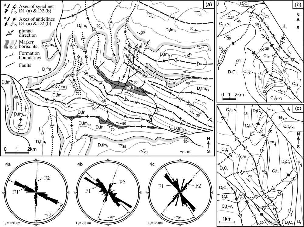
Dome and basin patterns due to overprint of D1 folds by D2 in the Khantaghe (a), Aktas (b) and Odamanbulak (c) areas; see Fig 1 for locations. Rose diagrams show orientation of fold axes. Note stable angle between two trends for different azimuths. Marker horizons: a: siltstones; b: limestone breccies; c: all others (limestones); D: Devonian; C: Carboniferous; J: Jurassic; fr: Frasnian; fm: Famennian; t: Tournaisian; v: Visean. Subscripts 1, 2 and 3 refer to Lower, Middle and Upper. Base maps modified after Abdulin et al. and Bronguleiev [2,11] and unpublished maps of L.V. Belyakov, O.N. Kraev, G.I. Makarychev, G.E. Shinkarev, and E.S. Zorin. Masquer
Dome and basin patterns due to overprint of D1 folds by D2 in the Khantaghe (a), Aktas (b) and Odamanbulak (c) areas; see Fig 1 for locations. Rose diagrams show orientation of fold axes. Note stable angle between two trends ... Lire la suite
Fig. 4. Arrangements en dôme et bassin dus à la surimpression des plis D1 par D2 dans la région de Khantaghe (a), d’Aktas (b) et d’Odamanbulak (c) ; voir la Fig. 1 pour la localisation. Les diagrammes en rosace montrent l’orientation des axes de plis. À noter l’angle stable entre deux orientations d’azimuts différents. Horizons repères : a : siltites ; b : brêches calcaires ; c : toutes autres (calcaires) ; D : Dévonien ; C : Carbonifère ; J : Jurassique ; fr : Frasnien ; fm : Famennien ; t : Tournaisien ; v : Viséen. Les indices 1, 2 et 3 se réfèrent à Inférieur, Moyen et Supérieur. Les documents cartographiques de base sont modifiés d’après Abdulin et al. et Bronguleiev [2,11] et les cartes non publiées sont de L.V. Belyakov, O.N. Kraev, G.I. Makarichev, G.E. Shinkarev et E.S. Zorin. Masquer
Fig. 4. Arrangements en dôme et bassin dus à la surimpression des plis D1 par D2 dans la région de Khantaghe (a), d’Aktas (b) et d’Odamanbulak (c) ; voir la Fig. 1 pour la localisation. Les diagrammes en rosace montrent l’orientation ... Lire la suite
The younger age of D2 relative to D1 is shown by the D1 fold axes curvature at the intersections with D2 folds, and also the D2 strike–slip faults renew and displace D1 thrusts and folds.
D3 structures are represented by north-west-striking right-lateral strike–slip faults, east-west-trending plunging folds, and various smaller-scale structures indicative of north–south-shortening (Fig. 5c). The Main Karatau Fault (Fig. 1b), which is the northern continuation of the Talas-Ferghana dextral strike–slip fault, is the largest element of the D3 assemblage. The accumulative magnitude of dextral motion along the Talas–Ferghana fault from the late Palaeozoic through to the Quaternary reaches a maximum of ≈ 180 km in the central part in the Ferghana ridge and decreases along strike towards the north-west and south-east [12]. Right-lateral separation across the Main Karatau Fault remains uncertain due to lack of displaced markers, but based on the large separation in the south, it can be assumed to be many tens of kilometres. Smaller-scale right-lateral strike–slip faults, with separation of about 2–3 km, commonly reactivated D2 left-lateral strike–slip faults [7]. Both larger and smaller faults are accompanied by right-lateral strike–slip duplexes. Minor wrench zones with north-south-trending en echelon veins, indicative of north-south-shortening, are also broadly developed everywhere in the Bolshoi Karatau.
D3 plunging folds are well demonstrated by the characteristic curvatures of D1 fold axes. Such curvatures were described near the Main Karatau Fault [12] and were also found in the Akuyuk area (Figs. 2a, 5c). In the latter case D1 synclines were deformed into Z-shaped plunging folds with east-west-trending axes (Fig. 2a, lower central part), which implies east-west compression and right-lateral northwestern motion. The larger scale curvatures, which are responsible for rotation of the D1 and D2 structures, are kinematically similar to plunging folds and are also related to the D3 assemblage.
4 Ages of deformation
The time of the main D1 deformation event can be defined as Late Carboniferous, from the middle of the Bashkirian (≈ 315 Ma*1) onwards. Evidence for this is based on subsynchronous cessation of marine sedimentation in the Middle Bashkirian from the western Urals to the Middle Tian Shan including Karatau, which points to a main structural episode at this time. Also, a maximum occurrence of conglomerates and a change from marine to nonmarine facies in the Bashkirian in the Chu-Sarysu basin [3] indicates coeval active uplift in neighboring Karatau. In addition, a Late Carboniferous angular unconformity and Late Carboniferous granites, which cut deformed Early Carboniferous rocks in the Ugam ridge south of Karatau [14] are also consistent with the late Carboniferous age of the main regional deformation event. The age of rare north-west-trending folds in the Chu-Sarysu basin is younger. Lack of unconformities in the Famennian through the Upper Permian [3] define the time of deformation in the basin as Latest Permian or Early Mesozoic. This is also in agreement with palaeomagnetic data, which indicate that the deformation in the basin postdated Permian remagnetization [24].
The age of D2 is constrained to between Late Carboniferous and Jurassic, since D2 structures postdate D1 and are not developed in Jurassic sediments. North of the Karatau, in the Dzhezkazgan area, north-south-trending folds occur in Permian rocks. If we assume that these folds are equivalent to D2 folds in the Karatau, based on similar trends, the age of D2 is estimated as Latest Permian and Triassic. The most likely age of D3 is Triassic since D3 plunging folds are not developed in Jurassic rocks. Right-lateral motion along the Main Karatau Fault continued in the Jurassic and in later times [3,7,12] but, in contrast to D3, this movement in the Karatau ridge was not accompanied by notable deformation of the Palaeozoic rocks.
5 Geodynamic setting
Convergence of Kazakshtan and East Europe from the Middle Visean to the Middle Bashkirian (≈ 335 to 315 Ma, Fig. 6a) was controlled by subduction of the Uralian oceanic plate below the Valerianovskaya arc [19,23,25,27]. An estimate of the width of oceanic lithosphere, that could be consumed between two continents during 20 Ma, provides a value of ≈ 1000 km, even for a slow subduction rate of ≈ 5 cm/a. From the Late Visean and Serpukhovian at ≈ 325 Ma onwards a north-dipping subduction zone also developed in the western Tian Shan [10]. The collision of Kazakhstan and eastern Europe began in the Middle Bashkirian at ≈ 315 Ma [23] and led to closure of marine basins, deformation, and uplift in areas from the western Urals to the Middle Tian Shan. This was followed by an increase in subduction-related volcanic activity in the Chatkal and Kurama areas of the western Tian Shan, which implies an increase in the rate of subduction. A north-dipping subduction zone also extended into areas east of the Talas–Ferghana fault at this time [10]. Reorganization of the subduction zone in the Tian Shan occurred subsynchronously with the beginning of collision of the Kazakhstan and eastern Europe [23] and may reflect a global change in lithospheric plate movement due to blocking of the subduction zone in the Urals.
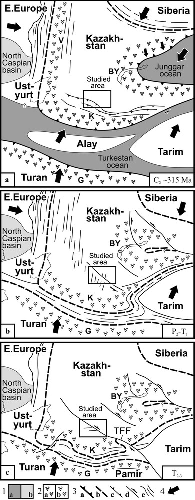
Plate tectonic reconstructions of the Ural and Tian Shan junction for main deformation episodes: a: Late Carboniferous (D1); b: Latest Permian to Triassic (D2); c: Triassic; 1: basins with oceanic crust (a) and thinned subcontinental crust (b); 2: continental margin volcanic arcs: active (a) and extinct (b); 3: active subduction zones (a), collisional sutures (b), major thrusts (c), strike–slip faults (d), trends of folds and reverse faults in collisional belts (e); 4: assumed directions of plate motion with respect to the stable central part of Kazakhstan continent. Abbreviated names of volcanic belts: V: Valerianovskiy; K: Kurama; BY: Balkhash–Yili; G: Gissar; TFF: Talas–Ferghana Fault. Aral sea and Balkhash lake are shown for reference. Masquer
Plate tectonic reconstructions of the Ural and Tian Shan junction for main deformation episodes: a: Late Carboniferous (D1); b: Latest Permian to Triassic (D2); c: Triassic; 1: basins with oceanic crust (a) and thinned subcontinental crust (b); 2: continental margin ... Lire la suite
Fig. 6. Reconstitution de la tectonique des plaques de la jonction Oural–Tian Chan pour les principaux épisodes de déformation : a : Carbonifère tardif (D1) ; b : Permien très tardif à Trias (D2) ; c : Trias ; 1 : bassins à croûte océanique (a) et croûte subcontinentale amincie (b) ; 2 : arcs volcaniques à marge continentale : actifs (a) et éteints (b) ; 3 : zones de subduction active (a), sutures collisionnelles (b), charriages majeurs (c), décrochements (d), orientation des plis et failles inverses dans les ceintures de collision (e) ; 4- directions assumées de mouvements de plaque, en fonction de la partie centrale stable du continent Kazakh. Abréviations des noms de ceintures volcaniques : V : Valerianovskiy ; K : Kurama ; BY : Balkhash–Yili ; G : Gissar ; TFF : faille Talas–Ferghana. La mer d’Aral et le lac Balkhash sont indiqués comme référence. Masquer
Fig. 6. Reconstitution de la tectonique des plaques de la jonction Oural–Tian Chan pour les principaux épisodes de déformation : a : Carbonifère tardif (D1) ; b : Permien très tardif à Trias (D2) ; c : Trias ; 1 : bassins à croûte océanique (a) et croûte ... Lire la suite
Late Carboniferous thrust-and-fold belts in the Karatau and in the Middle Tian Shan [10] trend NW–SE and west–east respectively and demonstrate a common thrust movement towards the continent to the northeast and north. These belts are subparallel to coeval accretionary belts in the South Tian Shan and are discordant with respect to the collisional belt in the Urals. The latter implies Laramide-style deformation in the Karatau and Middle Tian Shan, controlled by subduction processes in the south rather than collision in the west.
East-west-shortening during the D2 event is consistent with compression in the collisional belt of the Urals, and most likely reflects the latest phases of this collision in the Latest Permian and Early Mesozoic (Fig. 6b). Left-lateral movement in a NW–SE direction, which dominated the Karatau area at this time, may have been responsible, at least in part, for the development of the ≈ 150 km wide S-shaped Ferghana sigmoidal fold in the Ferghana ridge of Kyrgyzstan. This giant structure was previously interpreted as a large analogue of numerous S-shaped plunging folds, which formed in the South Tian Shan due to left-lateral motion of the Tarim and Alay blocks to the east and ENE [10,12]. However, bending of the entire South Tian Shan thrust-and-fold belt around the western termination of Tarim, which is observed in the Ferghana ridge [10], could not be explained by the motion of Tarim to the east, and an alternative mechanism is required. We suggest that this deformation may be connected with sinistral motion of the western Tian Shan in a southeast direction and may represent a far-field effect of collision in the Urals. The Latest Permian or Early Mesozoic age of this deformation, based on the age of the D2 event in Karatau, is in agreement with palaeomagnetic data, which indicate counterclockwise rotation in the South Tian Shan during this time [9].
North-south shortening (Fig. 6c), during D3 in the Triassic, apparently occurred due to northward motion of the Turan (Karakum, Afghan–Tadjik) microcontinent, which collided against Kazakhstan and Tarim in the south [10]. This compression continued into the Jurassic, and dextral motion along the Talas–Ferghana fault led to formation of several pull-apart basins which now host industrial oil fields in the South Tourghai and West Tarim [7,12]. Deformation of Jurassic rocks in the entire area from the Tian Shan to northern Kazakhstan is also consistent with north-south shortening.
Our new structural data enable us to characterize the interaction of subductional and collisional systems in the Ural and Tian Shan junction during the Late Palaeozoic and Early Mesozoic. They also provide important clues for the reconstruction of pre-Cretaceous basement structures in the Syrdarya, Aral and Tourghai basins, which represent areas of recent active exploration for oil and gas.
Acknowledgements
We are grateful to Marat Zhaimin and Konstantin Azbel for their help in organizing this study, to Helmut Echtler, Victor Ovchinnikov, Nikolay Sevryugin, Lev Belyakov, Vyacheslav Zhemchuzhnikov and Mark Allen for important comments and discussions. Constructive reviews of the Profs. Alfred Kröner and Wenjiao Xiao are highly appreciated. This study was carried out in the framework of the USGS–Kazakhstan CRADA project. Preparation of the manuscript was supported by program No. 10 of the Earth Science Department of the Russian Academy of Sciences and grant NSh 5508.2008.5.
1 Ages in Ma are given according to Gradstein, et al., 2004 [21].