

1 Geological setting
The Tell domain of Tunisia occupies the eastern part of the “Maghrebides” fold-thrust belt [7–9,12,13,15,16,20,32,34,37,40,41]. It corresponds to a “nappe” domain made by several tectonic units displaced south-eastward.
Rouvier [37], in an extensive previous field and stratigraphic work on the area, had presented convincing data for the allochthony of the area north of the Middle Mejerda valley and the occurrence of displaced Tellian units (Figs. 1 and 2). These units overlie tectonically the Atlas autochthonous substratum. The lower-most unit corresponds chiefly to the Kasseb unit [37] below the Numidian “nappe” which constitutes the uppermost tectonic unit of the Tellian Belt. This thick unit, up to 2500 m [37], extends spatially on the greatest area.
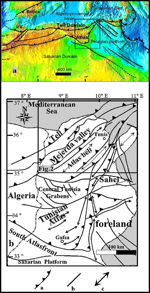
Location of the area studied in the eastern Maghrebian fold thrust belt: a: general context; b: schematic tectonic map of Tunisia compiled from outcrop and subsurface data and situation of the study area around Mejerda Valley (Fig. 2). In 1b: a: major thrust; b: major fault; c: major anticline axis.
Fig. 1. Position de la zone d’étude dans l’édifice des chaînes du Maghreb. a. Schéma structural du Maghreb. b. Schéma structural de la Tunisie compilée à partir des données de surface et de subsurface et situation de la zone étudiée en Tunisie (Fig. 2). Pour la Fig. 1b : a : chevauchement majeur ; b : faille majeure ; c : axe anticlinal majeur.
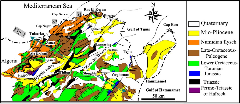
Geologic map of northern Tunisia. S1 and S2: traces of the studied seismic sections.
Fig. 2. Carte géologique de la Tunisie septentrionale. S1 et S2 correspondent à l’emplacement des sections sismiques.
The lithostratigraphic column of northern Tunisia shows the occurrence of a set of detachment levels in the sedimentary pile (Fig. 3). The most important one is represented by the Triassic evaporites. The second major detachment level is represented by the thick Lower Cretaceous shales and marls. The third detachment level occurs in the Late Cretaceous-Paleocene shales. The uppermost one is represented by the Middle-Late Eocene shales. This latter level is important because it allows the decoupling of the Numidian “nappe” over the Paleogene series.
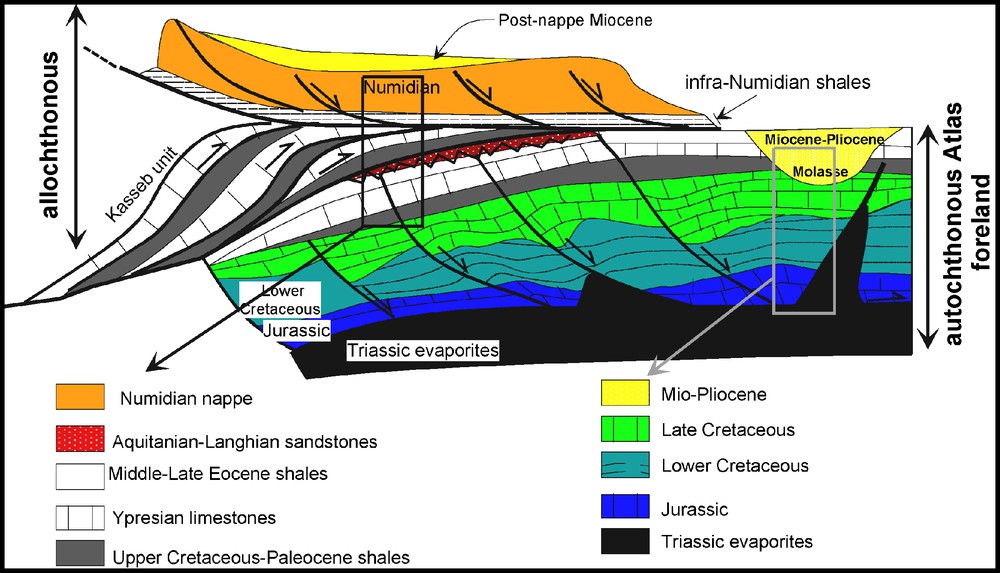
Structural and stratigraphic relationships between the Tell units and its Atlas foreland emphasising the major décollement levels.
Fig. 3. Relations structurales et stratigraphiques entre les unités telliennes allochtones et leur avant-pays atlasique.
These detachment levels played a dominant role in the control of the structural style related to compressional events acting by the Middle Miocene until now with vertical decoupling and detachment of the different structural levels (Fig. 3). Thus, from top to bottom we have: the Numidian “nappe” detached over the Triassic and Middle-Late Eocene shales, the infra-Numidian units detached essentially over Upper Cretaceous-Paleocene shales (as the Kasseb unit), the Late Cretaceous limestones detached over the Lower Cretaceous shales and finally the Jurassic series detached over the Triassic salts.
On the other hand, different studies emphasised the occurrence of Triassic salt movements in northern Tunisia [2,3,11,14,17,26,28,31,32,35–40,41] and beneath the “nappe” [37], especially beneath the Numidian flysch [2,14,38]. Nevertheless, the subsurface structural style remains questionable because of the scarcity of the seismic records, which remains a limiting factor to decipher the structural subsurface style at depth and to have a general overview of the area.
In this paper, we present two recent regional seismic sections as well as our interpretations prior to present and discuss a regional transect through the northern Tunisia belt.
Geographically, the studied area is located on the north-western border of the Middle Mejerda valley between Cap Serrat in the north-west along the coastline and the Ichkeul Lake in the south-east (Fig. 2).
2 Seismic interpretations and discussion
2.1 Seismic section S1
This section cuts the subsurface structures situated between Ras El Koran in the north-west and Ichkeul Lake in the south-east (Fig. 2) and allows us to visualise a complex pattern (Fig. 4). From north-west to south-east it depicts:
- • the Numidian thrust sheet which is pierced in its upper part by a Triassic salt body. At depth, the Triassic salt is presumably incorporated along a basal thrust fault supporting the Numidian which is clearly detached and decoupled from the underlying Atlas type cover (the Sejnane basin);
- • at its southeastern limit, the Numidian flysch unit overlies the autochthonous Oligo-Miocene cover pertaining to the Sejnane autochthonous basin;
- • to the southeast, the seismic section images a diapiric salt body piercing the autochthonous sedimentary cover. This diapir is bounded by two subsident areas with thick Cretaceous to Quaternary sediments: Sejnane basin to northwest and Ichkeul basin to the southeast. These basins seem to be rim synclines controlled by the rising up movements of the growing diapir.
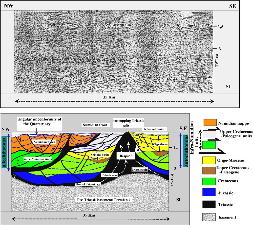
Seismic section S1 deciphering Triassic salt diapirism at the front of the displaced Tellian units. Note the buried Sejnane basin trapped between the Ichkeul diapir and the Numidian unit. Position shown on Fig. 2.
Fig. 4. Section sismique S1 montrant entre autres le diapirisme au front des nappes. Noter le bassin atlasique autochtone de Sejnane, surmonté par le Numidien et limité au sud-est par un diapir important. Pour la position, voir Fig. 2.
Thus, the seismic section outlines the “décollement” of the Numidian flysch on its Atlas substratum and the occurrence of Triassic halokinesis affecting both the autochthonous sedimentary cover and the Numidian “nappe”. On the north-western side of the section and beneath the Numidian unit, a set of faults is observable and may represent imbricated infra-Numidian units (Fig. 4). The loss of the seismic reflection attributes in this part of the section is mainly due to the important thickness of the Numidian and to attenuation of signal by faults and especially by sand-shale alternations in the Numidian flysch section.
2.2 Seismic section S2
This section cuts the area situated between Cap Serrat in the northwest and Ichkeul area in the south-east and images from the north-west to the south-east (Fig. 5):
- • the large extent of the Numidian flysch clearly detached from its substratum by Triassic salt along a basal thrust fault reaching the surface (Fig. 5);
- • a set of tectonic Upper Cretaceous-Paleogene units with a duplex configuration are imaged along the Numidian south-eastern limit. These units are pinched between the Numidian flysch to the north-west and a Diapir to the south-east (Fig. 5). They express an accommodation thrust zone at the eastern edge of the Numidian “nappe”;
- • the Numidian flysch and the Upper Cretaceous-Paleogene units tectonically overlie the autochthonous Atlas series. Pointing up the seismic horizons allows us to identify many angular unconformities within the autochthonous cover (Fig. 5). The upper one is related to the well-known Oligo-Miocene unconformity on top on folded Cretaceous strata.

Seismic section S2 cutting the Numidian front showing the basal thrust of the Numidian and imbrications on its front. Note the buried Atlas type basin beneath the Tellian domain and flowing of Triassic salts that outcrop in the southern edge of the section. Position on Fig. 2. See captions on Fig. 4.
Fig. 5. Section sismique S2 recoupant le Numidien et montrant son décollement généralisé ainsi que le développement, à son front, d’unités imbriquées. Noter sous la nappe du Numidien et les unités paléogènes les structures atlasiques autochtones matérialisées par des blocs basculés et faillées. Pour la position, voir Fig. 2. Même légende que la Fig. 4.
It is worth noting that the Mesozoic autochthonous cover is deformed by a set of subvertical faults that are connected at depth on a general “décollement” level (Fig. 5) lying between Triassic salt and the above lying cover. As for the section S1, there is a loss of seismic signal in the north-western part of the section below 2.5 s two way travel time (TWT).
3 Discussion
The presented seismic sections and their structural interpretation provide new subsurface constraints on the structural style of the Tell domain of northern Tunisia. They show that the Numidian flysch is detached and displaced (Figs. 4 and 5) over the autochthonous foreland on a basal thrust admitting the Triassic salts as “décollement” level. The interpretation depicts also the occurrence of a set of Upper Cretaceous-Paleogene tectonic units at the south-eastern edge of the Numidian nappe. This configuration is in agreement with the structural interpretations presented previously by Rouvier [35] with the Numidian “nappe” overhanging the Kasseb unit below [37]. The structural interpretation allows us to image the subsurface structural style of the autochthonous Atlas structures which are mainly represented by major faults splaying at depth on a basal “décollement” interface situated between the Triassic salt and the Post-Triassic cover (Figs. 4 and 5).
On the other hand, it is worth noting the existence of an angular unconformity separating the autochthonous Oligo-Miocene from the Pre-Oligocene Atlas series (Fig. 6). This configuration outlines a widespread compressional phase during the Middle-Late Eocene [13,16,21,29,30]. This latter can be documented on the field in the autochthonous cover below the Kasseb unit in the Jebel Ben Amara, where Aquitanian-Langhian sandstones lie unconformably on Late Cretaceous-Paleocene folded and faulted strata (Fig. 6). This unconformity which is well imaged by seismic records as well as field outcrop observations confirms the important compression phase dated Middle-Upper Eocene [3,5,21,25,28,29,30,32] and generally called “Atlas event” in the Maghreb [5–7,16,17,21,27–29].
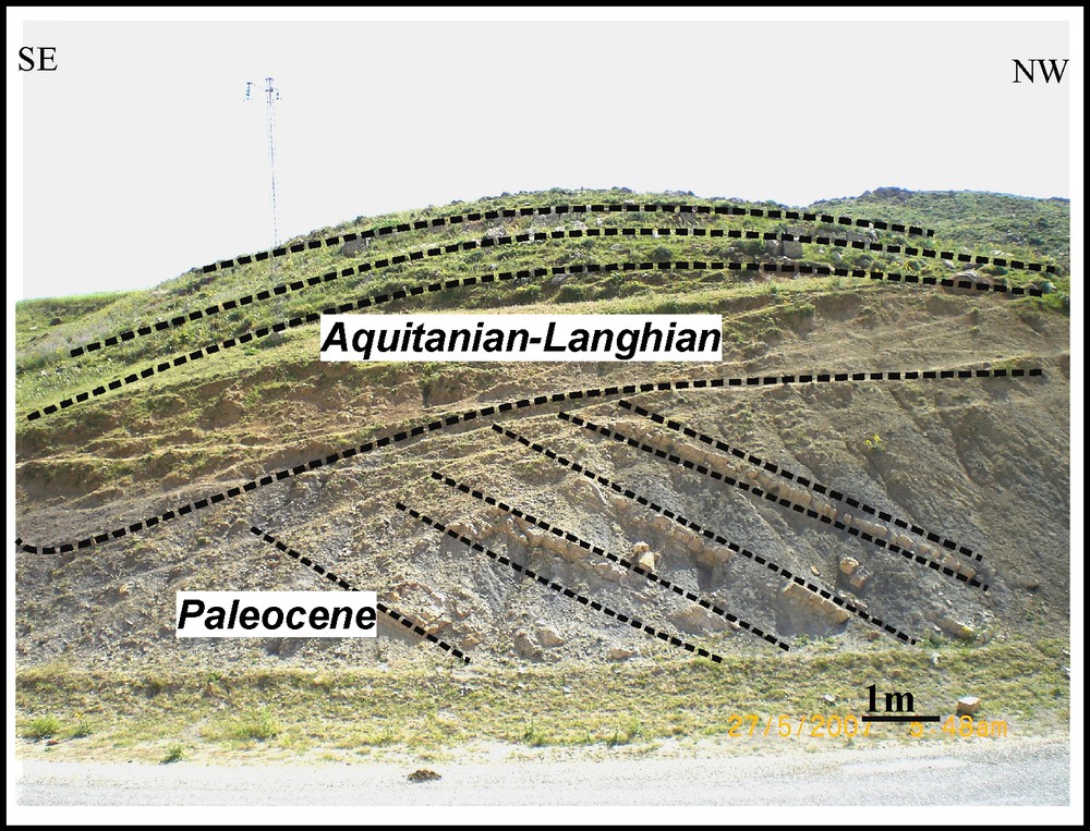
Field photos showing the angular unconformity of the autochthonous Oligo-Miocene on Late Cretaceous and Paleocene shales outlining a pre-Oligocene compression event affecting the autochthonous cover which supports the Kasseb unit in Jebel Ben Amara.
Fig. 6. Photos de terrain montrant la discordance du Langhien sur les marnes paléocènes au niveau du site de Jebel Ben Amara sous l’unité Kasseb, corroborant un évènement compressif anté-Aquitanien et post-Paléocène affectant les séries autochtones.
An important result issued from the structural interpretations of the seismic sections (Figs. 4 and 5) concerns the occurrence of Triassic salts within both the autochthonous and allochthonous covers. As previously outlined by Rouvier [35–37], Perthuisot [38], and Perthuisot et Rouvier [39], it appears that northern Tunisia undergone complex halokinesis during Atlas and Tell orogeny. In fact, the two seismic sections show typical salt diapirs (Figs. 4 and 5) cutting the autochthonous series which are linked to deep seated faults cutting the autochthonous cover. The governing mechanisms of these diapirs are presumably controlled by Jurassic-Lower Cretaceous normal faults inherited from Tethyan rifting [7,22,23,26,27,30,39,41]. In this setting, early extensional movements favoured lateral flow of Triassic salt and uprising of domal structures as it is well documented in other diapir structures as in the Zagros [10,18]. This configuration was discussed by Perthuisot [38], who presented field data in agreement with earlier vertical movements and vertical growth of diapirs that started during Lower Cretaceous. Such faults may represent major paleogeographic trends controlling sedimentary infill and thickness variations. So, one can consider that the south-eastern limits of the “nappes” coincided at a time with a weak zone pierced by important diapirs especially during Paleogene times. This is supported by Paleogene paleogeographic synthesis [3,4,13,14,43]. Actually, Yaich et al., [43] locate a high zone around the “Zone des Dômes” where Oligo-Miocene series locally pinch out. In addition, many works emphasize the occurrence of reworked Triassic material in the Paleogene series around the diapirs [11,13,17,38,41] in agreement consistently with earlier piercement of the Triassic salt.
Taking into account that the Triassic evaporites also cut the Miocene-Quaternary cover along the present day Numidian front (Figs. 4 and 5), it appears that important vertical halokinesis movements also occurred during this time period. The observed halokinesis activities can be partly explained by tectonic loading at the northern edge of the overthrust due to advancing units.
Concerning the Numidian “nappe”, the seismic sections (Figs. 4 and 5) outline the occurrence of thrust faults at its south-eastern limit and south-facing normal faults at its rear. This configuration is related to the gravity driven mechanisms with an accommodation thrust zone at the southeastern limit of the upper-most displaced unit (Numidian) concomitant to normal faults. This configuration reminds the structural style of an accretionary prism [40].
To summarise the overall structures of northern Tunisia we propose a regional transect cutting the whole northern Tunisia fold thrust belt (Fig. 7). This section striking NW-SE stretches from the Mediterranean coast in Tabarka in the northwest, to the Zaghouan thrust-fault in the eastern Atlas. It is obtained by a compilation of seismic sections [13,24,26–28,30,31] petroleum wells, field investigations of our predecessors [1,2,9,11,13,14,17,21,22,31,32,36–41] and geological mapping [11,14,22,36–40,41].

Regional structural transect in northern Tunisia from the Tell domain in the northwest to the eastern Atlas foreland onshore (the gulf of Hammamet). Note the duplex configuration beneath the Numidian upper unit (see text for discussion).
Fig. 7. Transect structural régional à travers la Tunisie septentrionale traversant le Tell, le chevauchement de Zaghouan et l’avant-pays de l’Atlas (voir la discussion dans le texte).
The section shows that the Tell thrust belt is made by a set of tectonic displaced units with the Numidian unit occupying the upper-most structural level of the belt. The transect (Fig. 7) as well as the seismic lines (Figs. 4 and 5) are in agreement with the fact that the Numidian flysch is detached on Paleocene-Eocene shales. The geometrical position of the Numidian is in accordance with a gravity driven “nappe” issued from the unroofing of the underlying duplexes. The seismic sections indicate that the Numidian thickness could in place be due to tectonic duplication. Such is the case at its south-eastern limit [33,42]. Concerning the Triassic salts of the Numidian sole, they appear to have been incorporated at the footwall of the unit from the underlying para-autochtonous series during the southwards gliding of the nappe on top of the duplexed structures. So, structures all support a thin skin tectonic style.
To the south-east, the Mejerda trough corresponds to a Miocene-Quaternary depocenter at the front of the Tell (Fig. 7). This depocenter is located over a crustal anomaly outlined by enhanced gravimetric anomalies [19] which corresponds at depth to a major north-dipping detachment fault decoupling the autochthonous cover from its Paleozoic substratum [6,7,15,20,32,34]. In fact and on the northern side of the Mejerda valley in Hairech (Fig. 2), the Permo-Triassic substratum locally crops-out at the front of the Tell. This thrust fault represents a major structural feature separating the Tell domain from its foreland. It can be considered as the southern limit of the Tell corresponding regionally to the southern Tell front. Comparison of the presented structural section with those of our predecessors in Algeria [5–7,20,32,34] are in agreement with thrusting of the Tell units over Miocene series. As in the Algerian Tell domain, the most recent strata thrusted by the Tellian units are Langhian-Serravallian. Otherwise our transect is in agreement with those presented in Algeria domain with duplex configuration below the uppermost elevated detached units [5–7]. In this setting, it is likely that the Numidian corresponds to a gravity driven “nappe” detached by unroofing of the underlying duplexes.
After the emplacement of the Numidian “nappe” over an already structured cover, important compressional events occurred during the Serravallian-Tortonian. They correspond to the so-called Alpine phase [7–9,12,16,37–39,41], which is responsible for the folding of the nappes [7]. These compressional events were recorded by an important erosion phase sourcing the Miocene continental molasses trough of the Mejerda valley with an overall thickness of 1000 m of Miocene-Pliocene series (Fig. 7).
Following these events, an important extensional phase occurred during the Messinian-Pliocene expressed by normal faulting affecting the Tell domain. This event well recorded offshore as well as in the frontal part of the Tell is interpreted to be due to back extension and fore extension of the accretional prism of the Tell domain of northern Africa [40] originated by isostatic collapsing of the thrust belt.
4 Conclusion
The presented seismic data provide new constraints on the subsurface structures of the Alpine chain of Tunisia. Our results fully support our predecessors’ interpretations of the area thus especially those of Rouvier [36,37] and Perthuisot [38,39].
The seismic sections in accordance with field studies outline that the Numidian flysch is completely detached from the autochthonous Atlas substratum. Along its south-eastern limit Upper Cretaceous-Paleogene imbricated units can be considered as equivalents of the Kasseb nappe [37]. Moreover, the seismic interpretations allow us to recognise diapiric structures related to halokinesis of the Triassic salts. Two types of halokinetic salt bodies can be seen depending on the involved series: diapirs cutting the autochthonous Atlas substratum and diapirs cutting the thrust sheets, in particular the Numidian unit. Thus our structural interpretations show that salt tectonics played a dominant role during basin developments as well as during the building of the Tell.
The proposed structural transect cutting the whole Tunisia thrust belt (Fig. 7) also outlines the “décollement” of the Numidian over the Eocene shales and locally on Upper Cretaceous shales. Triassic salts are also incorporated mechanically at the sole thrust of the Numidian nappe. This salt is originated from the underlying duplexes where they represent the major “décollement” level. So, as emphasised by Perthuisot [38], Jauzein and Perthuisot [22], Perthuisot and Rouvier [39] and Turki [41], during basin inversions, pre-existing salt structures were significantly reactivated in response to build up of compressional stresses and emplacement of the thrust-sheets.
Acknowledgements
The authors wish to acknowledge the reviewers of the work: Dominique Frizon de Lamotte and an anonymous reviewer. Their comments and suggestions improved the first draft of the paper.