

1 Introduction
The Arabian Peninsula is of special interest in the context of two related issues in Quaternary research. The first topic is investigating the evolution and impact of past climate change on arid zone environments. The remains of ancient lake deposits found in the Arabian deserts document that in the past the region experienced much more humid conditions than present [29]. Speleothem records from caves in Oman indicate that such humid phases did not only occur during the Holocene climate optimum but also during times of previous interglacials at mid to high latitudes [5,9]. The increased availability of moisture over Arabia was apparently caused by a shift of the InterTropical Convection Zone (ITCZ), and hence the Monsoon Belt, to the north. On the other hand, extensive dune fields and sand seas were presumably deposited during times of hyperarid to arid conditions that prevail today. However, it has to be kept in mind that aeolian deposition is not a straightforward proxy for aridity since sediment availability, as well as transport and preservation potential, are the underlying and controlling processes.
The shifting between more arid and more humid conditions is of prominent interest when reconstructing the migration of early humans and especially Homo sapiens out-of-Africa, the second major topic of Quaternary research in Arabia. Today, most parts of the southern Arabian Peninsula would be inaccessible for Palaeolithic hunter-gatherer communities due to limited availability of food and, in particular, water. Hence, it appears that the only possible migration route from Africa into the Eurasian continent would have been along the River Nile, through the Sinai and into the Levant (Fig. 1). However, during times when Arabia was under monsoon influence, increased humidity and the resulting improvement in life-supporting environmental conditions would have probably allowed migration through the interior of the peninsula. As a consequence, another potential migration route would be the narrow Bab al Mandab Strait and continuing migration into the southwestern corner of Arabia and beyond [35] (Fig. 1).
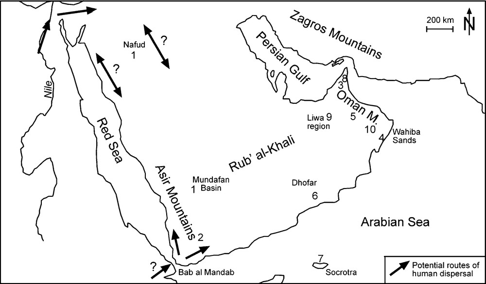
Map of the Arabian Peninsula with location of relevant sites mentioned in the text and potential routes for human dispersal [35]. Lake sites: 1. Mundafan and Nafud [29,45,54,55]. 2. SW Yemen [7,26,27]. 3. United Arab Emirates [31,32]. 4. Wahiba Sands [44]. Speleothems: 5. Hoti Cave, Oman Mountains [5]. 6. Qunf and Defore Caves, Dhofar [9]. 7. Dimashim Cave, Sokrota Island [10]. Aeoilan sediments: 8. NE Rub’ al-Khali [19]. 9. Liwa region [50]. 10. Wahiba Sands [38,40,43].
Fig. 1. Carte de la Péninsule arabique montrant les sites mentionnés dans le texte ainsi que les routes de migrations potentielles des hommes [35]. Sites lacustres : 1. Mundafan et Nafud [29,45,54,55]. 2. Sud-Ouest du Yemen [7,26,27]. 3. Émirats Arabes Unis [31,32]. 4. Massif dunaire des Wahibas [44]. Spéléothèmes : 5. Grotte d’Hoti, Montagne d’Oman [5]. 6. Grottes de Qunf et de Defore, Dhofar [9]. 7. grotte de Dimashim, Sokrota [10]. Sédiments éoliens : 8. NE Rub’ al-Khali [19]. 9. Liwa [50]. 10. Massif dunaire des Wahibas [38,40,43].
The present contribution will give a general overview on the Quaternary environmental conditions in the Arabian Peninsula for the time since the latest Middle Pleistocene, based on evidence from former lake deposits and aeolian sediments. This article will concentrate on the eastern part of the Arabian Peninsula (i.e. the territories of the United Arab Emirates and the Sultanate of Oman) as the number of palaeoclimate studies from other areas (i.e. Saudi Arabia and Yemen) is presently too limited to allow the reconstruction of a comprehensive picture of the Quaternary environmental history. The speleothem record of Arabia, reflecting periods of increased humidity, has recently been reviewed [10] and two recent publications have given some initial insight into the age and origin of alluvial fan formation in the interior of Oman [2], as well as in central Saudi Arabia [30].
The present study will focus on palaeo-environmental implications as well as the age and, specifically, discuss controversies in the chronology of both ancient lake as well as aeolian sediments. Since the backbone of the chronology in Arabia, especially for pre-Holocene times, is based on luminescence dating, the following will refer to (“absolute”) years before today. It will be stated explicitly when referring to uncalibrated radiocarbon ages before presence. All ages are reported using the SI unit anni (years; 1 ka = 1000 a).
2 Lake deposits
The first dated evidence for a past humid phase in the Arabian Peninsula was a set of radiocarbon ages for ancient lake deposits from the Saudi Arabian deserts [29]. Together with further radiocarbon ages that were provided later [54,55], two periods of lake development between ca. 35–20 ka and ca. 9–6 ka ago (uncalibrated 14C ages) have been suggested. The later phase, usually referred to as the Holocene humid period, has been recognised in a variety of records from across the northern subtropics [14,49]. Beside the early work in Saudi Arabia, more recent and more detailed studies on such lake deposits are available from Yemen [7,26,27] and the Emirates [31,32], as well as Oman [44]. The Holocene humid period is also prominent in the speleothem record [9,10]. About 4.4% of the total area of Arabia was covered by lakes during the peak of the wet phase [21]. The overall picture from the above mentioned studies is a savannah-like environment with the presence of herbivores and human occupation in the Arabian Peninsula during the Early to Mid Holocene, dated to about 10–5.5 ka ago [32,44].
More controversial is the humid period inferred from radiocarbon dating with ages between ca. 35–20 ka (uncalibrated). This period does not, in contrast to the Holocene humid period, coincide with a pronounced peak in Monsoon Index but rather with a low during the time just before the Last Glaciation Maximum (LGM, Fig. 2). In this context, it has to be considered that evidence for this earlier humid period is mainly based on the dating of bulk carbonate materials. Radiocarbon dating of such materials can, however, be affected by postdepositional uptake of younger carbon, which may lead to incorrect (underestimated) ages [11]. Improved sample preparation procedures now help to avoid contamination problems [20], but these techniques were not available for older studies, on which the present chronology still relies. In this context, it has been demonstrated that uplifted coral reefs from the Persian Gulf dated by radiocarbon to some 30–20 ka, actually represent a Last Interglacial depositional age [36,39]. Radiocarbon ages based on bulk carbonate samples of ancient lake deposits from the Arabian deserts may also have been affected by contamination with younger carbon, especially considering that these samples most likely interacted with water-dissolved CO2 during the Holocene humid period. The assumption that a humid period occurred between ca. 35–20 ka ago (uncalibrated) may therefore be based on inappropriate dating procedures. This issue needs to be readdressed by carefully evaluating the existing radiocarbon data set and by using modern radiocarbon preparation, as well as alternative dating approaches such as luminescence, for establishing a more reliable chronological framework for these deposits.
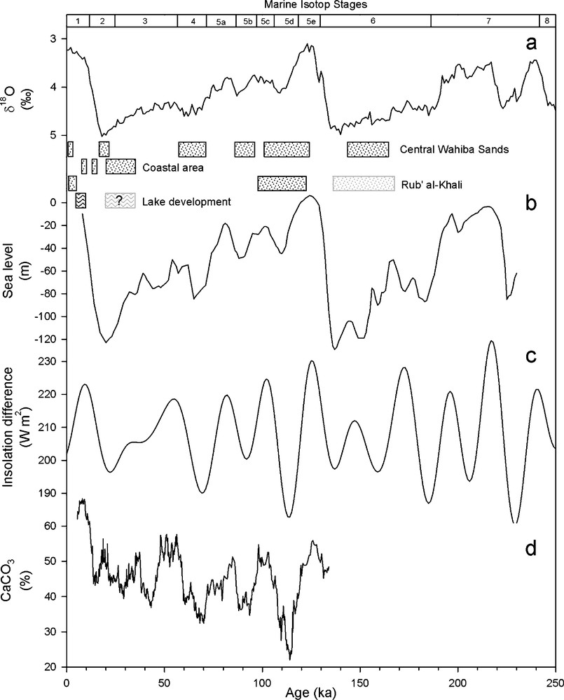
Aeolian deposition (dotted areas) and phases of lake development in the context of global and regional environmental conditions. a: benthic δ18O stack as a measure of global ice volume and (inversely) of global sea level [28]; b: reconstruction of the position of global sea level compared to the present situation [52]; c: Monsoon Index calculated from the insolation difference between the northern and southern hemisphere as an indicator for theoretical monsoon strength [25]; d: CaCO3 content in core 70KL as an inverse measure of dust input into the Arabian Sea [24,25].
Fig. 2. Dépôts éoliens (zones en pointillés) et phases d’extension lacustre dans leur contexte environnemental global. a : mesures du volume de glace global et du niveau moyen des mers à partir des données isotopiques (δ18O) des foraminifères benthiques [28] ; b : reconstitution de la position du niveau marin global comparée à la situation actuelle [52] ; c : index de mousson calculé par différence d’insolation entre l’hémisphère nord et sud, utilisée comme indicateur de l’intensité théorique de la mousson [25] ; d : teneur en CaCO3 dans la carotte 70KL en tant que mesure inverse des apports de poussières dans la Mer arabique [24,25].
3 Aeolian deposition
Although large parts of the Arabian Peninsula are covered by widespread and thick aeolian deposits, the present knowledge of their age and origin is limited to two areas, the Wahiba Sands (Sultanate of Oman) and the eastern Rub’ al-Khali (United Arab Emirates [UAE]). This is due to the fact that access to most of the region has been difficult for both natural as well as political reasons in the past. Furthermore, direct determination of the age of aeolian deposits only recently became available through luminescence methods [41]. Earlier studies [1,8,16] remained mainly descriptive and could only tentatively ascribe aeolian deposition to absolute timeframes. A first set of published luminescence ages [22] together with some unpublished data [18,42] forms the chronological basis for a previous review on the chronology of palaeo-environmental change in SE Arabia [17]. However, a substantial number (> 200) of luminescence ages has recently been provided and the following aims at providing a synthesis of the data now being available for SE Arabia.
3.1 Wahiba Sands
The Wahiba Sands are located in the easternmost corner of the Arabian Peninsula, on the territory of the Sultanate of Oman, and cover an area of about 10,000 km2. The area is characterised by up to 60 m high megadunes, oriented longitudinally from south to north. The dune ridges follow the present dominant wind pattern, i.e. the south-west monsoon that is active during summer, when the ITCZ establishes over southern Arabia. Slightly to intermediately cemented aeolian sandstones (aeolianites) are found in outcrops along the western (Wadi Andam) and southern margin (Arabian Sea coast) of the Wahiba Sands. These sediments have recorded the former transport, and hence wind direction, in the form of foresets, indicating northbound transport.
A first systematic and multidisciplinary research project in this region was carried out in the 1980s resulting in benchmark publications on the geomorphology of the dunes [53], and on sedimentological and lithological features of the aeolian sediments [12]. Three units of aeolian deposits have been distinguished, the so-called older and younger aeolianite, as well as modern, unconsolidated dunes. A marine origin for the sediment was identified by the high amount of shell debris and it has been concluded that the formation of the aeolian deposits was related to periods of low global sea level [12,51]. At that time, however, it was not possible to confirm these assumptions with independent age control.
A suite of nine luminescence ages was later published [22], but very little information has been provided about the geological context of the samples and the number of dates is rather limited considering the size of the area. According to this publication, aeolian deposition occurred during the Early Holocene (10 ± 4 ka, 10 ± 1 ka), the LGM (18 ± 3 ka, 23 ± 3 ka), early Marine Isotope Stage (MIS) 5 (110 ± 11 ka, 117 ± 12 ka, 112 ± 12 ka) and MIS 7 (229 ± 19 ka).
The lithology [13,33,34], sedimentology [43] and in particular the age of the aeolian deposits of the Wahiba Sands [38,40] were later investigated in more detail. The results of these studies generally confirmed previous conclusions on the marine origin and the age of the Wahiba Sands, but also revealed a more complex origin and history of aeolian deposition. Luminescence dating of sediments outcropping in the western Wahiba Sands demonstrates that the Al Jabin unit (older aeolianite) was deposited during the glacial period preceding the Last Interglacial (MIS 6, 186–130 ka). The next prominent period of aeolian deposition (Al Hibal unit) occurred during MIS 5d (120–106 ka), followed by minor deposition (Hawiyah unit) during MIS 5b (97–86 ka) and MIS 4 (71–57 ka) [38,43] (Figs. 2 and 3), which was identified by dating samples from two drill cores recovered from the central Wahiba Sands.

Schematic sketch of the Quaternary sedimentary record from different areas of the Wahiba Sands, Oman, with luminescence ages in ka [38,40,43]. Please note different scale for sections from the coastal area.
Fig. 3. Présentation schématique des enregistrements sédimentaires quaternaires pour différents secteurs des Wahiba Sands, Oman, avec indication des âges par luminescence [38,40,43]. Noter la différence d’échelle pour les sections du littoral.
Luminescence dating also revealed aeolian deposition during MIS 3-1 (Qahid unit). Six ages, representing a mean of 20 ± 2 ka, indicate considerable deposition of sand in the northern Wahiba Sands during the peak of global glacial conditions (LGM) at ca. 20 ka ago (Figs. 3 and 4) [38,43]. In the coastal area, three different aeolian units can be distinguished based on sediment logging: a basal dune, a sand sheet and an upper dune deposit. It has been shown that the tripartition inferred from field observations is confirmed by luminescence dating [40] but the chronological data is reinvestigated here using a strict statistical approach [15]. From the statistical point of view, averaging an entire suite of individual ages from one stratigraphical unit is allowed when the χ2 test results in values less than n–1, indicating that all samples belong to one particular frequency distribution. In geological terms this means that ages can, in this case, be interpreted as one depositional event, with the likely maximum duration given by the standard variation. For the samples from the coastal area of the Wahiba Sands, mean ages of 14 ± 1 ka for the sand sheet (n = 7, χ2 = 2.6) and of 9.0 ± 0.9 ka for the upper dune unit (n = 9, χ2 = 7.0) are calculated. For the lower dune unit, χ2 = 62.8 indicates that no averaging of the ages is allowed and that this unit comprises a considerable amount of time. According to the available data, this phase of aeolian deposition occurred between ca. 35–20 ka ago (Fig. 4). It is interesting to note that in the available data set from the coastal area only few ages fall into the LGM, and that most ages significantly pre- or postdates this period (Fig. 4). This is in contrast to the central Wahiba Sands, where important sedimentation has been observed exclusively during the LGM with no deposition just before and just after this period (Figs. 2–4). This spatial difference in deposition times was possibly caused by reduced preservation potential in the coastal area due to a low position of the groundwater table during the LGM. Sand was transported further to the north, where wind strength declined when approaching the ITCZ and deposition was triggered by means of limited transport capacity [40]. Before and after the LGM, the preservation potential was apparently high enough to prevent substantial sand transport to the north (Table 1).
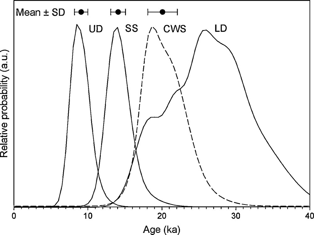
Probability density function of luminescence ages determined for different stratigraphical units of the coastal area (“younger aeolianite”), compared to ages from the central Wahiba Sands (dashed line), falling in the range of the Last Glaciation Maximum [38,40]. The plot reveals three distinct peaks (means of clusters) of aeolian deposition at 9.0 ± 0.9 ka, 14 ± 1 ka and 20 ± 2 ka, as well as a period between 20–35 ka. UD: upper dune unit; SS: sand sheet unit; LD: lower dune unit; CWS: central Wahiba Sands.
Fig. 4. Fonctions de densité de probabilité des âges obtenus par luminescence pour différentes unités stratigraphiques du secteur côtier (« éolianite récente »), et du secteur central des Wahiba Sands (ligne tiretée), correspondant au dernier maximum glaciaire [38,40]. Trois pics distincts (moyennes de clusters) de sédimentation éolienne sont identifiés à 9,0 ± 0,9 ka, 14 ± 1 ka et 20 ± 2 ka, de même qu’au cours de la période 20–35 ka. UD : unité dunaire supérieure ; SS : couverture sableuse ; LD : unité dunaire inférieure ; CWS : zone centrale du massif dunaire des Wahiba Sands.
Periods of aeolian accumulation recognised in the eastern Arabian Peninsula.
Tableau 1 Périodes d’accumulation éolienne, reconnues dans la partie orientale de la Péninsule arabique.
| Time period | Type of sediment | Area | Reference |
| Modern (< 2 ka) | Uncemented dune | Central Wahiba Sands (Oman), Idhn (UAE) | [19,38,43] |
| Late Holocene (5.5–2.5 ka) | Uncemented dune | Liwa region (UAE) | [50] |
| Early Holocene (11.5–9.0 ka) | Cemented dune (Oman), uncemented dune (UAE) | Costal area (Oman), Awafi (UAE) | [19,22,40] |
| Late Glacial (∼ 14 ka) | Cemented sand sheet | Costal area (Oman) | [40] |
| Last Glacial Maximum (∼ 20 ka) | Uncemented dune | Central Wahiba Sands (Oman) | [22,38,43] |
| MIS3-2 (35–20 ka) | Cemented dune | Costal area (Oman) | [40] |
| MIS 4 (∼ 68 ka) | Cemented dune | Central Wahiba Sands (Oman) | [38,43] |
| Early MIS 5 (∼ 112 ka) | Cemented dune | Central Wahiba Sands, Al Jabin (Oman), Liwa region (UAE) | [22,38,43,50] |
| MIS 6 (∼ 150 ka) | Cemented dune | Al Jabin (Oman), Liwa region (UAE) | [38,43,50] |
Three distinct phases of submodern dune accumulation have been observed in the central Wahiba Sand [38], dated to about 1.8 ka, 0.7 ka and the present (0.04 ± 0.01 ka), and huge dunes are still actively migrating parallel to the coast. It has therefore to be considered that aeolian transport and temporal deposition prevail in the Wahiba Sands under the present arid climatic conditions.
3.2 Eastern Rub’ al-Khali
The complex pattern of dunes in the eastern Rub’ al-Khali is oriented in the direction of the Shamal, a persistent north-westerly wind over northern Arabia during summer. Six phases of dune formation can be distinguished on satellite images and are generally oriented according to the present wind regime. In some areas, cemented aeolian sediments are found below the dunes and have been attributed to two individual periods of deposition [16,50]. As a consequence, modern aeolian morphology reflects a combination of active dunes and partly cemented palaeo-dune bedforms.
First results on the chronology of aeolian deposition in this region [18,22,42] were later discussed in a palaeo-environmental context [17] and phases of dune building activity around 160–130 ka, 110 ka, 60–50 ka and 15–12 ka were identified. These authors concluded that aeolian accumulation coincides with globally glacial periods and low sea level in the Persian Gulf, providing the necessary sediment supply. Fourteen luminescence ages were later published for two dune profiles from the Ras Al Khaimah area (NE UAE) [19] (Fig. 5). At the Awafi site, ages for the lower 14 m of the dune indicate deposition as one event somewhere between 11–9 ka ago and a submodern age (0.19 ± 0.04 ka) was determined for a sample from 0.5 m below the dune crest. At the Idhn site, luminescence ages range between modern (0.08 ± 0.02 ka) and ca. 1 ka. Twelve luminescence ages for one core from the Liwa Oasis, originally ranging from 6.8 ± 0.9 ka to 2.6 ± 0.3 ka [3,4], were later recalculated and age estimates between 5.4 ± 0.6 ka and 2.7 ± 0.2 ka have been reported [50].

Schematic sketch of the Quaternary sedimentary record of the eastern Rub’ al-Khali with luminescence ages in ka (data from [19,50]). Please note different scale for the Awafi and Idhn sites.
Fig. 5. Présentation schématique des enregistrements sédimentaires quaternaires de l’Est du Rub’ al-Khali avec les âges fournis par luminescence en ka (données extraites de [19,50]). Noter la différence d’échelle pour les sites d’Awafi et de Idhn.
A suite of 56 luminescence ages, 44 for samples from five individual cores (Fig. 5), penetrating down to a maximum of 100 m depth, and twelve samples taken from an outcrop, has been produced for sediments from the Al Qâfa/Liwa region [50]. This paper provides a comprehensive description of both the geological context (i.e. logs of the cores and outcrop descriptions) as well as detailed information on the dating procedures.
A summary of the original data for the UAE is shown in Fig. 5 [19,50]. Nearly half of the ages represent dune deposition after ca. 5.5 ka, hence postdating the Holocene humid period. From this data, it was concluded that aeolian deposition occurred during MIS 5 (130–75 ka) and parts of MIS 1 (6–2 ka), and that the preserved record of aeolian deposition in the southern Arabian Peninsula occurred within relatively humid interglacial phases, rather than arid intervals during mid-latitude glacial periods [50]. It was inferred that the aeolian system was neither sediment-supply nor transport limited, but that deposition was limited by preservation potential. For the latter, it has been assumed that the position of the groundwater level played an important role for aeolian preservation, which is high only during relatively humid phases and periods of high global sea level.
4 Discussion
The conclusions that most sand deposition in SE Arabia occurred during relatively humid interglacial periods [50] is in contrast to earlier assumptions about the timing and forcing of aeolian sedimentation in the region. Previously, it was assumed that aeolian deposition occurred during times of global sea level lows and was forced by sediment-supply [12,16,17,38].
The alternative interpretation [50] is based mainly on using probability density functions to discriminate between individual periods of aeolian deposition, but this approach does not consider stratigraphical evidence for either the Liwa region or the sediment record from the Wahiba Sands, where detailed logging of outcrops is available [43]. Mixing dating results from different stratigraphical unit can, however, mask individual peaks of ages. The previously published dating results are here statistically re-investigated by considering the stratigraphical context. In the Wahiba Sands, the Al Jabin and Al Hibal units are separated by a period of fluvial activity and calcrete formation, the Al Batha unit that is tentatively correlated to MIS 5e [43]. The mean luminescence age for aeolian deposits of the Al Jabin unit is 153 ± 10 ka (n = 13, χ2 = 3.0) and hence implies a correlation with MIS 6, i.e. a period representing pronounced glacial conditions at mid-latitudes and low global sea level (Figs. 2 and 6). For the Al Hibal unit, mean luminescence ages of 113 ± 11 ka (n = 11, χ2 = 6.7) for samples from outcrops and of 111 ± 10 ka (n = 27, χ2 = 23.4) for samples from core WDR 1 are calculated [38,43]. These ages are statistically significantly younger than for the Al Jabin unit but are identical with a mean of 109 ± 13 ka (n = 12, χ2 = 21.0) for samples from an outcrop in the Liwa region [50] (Figs. 4 and 6). The rather large χ2 value for the latter suite of ages is expected to result from either unidentified outliers or from a too optimistic calculation of errors of individual samples. Furthermore, aeolian deposition in the lower part of Liwa core 47 gives a mean age of 147 ± 30 ka (n = 10, χ2 = 57.3), but a rather high standard deviation and χ2 value. However, as has already been indicated, these samples are rather problematic [50]. This is due to the fact that these sediments have apparently been partly altered by interaction with groundwater that can cause problems in dose rate determination [41]. Removing three obvious outliers from the data set results in a mean age of 147 ± 19 ka (n = 7, χ2 = 11.0), implying a correlation of this phase with MIS 6.
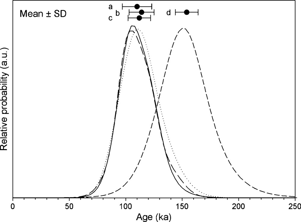
. Probability density function of luminescence ages determined for different aeolian units in Oman and UAE (data from [38,40,43,50]). a: Al Hibal unit situated on top of fluvial sediments (Al Batha unit) in core WDR1 (solid line); b: aeolian sand found stratigraphically above the prominent calcrete in outcrops of the Al Jabin Plateau (dashed line); c: dune sands in outcrops in the Liwa region (dotted line); d: aeolian sand found stratigraphically below the prominent calcrete at Al Jabin (Al Jabin unit) (short dashed line). Mean ages for a–d are 110 ± 10 ka, 113 ± 11 ka, 109 ± 13 ka and 153 ± 10 ka.
Fig. 6 Fonctions de densité de probabilité des âges obtenus par luminescence pour différentes unités éoliennes d’Oman et des Émirats (données extraites de [38,40,43,50]). a : unité Al Hibal située au sommet de sédiments fluviatiles (Al Batha) dans la carotte WDR1 (trait continu) ; b : sables éoliens trouvés stratigraphiquement au-dessus d’un affleurement de calcrète sur le plateau d’Al Jabin (trait discontinu) ; c : sables dunaires en affleurement dans la région de Liwa (trait pointillé) ; d : sable éolien trouvé stratigraphiquement au-dessous d’un niveau de calcrète à Al Jabin (unité Al Jabin) (trait discontinu court). Les âges moyens pour a et d sont 110 ± 10 ka, 113 ± 11 ka, 109 ± 13 ka et 153 ± 10 ka.
In the alternative interpretation, it has also been assumed that both the Holocene, as well as the entire MIS 5, represent interglacial periods with relatively humid conditions [50]. However, for the Holocene, it is known from a variety of records from all over the present African/Arabian desert belt that the pronounced phase of increased humidity ended somewhere between 6–5 ka ago [10,14,23]. Only the first half of the present interglacial represents pronounced wet conditions and luminescence ages for dune stabilisation less than 6 ka do not actually fall into a relatively humid period but rather into an arid period. The same applies to the underlying assumption in the alternative interpretation [50] that MIS 5 (130–75 ka), as a whole, represents humid interglacial conditions. However, actually only MIS 5e represents the Last Interglacial (ca. 130–120 ka ago) [47]. The rest of MIS 5 reflects a rather dynamic period with prominent changes in environmental conditions, as, for example, demonstrated by mid-latitude vegetation records [6,37]. Although the continental palaeo-environmental record of Arabia is at present still fragmentary, the speleothem record [5] and in particular marine records from the Arabian Sea [24,48], support pronounced shifts between more arid and humid conditions for MIS 5 (Fig. 2). These geological observations are in phase with the theoretical Summer Monsoon Index that has been calculated from astronomical forcing parameters [25]. Furthermore, the assumption of the alternative interpretation [50] that MIS 5 represents relatively high sea level is incorrect as it has been shown that global sea level dropped by at least 40 m just after the Last Interglacial [52] (Fig. 2), and the Persian Gulf, of between 20–40 m depth, was a dry basin during most of the Late Pleistocene [36,51].
In summary, the statistical analyses used here show that the most prominent phases of aeolian deposition in the eastern Rub’ al-Khal and the Wahiba Sands have apparently been synchronous. Significant deposition of aeolian sand occurred during MIS 6 (186–130 ka) and MIS 5d (115–106 ka). The first period represents full glacial conditions on a global scale and a low global sea level (Fig. 2). The second represents a period of a rapid drop of sea level and, according to theoretically calculated Monsoon Index, possibly one of the driest periods of the last 200 ka (Fig. 2). In contrast to the alternative interpretation [50], but in agreement with many earlier publications [16,17,51], it is concluded here that aeolian deposition has mainly been controlled by sediment supply. This mechanism can also explain the lack of MIS4-2 deposits in the eastern Rub’ al-Khali, and their presence in the Wahiba Sands. The ongoing lowering of sea level during that time exposed more and more parts of the continental shelf of the Arabian Sea south of the Wahiba Sands, providing additional sources for sediment supply. The Persian Gulf had most likely completely dried out already during MIS 5d due to its general shallowness. Ongoing stabilisation of the surface in the basin hampered blow-out of aeolian material [51], hence cutting of further sediment supply. Thus, while the Wahiba Sands gained further sediment supply during later parts of the Late Pleistocene, aeolian deposition in the eastern Rub’ al-Khali stopped as sediment supply was cut-off.
This interpretation is supported by the input of aeolian dust from the Persian Gulf into the Arabian Sea [24] (Fig. 2). The peak in dust flux during MIS 5d is related to the drying out of the Persian Gulf and resultant sediment availability in both sand (UAE dunes) as well as silt (Arabian Sea dust flux). Nevertheless, the general circulation pattern over Arabia, i.e. the position of the ITCZ during summer, did apparently not significantly change during times of low monsoon circulation. The geological evidence discussed from the Wahiba Sands [37] is in contrast to interpretations of other authors [17,48] but supported by the specific metrological situation. It has to be kept in mind that the major driving factor behind the formation of the ITCZ is establishing a system of low pressure cells due to more elevated heating over land compared to the ocean. This temperature difference is very pronounced in southern Arabia due to up-welling of cold waters in the Arabian Sea [46]. Hence, while the ITCZ may establish a more southerly position during glacial times in other areas such as Africa or South America, the specific boundary conditions in southern Arabia apparently fixed the ITCZ at more or less its present position even during times of low monsoon circulation.
5 Conclusions
The most prominent and direct effect of Middle to Late Quaternary climate on environments in the Arabian Peninsula is the change in moisture supply caused by the strengthening and weakening of monsoon circulation. It has been shown that the first half of the Holocene was characterised by much more humid conditions than today, which certainly favoured human occupation of the region. Further wet phases occurred earlier during the Quaternary, but it is likely that many such periods have not been securely identified yet, especially in the lake record that has been subject to later erosion. In this context, there is an urgent need for further geochronological and palaeo-environmental data in the context of deciphering potential migration routes of early humans out-of-Africa.
This publication has demonstrated that the major phases of aeolian deposition in both the Wahiba Sands and the eastern Rub’ al-Khali have been synchronous and were controlled by sediment supply related to the lowering of global sea level. The lack of dune accumulation in the eastern Rub’ al-Khali during many parts of the last glacial cycle (MIS 4–2) is explained by limited sediment-supply when the Persian Gulf basin stabilised. Furthermore, some observed spatial differences in the deposition pattern may have been caused by a temporal lack in preservation potential, most likely linked to groundwater level. As a consequence, it is concluded that secondary effects of climate change, i.e. the lowering of sea level and groundwater, were substantially important for sculpting the present landscape of eastern Arabia. Additionally, the general orientation of dunes to the north and to the south of the recent summer position of the ITCZ indicates that the general circulation pattern over Arabia during times of mid-latitude glaciations was similar to that of the present.
Acknowledgements
The author is indebted to the entire team that conducted research in the Wahiba Sands palaeoclimate project, namely Frauke Driehorst, Steve Hasiotis, Eike Neubert, Maria Mange and, in particular, Dirk Radies. Financial support has been provided by the Swiss National Science Foundation (SNF), grant no. 20-56791.99. Albert Matter has been the initiator and driving force behind entire palaeoclimate research program in Oman and his persistent energy and input is gratefully acknowledged here. Hilal al-Azri (former Director General of Minerals, Ministry of Industry and Commerce of the Sultanate of Oman) and Rashid al-Abri (former Head of Al Kamil branch of the Ministry of water resources, Sultanate of Oman) are thanked for their kind logistical support during fieldwork. Dirk Leuschner gratefully provided some of the data used in Fig. 2 (Monsoon Index and CaCO3 record). Mark Bateman and an anonymous referee are thanked for their constructive reviews of the manuscript, Anne-Marie Lézine and Hélène Paquet for translating some text into French and Sally Lowick for checking the English. Finally, the author thanks the Institut du France for the kind invitation to participate in the simulating colloquium on the palaeoclimate of African and Arabian deserts, held in Paris from September, 8 – 9th 2008, that was perfectly organised by Anne-Marie Lézine and her team.