

1 Introduction
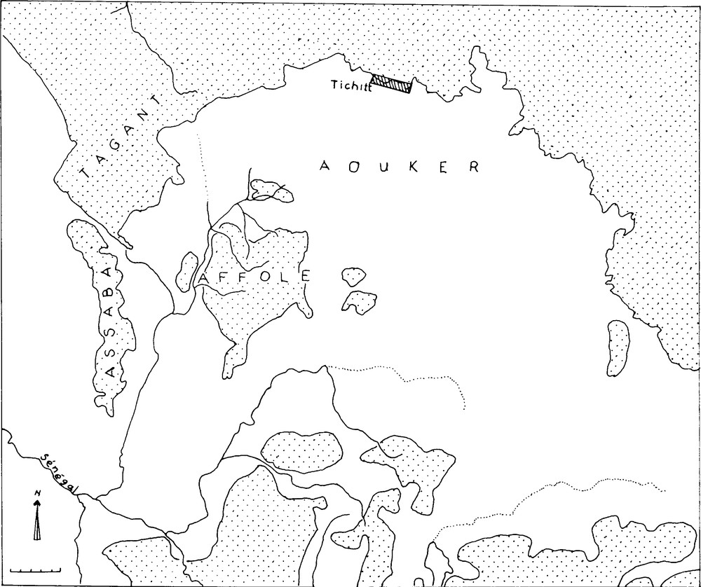
The Dhar Tichitt, located at 18° 20′–18° 27′ N and 9° 05′–9° 30′ W, is part of the sandstone cliff series of the South-Central part of Mauritania in southwestern Sahara (Fig. 1). The area was colonized by Neolithic agropastoral communities starting from ca. 4000 BP. They spread all along the sandstones cliffs and settled in the Dhar Tichitt, Dhar Walata, Dhar Nema, and beyond [1,5–7,12,13,15,20]. These groups settled on the cliff's top, along intermittent rivers courses, and interdunal depressions, herding cattle and sheep-goat, cultivating bulrush millet, hunting wild game, gathering wild grain and fruits, and fishing in the available ponds and lakes. The local Holocene climatic record points to a Humid Early Holocene (ca. 10,000–7000 BP) with relatively large size lakes in the Hodh. It was followed by an Mid-Holocene Arid phase (ca. 7000–5000 BP) during which most of the large lakes dried up and SW–NE oriented dunes were formed almost everywhere, except in the baten – cliff foot. A Mid-Holocene humid phase – also known as Nouakchottian – is documented to have taken place from ca. 5000 to 3000 BP [7–9,13,15]. It is during this period that the characteristic climatic pattern of two contrasted seasons, a more or less longer dry season and a generally shorter rainy season, appears to have developed. The later portion of the Late Holocene, particularly from 2500 BP on, was characterized by a shift toward increased aridity with successive drought episodes. These circumstances triggered the abandonment of the area for wetter regions in the south and east. How did Late Holocene people cope with the intrinsic unpredictability of climatic parameters such as seasonal variations, droughts, or flood during their more than 1500 years occupation of the area? This article, following the perspectives outlined in environmental archaeology research [7,13,16], tackles this issue through the lens of the Dhar Tichitt, Dhar Walata and Dhar Nema archaeological record and attempts to decipher the actual coping strategies devised by Neolithic agropastoralists. The emphasis was placed on methods and theory in the original formulation of an environmental archaeological approach to the evolution of past societies. In a recent shift, exemplified in this paper, the subdiscipline focuses more on results and the “relevance of these results for major themes and research problems” in archaeology and anthropology [13,16].
Location of the Dhars in southern Mauritania: from west to east, the Dhar Ousen, Dhar Tidjikja, Dhar Tichitt, Dhar Walata and Dhar Nema (Source: Google Earth).
Fig. 1. Localisation des Dhars dans la partie méridionale de la Mauritanie : de l’ouest à l’est, les Dhars Ousen, Tidjikja, Tichitt, Walata et Nema (Source : Google Earth).
2 Holocene environment
Palaeoclimatic research in ancient lacustrine deposits found in different parts of the Dhar Tichitt [7–9,15] has allowed a general reconstruction of the main outlines of the regional environment during the last 10,000 years. Three kinds of lakes have been documented all over the study area:
- • piedmont lakes set at the cliff foot on impervious sedimentary formations that collect rain water from their catchment basin (Fig. 2);
- • interdunal lakes created by both the rising water-tables and rainfall;
- • hydrographic lakes fed by local network of streams and rivers. There are nonetheless some intermediate kinds of lakes that combine piedmont and interdunal characteristics as is the case at Tichitt oasis and Khimiya further east.
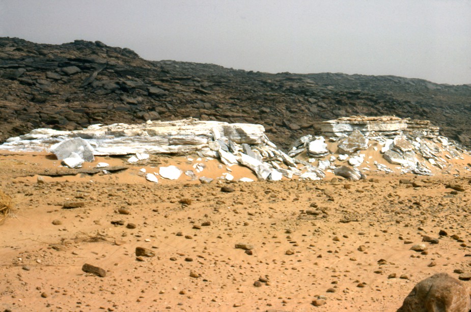
Diatoms deposit from the piedmont lake at the foot of Akhreijit Site cliff (Author's photo).
Fig. 2. Dépôt de diatomées du lac de piémont, au pied de la falaise du site d’Akhreijit (photo de l’auteur).
Evidence for a relatively large Early Holocene lake measuring approximately 100 km west-east was found between the Dhar Ousen (18° 20′ N and 10° 45′ W) in the west and the Dhar Tichitt (18° 20′ N and 8° 55′ W) in the east. The sandstone cliff was its northern shore but its southern limits have not yet been traced with precision [8,9]. With significant variations in size and depth, it lasted from ca. 9500 to 7000 BP. The diatoms flora consists above all of Melosira sp. in association with Cyclotella kutzingiana, C. ocellata, Cymbella gastroides and Rhopalodia parallela. Melosira is a planctonic species of deep and extended water bodies. Melosira italica is a northern alpine species and Cyclotella ocellata is a boreal one [17]. The climate was wet and cool with a more even distribution of rainfall. The large lake evolved into lagoons and was split into smaller independent lakelets.
All the lakes dried out during the Middle Holocene Arid phase (ca. 7000–5000 BP), a period that witnessed the accumulation and build up of very extensive and thick deposits of eolian sands.
Late Holocene interstratified clayey and sandy deposits point to a climate with contrasted seasons. Small lakes dotted the landscape surrounded by rings of high grass and trees as indicated by the high density of fossil roots (Fig. 2). The recorded diatomite flora is made of tropical epiphyte and littoral species such as Amphora ovalis, Epithemia argus, E. sorex, Navicula oblonga, N. Radiosa and Rhopalodia gibba. These species thrive in shallow water tending to brackish.
Additional evidence, from pollen analyses and faunal remains, was harnessed to achieve a higher resolution in the reconstruction of the main characteristics of the Dhar Tichitt Late Holocene environment. Most of the analyzed pollen samples were collected from contexts in direct association with archaeological remains. Gramineae, Cyperaceae and Chenopodiaceae/Amaranthaceae are largely predominant among non-arboreal pollen. The tree component is made of four species only: Acacia sp., Balanites egyptiaca, Capparidaceae sp. and Combretaceae sp. The pollen analyses point to a vegetation with an important grass and shrub stratum with scattered trees [7]. Animal bones on the other hand point to a broader ecotonal situation. Beside domestic animals, the faunal material reveals habitats ranging from fresh water lakes and streams to desertic environment. Fish [Lates niloticus], crocodile [Crocodylus niloticus], python [Python mollure] and Hippopotamus amphibious are from water habitats. Four species of large gazelles and antilopes living preferentially in woodland and grassland with regular water requirement are represented (Table 1, Figs. 3 and 4). Six species, including two carnivores, rhinoceros, equids, large gazelles, and large antilopes with varying water requirements live more often than not in a grassland and light bush environment. Animals that roam the desert and are resilient to water shortage are represented by the addax, small gazelles and Genetta genetta (Table 1). All these environmental indicators point to wetter climate than the present with, however, contrasting seasons [2,5–9,12,13].
Faunal remains arranged after preferential animals habitats.
Tableau 1 Restes fauniques présentés selon les habitats préférentiels des animaux.
| Taxa | Site 38 | Site 46 | General survey | DN4 |
| Domestic Animals | ||||
| Bos taurus | 35 | 5 | 32 | 139 |
| Ovis/capra | 12 | 2 | 14 | 5 |
| Water | ||||
| Fishes | – | 5 | 2 | 508 |
| Lates niloticus | – | 5 | - | + |
| Clarias sp. | – | – | 2 | + |
| Reptiles | ||||
| Crocodylus niloticus | – | 1 | – | 1 |
| Python mollure | – | – | 1a | – |
| Woodland and grassland: regular water requirements | ||||
| Hippopotamus amphibious | – | 2 | 7 | – |
| Hippotragus equinus | 2 | 6 | 5 | – |
| Phacochoerus aethiopicus | – | - | - | 3 |
| Kobus sp. | 2 | – | – | – |
| Tragelaphus sp. | 3 | 2 | – | – |
| Taurotragus derbianus | 5 | 2 | 5 | – |
| Grassland and light bush: varied water requirements | ||||
| Acinonyx jubatus | – | – | 1 | – |
| Ceratotherium simum | – | – | 1 | – |
| Equus sp. (asinus?) | 1 | 2 | 1 | – |
| Gazella dama | 3 | 2 | 5 | – |
| Oryx algazel | 11 | 5 | 6 | 5 |
| Redunca redunca | – | – | – | 2 |
| Panthera leo | 1 | – | – | – |
| Desert environment: resistant to water shortage | ||||
| Addax nasomaculatus | 9 | 4 | 3 | – |
| Gazella dorcas/Gazella sp. | 81 | 12 | 6 | 36 |
| Genetta genetta | 1 | – | – | – |
| Others | ||||
| Struthio camelus | – | 1 | – | 1 |
| Bovidae sp. | 45 | 21 | 18 | 63 |
| Cercopithecus aethiopicus | – | – | – | 1 |
| Cricetomys sp. | 1 | – | – | – |
| Mellivora capensis | 2 | – | 2 | – |
| Total | 214 | 77 | 111 | 764 |
a Skull and numerous vertebras in anatomic connection suggesting natural death.
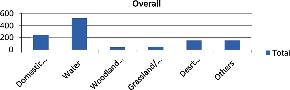
The general distribution of faunal remains according to animal habitats.
Fig. 3. Répartitions générales des restes fauniques, selon l’habitat des animaux.
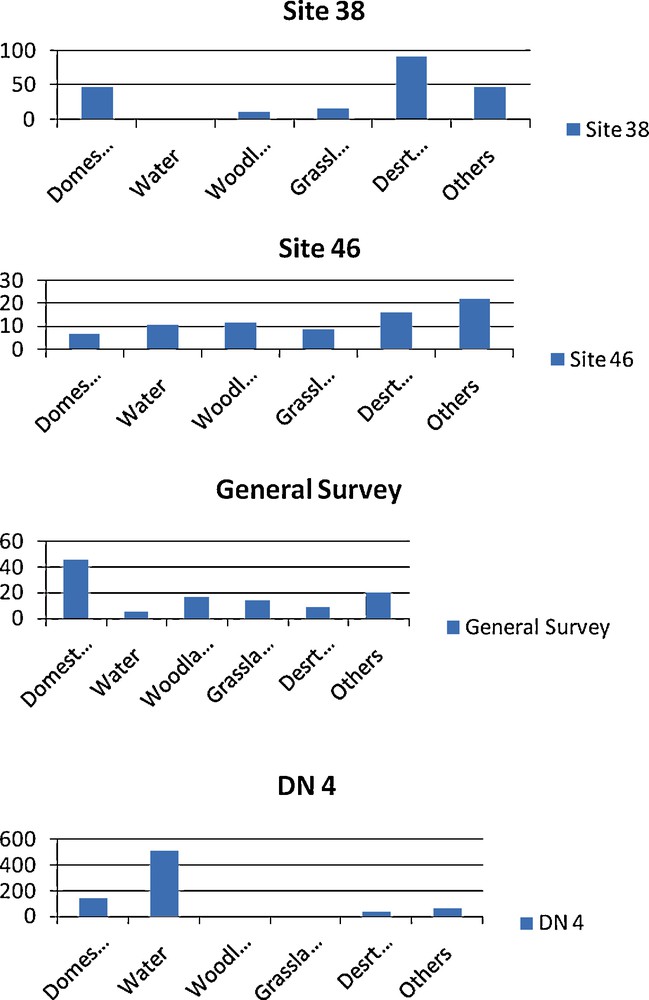
Variation in the distribution of faunal remains according to animal habitats as reflected in each sample.
Fig. 4. Variation dans la répartition des restes fauniques selon l’habitat des animaux, tel que le reflète chaque échantillon.
3 The Neolithic occupation of the Dhars
There are a few scattered stone tools, handaxes and flakes, assigned to the Early Stone Age [20]. All are surface finds difficult to interpret. There is no evidence of Late Stone Age occupation of the Dhars. Accordingly, there may have been an influx of new populations that had already mastered livestock husbandry of cattle and sheep/goat. These groups that were moving away from the drying Late Holocene Sahara found suitable environmental conditions in the Dhar Tichitt, Dhar Walata and Dhar Nema at the beginning of the second millennium BC [1–3,5–7,12,15]. These conditions, probably linked to the presence of high aquifers, monsoonal rains and vestigial lakes, allowed for the Neolithic occupation to take root and prosper. How did they cope with climatic uncertainty and what does this entail? The key element at this juncture was the presence of water. It could be obtained through rainfall, lakes, rivers, streams and springs. The positive fluctuations of the aquifers could also make life sustainable despite low rainfall level. In general, however, there may have been a combination of rainfall and water-table fluctuations to support Neolithic life in the Dhars. The timing, quantity and distribution of rainfall are some of the crucial variables in the sustainability of human life along the Saharan margins. They affect agriculture, livestock husbandry, as well as wildlife in general and in the absence of hydraulic engineering capabilities are in fact the controlling factors of human success or failure. The timing, distribution and quantity of rainfall are fundamentally unpredictable from one year to the next. How did Neolithic people from the Dhars handle these unpredictable variables? The Neolithic occupation of the Dhars lasted from ca. 2200 BC to 4/300 BC. Their sites were distributed in different ecological zones, in the sandy lowland, the front of the cliff escarpment, and the secondary and tertiary valleys of the hydrographic network (Figs. 5 and 6). The pace of settlement expansion will be dealt with later but at this stage suffices it to state that the occupations of all the regions ecological niches were contemporaneous (Fig. 7).
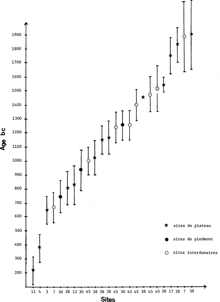
Radiocarbon chronology of the Dhar Tichitt settlements [7].
Fig. 5. Chronologie radiocarbone des peuplements du Dhar Tichitt [7].
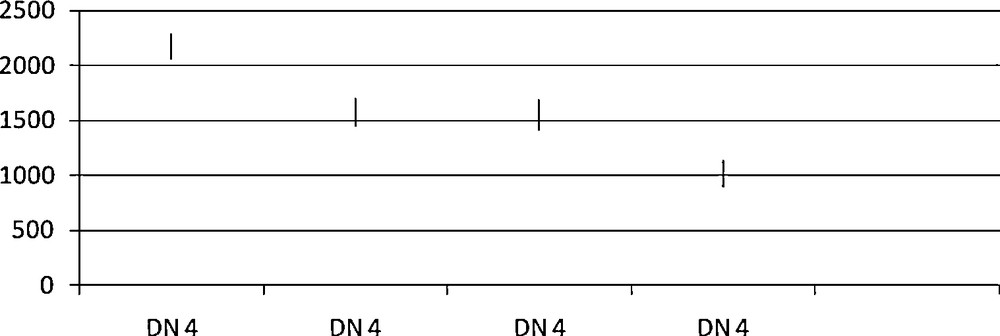
Radiocarbon chronology of the Neolithic occupation of Bou Khzama (Dhar Nema 4, Date BC).
Fig. 6. Chronologie radiocarbone de l’occupation néolithique de Bou Khzama (Dhar Nema 4, datation BC).
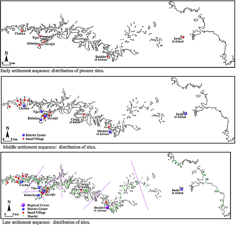
Patterns of settlement expansion in the Dhar Tichitt-Walata from ca. 2000 to 400 BC (Source: Holl 2004).
Fig. 7. Diagrammes d’expansion du peuplement dans le Dhar Tichitt-Walata ca. 2000 à 400 BC (d’après Holl 2004).
3.1 Intensification
Significant progress has been made in research on early West African agriculture [3–5,7,10,12,14,18,19]. But the genesis of West African grain farming is nonetheless still poorly understood in terms of the dynamic processes involved. Domesticated millet – Pennisetum glaucum – dated to the beginning of the second millennium BC has been found in the Dhar Tichitt [12], Dhar Walata in Mauritania [3] and the “Kintampo” site of Birimu in North-Central Ghana [19]. A second wave of evidence pointing to the cultivation of domesticated millet dating to the turn of the first millennium BC has been documented at such places as Oursi in Burkina Faso, Gajiganna in Nigeria [14], suggesting a wide spread adoption of millet that reached the rainforest and East Africa during the first millennium BC. Domesticated African rice, Oriza glaberrima, is attested at Jenne-Jeno in the second half of the first millennium BC. The concept of intensification refers to a range of strategies aimed at securing a stable and reliable resources supply. It has two divergent implications. In one set of strategies, sustainability would be achieved through the broadening of collected resources – stretching the diet-breadth in both plant and animal resources. The other strategies set operate on a narrow range of resources that experience a strong and sustained exploitation pressure. In a co-evolving conundrum, the selected plant or animal went through a cascade of directional change that alters some of their characteristics; non-shattering and in the longer run larger grain for wild Pennisetum for example, or reduced body-size for some mammals.
The Dhar Tichitt has been hailed as an interesting case of local intensification that resulted in the domestication of wild millet. Relying on P. Munson [12,13], Stemler [18] offers the most coherent rendering of the intensification theory. Starting with a question, she wonders if it is “possible that it was the adoption of herding and the extensive use of wild grain that initiated the population growth indicated in the archaeological record at Dhar Tichitt?” She then moves on to argue that “if so, this change in the economy may have resulted in the necessity for increasingly labor-intensive practices to provide sufficient food for a growing population”, and concludes that “this trend eventually resulted in the highly intensive interaction between plants and people that we call agriculture” [18]. From this perspective, bulrush millet was part of a cohort of wild plants that included Cenchrus biflorus (cram cram), Brachiaria deflexa, Panicum turgidum, P. laetum, exploited by Akhreijit Phase (ca. 1750 BC) foragers. The shifting frequencies of different species culminating in a 61% proportion of bulrush millet impressions in potsherds from the Chebka phase (ca. 1000–900 BC) is supposed to illustrate the gradual domestication of this species and the shift to the practice of agriculture. The domesticated millet from Oued Chebbi in the Dhar Walata dated to the beginning of the second millennium BC [1–3] shed serious doubt on the gradualist model alluded to above and makes it very unlikely. There is not yet any convincing evidence for the presence of Late Holocene mobile foragers settlements in the Dhars. The domestication of Pennisetum glaucum was probably an unanticipated result of semi-nomadic herders exploitation of local resources. Contrary to the other equally exploited wild plants, wild Pennisetum adjusted to the regular and sustained exploitation by both humans and livestock. This adjustment resulted in the growth of non-shattering large grain varieties that became humans staple food. Despite the sustained presence of Pennisetum glaucum remains in the Dhar Tichitt and Dhar Walata archaeological record, the importance of this grain in Neolithic people diets cannot be assessed accurately. Plants macroremains frequencies obtained from impressions on pot-sherds cannot be translated directly into patterns of past humans diets.
3.2 Seasonality
No evidence of hydraulic engineering – like well, cistern and other water storage devices – has yet been documented in the Dhars’ archaeological record. Neolithic people certainly relied on springs, rain and surface water that were available and availability was very likely strongly constrained by seasonal variations. Accordingly, one may well be founded to consider that the landscape was lush green; springs and streams were flowing, and lakes full of water during the rainy seasons. This overall availability of water was altered progressively with the onset of the long dry season. Some streams may have dried up faster than others, and at the peak of the dry seasons, a limited number of places may still have had some water available. Such places were generally found around piedmont and interdunal lakes where the water-table allowed for the year-round availability of water. Such places were focal areas for settlement during the dry seasons, and many, like Ngoungou (Site 45) in the Dhar Tichitt and Bou Khzama (DN 4) in the Dhar Nema were used intermittently for the whole duration of the Dhars Neolithic occupation [5–7,16]. Bou Khzama, located in the Dhar Nema at 16° 44′ 20″ N and 7° 16′ 26″ W, is an extensive surface site spread over tens of hectares. It sits on a stabilized dune at some 200 m west of the cliff escarpment. The site was sampled and excavated in 2001 and 2002 by a team led by A. Person [15]. The excavated unit measured 140 m2 and revealed a number of archaeological features including hearths, burials, pits, stone caches, iron smelting furnaces, slag heaps, etc. The site is clearly a palimpsest that resulted from intermittent and successive occupations over more than three millennia, from ca. 2280–2060 BC to 1220–1380 AD (Fig. 6). Bou Khzama, located next to the mouth of a seasonal stream, was very likely used as dry season camping area by groups of herders, hunters, fishermen during the Neolithic occupation and later by iron-using communities at the time of the Ghana kingdom.
Faced with a predictable dry season water shortage, the Dhars Neolithic people devised a robust strategy to enhance their livelihood, a short range and pulsatory nomadism. Water sources were most of the time at a “walking” distance range. Groups could have walked up to 5–10 km to fetch water in large clay vessels or “goat-skins”, to be kept in large storage jars in the “household compound”. Groups of herders probably took livestock herds to dry season camping areas for most of the duration of the dry season. They left their traces in the archaeological record in the form of shallow scatters of food waste, broken sherds and grain processing stone tools [5–7]. Following this rationale, the sites located on the cliff, all built with dry stone masonry, were permanent villages of more or less linked communities. Dry season camps on the other hand, all aggregation points located in the sandy lowland, may have shifted from place to place following the pace of drying of surface water. Some of these sites with longer lasting and reliable water supply were resettled years after years. With the onset of the summer rains – June-July – the dispersed groups of herders moved back to their respective villages, pen the livestock in large corrals and shift to the preparation of the fields for the millet growing season. The combination of hunting, fishing, livestock husbandry, agriculture, as well as other crafts including pottery, stone tools making, etc., exerted a considerable demand on households’ labor pools. How did these societies handle these conflicting schedules?
4 The dynamics of agropastoral economy, site layout and household structure
Mixed agropastoral economies combine in varying degree, agricultural activities, livestock husbandry, hunting, fishing, wild plants gathering and many other crafts. In the yearly cycle and depending on climatic parameters, all the activities mentioned above have period of low and high labor demands. The scheduling of productive activities and the corollary allocation of labor require well-tested social mechanism to cope with life during the Late Holocene in the Dhars regions of Mauritania and elsewhere. Alliance building, household structure and patterns of inheritance are such mechanisms that operate more or less as labor recruitment and retention devices. The multiplicity of simultaneous and/or successive tasks required for the smooth operation of mixed agropastoral economy can hardly be handled by a nuclear family. Cooperation along task-specific groupings and/or age-sets could help households navigate acute labor shortage and activities bottlenecks. They are however difficult to document in the archaeological record. Nonetheless, habitation features from permanent villages provide a number of clues on the solutions devised by Neolithic settlers of the Dhars during the Late Holocene. While dry season sites were characterized by scattered surface remains, permanent villages located on the cliff point to a heavy investment in habitation facilities construction. The standard Neolithic household unit – a compound – part of an intricate village layout including narrow streets and open plazas was delineated by a dry-stone wall, surrounding a number of dwelling units and storage areas. In most of the cases, each unit had a single hearth and one or many storage areas and was part of a cluster of connected compounds, those sharing walls. The number of dwelling units per compounds that varies from two to nine at Akhreijit where a systematic inquiry was conducted. It suggests that each of the compounds was inhabited by a multicellular family unit, an extended or polygamous family [6,7]. Such social units allow for an optimal recruitment, retention and allocation of labor and at the same time enhance the status of those able to attract a large following. In this perspective, wealth and prestige are materialized by the number of dependents.
4.1 Patterns of settlement
The reconstitution of the main patterns of the expansion of settlement in the Dhar Tichitt-Walata is partly inferential as a limited number of sites have been excavated and dated. The new research on the Dhar Nema [15] is not yet fully published. Research on the Dhar Tichitt settlement sequences [5–7] was instrumental in developing this model (Fig. 7). Large villages and large dry season camps, measuring more than 5 hectares, were all settled from the very beginning of the Dhars Neolithic occupation around ca. 2200–2000 BC. The settlement probably started with a small number of settlers. They were distributed in three main “clusters” set at 40–50 km. The western part of the Dhar Tichitt had a higher density of settlement right from the beginning. Population growth was relatively slow as the Early Settlement Sequence lasted for more than 1000 years, from ca. 2200/2000 BC to 1200/1000 BC. The location of all the pioneer sites was optimal, along the escarpment and at the intersection of the sandy lowland and the cliff top. Significant population growth and the foundation of new smaller villages took place mostly in the western confines of the Dhar Tichitt with however a new settlement at Chegg el Khail in the central part during the Middle Settlement Sequence ca. 1200/1000–700 BC (Fig. 7). The distance between sites groups was then reduced to 20 km in the Dhar Tichitt. Small villages and hamlets spread all over the landscape, precisely along the secondary and tertiary valleys, during the Late Settlement Sequence ca. 700–400 BC. All of this growth took place in the central and eastern part of the Dhar Tichitt-Walata. Subregional clusters of settlements with one large central village, a few small villages and numerous hamlets emerged during this sequence. Dakhlet el Atrouss, at the center of the study area, reached 95 hectares in surface extent. Chebka, Akhreijit and Khimiya in the west were protected by a perimeter wall. The average territory per settlement dropped from 466.66 km2 in the Early Settlement Sequence to 31.11 km2 in the Late one. Competition for land may have triggered conflict in the west. The colonization of the cliff top helped to alleviate the pressure on land and resources of the optimal zone where evidence of conflict is manifest by the presence of perimeter walls.
5 Conclusion
The details on the initial colonization of the Dhars are not known. But it is nonetheless clear that groups of cattle and sheep/goat herders settled along the sandstone cliffs at the end of the third millennium BC. They devised successful strategies to cope with the overall unpredictability of the climatic parameters. Through sustained intensification, short range and pulsatory nomadism, and colonization they succeeded in building the earliest extensive village communities of West Africa. The middle of the first millennium BC witnessed the onset of an acute arid phase that precipitated the disaggregation of the Neolithic agropastoral occupation of the Dhars. The abandonment of the whole area was probably gradual with small groups of families moving south and southeast in search for better environments. These populations may have later contributed to the rise of the Ghana Empire. The earliest settlers of Awdaghost were mobile herders [11]. Iron smelters settled in the Dhar Nema [15]. The fluctuations in the level of Awdaghost aquifers, as indicated by the increasing depth of wells from ca. 500–600 AD to 1500 AD (Fig. 8), attest to the continuation of long-term climate change that started at the end of the 1st millennium BC. The disruption of the Dhars water cycle put an end to the most successful prehistoric agropastoral economies of West Africa.
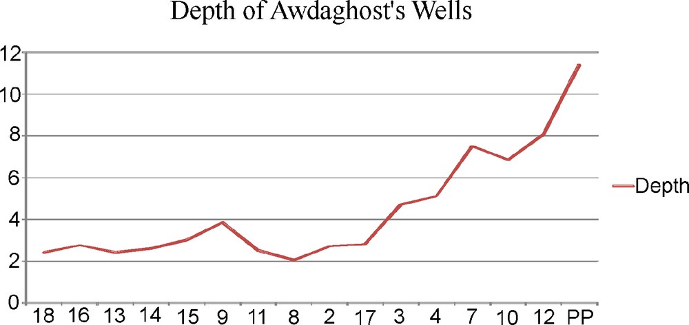
Fluctuations of the Awdaghost aquifers as shown by increasing/decreasing well's depth, from ca. 400/600 to 1500 AD.
Fig. 8. Fluctuation des aquifères d’Awdaghost telles que les montre la profondeur croissante/décroissante des puits, de ca. 400/600 à 1500 AD.
Acknowledgements
I wish to thank Professor S. Cleuziou and Dr. A-M. Lezine for their invitation to write and present this paper. My research in the Dhar Tichitt was funded by a grant of the French Ministry of Cooperation to Professor Henry-Jean Hugot. I am grateful to Dr. Raymonde Bonnefille for her support and training in pollen analysis and Dr. F. Poplin for training in faunal analysis. Kay Clahassey from the University of Michigan Museum of Anthropology helped with the figures.