

1 Introduction
The Puy de Dôme volcano, 500 m high with a basal diameter of c. 1500 m, is the largest volcanic edifice of the Chaîne des Puys (Fig. 1). It is a trachytic dome, composed of two distinct morphological units which have been interpreted as two interlocked edifices (Boivin et al., 2009; Camus, 1975). Westwards, it shows a rocky mass with steep slopes, marked by radial ridges and punctuated by small pinnacles characteristic of bristled lava domes. The topography becomes smoother down the western slopes by the accumulation of pyroclastites, either in a primary position or derived from later erosion. This occidental unit is considered as a remnant of the primitive volcano. Eastwards, the mountain looks like a steady, not rugged cone hiding a second dome beneath a mantle of pyroclastites. The second dome erected in the eastern sector of the first one, opened by flank collapse (Boivin et al., 2009; Camus, 1975).
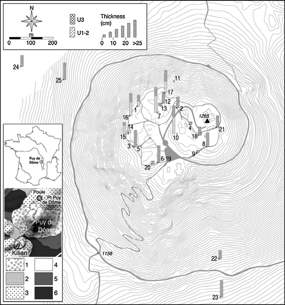
Map of Puy de Dôme volcano and localization of the sections (numbered 1 to 25) where the Chemin de Ronde tephra (CR) was observed. Bars on the main figure indicate the thickness of the U3 upper CR unit and the total thickness for U1 and U2 units. Buildings, paths and roads are in light grey. The distance between contour lines is 5 m. Geological map: 1: trachytic breccias; 2: ashfall; 3: Strombolian cone (the northern one is Petit Puy de Dôme); 4: trachyte; 5: trachybasaltic lava flow; 6: basaltic lava flow. For details, see Boivin et al., 2009.
Carte du Puy de Dôme avec localisation des affleurements (numéros 1 à 25) où a été observée la formation du Chemin de Ronde (CR). Les cartouches donnent l’épaisseur de l’unité supérieure U3 et de l’ensemble U1–U2. Routes et constructions sont en gris clair. Les lignes de niveau sont équidistantes de 5 m. Légende de la carte géologique : 1 : brèche trachytique ; 2 : retombée cendreuse ; 3 : cône strombolien (celui du nord est le Petit Puy de Dôme) ; 4 : trachyte ; 5 : coulée trachy-basaltique ; 6 : coulée basaltique. Détails dans Boivin et al., 2009.
The lava is a light-grey trachyte, macroscopically characterised by the occurrence of biotite, green pyroxene in some facies, potassic oligoclase and sanidine phenocrysts. However, it displays variable features (colour, texture, density…). It does not include visible allogeneous elements, except for some scarce and small enclaves of less differentiated lava (Arnaud et al., 1992).
The total duration of volcano building has probably not been longer than a few decades, as suggested by the scenario at Montagne Pelée (French West Indies) where, in less than 30 years, a new dome (1929–1932) terminated by a high pinnacle, rose in the previous half destroyed dome of 1902–1903 (Lacroix, 1904; Perret, 1937). It is also suggested by the on-going dome-forming eruption at Soufrière Hills, Montserrat (Sparks and Young, 2002). Such a time interval is significantly shorter than the age uncertainties on the Puy de Dôme volcano (Table 1). Combination of the age data with a Bayesian approach including radiocarbon calibration (see the method in Lanos, 2004; Sapin et al., 2008), resulted in an age distribution, which, for sake of clarity, was summarized as a single age: 11,040 ± 230 y (2σ, as quoted for all age data in the paper). This age is in agreement with that of the pollen suite extracted from peat embedding a distal thin layer of Puy de Dôme tephra, which belongs to the transition Dryas/pre-Boreal (Juvigné and Gewelt, 1987).
Résumé des résultats de datation pour le dôme et pour la formation CR.
| Sample | Sample location | Dating laboratory | Reference | Method | Age result |
| Dome | |||||
| Feldspar from massive lava | Top of PdD | LPC | Faïn et al., 1991 | TL | 9.7 ± 1.0 ka |
| Zircon from massive lava | Top of PdD | LPC | Faïn et al., 1988 | TL | 10.8 ± 1.0 ka |
| Minerals from massive lava | Top of PdD | LMV | Condomines, 1997 | U-Th | 12 ± 1 ka* |
| Peat embedding trachytic ashes | Ampoix maar (20 km S of PdD) |
CEN Mol | MBN 325 (Juvigné and Gewelt, 1987) | 14C | 9,790 ± 175 BP |
| Carbonized plant remains | Bottom of block-and-ash flow deposits at the E foot of PdD | CDRC Lyon (AMS at Groningen) |
Lyon-5222 (GrA) | 14C (AMS) |
9,615 ± 45 BP |
| CR | |||||
| Carbonized plant remains | Top of PdD, beneath unit U2 | CDRC Lyon (AMS at Poznan) |
Lyon-3334(Poz) | 14C (AMS) |
9,370 ± 55 BP |
| Carbonized plant remains | W flank of the PdD, bulk of unit U3 | CDRC Lyon (AMS at Oxford) |
Lyon-3999 (OxA) | 14C (AMS) |
9,460 ± 40 BP |
* Crystallization might have occurred a few centuries before eruption (Condomines, 1997). Uncertainties quoted at 1 sigma.
Furthermore, the Puy de Dôme volcano is older than the Cratère Kilian, a trachytic volcano located at its southwestern foot (Fig. 1), as material emitted by the Kilian partly overlaps Puy de Dôme products. Kilian age is established at 9,430 ± 120 y by four distinct 14C measurements (compilation in Miallier et al., 2004). Besides, the soil developed atop the Puy de Dôme volcano before the Kilian eruption contains a pollen suite characteristic of the beginning of the Boreal period (Raynal et al., 1998).
Between 2004 and 2008, new exposures were observed on Puy de Dôme summit and a previously unknown pyroclastic sequence has been identified. It is intercalated between the Puy de Dôme s.s. products and the Kilian tephra. The present article describes this pyroclastic sequence hereafter referred to as the « Chemin de Ronde sequence » (CR) and gives a volcanological interpretation for it.
2 Tephrostratigraphy on Puy de Dôme volcano
2.1 Main features
The upper part of the volcano, above 1430 m a.s.l., is approximately conic, with the same centre as the so-called second dome, about 250 m eastwards of the mountain main axis. Its topography has been deeply modified by human activity. Westwards and south-westwards, the best preserved half-crowned zone, between 1400 m and 1430 m a.s.l., has a hillock relief.
Occasional exposures suggest that the original surface of the dome was rather rough. Wherever the massive rocky lava can be observed, it displays a chaotic aspect. It is locally affected by small fissures through which fumaroles circulated, altering the lava and leaving red, yellow or black staining and hematite crystallizations. Where it does not crop out, the actual surface of the dome is coated by white, grey or yellowish unbedded ashes wrapping massive trachytic blocks of various size. The CR unit, when present, rests on the above-described surface (Figs. 2 and 3). A dark brown andosol (analysis in Raynal et al., 1998) developed at the expense of the underlying loose material, possibly the CR unit. The Kilian deposits, about 1 m thick although with significant local variations, cover this palaeosol. These deposits consist of two distinct units separated by a bed of vesiculed tuff (Fig. 2). Both units have a polylithologic composition, with both trachytic and xenoclastic elements. The Kilian trachyte is macroscopically distinguished from the Puy de Dôme trachyte by its low biotite content and the presence of brown amphibole needles. It occurs either as expanded, vesiculated fragments, or as dense bombs that are sometimes quenched and bread-crust like. The palaeosol beneath the Kilian formation has been impacted by the pyroclastites and includes bomb sags.

Exposure views. a: section #3; b: section #16; c: section #1 (localization: see Fig. 1). U1 and U2: CR units. U1: pyroclastic surge deposits, mainly composed of older dome trachyte, previously altered by fumarolization. U2: pyroclastic surge deposits, mainly composed of unaltered trachyte. U3: pyroclastic surge consisting of a reddish-brown layer of dome altered lapilli mixed with a significant amount of country lithics in a fine-grained matrix. A soil developed in the upper part of U3 before deposition of the Kilian pyroclasts.
Photos d’affleurements. a : coupe 3 ; b : coupe 16 ; c : coupe 1 (localisation : cf. Fig. 1). U1 et U2 : unités de la formation CR. U1 : dépôts de déferlante, essentiellement composés de trachyte de l’ancien dôme altéré avant dépôt par fumerollisation. U2 : dépôts de déferlante composés principalement de trachyte sain ; U3 : dépôt de déferlante brun-rouge, composé de lapilli trachytiques altérés mélangés avec une proportion importante de lithiques allogènes, dans une matrice fine. Un sol s’est développé dans la partie supérieure de U3 avant le dépôt des produits du Kilian.
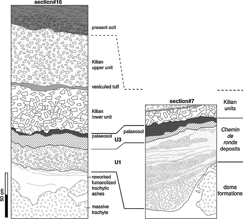
Synthetic cross sections #16 and #7 (for details, see Fig. 2 caption).
Synthèse des coupes 16 et 7 (détails dans la légende de la Fig. 2).
2.2 The CR pyroclastic sequence
The sequence displays three distinct units (U1-3), although in many places it is represented only by the upper one, U3 (Figs. 2 and 3).
U1 is composed of blunt trachytic lapilli, multi-coloured or uniformly light grey, poorly bedded or clearly bedded (Fig. 4 and Table 2). The trachytic granules macroscopically look very similar to those of the Puy de Dôme trachyte. They are generally altered, with biotite exhibiting high temperature alteration and strong discolouration. U2 (site #1, Fig. 1 and Fig. 2c) is composed of light grey angular trachytic lapilli, seemingly unaltered. These lapilli are trachytic in composition. This composition is similar to that of the Puy de Dôme trachyte, but with a slightly lower Si content, and significant differences in trace element contents (to be published). The thinner fractions of U2 include a significant amount (∼ 10 vol. %) of allogeneous rocks and minerals (Table 2).
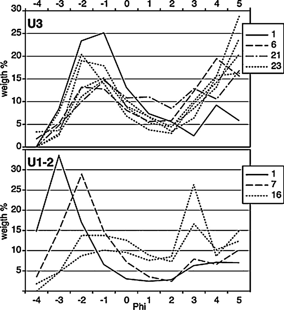
Grain-size distribution in units U1-2 and U3. Numbers in the caption refer to those of sampled sections (Fig. 1).
Courbes granulométriques pour les unités U1-2 (ensemble) et U3. Les numéros dans les cartouches renvoient à ceux des coupes échantillonnées (Fig. 1).
Description simplifiée des trois unités de la formation CR. Toutes les trois ont une distribution granulométrique bimodale (Fig. 4).
| Unit | Thickness (cm) | Composition | |
| Grain size > 2 mm | Grain size ≤ 2 mm | ||
| U1 | 20–120 | Trachytic altered lapilli | Trachytic altered lapilli. Free biotite and feldspar crystals |
| U2 | 10 | Trachytic unaltered lapilli | Trachytic unaltered lapilli (∼ 87 vol. %), free minerals (biotite, feldspar, quartz) and allogeneous lithics (country rocks, clinker fragments, mafic lavas) |
| U3 | 5–30 | Trachytic altered lapilli | Trachytic altered lapilli (40-70 vol. %), free minerals (biotite, feldspar, quartz) and allogeneous lithics (country rocks, clinker fragments, mafic lavas). Carbonized plant remains (only on the flanks of the volcano) |
U3 is a reddish-brown layer of multi-coloured lapilli embedded in a matrix. The upper part of U3 includes the dark-brown palaeosol which was covered by the Kilian pyroclasts. U3 composition depends on the grain size and sampling location. It typically consists of altered Puy de Dôme-like trachytic lapilli in the larger grain-size fractions and a mixture of such lapilli with allogeneous rocks and minerals (∼ 5–15 vol. %) in the thinner fractions (Table 2).
Locally, atop the Puy de Dôme volcano, the basis of the CR sequence (there only represented by U2 and U3) is darkened over a few millimetres by vegetal ashes where Pinus sp. was identified (Erwan Messager and Aurélie Salavert, Muséum National d’Histoire Naturelle, Paris, personal communication, 2009).
2.3 Spatial distribution of the CR pyroclastic sequence
Units U1 and U2 were only observed in the central and western parts of Puy de Dôme summit, whereas U3 was observed all over the summit. The maximum thickness of the whole CR sequence is encountered in the central and western parts (Fig. 1).
Gully erosion of the western flank of Puy de Dôme volcano (between sites #24 and #25 on Fig. 1) enabled to observe the local stratigraphy. The volcanic unit at the basis of the outcrop was unknown. This layer, with a mean slope of ∼27°, consists of unsorted red scoriae embedding bombs, several centimetres to more than two metres in size. Their potassic trachybasaltic composition is very common among the Chaîne des Puys lavas. It is interpreted as the flank of an older Strombolian cone (called Corneboeufs). The cone slope is either covered by trachytic blocks, lapilli and ashes from the Puy de Dôme s.s., or by the CR deposits represented only by U3. The contact is underlined by a mixture of red scoriae and trachytic ashes and lapilli.
Despite systematic exploration of the other flanks of Puy de Dôme volcano, unit U3 was only observed at the bottom of the southern slope where it reaches more than 30 cm, between the Kilian and the Puy de Dôme units (#22 and #23, Fig. 1).
The total volume of the CR tephra (U1-3) is estimated at 15,000–25,000 m3, which is less than 0.01 vol. % of the whole Puy de Dôme products.
2.4 Chronology
Carbonized plant remains sampled beneath the CR sequence on the volcano summit (section #1, Fig. 1) and in the U3 unit on the western slope (section #25, Fig. 1) were dated by the 14C (AMS) method at 9,370 ± 55 BP (Lyon-3334 (Poz)) and 9,460 ± 40 BP (Lyon-3999 (OxA)), respectively. Calibration and combination of the two results indicate that the late eruption of Puy de Dôme volcano occurred 10,700 ± 100 (2 σ) years ago (method in Juvigné and Gewelt, 1987; Miallier et al., 2004). The difference between this age and that of Puy de Dôme s.s. (i.e., 11,040 ± 230 y) cannot be precisely assessed. However, the statistical analysis of the data suggests that the time interval was longer than 120 y at the 95% confidence level (method in Lanos, 2004; Sapin et al., 2008).
On the other hand, the development of vegetation atop the fresh lava dome must have required at least several years. In the current local climatic conditions, young trees such as pines would appear at the naked surface of a quarry 5 to 10 years after clearing (Tort, 1999). Also, reestablishment of trees on Mount St. Helens pyroclastic flows, in similar climate conditions, took about 15 years (Dale and Adams, 2003). So, both arguments (dating and vegetation recover) indicate that the ultimate eruption of the Puy de Dôme volcano occurred after a significant repose period.
3 Discussion
Limited opportunities to observe the subsurface of the Puy de Dôme volcano hindered detailed study of the CR formation. Delineating isopach curves was impossible because of: (1) the important lateral variations of thickness and structure of the deposits; and (2) the dispersion of the observation sites. However, the new data allow assessing new conclusions on the Puy de Dôme volcano building stages.
The proposed sequence began by the explosive aperture of a vent through the dome. During this phase, the bulk of the dome, largely altered by fumaroles, was grinded and expulsed as pyroclastic surges, producing U1 deposits. This assumption is supported by the bimodal grain-size distribution (Cas and Wright, 1987) and the unconformity of the lapilli beds (see section #7, Fig. 3). Then, deeper explosions ejected magma lapilli accompanied by substratum lithics, producing U2. The occurrence of carbonized plant remains beneath layer U2 (section #1, Fig. 1) indicates that its deposition temperature was higher than 250 °C (Babrauskas, 2002). Finally, superheated water generated phreatic explosions initiated beneath the dome, producing U3 deposits with a significant fine-grained component containing lithics and country rocks. U3 also represents the most extensive eruptive phase of the CR sequence.
Phreatism as an amplifying mechanism for eruptions is common in the immediate vicinity of the Puy de Dôme volcano, with examples at Kilian and La Poule (Fig. 1). Recent deep drillings devoted to water resource exploration suggest the existence of a palaeothalweg able to channel water beneath Puy de Dôme volcano (Boivin et al., 2009). On the other hand, water storage by the Puy de Dôme lava itself is significant because of its high porosity, 18–23 vol. % (Kieffer and Lautridou, 1975). Such water might have played a role in the development of phreatic explosions. The magma component of U2 may be a juvenile magma which triggered real phreatomagmatic eruptions. Alternatively, it may originate from a dyke intrusion contemporaneous of the dome formation, which did not reach the surface, and remained hot decades later. Indeed, the high temperature emplacement of CR, attested by the occurrence of charred plant remains, favours the phreatomagmatic assumption but U2 trachytic lapilli look like dome fragments without typical juvenile magma features, such as pumice or quenched textures.
Such late eruption dynamics requires the existence of a crater. None has yet been identified, but the spatial distribution of CR suggests that it should have been close to the centre of the Puy de Dôme summit. Unfortunately, this area has been deeply remodelled for road and car park construction. The twofold dome implies the existence of a north-south discontinuity between the two structural (East and West) units. This is also suggested by a series of small depressions on the dome summit (see geological map in Boivin et al., 2009, simplified on Fig. 1). Additionally, fissural volcanism is represented around the Puy de Dôme volcano by the aligned craters of the Petit Puy de Dôme and the elongated one of the Kilian (Fig. 1). Actually, the whole Chaîne des Puys is cut by numerous faults, roughly oriented north-south (Boivin et al., 2009), which have controlled the location, and sometimes the orientation, of volcanic centres as in the Westeifel volcanic field (Mertes and Schmincke, 1985). Thus, it is likely that a north-south discontinuity in the dome may have favoured the CR explosive eruption.
Well-known active volcanoes, although situated in different settings, allow comparisons. The suggested crater of Puy de Dôme volcano was probably not ring-shaped as for Santiaguito dome in Guatemala (Bluth and Rose, 2004), but like a fracture. Similar fractures, either new or reactivated ancient ones, allowed the development of five phreatic eruptions atop the Soufrière lava dome (Guadeloupe) between the 17th and 20th centuries (Feuillard et al., 1983; Jolivet, 1958; Vincent et al., 1979). For example, the minor 1690 AD eruption occurred about 160 y after the major magmatic eruption which produced the dome, at c.1530 AD (Boudon et al., 2008). These eruptions were initiated by vent clearing and most of the emitted material was not fresh magma.
4 Conclusions
The initial construction of the Puy de Dôme volcano was, at a much smaller scale, comparable to that of recent major lava domes, such as Mt. St Helens (Voight et al., 1983) or Soufrière Hills at Montserrat (Sparks and Young, 2002), with sector collapse and block-and-ash pyroclastic flows. However, the summit and flanks of Puy de Dôme volcano are locally covered by a small volume pyroclastic sequence, intercalated between the dome and Kilian deposits. The related eruption must have been comparable to the minor and delayed phreatic/phreatomagmatic eruptions of the Soufrière (Guadeloupe), which took place between the 17th and 20th centuries. This Puy de Dôme late summit eruption, 10,700 y old, occurred in three stages: (1) explosive aperture of a vent through the bulk of the dome and emplacement of pyroclastic surges; (2) phreatomagmatic expulsion of fresh magma; and (3) final phreatic explosion initiated in the substratum below the dome.
The late eruption of Puy de Dôme volcano may be considered as an example of a delayed phreatic/phreatomagmatic summit activity occurring after the dome growing stage of a small intraplate lava dome. It outlines that such dynamism is not limited to major complex lava domes.
Acknowledgements
The Conseil Général du Département du Puy-de-Dôme allowed us to follow the works and excavations performed atop the Puy de Dôme volcano between 2005 and 2008. Daniel Parent (Institut national de recherches en archéologie préventive) kindly allowed us to investigate the mechanized soundings made under his control. E. Messager and A. Salavert (IPH, Paris) kindly examined the carbonized plant remains.