

1 Introduction
Debris flows consist of fully saturated mixtures of water, sediment and debris that can travel, in a series of surges, several kilometers in mountainous torrents or open hillslopes (Iverson, 1997). They are recognized as one of the dominant geomorphic processes in steep mountainous terrain (Corominas et al., 1996; Hungr et al., 2001; Scott et al., 1995; Takahashi, 2007; VanDine and Bovis, 2002). They are usually triggered by intense and localized thunderstorms (Fan et al., 2003; Godt and Coe, 2007; Johnson and Sitar, 1990) and may constitute a dangerous natural hazard for inhabitants and infrastructures downslope (Coeur and Lang, 2008; Naiman et al., 2008). Knowledge of debris-flow processes was substantially improved over the last 30 years; nevertheless, little is known about entrainment processes (e.g. scouring) during the runout of the debris flow (Cenderelli and Kite, 1998; Coe et al., 2008; Jakob et al., 2000; Remaître et al., 2008; Rickenmann et al., 2003).
In clay-shale watersheds affected by strong erosion, slopes can provide a large quantity of materials to the torrent (Grandjean et al., 2009; Hungr et al., 2005; Malet et al., 2005; Maquaire et al., 2002, 2003). The scoured sediments may change the behaviour of the debris flow during the runout. Geomorphologic observations associated to laboratory tests (grain-size distribution, petrography, and rheology) are of primary interest in order to locate the most prone scouring areas and describe the erosion processes.
In the early evening of 5 August 2003, a large debris flow occurred at the Faucon torrent located in the Barcelonnette Basin (South French Alps). This debris flow caused substantial damage on several buildings located on the torrential fan. This paper presents some morphological aspects of the debris-flow event through a careful field survey and a characterization of the transported sediment.
2 Study area
2.1 The Barcelonnette Basin
The Barcelonnette basin is a steep forested basin, which extends from 1100 to 3000 m a.s.l. (Fig. 1). It is representative of lithological, geomorphological, climatic and landuse conditions observed in the South French Alps.
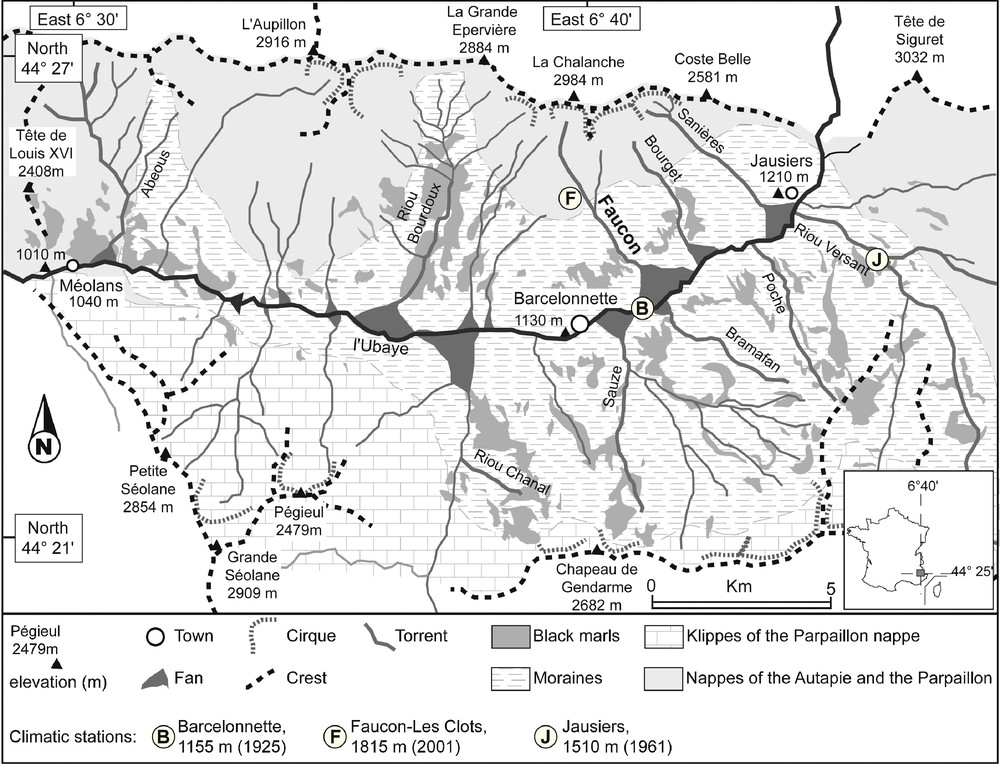
Morphological sketch of the Barcelonnette Basin (South French Alps).
Carte géomorphologique simplifiée du Bassin de Barcelonnette (Alpes-de-Haute-Provence).
The basin is located in the dry intra-Alpine zone, characterized by:
- • a mountain climate with a marked interannual rainfall variability (735 ± 400 mm over the period 1928–2005) and 130 days of freezing per year;
- • a continental influence with significant daily thermal amplitudes (> 20 °C);
- • a Mediterranean influence with summer rainstorms yielding more than 50 mm.h−1 on occasion (Maquaire et al., 2003). The basin is drained by the Ubaye River.
Hillslopes are characterized by a specific morphology (Fig. 2):
- • at the upper parts (1900 to 3000 m a.s.l.), slopes are steeper than 45° and consist of nappes made of calcareous sandstones. These slopes are often covered by non-consolidated debris varying in thickness between 0.5 to 5.0 m. Several debris tracks are affecting these slopes;
- • at the lower parts (1100 to 1900 m a.s.l.), slopes are gentle (10–30°) and consist of Callovo-Oxfordian black marls, mainly composed of fragile plates and flakes packed in a clayey matrix. The parts of the slopes may be covered by various Quaternary deposits (poorly sorted debris; tills and landslide debris).
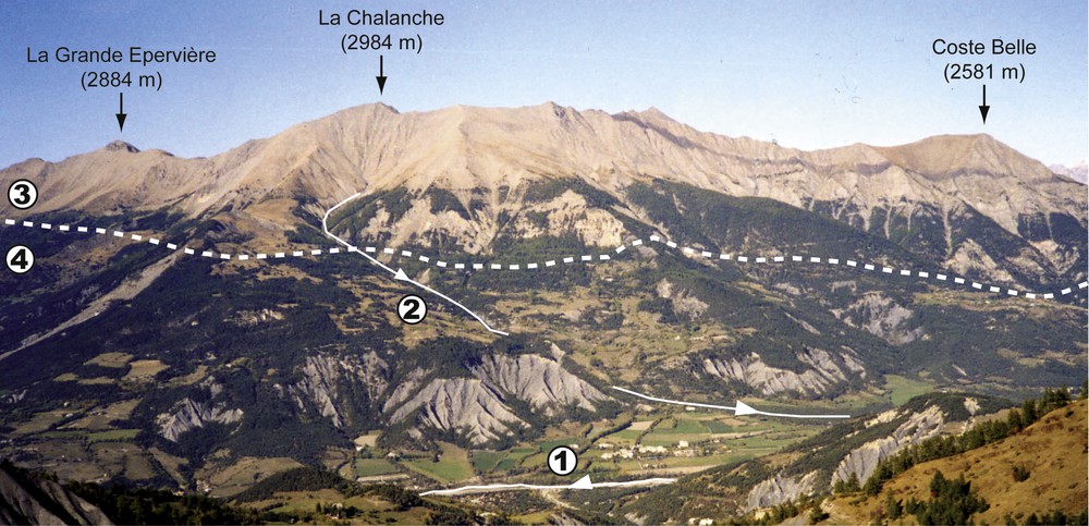
The south-facing slope of the Barcelonnette Basin from the southwest. (1: Ubaye River; 2: Faucon torrent; 3: Nappes of faulted calcareous sandstones; 4: Gentle slopes in the black marls).
Vue depuis le sud-ouest du versant adret du Bassin de Barcelonnette (1 : L’Ubaye ; 2 : le torrent de Faucon ; 3 : nappes de flyschs tectonisées (calcaires grèseux) ; 4 : versants taillés dans les marnes noires.
These predisposing factors explain the occurrence of several mass movements (Flageollet et al., 1999), active torrential streams and debris tracks (Remaître, 2006). About 50 debris flows have occurred since 1930 (Fig. 3B). The climate-debris flows relationships have been analysed for the recent times (period 1928–2010) at the annual, daily and hourly time scales (Remaître et al., 2010). The long-term rainfall pattern indicates cyclic variations of 10–15 years of the annual rainfall amount (Fig. 3A). These variations comprised periods of 5 to 7 years of annual rainfall amounts in excess to the mean annual rainfall. For example, some wet years or periods of excess rainfall correspond to years in which many debris flows occurred, for example, 1963, 1970 and 1996. However, some relatively dry periods (e.g. 1987, 1996) are also characterized by the occurrence of debris flows, testifying to the complexity of the climate–debris flows relationships for this time span.
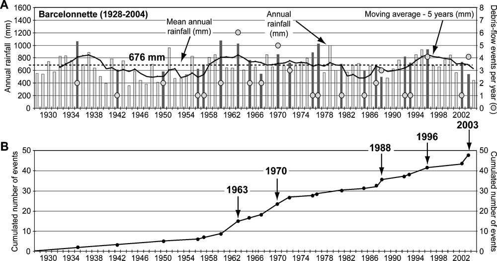
Relationship between annual rainfall and the number of debris-flow events per year. A. Annual rainfall in the Barcelonnette Basin (1928–2004). B. References of debris-flow activity.
Relations entre la pluviométrie annuelle et le nombre d’épisodes des laves torrentielles par an. A. Pluviométrie annuelle au poste de Barcelonnette (1928–2004). B. Historique des épisodes de laves torrentielles.
At the daily scale, on the basis of about 20 events for which an exact date of occurrence was available, two types of climate situation have been identified (Malet et al., 2007; Remaître, 2006): type A situation corresponds to heavy daily rainfall, generally associated to a violent summer thunderstorm, following a 30-days dry period; type B situation is characterized by heavy cumulative rainfall distributed over a 30-days very humid period.
2.2 The Faucon catchment
The Faucon torrent (44°25′N, 6°40′E) is located in a steep forested catchment with an area of 10.5 km2, which rises up to 2984 m a.s.l. (Fig. 4). The upper slopes of the massif consist of two superimposed nappes of sandstones and calcareous sandstones. The lower slopes consist of Callovo-Oxfordian black marls, covered by various Quaternary deposits which exhibit a sandy-silt matrix, may include boulders up to 1–2 m in size and are between 3 and 15 m thick.
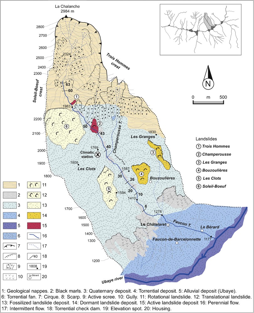
Morphological sketch of the Faucon catchment.
Carte géomorphologique simplifiée du bassin versant du torrent de Faucon.
The incised channel has an average slope of about 20°, ranging from 80° in the headwater catchment to 3° on the alluvial fan, and is approximately 5500 m in length (Fig. 5A). The channel morphology is characterized by two main types of cross-section, a V-shaped cross-profile with a steep channel (Fig. 5B), a flat-floored cross-profile between steep slopes (Fig. 5C).
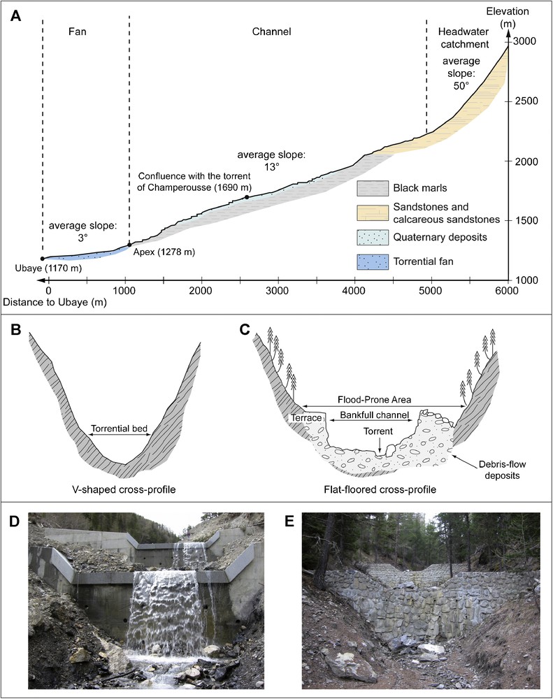
Morphological aspects of the Faucon channel. A. Longitudinal profile of the Faucon torrent. B. V-shaped cross-profile. C. Flat-floored cross-profile. D. View of a concrete check-dam. E. View of a dry-stone check dam.
Morphologie du chenal torrentiel du Faucon. A. Profil en long du torrent. B. Profil transversal en V. C. Section en travers en auge. D. Vue sur un seuil torrentiel bétonné. E. Vue sur un seuil torrentiel en pierres sèches.
The Faucon torrent has formed a 2 km2 debris fan, which spreads across the Ubaye valley floor. It has a slope gradient ranging from 2 to 9°. The fan consists mostly of cohesionless and high-permeable debris (debris-flows strata and/or torrential deposits).
The Faucon stream has a classical torrential flow hydrological regime associating: high peak discharges in spring (snow melting) and in autumn (high precipitations); and a high variability in summer according to the occurrence of storms. Since 1850, fourteen debris flows have occurred in the torrent. Two major events occurred in 1996 (Remaître et al., 2005a) and in 2003. About a hundred check dams have been built in the torrent since the 1890s to prevent flooding, but only a half of them are still efficient (Remaître and Malet, 2010; Remaître et al., 2002). Two main types of check dams can be observed (Fig. 5D, E): concrete check dams; dry-stone check dams. The torrent is divided in more or less one hundred reaches (a reach is a portion of the torrent situated between two check dams).
3 Kinematics of the 2003 debris-flow event
The hydro-climatic and the morphological characteristics of the August 5, 2003 debris-flow event are presented and discussed. Particular attention is paid to the estimation of the debris-flow volume along the flow track because it is fundamental for hazard assessment on the alluvial fan. The estimate of the volume is based on a field survey before and after the debris-flow event.
In order to present clearly the estimate of the volume of scoured material by the entrainment processes, the triggering and the deposition conditions are presented and discussed before the runout conditions. A two-step methodology is adopted:
- • a general appraisal between, on one hand, the volume of failed material in the triggering zones, and on the other hand, the volume of material in the deposition zones located in the channel and on the alluvial fan;
- • a detailed analysis of the debris-flow volume changes during the runout based on the volume estimate for each torrential reach. In order to simplify the volume calculations, morphology of the debris-flow (deposits and scoured areas) and check-dams location are mapped in a GIS database.
3.1 Analysis of the debris-flow triggering
3.1.1 Characterization of the rain event
The characteristics of the meteorological event with respect to the 2003 debris-flow triggering were investigated by rainfall analysis (Fig. 6). Rainfall has been analysed at the Barcelonnette (elevation 1155 m) and Jausiers (elevation 1510 m) rain-gauges, and at the Faucon (elevation 1815 m) “Les Clots” climatic station (Figs. 1 and 6A).
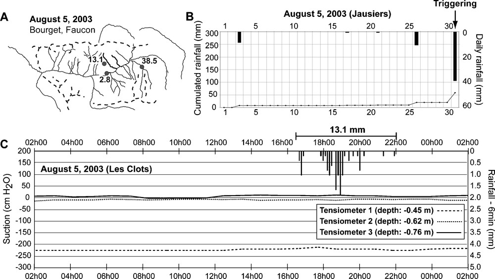
Rainfall characteristics associated to the triggering of the August 5, 2003 debris flow. A. Location map of the rain-gauges. B. Daily rainfall for the 30 days before the debris flow (Jausiers station). C. Rainfall and hydraulic pressure at the onset of the debris flow (Faucon “Les Clots” station).
Caractéristiques de l’épisode pluvieux à l’origine du déclenchement de lave torrentielle du 5 août 2003. A. Carte de localisation des postes pluviométriques. B. Pluviométrie pour les 30 jours précédant le déclenchement de la lave (poste de Jausiers). C. Pluviométrie horaire et pressions interstitielles relevées le jour du déclenchement de lave torrentielle (poste de Faucon « Les Clots »).
The 2003 spring and summer were particularly dry, the total amount of rainfall between 1st March and 1st August was less than 100 mm for the Barcelonnette and the Jausiers rain-gauges (60% less than the average for the period 1971–2000). The data for these stations indicate that no significant rainfall was recorded in the 30 days previous to the event (Fig. 6B). Therefore, antecedent rainfall cannot be considered as a relevant factor for the triggering of the 2003 event. The comparison between the daily rainfall of the three rain gauges shows that the rainstorm exhibited a very small spatial extent. Indeed, the Faucon station, which is localized near to the triggering area, has recorded a 13.1 mm rainfall while only 2.8 mm were recorded at the Barcelonnette rain gauge, and 38.5 mm at the Jausiers rain gauge (Fig. 6B). The relative low rainfall value recorded at the rain gauge and the lack of reaction of the tensiometers of the Faucon “Les Clots” station to the rainfall (Fig. 6C) have to be put in relation with the characteristics of the thunderstorm. Eyewitnesses confirm that the thunderstorm was accompanied by a severe hail fall. Hail precipitations cannot be easily recorded by rain gauges (Ceperuelo et al., 2006; Hogan, 2007; Phillips et al., 2007).
Analysis of the rainfall data indicates that the debris flow event:
- • was triggered by a thunderstorm of very small spatial extent;
- • that most of the rainfall occurred as hailstones;
- • that there were no significant antecedent rainfalls.
3.1.2 Morphology of the debris flow (triggering mechanisms and runout)
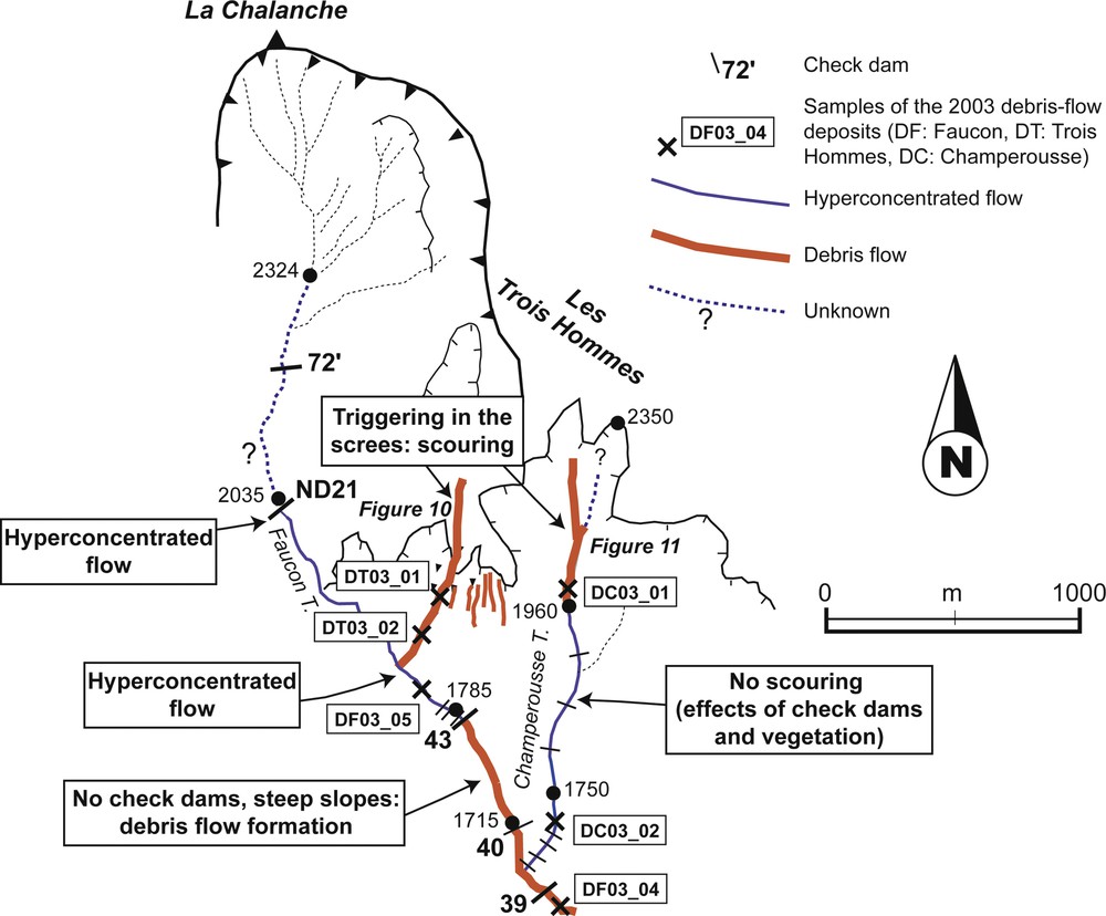
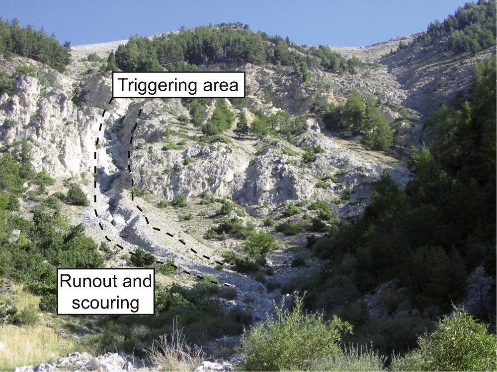
The debris flow was triggered on two slopes on the eastern part of the Faucon catchment (Fig. 7): the Trois Hommes slope (Fig. 8), and the upper part of the Champerousse torrent (Fig. 9).
Sketch of the sources areas of the August 5, 2003 debris flow in the Faucon torrent.
Schéma des zones sources de la lave torrentielle du 5 août 2003 sur le torrent de Faucon.
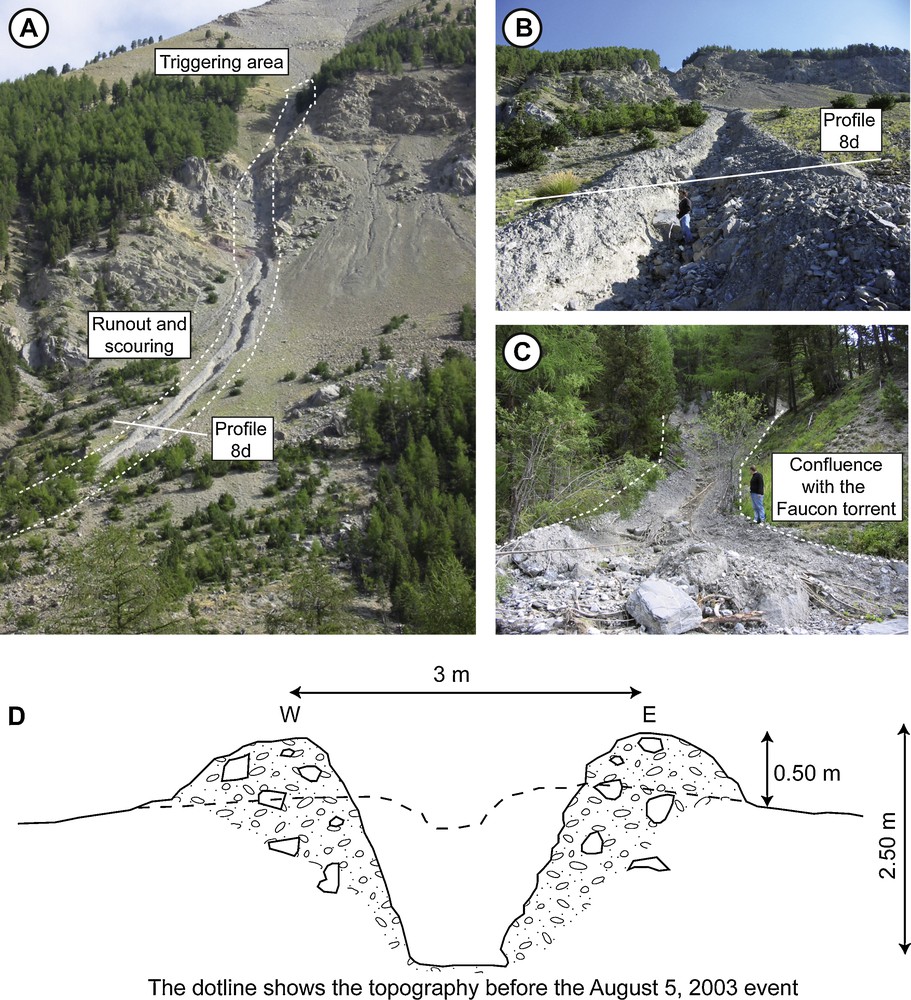
Morphology of the source area in the Trois Hommes slope. A. View of the Trois Hommes slope. B. View of the debris-flow track. C. View of the confluence between the debris-flow track and the Faucon torrent. D. Sketch cross-section of the Trois Hommes debris-flow track.
Morphologie de la zone source dans le tablier d’éboulis de la crête des Trois Hommes. A. Vue sur le versant des Trois Hommes. B. Vue sur le versant incisé par la lave torrentielle. C. Vue sur la confluence entre le chenal incisé par la lave torrentielle et le torrent de Faucon. D. Schéma d’une section transversale du chenal incisé dans le tablier d’éboulis du versant des Trois Hommes.
Morphology of the source area in the Champerousse torrent headscarp.
Morphologie de la zone source en tête de bassin du torrent de Champerousse.
For both cases, the morphology of the source area corresponds to a severe incision in scree slopes. In the Trois Hommes slope, the depth of the incision is about 2 m; the debris-flow path (Fig. 8A) widened from 2 m at the headscarp (Fig. 8B, D) to 5 m at the confluence with the Faucon torrent (Fig. 8C), 750 m further downslope. Thus, the volume of the solid material of the Trois Hommes debris-flow ranged approximately from 4000 to 5000 m3. No evidence of temporary damming was observed at the confluence, suggesting that the Trois Hommes debris-flow immediately flowed in the Faucon torrent main track. This excludes the hypothesis of a debris flow resulting from the breach of a temporary natural dam. The debris-flow material was sampled along the Trois Hommes flow path (sampling number DT03_01 and DT03_02; Fig. 7).
In the Champerousse torrent, the depth of the incision ranges from 2 m in the upper part to 1 m in the lower part; the width of the debris path is about 3 m. The volume of the solid material in the source area range from 6000 to 7500 m3. All the material did not reach the Faucon torrent; in fact, only 3000 m3 of material has been trapped by the check-dams (Fig. 7). Below the first check dams, some morphological evidences (no blocks and flat-shaped morphology of the deposits) indicate that the Champerousse debris-flow transformed into a hyperconcentrated flow. Two material samples have been collected (sampling number DC03_01 and DC03_02: Fig. 7). Thus, according to the observations along the Trois Hommes slope and the Champerousse torrent, the source volume ranges from 7500 to 9500 m3. Unfortunately, the solid concentration (ϕ) of the debris flow could not be measured in the source area; nevertheless, according to some previous works in the Barcelonnette Basin (Malet et al., 2005; Remaître et al., 2005b) and in the Bachelard valley (Blijenberg, 1995, 2007), values for the solid concentration of 0.50 to 0.60 can be considered. According to these values, the total volume (water + sediments) of the debris flow for the triggering area can be estimated to 14,000 m3 (ϕ = 0.60) to 17,000 m3 (ϕ = 0.50).
3.2 Analysis of the debris-flow runout characteristics
On the upper part of the torrential fan, most of the deposited debris has filled the channel; the debris flow has started to spread below the VC3 Bridge (Fig. 10A, B). Mudlines and splatters of fine-grained liquid sediments along both sides of the path revealed a nearly constant cross-sectional area (20 to 30 m2). Field measurements and evidence from the inhabitants indicate that the debris flow occurred in five or six surges, for a time interval ranging between 2 and 5 min. These debris-flow surges filled progressively the channel; the last surge overflowed and caused the occlusion of the VC3 Bridge. Eyewitnesses indicate that the debris-flow height of the last surge reached 5 to 6 m. Most of the debris spread over the left bank, causing some substantial damages on five houses (Fig. 10C).
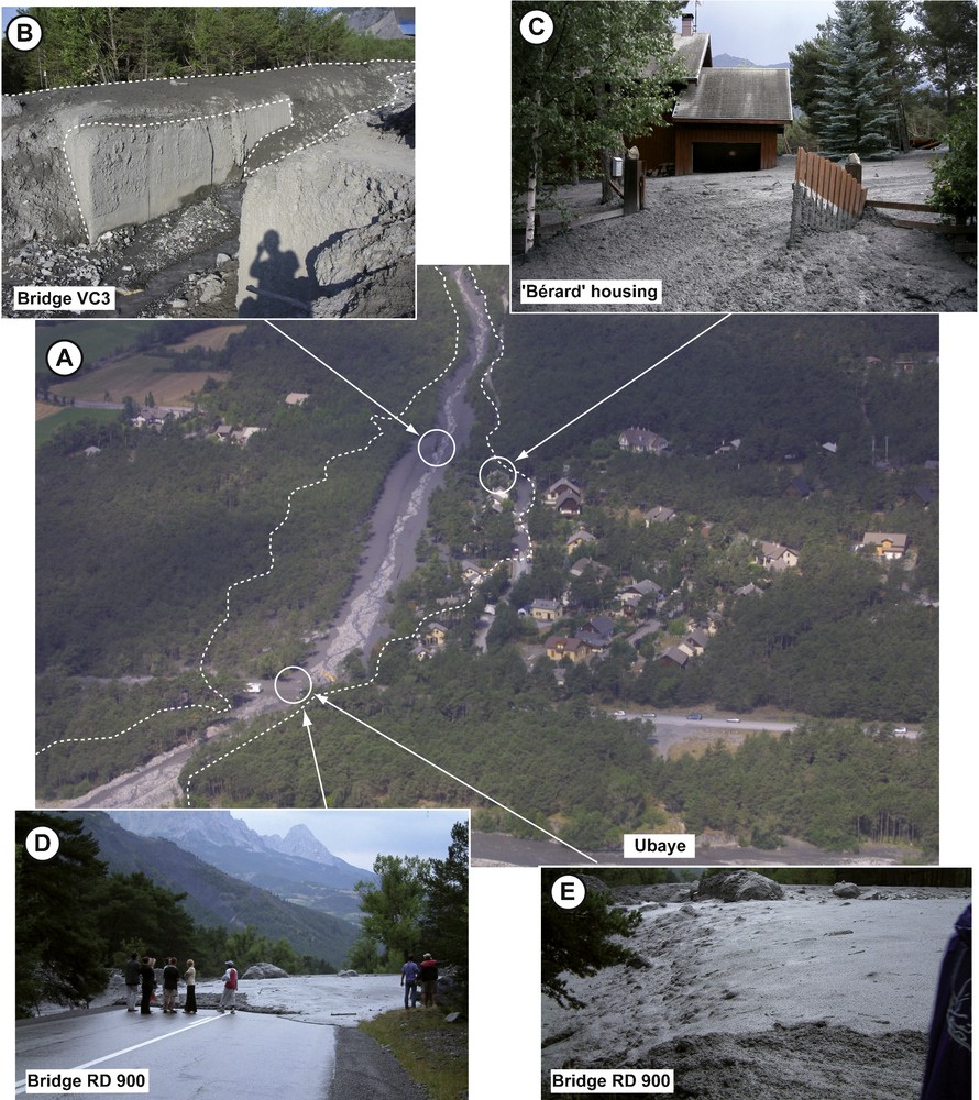
Spreading of the 2003 debris flow on the Faucon torrential fan. A. Aerial view of the Faucon fan (courtesy from Michel Peyron, ONF/RTM). B. VC3 Bridge completely destroyed. C. Example of overflowed house. D. End of the debris-flow event at the RD 900 Bridge. E. View of the “fresh” debris-flow deposit at the RD 900 Bridge.
Étalement de lave torrentielle de 2003 sur le cône de déjection du Faucon. A. Vue aérienne du cône de déjection (photographie de Michel Peyron, ONF/RTM). B. Le pont « VC3 » complètement détruit. C. Une maison envasée par les dépôts de lave torrentielle. D. Dernière bouffée de lave au niveau du pont de la RD900. E. Vue sur des dépôts « frais » de la lave torrentielle au niveau du pont de la RD900.
Some inhabitants were in their houses when the overflowing occurred but remained uninjured. The thickness of the debris deposits ranged from 1.0 to 2.0 m. Moreover, the debris flow also overflowed the main road of the valley (Fig. 10D, E); the traffic was stopped during several hours and remained difficult during three weeks while authorities cleaned the channel.
Velocities were back-calculated on two cross sections (Fig. 11) along the channel using the vortex and the runup equations (Hungr et al., 1984; Iverson et al., 1994; Jakob et al., 1997; Johnson and Rodine, 1984) and multiplied by the cross-sectional area to obtain peak discharge. Velocities ranged from 6.4 to 8.9 m.s−1; velocities back-calculated with the runup equation are a little bit higher than those obtained with the vortex equation. Peak discharges ranged from 150 to 200 m3.s−1 (Table 1).
Morphological map of the scouring and deposition area of the 2003 debris flow in the Faucon torrent.
Carte morphologique de lave torrentielle de 2003 du Faucon, carte des zones incisées/érodées et des zones de dépôt.
Vitesses et débits de pointe de lave torrentielle de 2003.
| Cross-sectional area (m2) |
Channel longitudinal slope (°) |
Radius of curvature (m) |
Banking angle of the flow (°) |
Height of runup (m) |
Velocity (m.s−1) |
Peak discharge (m3.s−1) |
|||
| Vortex eq. | Runup | Vortex eq. | Runup | ||||||
| A | 24.6 | 10 | 22.6 | 5 | 2.6 | 6.4 | 7.1 | 157.1 | 175.7 |
| B | 22.1 | 16 | 24.7 | 12 | 3.9 | 7.8 | 8.9 | 173.3 | 195.8 |
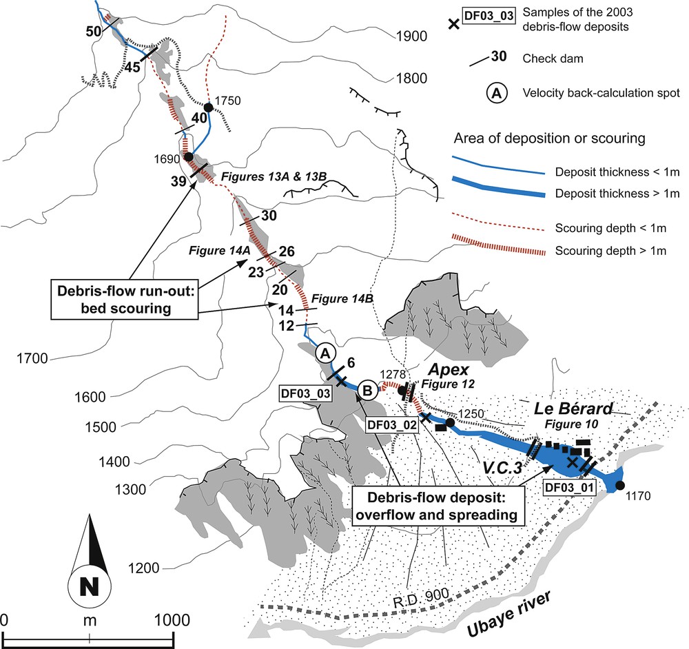
The event dynamics (e.g. high momentum due to the triggering mechanism, large volume of flowing material) and the boundary conditions (e.g. slope gradient, confined flow) may have led to a high flow velocity. A comparison with the 1996 debris flow (Remaître et al., 2005a) is presented in Section 5. The volume of debris flow deposited downstream of the source areas has been estimated by comparison of the morphology of the channel in July 2002 and the morphology of the channel a few days after the 2003 event (Fig. 12).
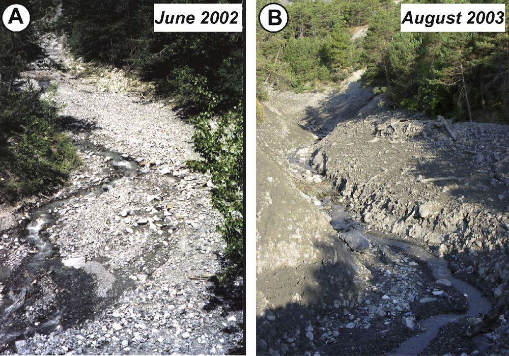
Comparisons of a torrential reach located on the apex of the Faucon. A. View pre-event in June 2002. B. View post-event in August 2003.
Comparaison entre deux photographies d’un bief torrentiel à l’apex du torrent de Faucon. A. Vue pré-évènement en juin 2002. B. Vue post-évènement en août 2003.
The area and the depth of the deposits were measured both in the channel and on the fan. Total volume of debris-flow deposits was estimated to be 45,000 m3 on the fan, and 15,000 m3 in the channel. Channel scouring is responsible for the great difference between the 7500–9500 m3 of the two sources areas and the 60,000 m3 of the debris flow in the runout and depositions zones. The total length of the debris-flow track is about 3500 m, with a slope gradient of about 20°. Several successive areas of erosion were observed. They have mainly developed in the 1996 debris-flow deposits (Fig. 13; Remaître et al., 2002, 2005a). Considering both the failed and the deposited volumes, and the length of the debris-flow track, the channel scour rate per metre can be calculated. The scour rate amounts to 15 m3.min−1. This value is in agreement with estimates by other authors in various lithological environments (Hungr et al., 1984; Jakob et al., 2000; Jibson, 1989). Observations of the channel after the event indicate that the scour depth ranges between 0.5 and 4 m (Figs. 13 and 14). The deposits on the fan were sampled in order to define the total solid fraction (ϕ), which ranged from 0.58 to 0.66. According to these values, the estimate of the total volume (water + solid material) of the debris flow ranges from 83,000 to 95,000 m3.
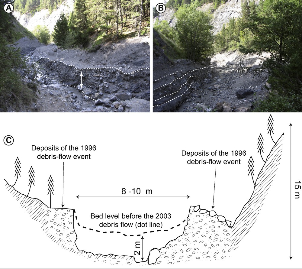
Morphology of the scoured reaches after the 2003 debris flow in the Faucon torrent. A. View of the Faucon track. B. View of the Faucon track. C. Typical cross-section of a scoured reach.
Morphologie de sections érodées par la lave de 2003 sur le torrent de Faucon. A. Vue sur le chenal du torrent de Faucon. B. Vue sur le chenal du torrent de Faucon. C. Section transversale caractéristique d’un bief érodé.
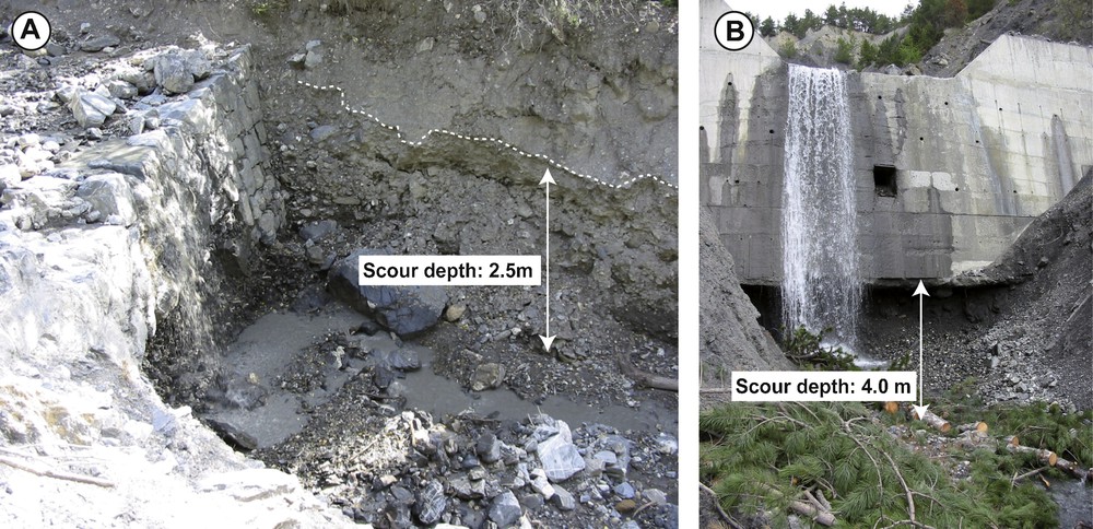
Morphology of the scoured reaches located at the toe of two check dams after the 2003 debris flow in the Faucon torrent. A. Example of check dam No 18. B. Example of check dam No 15.
Morphologie de sections érodées, au pied de deux seuils torrentiels, sur le torrent de Faucon après l’épisode de lave de 2003. A. Vue sur le seuil No 18. B. Vue sur le seuil No 15.
The most intense scour depth was observed at the toe of some check dams (Fig. 14), resulting from a regressive channel erosion. Depending on the channel slope and shape, small lobate deposits (thickness ranging from 0.50 to 1.5 m) related to possible debris-flow pulses could be observed. Lateral and channel bed deposition formed discontinuous narrow levees rising 1–3 m above the surrounding slopes on both sides of the channel (Fig. 13C). The material deposited in the channel consisted mostly of clast-rich, slightly bouldery, muddy gravel, with the clast-rich and coarser fractions of the deposits fringing the lobe margins and the top of the levees, where fine boulders and cobbles are concentrated. A strong reverse grading was observed. Three samples were collected in the channel (sampling number DF03_05, DF03_04 and DF03_03) and two on the debris fan (sampling number DF03_02 and DF03_01). The calculation of deposited and eroded volume is detailed in Remaître (2006).
4 Physical characteristics of the source material and of the deposits
4.1 Methodology
The sedimentological and rheological properties of the debris-flow deposits (grain-size distribution, petrography, yield strength, viscosity) were investigated:
- • to analyze the evolution of the debris-flow characteristics during the runout;
- • to identify the main surficial formations involved in the generation of this event.
Nine samples of interstitial matrix were collected at widely spaced locations along the main axis of the debris-flow event (Figs. 7 and 11) according to the methodology proposed by Maquaire et al. (2003). Debris-flow deposits were sampled at depth of 20 cm and 50 cm; the average weight of the samples was about 50 to 150 kg. All samples were oven dried and sieved from less than 20 mm to 0.050 mm; the fraction greater than 20 mm has been measured and characterized (petrography) in the field. The choice of this fraction (< 20 mm) for the grain-size distribution characteristics of the material was dictated by practical considerations and has been used by many authors (Berti et al., 1999; Bonnet-Staub, 1999) as it represents almost 60 to 90% of the weight of the total grain-size distribution. The proportion of fines (< 0.050 mm) was analysed by laser diffractometry. Some additional samples were collected using a cylinder cone to define the bulk density (dry and wet) of the sediment.
Previous works were conducted on the rheological properties of the flow-like landslides and the source material (Malet et al., 2003; Remaître et al., 2005b). The rheological analyses were performed using several methods (Fig. 15A): rheometry (Fig. 15B), slump tests (Fig. 15C), flume tests (Fig. 15D) and field estimates (Fig. 15E). This methodology was applied on two samples: DF03_01 and DF03_02. According to the grain-size distribution and the location (in the spreading area) of these deposits, the 2003 debris flow can be considered as a viscoplastic fluid in steady and uniform conditions.
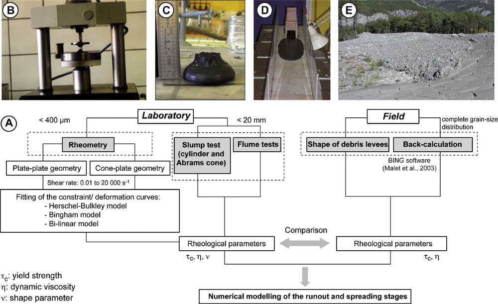
Methodology for the rheological characterisation of the material. A. Sketch of the experimental framework. B. Rheometry experiments using plate-plate geometry. C. Slump test. D. Flume test. E. Example of deposit of the 2003 debris-flow event (DF03_01).
Méthodologie de l’analyse rhéologique des matériaux. A. Schéma du protocole expérimental. B. Tests rhéométriques sur un rhéomètre plan-plan. C. Test d’affaissement au cône. D. Test d’écoulement en plan incliné. E. Vue sur un dépôt (DF03_01) de l’épisode de lave de 2003.
The detailed physical characteristics (including the rheological properties) of the source surficial formations (black marls, weathered limestones) can be found in Maquaire et al. (2003), Malet et al. (2004, 2005) and Remaître et al. (2005b). These works show, for instance, that the debris flows incorporating black marls can display changes of their physical state from rigid to fluid by adding only a small amount of water.
4.2 Results of the physical characterization
4.2.1 Sedimentology
The grain-size distribution obtained on the fraction passing 20 mm sieve shows a remarkable difference between the debris-flow deposit samples (Fig. 16A). The D50 for the samples varies from 0.15 mm to 5 mm, thus the textural classes ranged from loamy sand to sandy clay.
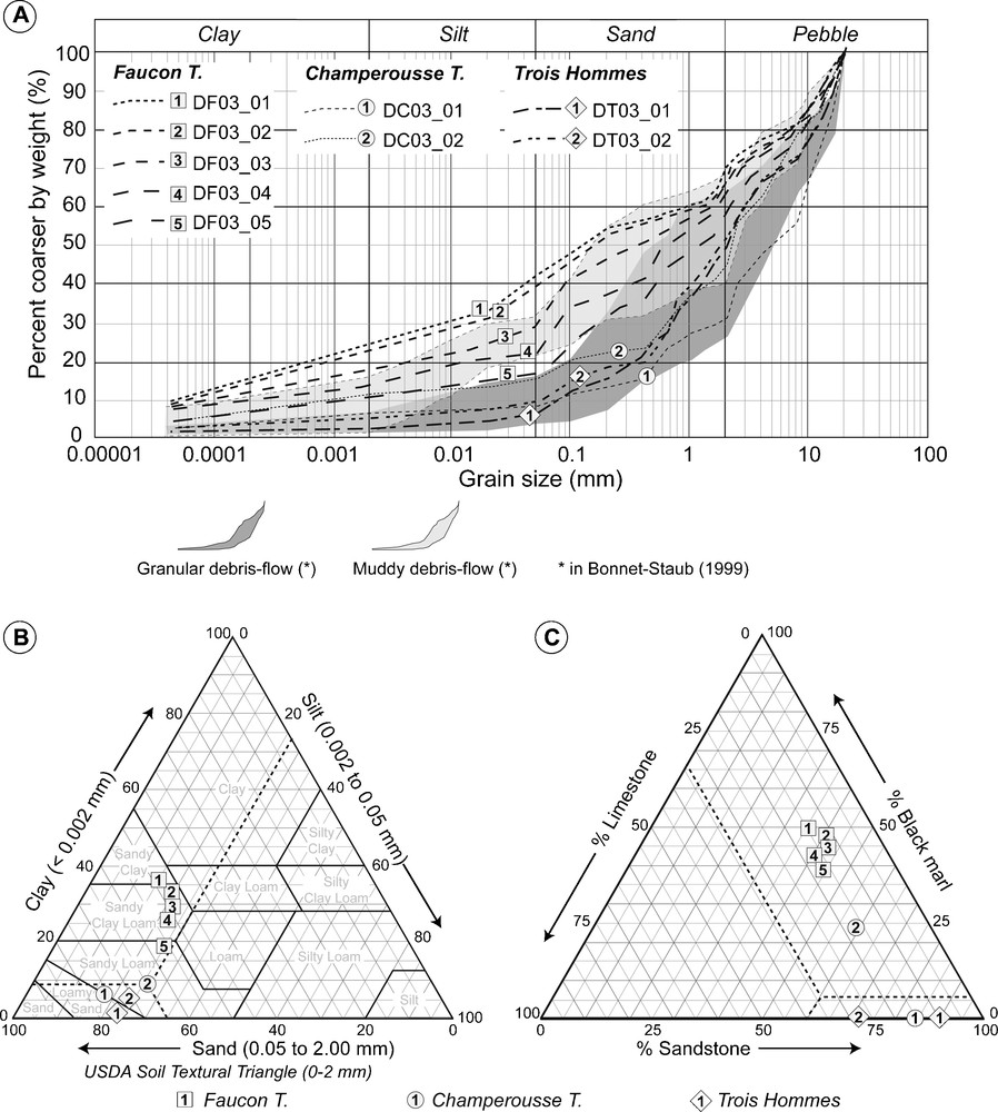
Grain-size distribution and petrography of the 2003 debris-flow deposits. A. Grain-size curves. B. USDA textural classification. C. Petrography of the debris-flow deposits.
Granulométrie et pétrographie des dépôts de lave torrentielle de 2003. A. Courbes granulométriques. B. Triangle de classification texturale USDA. C. Pétrographie des dépôts de laves torrentielles.
The Trois Hommes (DT03) and the Champerousse (DC03) deposits, sampled in the source areas, correspond to granular debris-flows flow materials (D50 varies from 2 to 5 mm) according to the classification of Bonnet-Staub (1999). The proportion of fine elements (finer than 0.050 mm) did not exceed 10%. According to the USDA soil textural triangular classification (Fig. 16B), these deposits are loamy sand or sandy loam. In both cases, the clay and the silt fraction increase with the distance to the source area. The cobbles and the pebbles of the coarse fraction (> 20 mm) are sandstones or limestones (Fig. 16C).
The Faucon deposits (DF03) correspond to muddy debris-flow deposits (D50 varies from 0.15 to 1 mm); the clay and silt content ranges from 16 to 33% corresponding to a sandy clay loam or sandy clay. The proportion of fine elements increases with the distance from the source areas. The petrography shows that the bulk of these muddy debris-flow deposits is derived essentially from the weathered black marls (40 to 50%). In the same way, the increase of black marls content logically induces an increase of the proportion of fine elements (16% for DF03_05 located near the source area at the head of the torrent, 33% for DF03_01 located on the fan). This characteristic has also been observed for the 1996 debris-flow event (Remaître et al., 2005a).
4.2.2 Rheology
The rheological behaviour was analyzed for different solid contents (from 37 to 55 per cent, by volume) and for different grain-size distribution (Fig. 15A). Given that the debris-flow fluids were slightly thixotropic (Malet et al., 2002) and the shear rate used was sufficiently low, the yield strength obtained by fitting models is a close estimate of the real yield strength (Coussot and Piau, 1994). The results for the four methods are synthesized in Fig. 17. The material behaves as a viscoplastic fluid, with a shear rate dependent behaviour, as obtained by other authors for clay-rich mixtures at similar stress conditions (e.g. Coussot et al., 1996; Major and Pierson, 1992; O’Brien and Julien, 1988; Sosio et al., 2007). The DF03 deposit exhibits viscoplastic behaviour for all shear rates, and can be well explained by a Herschel-Bulkley model. Rheological parameters (τc, κ) decreased with the total solid concentration by volume. The yield strength ranged from 1 to 270 Pa (Fig. 17A) and viscosity from 9 to 71 Pa.s (Fig. 17B). These values are slightly higher than those gathered from the deposits of the 1996 debris-flow; this as to be put in relation with the grain-size distribution of both debris-flow events deposits.
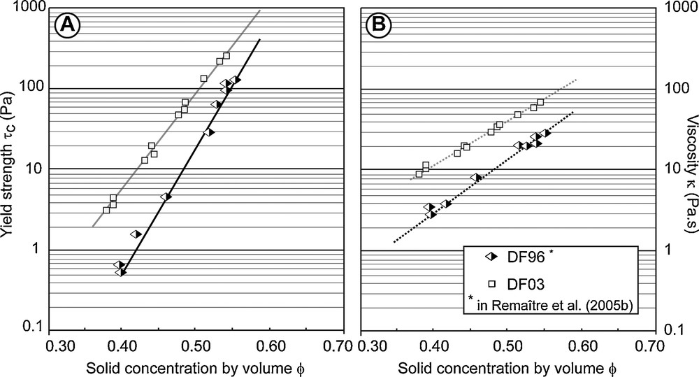
Empirical relationships relating yield strength (A) and viscosity (B) on varying the solid concentration by volume for two debris-flow events deposits.
Relations empiriques entre le seuil de contrainte (A) et la viscosité (B) selon la concentration volumique solide pour deux dépôts de laves torrentielles.
5 Synthesis of the 2003 event reconstruction
The 2003 debris-flow event was initiated as a granular flow and transformed into a muddy debris flow by incorporating marly sediments along the torrential paths. Such process was also observed during the 1996 debris-flow event (Remaître et al., 2005a, b). The grain-size change has to be correlated with the fact that both the source of sediment and its lithologic composition control the type of debris-flow. Moreover, in geologically heterogeneous catchment, the lithological heterogeneity of the clastic fraction produced complex debris-flow with a changing behaviour during runout. This is particularly true for soft rocks, which are easily scoured by a debris flow. In order to analyse more precisely relationships between the 2003 debris-flow kinematics and the morphological factors of the torrential reaches, a detailed appraisal of the sediment budget was performed. In this way, the evolution of the grain-size distribution and the petrography of the debris-flow deposits was compared with the sediment budget and the check-dam conditions before the 2003 event (Fig. 18).
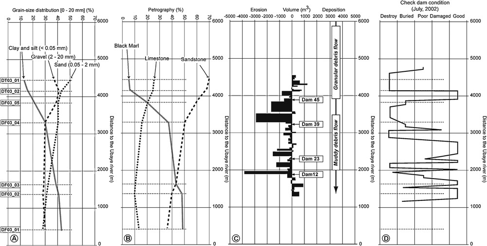
Reconstruction of the 2003 debris-flow event at the Faucon torrent. A. Evolution of grain-size distribution of the deposits. B. Evolution of petrography. C. Sediment budget of the 2003 debris flow. D. State of check-dams before the event.
Reconstruction de l’évènement de lave torrentielle de 2003 sur le torrent de Faucon. A. Évolution de la granulométrie des dépôts. B. Évolution de la pétrographie. C. Budget sédimentaire de lave torrentielle de 2003. D. État de vétusté des seuils torrentiels avant l’évènement.
Results show a correlation between the volume of scoured sediments and the state of the check-dams before the debris-flow event. There are two main torrent segments where the bulking was particularly intense: the first, located between check-dam 45 and 39, and the second, located between check-dam 23 and 12, are logically characterized by a general bad states (buried or destroyed). These reaches do not exhibit a steep longitudinal profile (about 7–9°). We could expect that the steeper reaches would be characterized by an intense scouring during the event, or this was not always true in the field. In fact, the reaches characterized by an intense scouring have been fully or partially filled by the 1996 debris-flow deposits (Remaître et al., 2005a) producing a large source of ‘available’ sediments for the 2003 debris-flow. Relationships between the 1996 and the 2003 events seem to be very close. The total volumes (water + sediment) of the two events are quite the same, about 100,000 m3 in 1996 (Remaître et al., 2002) while the volume of the 2003 event has been estimated around 90,000 m3. The spreading and the overflowing on the fan were much larger in 2003. This must be put in relation with the occurrence of a stream flow in June 2002. This stream flow filled partially or completely the lower reaches, located on the torrential fan, with fine-grained sediments (Fig. 12). This amount of sediments had a double effect: an increase of the bed profile level and a decrease of the flow sections.
6 Conclusion
The 2003 debris flow at Faucon is one of the last of several debris-flow events, which have occurred in the Barcelonnette basin since the middle of the 19th century. This event has been triggered by a violent thunderstorm. Morphological observations indicate that the debris flow has been triggered by a strong incision in scree slopes developing in a rocky substratum (sandstones and limestones). The volume of the debris flow progressively increased through the scouring of some reaches of the torrential channel. Grain-size and petrography analyses show that the 2003 debris-flow event started as a granular flow and then transformed into a muddy debris flow by incorporating clay-rich marly sediments along the torrential paths through scouring processes. Moreover, the scoured reaches were characterized by the bad state of the check-dams and by the presence of available deposits of previous events. These deposits have been scoured and incorporated within the flow, increasing the total volume and changing the type and the behaviour of the debris flow.
Acknowledgements
This work was supported by grants from the French Ministry of Research under the ACI-CatNat contract MOTE (MOdélisation, Transformation, Écoulement des coulées boueuses dans les marnes) and from the CNRS under the INSU-PNRN contract 2001–PR60 ECLAT (Écoulement, Contribution de LAves Torrentielles dans les bassins versants marneux). This research was also supported by the European Union through the research programme “Mountain Risks”. The authors wish to thank all the students, who help us in the field and Christophe Ancey for fruitful discussions on debris-flow rheology. The authors gratefully thank Pr Jean-Luc Schneider and an anonymous referee for their useful comments.