

1 Introduction
The geologic and economic importance of the silici-clastic deposits as oil and water reservoirs has incited several geologists to carry out many stratigraphic, sedimentologic, palaeontologic and structural studies in northeastern Tunisia (Abbès, 1983; Bédir, 1995; Bédir et al., 1996; Ben Ismaïl-Lattrache, 1981; Ben Salem, 1992; Biely et al., 1972; Blondel, 1990; Burollet, 1956; Colleuil, 1976; El Euch-El Koundi et al., 2009; Hooyberghs, 1995; Hooyberghs and Ben Salem, 1999; Jeddi, 2001; Khomsi, 2005; Mahjoub et al., 1989; Mannaï-Tayech, 2006, 2009; Moissette et al., 2010; Patriat et al., 2003; Robinson, 1971; Salaj and Stranik 1970; Tayech, 1984; Zouaghi et al., 2011).
In spite of many studies, the sequence stratigraphic analysis of surface and subsurface Miocene series and their correlation with various eustatic charts (Haq et al., 1987; Hardenbol et al., 1998) still remain defective. Especially, no work has taken into account regional and local events (eustasy, tectonics, and climate) in order to clarify the role of each parameter in the control of sedimentation and the sequence organization in this environment (Bédir et al., 1996; Ben Salem, 1990; Colleuil, 1976; El Euch-El Koundi et al., 2009; Mannaï-Tayech, 2006; Méon and Tayech, 1986; Tayech, 1984).
The Cap Bon Peninsula and the Gulf of Hammamet (Fig. 1), belonging to northeastern Tunisia, are located in the Maghrebian Alpine foreland and in the North of the Pelagian block. During the Cenozoic, the position of this area in the southern Tethyan margin edge generates eustatic, tectonic and climatic interactions (Bédir et al., 1996; Ben Ismaïl-Lattrache, 1981; Boujamaoui, 2000; El Euch-El Koundi et al., 2009; Mannaï-Tayech, 2006; Méon and Tayech, 1986).
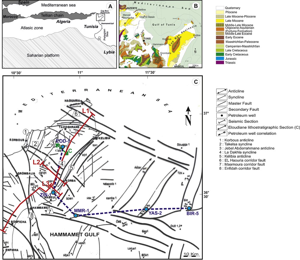
Geodynamical and geological setting of the study area (Cap Bon Peninsula and Hammamet Gulf): (A) structural setting of North Africa in the Mediterranean domain; (B) geologic map of the onshore outcrops of northeastern Tunisia; (C) structural map of the onshore and offshore areas showing the main surface and subsurface tectonic features (Bédir, 1995). This map shows the position of the outcrop section and the used petroleum wells and seismic lines.
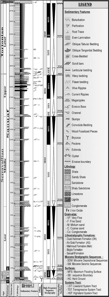
This work studies Middle and Upper Miocene deposits (Fig. 2), especially the Aïn Grab, Mahmoud, Béglia, Saouaf, Somaâ and Beni khiar Formations, and will be based on the combination of several analysis tools, namely sedimentology, facies analysis, sequence stratigraphy, seismic reflection stratigraphy, and wire line logging. In this work, the interpretation of seismic sections was based on seismic stratigraphy concepts (Vail et al., 1977; Van Wagoner et al., 1988).

Middle and Upper Miocene synthetic lithostratigraphic log of the northeastern Tunisia (Bédir et al., 1996) containing the onshore and offshore lithostratigraphic formations and their depositional environments. The main transgressive–regressive cycles have been defined by Ben Youssef et al. (2001).
The application of these tools allows us to identify third-order depositional and seismic sequences, with their associated systems tracts and parasequences, to specify the depositional environments from facies characteristics and to correlate the major stratigraphic surfaces (detected in outcrops, petroleum well and seismic section) with sea-levels changes (Haq et al., 1987; Hardenbol et al., 1998; Mitchum and Van Wagoner, 1991), tectonic control and climatic effects and to emphasize the relative role of tectonics and climate in the control of sedimentation in the Cap Bon and Gulf of Hammamet area.
2 Geological framework
The study area shows a succession of NE–SW pluri-kilometric anticlines and synclines extending from the onshore Cap Bon Peninsula to the onshore area of the Gulf of Hammamet (Fig. 1). The Jebel Abderrahmane anticline occupies the largest part of the Cap Bon Peninsula. It shows the oldest series exposed in the area (Fig. 1B) and related to the Middle Eocene Souar Formation (Burollet, 1956). This slightly dissymmetrical structure presents an inclination towards the east and an average NE–SW direction. It is affected by several radiant faults starting from the center of the anticline. These faults are directed in general N50 normal, N70, N130 and N160 sinistral and N90 dextral strike-slip (Ben Salem, 1992; Burollet, 1956) (Fig. 1C).
The subsurface tectonic map of the Tunisian eastern margin (Bédir, 1995; Bédir et al., 1996; Zouaghi et al., 2011) shows the existence of deformed platforms and grabens and synclines delimited by the master corridor faults trending N90–120 and N160–180 (Fig. 1C). The study area is spread out primarily over the northern Hammamet block, limited to the north and to the south by the N90–120 El Haouaria and the Maamoura–Hammamet tectonic corridors, and to the west by the N160–170 Enfidha corridor (Fig. 1C).
The Middle and Upper Miocene synthetic stratigraphic column of the onshore and offshore northeastern Tunisia includes several formations (Fig. 2), corresponding from base to top to: the Aïn Grab F., the Mahmoud (Begonia Shale) F., the Beglia/Lower Birsa F., the Saouaf (Intra Birsa carbonate, Upper Birsa and Upper Oum Douil) F., the Somaâ F. and the Beni khiar/Melquart F. Besides, Biely et al. (1972) have proposed the arrangement of these formations into two groups:
- • the Cap Bon group (Middle to Late Langhian) contains the Aïn Grab and Mahmoud Formations and corresponds to a marine sedimentary cycle;
- • the Oum Douil group (Early Serravallian to Early Tortonian) contains the Beglia and Saouaf Formations and corresponds to a fluvio-deltaic and marine cycle.
The Aïn Grab Formation has been defined by Burollet (1956) on the eastern side of the Abderrahmane outcrop. This bioclastic limestones containing Orbulina suturalis fauna that corresponds to the base of the N9 zone (Blow, 1969), which confers a Late Langhian age to these limestones (Bédir et al., 1996; Ben Ismaïl-Lattrache, 1981; Ben Salem, 1992; Besème and Blondel, 1989; Hooyberghs, 1995; Mannaï-Tayech, 2009). The base is always gullying with reworked elements derived from the the underlying Fortuna fluvial Formation, on which are deposited unconformably the limestones of the Aïn Grab Formation. This Formation is a regional good example of the global world-scale transgression defined on all stratigraphic charts (Ben Ismaïl-Lattrache, 1981; Hooyberghs, 1987, 1995) and a regional good seismic marker (Bédir et al., 1992; Bédir, 1995; Bédir et al., 1996; Haller, 1983; Touati, 1985)
The Ain Ghrab Formation is overlain by Mahmoud shaly Formation defined by Salaj and Stranik (1970) and then by Biely et al. (1972), on the eastern side of the Drafla outcrop, to the north of the Saouaf syncline. Their equivalents in the wells of the Gulf of Hammamet are named “Begonia shales”; they are composed of gray–greenish clays with planktonic fauna, which locally become sand and silt rich, especially at the edges of the high structures. The glauconitic clays of the Mahmoud Formation shows, in addition to Orbulina suturalis, the appearance of Orbulina universa, belonging to the top of the N9 zone (Blow, 1969). These characteristics allow us to attribute a Late Langhian–basal Serravallian age to this formation (Ben Ismaïl-Lattrache, 1981; Besème and Blondel, 1989; Hooyberghs, 1987, 1995). Its thickness increases in the depocenters, whereas it is reduced over the high zones. These thickness variations (0 to 80 m) are due to the syn- and post-Aïn Grab deformations.
The Beglia Formation, defined by Burollet (1956) on the eastern side of the Boudinar outcrop in central Tunisia, is mainly composed of sand and sandstone with cross beddings, fossilized wood, vertebrate fossils and shales intercalations (Robinson and Wiman, 1976) (Fig. 6). It presents, locally, channels with coarse filling and sometimes reworking of clays of the Mahmoud Formation, indicating a fluvio-deltaic environment. In 1984, Tayech attached this Formation to the Early Serravallian. The offshore lateral equivalents in the Gulf of Hammamet of this Formation are the clayey–sandy deposits of “lower Birsa” (Ben Ferjani et al., 1990).
Sedimentology and depositional sequence stratigraphy of the El Oudiane lithostratigraphic section at the Dakhla syncline (eastern flank of the Jebel Abderrahmane outcrop).
In eastern Tunisia, the Saouaf Formation, defined by Biely et al. (1972) at the Saouaf syncline, is a very thick series composed of clayey–sandy alternations. Clays contain locally levels of Ostrea, as well as lignitiferous levels (Abbès, 1983; Abbès and Polak, 1981; Ben Salem, 1992). Abbès (1983) distinguishes two units in this clayey-sandy series; the base unit, represented by sandstone and clay regular alternations and the higher unit, composed by prevalence of argillaceous levels at the base and sandy and lignites beds at the top. These units are capped by thick gray clays, known as “Argiles du toit” containing rare layers of sandstone. The Saouaf Formation studied in northeastern Tunisia was attributed to the Serravallian–Early Tortonian (Ben Salem, 1992; Bismuth, 1984; Colleuil, 1976; Jeddi, 1993; Mannaï-Tayech, 2006; Tayech, 1984).
The Somaa Formation, defined by Colleuil (1976) in the Nabeul area is exclusively continental azoic series represented by alternations of yellow or red sands, relatively coarse, with conglomeratic levels, corresponding to fluvio-torrential deposits (Ben Salem, 1992). By its stratigraphic position, between the Saouaf Formation, at the base, and the Melquart Formation, to the top, the Somaa Formation is attributed to the Tortonian, in the Cap Bon Peninsula (Ben Salem, 1990; Colleuil, 1976).
The Béni Khiar Formation (Colleuil, 1976) corresponds to the Messinian in the eastern Sahel and in northeastern Tunisia (Besème and Kamoun, 1988; Bismuth, 1984; Colleuil, 1976; Fournié, 1978); it is represented by oolitic limestones with some clay intercalations, marking a transgressive phase (Hooyberghs, 1993). It presents alternations of evaporates, limestones and argillaceous levels, containing planktonic microfauna (Globorotalia Conomiozea Kennet and Gl. Saheliana Catalano) of Early Messinian age (Besème and Kamoun, 1988; Hooyberghs and Ben Salem, 1999). The offshore lateral equivalent of the Béni Khiar Formation is the Melquart Formation, defined for the first time by Fournié (1978) at the level of the Melquart-1 drilling, in the Gulf of Gabes. Concerning the Late Miocene “Messinian Salinity Crisis”, few studies have focused on the central part of the Mediterranean Basin. They have emphasized the Messinian subaerial erosion, which is partly prolongated in its distal part (Bache et al., 2009; El Euch-El Koundi et al., 2009).
The various wells of the onshore and offshore areas that are drilled on the top of anticline structures start with the erosive-base unconformably overlain by bioclastic limestones of the Aïn Grab Formation. above, we distinguish glauconitic clays of the Mahmoud Formation, then the sandy Beglia (s.s.) Formation and, finally, the clayey-sandy alternations of the Saouaf Formation. For the El Oudiane-1 well (EOD-1), the sedimentary column starts with the Aïn Grab limestones and ends with the Saouaf Formation. To the southern and eastern areas, in Zinnia-1 and Birsa-5 wells, the Saouaf Formation is capped by the Somaa sands. The Maamoura-1 and Yasmine-2 wells drilled in offshore in the Gulf of Hammamet show an abnormal contact between the Saouaf Formation and the overlying Messinian limestones of the Melquart/Beni Khiar Formation. These limestones are missing in all the other wells used in this study.
3 Subsurface structuring
3.1 Onshore–offshore lithostratigraphy correlation
This correlation (Fig. 3) integrates the El Oudiane-1, Zinnia-1 onshore, Maamoura-1, Yasmine-2 and Birsa-5 offshore oil wells. It extends from the southeastern end of Cap Bon Peninsula to the eastern end of the northern Hammamet block and crosses a number of master corridor faults trending NW–SE, east–west, north–south and NE–SW.
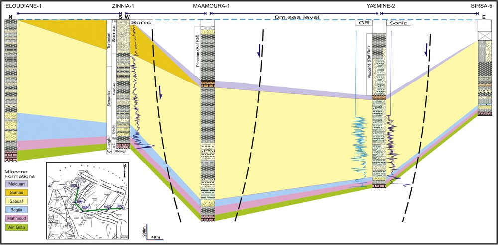
Middle and Upper Miocene lithostratigraphic correlation through petroleum wells showing differential variation in thickness, high and low structures.
In the onshore, the correlation shows, from north to south, a thinning of the Aïn Grab bioclastic limestones and a less pronounced thinning of the clayey Mahmoud Formation. The Beglia Formation sandstones become also thinner towards the same direction, with the appearance of some argillaceous levels. The Saouaf Formation of the northern part of Cap Bon (El Oudiane-1 well) shows almost the same lithostratigraphic succession as that observed in the Zinnia-1 well (clays, clay-sandstone alternations and lignites), with a thinning always from the north to the south. The Somaa sands are thick in the southern part of the Cap Bon, they pinch out from the south towards the north and completely disappear at the level of the El Oudiane well, which is is most likely caused by non-deposition or erosion towards the Jebel Abderrahmane anticline (Figs. 3 and 4).
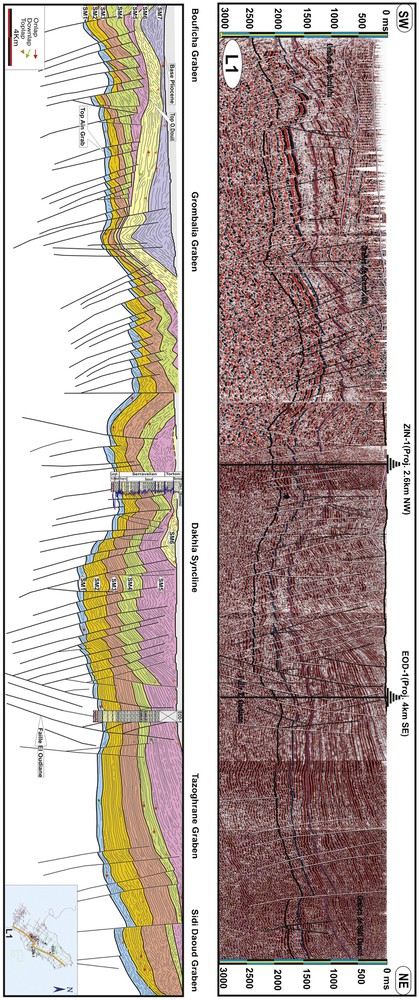
Interpreted seismic line L1 (Location shown in Fig. 1), illustrating the structuring of the Cap Bon Peninsula and the distribution of Middle and Upper Miocene seismic sequences and their evolution towards NW–SE trending faults.
In the offshore area, the correlation shows a weak thinning, from the west to the east, of the unconformable Aïn Grab limestones, the Mahmoud clays and the Beglia sandstones. Moreover, this correlation emphasizes a significant thickening of the Saouaf Formation at the level of the Maamoura-1 well and a pinching out of the Melquart deposits on both sides of the Maamoura-1 and Yasmine-2 wells.
The superposition of the correlation profile on the tectonic subsurface map (Bédir et al., 1996) shows the existence of an anticline structure on which the Yasmine-2 well was drilled. Other high structures can be also detected at the level of the Birsa oil field, which is marked by the absence of most of the Oligocene sedimentary sequence (Bédir, 1995; Bédir et al., 1996; El Manaa, 1996). After the compressional event of Early Miocene (Burdigalian), which folded the structures, Langhian post-Aïn Grab and syn-Mahmoud extension induced the collapse of these structures. This is also confirmed by the angular unconformity of the Messinian carbonated platform (Melquart limestones) on this relatively higher zone. The collapse and further folding of these structures can be explained by the reactivation of the N120 faults bordering the Yasmine structure and north–south to N120, bordering the Birsa ante-Langhian high structure.
During the Middle Langhian–Early Tortonian interval, which coincides with the deposition of the Aïn Grab, Mahmoud, Beglia and Saouaf, the northern part of the Cap Bon Peninsula, containing the Tazoghrane graben, was always a low subsiding zone. The Miocene sedimentary basins formed during the Langhian extensive/transtensive phase contained enormous quantities of dominantly silicoclastic deposits. Since the Serravallian, a small synchronous subsidence had been associated with the Beglia and Saouaf Formations. This subsidence reaches its paroxysm during the Late Serravallian–Early Tortonian, period of sedimentation of the upper part, essentially argillaceous, of the Saouaf Formation “clay of the roof”.
Since the Tortonian contractional Atlasic phase, the collapsed northern part of the Cap Bon Peninsula was marked by the accentuation of several folded structures largely known in the area (Bédir, 1995; Bédir et al., 1996; Ben Salem, 1992; Boujamaoui, 2000; Tayech, 1984; Zouaghi et al., 2011). The Abderrahmane anticline, part of the network of the Atlasic folds constitutes a high zone, which can explain the absence of the Somaa Formation in the El Oudiane-1 well located on its flank.
3.2 Tectonic control
Analysis of the seismic lines shows a regional outline on the subsurface tectonic framework in the Cap Bon Peninsula and the Gulf of Hammamet. The structuring is represented by high and low structures.
The seismic profile L1 (Fig. 4) shows, in its northeastern part, a remarkable thickening of the Miocene series from the southwest (El Oudiane well, EOD-1) to the north-east. This can be explained by the opening of the Tazoghrane graben at the Langhian, which induced an additional space for deposition. This graben (Fig. 4), which shows thick Miocene series, also proven in outcrops (Oued Eddefla section), is currently raised, testifying to a tectonic inversion that seems to have occurred during the Tortonian. This interval is marked by the NW–SE Atlasic compressional tectonic phase (Bédir, 1995; Bédir et al., 1996; Ben Salem, 1992; Boujamaoui, 2000; Melki et al., 2010, 2011; Zouaghi et al., 2011), which is at the origin of the NE–SW trending folds (e.g., Abderrahmane anticline and synclines of the Dakhla and Takhelsa). Tectonic inversions and intensive fracturing are clearly observed in outcrops and on seismic profiles.
The seismic line L2 (Fig. 5) shows the eastern part of the Abderrahmane anticline structure and that of the Dakhla syncline. These folded structures are affected by normal and reverse faults inducing the genesis of high and low tilted blocks at the edge of the folds. This structuring shows the faulting of the eastern margin of Tunisia containing the Cap Bon Peninsula and the Gulf of Hammamet; it is represented by tectonic blocks bordered by inherited master strike-slip fault corridors trending east–west, north–south, and NW–SE.
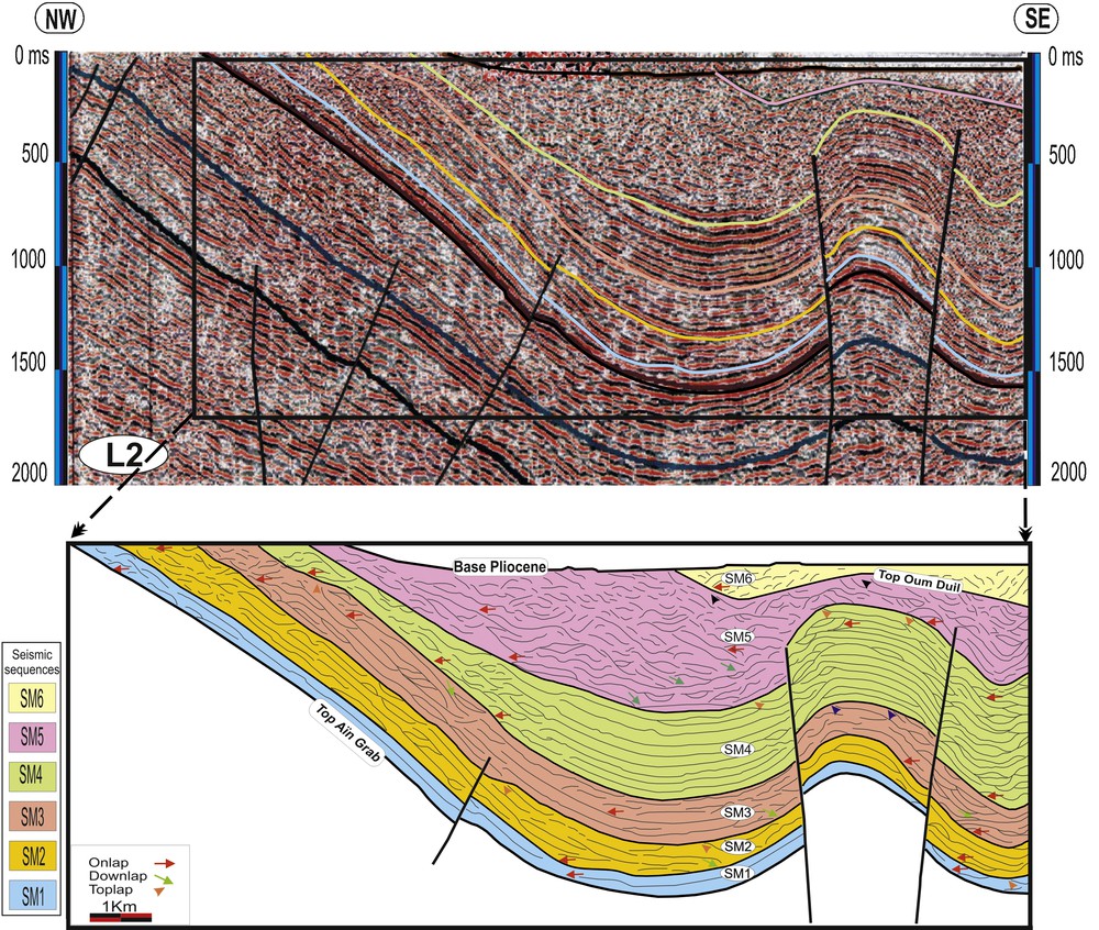
Seismic section L2 (Location shown in Fig. 1) and interpretation across the Dakhla syncline, showing the thickening of Middle and Upper Miocene seismic sequences in the depocenter and its thinning and pinching out towards the faulting borders.
The L3 profile (Fig. 7) illustrates the deep structuring of a transverse section of the Dakhla syncline, located at the southernmost end of the periclinal closing of the Abderrahmane outcrop. This folded structure shows normal as well as reverse faults.
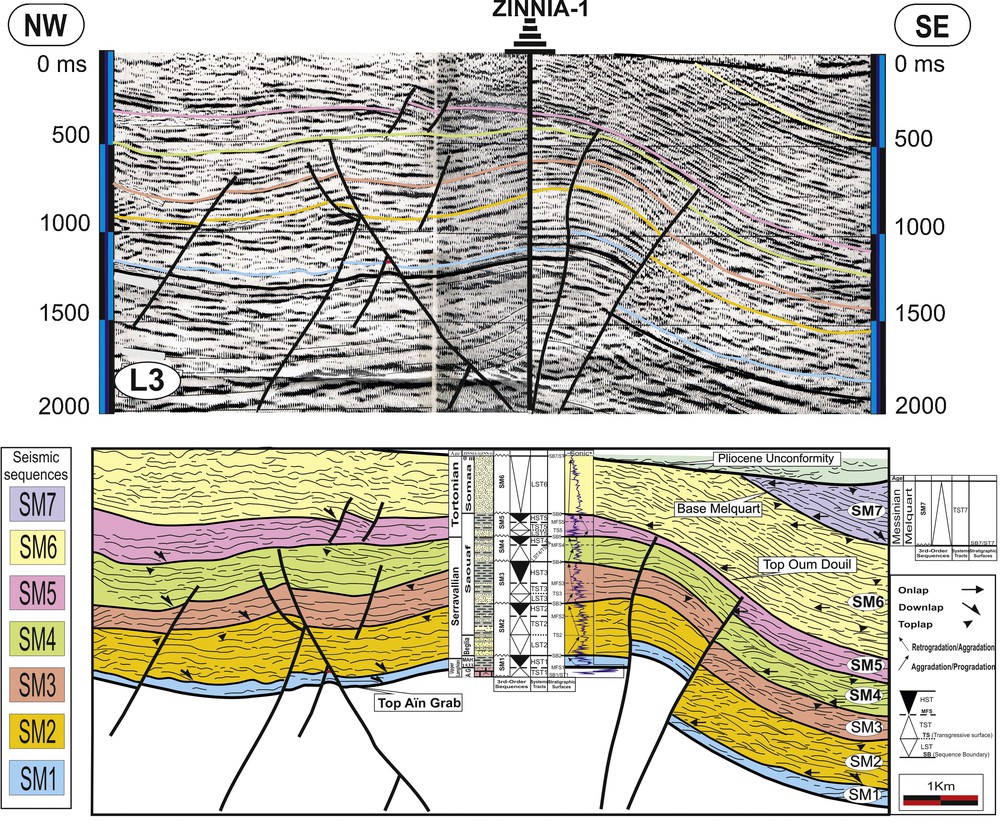
Structuring and seismic sequence stratigraphy of Middle and Upper Miocene deposits on the eastern part of Cap Bon Peninsula (Dakhla syncline).
The structuring of folded horsts and grabens, detected on the studied seismic lines, is known in the Cap Bon Peninsula outcrops. These folded structures are affected essentially by normal and strike-slip NE–SW- and east–west-trending faults. The central horst is bordered by the Sidi Daoud graben to the northeast and the Grombalia graben to the southwest (Fig. 1).
The El Haouaria, Maamoura-Hammamet, Enfidha and Kuriate master fault corridors are preferentially marked by dextral and sinistral transpressional movements, inducing the genesis right and left drag folds and synclines, with echelon position compared to the fault corridors, such as the Abderrahmane, Takelsa, and Dakhla, which left drag folds.
The majority of the normal faults that bordered horst and graben structures are sealed by “clays of the roof” of the Saouaf Formation of the Early Tortonian (Ben Salem, 1992). These dextral and sinistral transtensional movements began at the Oligocene and continued until the Tortonian, when the thick sedimentary series were taken again in transpressional movements generating echelon folds within the grabens. The time of maximum transpressional events corresponds to the Early Miocene Burdigalian–Serravallian, the Late Tortonian and the end of the Messinian.
Most normal faults reach the ante-Neogene substratum and are likely to have been reactivated during the later Tortonian Atlasic contractional tectonic event, generating a change in the tectonic mode and thus a stress field in a compressional and transpressional context. The Miocene and Pliocene intervals are marked once again by extensional/transtensional movements, which have caused reactivation of the inherited faults.
On the chronological scale, the Burdigalian transpressional, Langhian transtensional, Early Serravallian transpressional, Late Serravallian transtensional and Tortonian transpressional reactivation phases (Abbès, 1983; Bédir et al., 1996; Ben Salem, 1992; Boujamaoui, 2000; Khomsi, 2005; Mahjoub et al., 1989; Zouaghi et al., 2011), reactivating the inherited fault framework, are short and close one to the other, which can explain the coexistence of extensive and compressive structures.
4 Miocene sequence stratigraphy of the Cap Bon Peninsula
The sequence analysis of Miocene series is based on lithostratigraphic and sedimentologic sections (Fig. 6) carried out on Jebel Abderrahmane outcrops and seismic profiles (Fig. 7) accompanied by petroleum well data (Figs. 7 and 8).
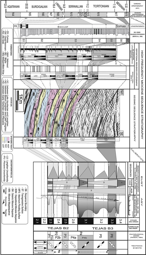
Correlation of Middle and Upper Miocene depositional sequences (El Oudiane lithostratigraphic section and Zinnia-1 petroleum well) and seismic sequences to the eustatic curves (Haq et al., 1987; Hardenbol et al., 1998) and significance of remarkable stratigraphic surfaces in relation to eustatic, tectonic and climatic events (assuming that SB corresponds to the maxima of the sea-level falls and MFS to the maxima of the sea-level rises).
On the lithostratigraphic section of Jebel Abderrahmane silici-clastic outcrops, we can distinguish regional sedimentary discontinuities and organized correlative superimposed units. The lithostratigraphic section of El Oudiane (Fig. 6), carried out on the Jebel Abderrahmane eastern flank, shows only five third-order depositional sequences (Miocene Depositional Sequence, SDM1-SDM5), with associated systems tracts. There is an unconformity with missing Late Tortonian and Messinian, as Pliocene deposits directly overlay the Lower Tortonian SM5 sequence. On the Zinnia-1 petroleum well (ZNN1), we can discern six depositional sequences (SDM1-SDM6) (Figs. 7 and 8).
The calibration of the Aïn Grab and Melquart horizons, also identified in the petroleum well data, enabled us to identify seven third-order seismic sequences (Miocene Sequence, SM1-SM7) in the Langhian–Messinian interval time. In the subsiding zones, such as grabens and synclines, these sequences appear thicker and complete (Fig. 7).
The differences in the depositional sequences between seismic outcrops and wells are due to the studied section in the center of basin and to anticline flanks marked by the absence or erosion of the Upper Miocene sequences from SDM6 to SDM7.
4.1 The SDM1/SM1
The first depositional sequence (SDM1) is composed by the bioclastic limestone Aïn Grab Formation, at the base overlain by clays of the Mahmoud Formation, with planktonic microfauna (Fig. 6). These limestones are marked by an erosional ravinement base, with polygenic micro-conglomerate, corresponding to a regional angular unconformity marked by the contact of the fluvio-deltaic continental series of the Fortuna Formation with the transgressive marine series of the Aïn Grab Formation. The latter is organized in deepening-upward retrograding parasequences marking the deepening of environment deposits and the inhibition of the sedimentary silici-clastic continental flow. These transgressive deposits are represented in our sector by a succession of 20 to 25 m of five bioclastic fossiliferous limestone beds with intercalated decimetric argillaceous/sandstone alternations, which constitute the Transgressive System Tract (TST1) of the SDM1.
The Maximum Flooding Surface (MFS1), corresponding to the condensed decimetric limestones section, presents a high concentration of shelly limestone deposits.
The HST1 is represented by the Mahmoud argillaceous Formation, with planktonic fauna, marking the filling of the basin during a relative sea-level rise.
On seismic profiles, the SM1 is limited, at the base, by the Aïn Grab marker horizon and, at the top, by the regional horizon of the base of the Béglia sandstone Formation. The Aïn Grab horizon exhibits a major angular unconformity with the underlying units (Figs. 5 and 7).
The seismic facies of this sequence is very characteristic, marked by dominant low-amplitude and medium to low continuity reflections, indicating a transparent facies related to argillaceous prevalence (Table 1). The internal reflections of this sequence show progradational clinoforms in sigmoid and shingled, marking a shallow-to-deep water environment with low to high energy.
Characterization of the reflections of the Middle and Upper Miocene seismic sequences (SM1-SM7) in the Cap Bon Peninsula.
| Seismic sequences | Seismic facies/configuration | Continuity | Frequency | Amplitude | Example |
| SM1 | Progradational clinoforms in shingled | Medium to discontinuous | Low | Low | |
| SM2 | Hummocky, shingled and lenticular | Medium/irregular | Medium | Variable | |
| SM3 | The same seismic facies compared to SM2 | ||||
| SM4 | Hummocky, shingled and lenticular | Medium | Low | High | |
| SM5 | Chaotic | Discontinuous | Low | Low to medium | |
| Divergent | Continuous | High | Medium to high | ||
| SM6 | Hummocky | Discontinuous | Low | Variable | |
| Shingled | Medium | Medium | Medium | ||
| SM7 | Parallel to sub-parallel | Continuous | High | High |
4.2 The SDM2/SM2
This sequence corresponds to the exclusively sandy Béglia Formation (s.s.) (Burollet, 1956) and is overlaid by the clays, with planktonic fauna, of the Saouaf Formation (Fig. 6). The ravinement contact, with polygenic conglomerate, is marked by the deposition of the Béglia shallow marine coastal deposits on the marine clays of the Mahmoud Formation; it could constitute a Sequence Boundary (SB2). The LST2 is represented by the regressive and lowstand fluvial channel sands of the Béglia Formation. These deposits show coarse deposits (pebbles of quartz and conglomerate), oblique tabular bedding, oblique tangential bedding, cross-bedded, scroll bars, megaripples and asymmetrical current ripples at the top of the sandy bars. These sandstones pass towards argillaceous levels overlain by intensively bioturbated surface at the top fine sandstone bars. Thus, these beach fine deposits were deposited during relative sea-level rise and coincide with the TST2. On the El Oudiane lithostratigraphic section (Fig. 6), the maximum flooding surface (MFS2) can coincide with the maximum argillaceous level at 370 m, which comes just before the following progradational sandy deposits.
The HST2 marks the beginning of the aggradation/progradation; therefore, the change of tendency transgression/regression is represented by a succession of coarsening-up and thickening-up prograding parasequences of shallowing-upward type, showing fine to middle grain size, planar laminations, lenticular and wavy bedding, bioturbation and oyster and pecten-rich sandstones in some levels. These sandstones are intercalated by greenish to blackish clays, which become very thick at the top of this sequence.
The SM2 first Serravallian sequence (Early Serravallian) shows seismic structures of progradational downlap and aggradational/retrogradational onlap, forming a hummocky, shingled and sometimes a lenticular configuration (Figs. 5 and 7). The seismic facies displays variable amplitude, irregular and discontinuous horizons, which can suggest a variable hydrodynamic energy, sometimes very high, in fluvial environment (Table 1).
4.3 The SDM3/SM3
This sequence begins with an erosional ravinement base with coarse sandstones and oblique tabular bedding (Fig. 6). The first one sandy unit is organized in sandy-siltstones parasequences, which can represent the LST3. The TST3 corresponds to the thick shaly section, intercalated by fine sandstone levels. The maximum flooding surface (MFS3) is not detectable any more on outcrops. It can be estimated and placed in the maximum clayey level, i.e. in the thickest argillaceous coomb (between the levels 1200 and 1300 m), since from this level the argillaceous coomb thinned progressively.
The HST3 always corresponds to a succession of shallowing-upward coarsening-up and thickening-up prograding parasequences, with oblique stratifications and symmetrical wave ripples, with intercalated greenish to blackish clays. Slumps, debris flows mass flows and convolute bedding and other synsedimentary deformations are frequently observed in the fine sand of this system tract.
On our seismic profiles (Figs. 5 and 7), the second Serravallian sequence (SM3), from the Middle to the Late Serravallian, appears very thick, but it shows almost the same characteristics of amplitude and continuity compared to SM2. The base of this sequence presents progradational downlap and aggradational onlap structures, its roof is capped by toplap of the erosional truncation of reflections at the top (Table 1). The prograding downlap horizons, especially shown in SM3 (Fig. 5), should correspond to the slumps and gravity debris flows highlighted in outcrops.
4.4 The SDM4/SM4
The SDM4 presents a succession of decimetric to metric sandy bars, showing generally fine to middle grain-size and intercalated by small argillaceous-siltstones levels (Fig. 6). These sandy units appear dispersed at the base of the sequence and are separated by significant thick argillaceous packages, which pass on many sandy parasequences with intercalated thin argillaceous series and sometimes lignite horizons. The LST4 appears very thin and is represented by a channel sandy body, with an erosional gullying base underlined by coarse grains. This LST4 shows a succession of amalgamated and encased decimetric sandy bars with lenticular shape, middle to coarse grain size and oblique stratifications. This sandy level passes to black clays, with intercalated argillaceous/siltstones intervals, which can constitute the TST4. The MFS4 coincides with a ferruginous surface, intensively bioturbated, wrinkled and abundant in oysters. The HST4 corresponds to the progradant deposits, materialized by a succession of coarsening-up and thickening-up regressive parasequences. These deposits exhibit intercalated lignite levels, presenting traces of sulphur and gypsum, deposited in the inter-channel part of the deltaic plain.
On seismic lines (Figs. 5 and 7), this third Serravallian sequence (SM4), of the Late Serravallian, shows varied facies with high amplitude, marked by lenticular structures corresponding to progradational channel deposits. The progradational clinoform structures in Shingled and Hummockey facies are also frequent (Table 1). All these characteristics indicate a progradational series deposited with a medium to high hydrodynamic energy.
4.5 The SDM5/SM5
This sequence starts with a succession of sandy bars, showing an erosional gullying base underlined by coarse grains and conglomerate (Fig. 6). These deposits are marked with middle to coarse grain-size, scroll bars, immense oblique bedding (tabular and tangential) and cross-bedded. This sandy unit can coincide with the LST5, which is surmounted directly by thick argillaceous coomb having some scattered argillaceous/sandstones levels. The sandstones are very fine, showing planar laminations and bioturbation. The argillaceous series marks the roof of the Saouaf Formation and is directly overlain by the Pliocene deposits according an angular unconformity. The TST5 is difficult to distinguish from the HST5 in this sequence.
Contrary to the subjacent Serravallian sequences, the seismic facies of the SM5 appears more transparent, sometimes chaotic, because of the abundance of clays (Fig. 7). It can show downlap clinoform progradational structures at the base and aggradational onlap and toplap structures to the summit. In the Tazoghrane basin, this sequence shows a divergent configuration, indicating a high rate of sedimentation in this subsident zone (Table 1).
4.6 The SDM6/SM6
It corresponds to the conglomeratic and silici-clastic deposits of the Somaa Formation, which was assigned to the Tortonian (Ben Salem, 1992; Colleuil, 1976) (Figs. 7 and 8). This sequence is laid out in angular unconformity on the argillaceous part of the Saouaf Formation “clays of the roof” (Abbès, 1983). It is observed especially in seismic profiles and some petroleum wells (ZNN-1) and appears rarely in the Cap Bon Miocene outcrops.
Inside the southeastern part of the Cap Bon Peninsula (Dakhla syncline, Figs. 1, 5 and 7), the SM6 is well developed and shows downlap prograding clinoforms, with Hummocky and Shingled facies, demonstrating a high hydrodynamic energy environment deposit (Table 1). This is confirmed on outcrops by the presence of conglomeratic and fluvio-torrential deposits (Bédir, 1995; Ben Salem, 1992). These deposits can represent the LST6 of this sequence. TST6 and HST6 are not identified; their absence coincides with the Mediterranean events as the collapse of the Sardinia canal and the collision of the “petite Kabilye” with the African margin during the Late Tortonian (Ben Ayed, 1986; Bouaziz et al., 2002; Coutelle and Duée, 1984; Frizon de Lamotte et al., 2009; Melki et al., 2010, 2011; Rehault et al., 1984; Rouvier, 1977; Tricart et al., 1991; Zouaghi et al., 2011). This master Atlasic contractional event, well verified in Tunisia, induced the formation of anticline and syncline structures; locally, reverse faults have been identified and are sealed by the marine transgression of the Early Messinian (SM7).
4.7 The SM7 (Messinian)
In outcrops deposits, this sequence has a limited extension along the eastern coast Cap Bon Peninsula area. They are represented, in the onshore area, by limestones/argillacious alternations of the Béni Khiar Formation (Ben Salem, 1992; Colleuil, 1976) and by the offshore Melquart Formation of the Gulf of Hammamet (Bismuth, 1984) (Fig. 7). These deposits, which are unconformably deposited on various terms of the subjacent sequence SM6 (Fig. 7), could represent the TST7 of this sequence. The SM7 presents a parallel to sub-parallel seismic facies, clearly observed on the seismic profile and shows especially onlap and toplap structures, testifying to a uniform, vertical and aggrading sedimentation (Table 1). The seismic horizons of this sequence display very good continuity and high amplitude, marking a moderate to medium hydrodynamic energy, corresponding to the platform carbonate and shale deposits.
In the southeastern coastal part of the Cap Bon Peninsula, where Messinian deposits are abundant, this sequence is thick in the subsiding blocks of grabens and tilted platforms. Laterally, on the high zones, this sequence is reduced (Fig. 7).
Previous geological studies at the border of the Mediterranean Basin (Moissette et al., 2010; Saint Martin and Rouchy, 1990; Saint Martin et al., 1992) emphasized a reefal and para-reefal facies of the Early Messinian. Its geographical distribution in Tunisia, particularly the offshore, indicates ramp-type “isolated platforms” (Ben Youssef et al., 2001). The genesis of these platforms could be related to the Lower Messinian transgression that covered a complex paleogeography marked by the coarse detrital deposits of the Somaa Formation. The infra-Tortonian contractional phase seems to have induced the formation of the folded chains and its erosion.
5 Eustatic, tectonic and climatic significance of remarkable stratigraphic surfaces
The major discontinuities, identified in outcrops on lithostratigraphic sections (Fig. 6) and on seismic lines (Fig. 7), can be correlated with chronostratigraphic and chronoeustatic time lines of the supercycles TEJAS B2 (TB2) and TEJAS B3 (TB3) of the Global Sea Level Chart (Haq et al., 1987) (Fig. 8). According to Bédir et al. (1996), the sedimentary Miocene series of the Middle Langhian–Messinian interval time can be subdivided into four supersequences (Langhian, Serravallian, Tortonian and Messinian supersequences). From base to top of the series, we can arrange the seven sequences identified in this work to four cycles. The first transgression started already from the Aquitanian and continued until the Late Langhian (∼−23.8 to −15.60 My) (Fig. 8). A regressive period taking place between the Late Langhian and the Late Serravallian (∼−15.60 to −11.60 My). This event was followed by a short transgression between the Late Serravallian and the Early Tortonian (∼−11.60 to −10.20 My). Finally a 2nd regression period going from the Late Tortonian until the Late Messinian (∼−10.20 to −5.53 My).
5.1 The supercycle TEJAS B2 (TB2)
In this second-order sequence, which coincides with the eustatic supercycle TB2 (Fig. 8), we can identify four third-order sequences from SDM1/SM1to SDM4/SM4.
5.1.1 The SDM1/SM1
This third-order sequence coincides with the eustatic cycle TB2.3. The transgressive surface of this sequence is marked by the contact between the fluvio-deltaic continental series of the Fortuna Formation and the overlying marine series of the Aïn Grab Formation. Sometimes, the green glauconitic clays of the Oued Hammam Formation and/or the coarse sandstones of the “Formation A”, of basal Langhian age (Hooyberghs, 1973), can be intercalated between these two formations. This regional transgressive surface is overcome by the Orbulina suturalis bioclastic limestone of the Aïn Grab Formation.
The deposit of this sequence was synchronous to a major maximum flooding near −16 My, described by Vail et al. (1977), Loutit and Kennet (1981) in the Indian Ocean, and by Haq et al. (1987, 1988) in the Global Sea Level Chart and also by Hardenbol et al. (1998) near −15.50 My in its Sequence Chronostratigraphic Chart framework of European basins. This transgression seems diachronic (Ben Salem, 1992); it began, probably with a weak extent, by the deposit of coarse sandstones of the “Formation A” and of green glauconitic clays of the Oued Hammam Formation (basal Langhian) in the relatively syncline and graben low zones of the Cap Bon Peninsula (Jebel Korbous in the west and the KO-1 well on the eastern coast of the Cap Bon Peninsula). Then this transgression extended with a stronger amplitude, in the Middle and the Late Langhian, bringing the Aïn Grab carbonate platform to the interior continent in central Tunisia (Mannaï-Tayech, 2006).
This relative sea-level rise coincides with the opening of subsiding grabens according to dextral and sinistral transtensional movements located in the Cap Bon and the whole Tunisian Sahel (Bédir, 1995; Boujamaoui, 2000; Zouaghi et al., 2011). This extensional mode, active since the Oligocene (Rupelian), was probably in relation with the opening of the Red Sea and the Gulf of Aden following the separation (rifting) of the Arabia plate and its displacement towards the north by sinistral transtensional movements (Guiraud et al., 2005; Wilson and Guiraud, 1998). According to Vernet (1981), the deposit of the “Cap Bon Group” (SM1/SDM1) can be also attached to the collapse of the Tunisian-Sicilian Arc Strait.
Concerning the climatic effects, this sequence can be correlated with the palynozones P1 and P2-a, which suggests a hot and wet climate of tropical to subtropical type (Bédir et al., 1996; Mannaï-Tayech, 2006; Méon and Tayech, 1986; Tayech, 1984).
5.1.2 The SDM2/SM2
This sequence is correlated to the third-order eustatic cycle TB2.4. The sequence boundary (SB2) of this sequence is marked by the contact of the marine clays of the Mahmoud Formation and overlying shallow marine to fluvial continental deposits of the Béglia Formation. This sequence coincides with the basal Serravallian eustatic fall referred to on the Global Sea Level Chart of Haq et al. (1987) near −15.5 My. According to Hardenbol et al. (1998), this eustatic drop influenced the European basins near −14.8 My. Bédir (1995) and Bédir et al. (1996) show the influence of the transpressional structure in the Early Serravallian. This tectonic style can significantly influence the installation of this regressive sequence. Moreover, the sandy bars of the Béglia Formation, which constitute the LST of this sequence, present a weak inclination compared to the underlying deposits. We think that the deposit of the Béglia sandstones (Early Serravallian) was extremely influenced by this transpressional structuring. This tectonic mode passes quickly to distension, generating the collapse phenomena proven by the development of a thick argillaceous unit observed beyond the Béglia deposits.
Concerning the climatic conditions, the deposit of this sequence coincides with the palynologic zone P2-b, indicating a moisture fall and a tendency to aridity compared to the Langhian climate, relatively wetter and more hot (Mannaï-Tayech, 2006; Méon and Tayech, 1986; Tayech, 1984).
5.1.3 The SDM3/SM3
The installation of this sequence coincides with the third-order eustatic cycle TB2.5 of the Global Sea Level Chart of Haq et al. (1987), near −13.8 My. On the Sequence Chronostratigraphic Chart of Hardenbol et al. (1998), related to the European basins, the deposits of this sequence started at about −13.6 My. The Sequence Boundary (SB3) of this sequence is marked by the contact of the summit clays of the SDM2 and the overlying coarse sandstone bars (LST3) of the SDM3. This sequence boundary coincides with an eustatic drop described on the Sequence Chronostratigraphic Chart (Haq et al., 1987; Hardenbol et al., 1998) and observed on the outcrop by the brutal passage of distal (clays) to proximal facies (sandstones).
In the Kasserine area, located in the western-central of Tunisia, the Serravallian is marked by a NE–SW extensional tectonic style (Ben Ayed et al., 1983; Chihi, 1984). The play of this extensional phase in our study area can be deduced indirectly from the gravitational deposits (slumps) observed on outcrops which can testify to being a consequence of an extensional synsedimentary tectonic activity. The thick argillaceous unit observed in the Saouaf Formation (especially in the upper part of the SDM2, in the SDM3, SDM4 and SDM5) indicates a very strong subsidence synchronous with this extensional phase, characteristic of all Serravallian deposits, (except for the basal Serravallian, period of installation of the Béglia Formation).
The deposition of this sequence coincides with the palynologic zone P3, marking a subtropical to moderate climate and a frankly tendency towards moisture (Bédir et al., 1996; Mannaï-Tayech, 2006; Méon and Tayech, 1986).
5.1.4 The SDM4/SM4
This sequence refers to the third-order eustatic cycle TB2.6 of the Global Sea Level Chart of Haq et al. (1987) near −12.5 My. On the Sequence Chronostratigraphic Chart of Hardenbol et al. (1998), the deposit of this sequence started rather near −12.7 My. The examination of the Sequence Chronostratigraphic Chart (Haq et al., 1987; Hardenbol et al., 1998) indicates that the eustatic drop, generating the sequence boundary (SB4), is very small. On outcrops, this chronostratigraphic surface is characterized by direct contact of the middle to coarse sandstone (LST4) with the clays and silts of the HST3.
The extensional tectonic mode persists always during the deposition of this sequence and is proven once again by this intensive subsidence, generating a thick argillaceous series.
This sequence can be correlated with the palynologic zone P4-a, indicating a clear tendency towards moisture under a subtropical to tropical climate (Bédir et al., 1996; Mannaï-Tayech, 2006; Méon and Tayech, 1986; Tayech, 1984).
The floristic content of this Serravallian supersequence suggests its accumulation under a semi-arid to moist–warm climate favouring the sedimentation of lignite in the upper part of the Saouaf Formation (SDM4) (Bédir et al., 1996; Mannaï-Tayech, 2006; Méon and Tayech, 1986; Tayech, 1984).
5.2 The supercycle TEJAS B3 (TB3)
In this second-order sequence, referred to as the eustatic supercycle TB3, we can distinguish three third-order sequences, from SDM5/SM5 to SM7.
5.2.1 The SDM5/SM5
This sequence coincides with the third-order eustatic cycle TB 3.1 of the Global Sea Level Chart of Haq et al. (1987) around −10.5 My (Fig. 8). According to Hardenbol et al. (1998), the installation of this sequence started during the Serravallian age, near −11.70 My, and coincides with a very intense eustatic drop, bringing the marine level to more than 50 m below the present-day sea level.
This sequence shows essentially clays (“Argiles du toit”, Abbès, 1983), with some sandy levels at the base. Its intra-Saouaf sequence boundary (SB5) is marked by the contact of the clay and lignite series of the SDM4 with overlying middle to coarse sandy bars of the SDM5. We think that the deposits of this sequence were contemporary with a tectonic transition period between an extensional Serravallian tectonic and a contractional tectonic style occurring at least since the Middle Tortonian. Moreover, Ben Salem (1992) documented the presence synsedimentary reverse faults observed at the top of the “Argiles du toit” (Early Tortonian age), announcing the beginning of the compressional Atlasic phase (Middle to Late Tortonian).
Concerning the climatic conditions, the deposit of this sequence coincides with the palynologic zone P4-b, marking a fall of moisture and a tendency to aridity (Mannaï-Tayech, 2006; Méon and Tayech, 1986; Tayech, 1984).
5.2.2 The SDM6/SM6
The deposit of this sequence started at −8.2 My and coincides with the third-order eustatic cycle TB 3.2 of the Global Sea Level Chart of Haq et al. (1987) (Fig. 8). For Hardenbol and al. (1998), the base of this sequence can refer to the eustatic drop occurring near −9.26 My. This sea-level fall is materialized on outcrops by the deposition of conglomeratic red sands of the Somaa Formation (Colleuil, 1976) which erodes the subjacent clays of the SDM5. These fluvio-torrential deposits (Ben Salem, 1992; Boujamaoui, 2000) are overlaid with angular unconformities through the argillaceous/sandstones alternations of the Saouaf Formation. The latter indicates that the contractional tectonic mode, already announced since at least the Middle Tortonian, reached its paroxysm at the Late Tortonian. The precursor of this compression refers to the movement change of the African plate, which bends towards the northeast (Guiraud and Bellion, 1995; Guiraud et al., 2005). During the Tortonian times (8.5 My), this event results from a dextral transpression along the northern African margin–Arabian plate (Frizon de Lamotte et al., 2000; Guiraud and Bellion, 1995; Guiraud et al., 2005) (Fig. 1).
These deposits can be related to the palynologic zone P5 and settled under a hot–arid climate (Bédir et al., 1996; Mannaï-Tayech, 2006; Méon and Tayech, 1986; Tayech, 1984).
5.2.3 The SM7
This third-order sequence coincides with the Lower Messinian transgression (Hooyberghs, 1995; Hooyberghs and Ben Salem, 1999; Moissette et al., 2010; Tayech, 1984). The HST seems to be eroded or not deposited in this area. This sequence is thus contemporary with the eustatic cycle TB3.3 of the Global Sea Level Chart of Haq et al. (1987) beginning near −6.3 My (Fig. 8). For Hardenbol et al. (1998), the installation of this sequence started rather near −6.98 My (Fig. 8).
These oolitic limestones have probably been deposited during the NE–SW extensional phase of the beginning of the Messinian. This phase was detected in the Cap Bon by the existence of NW–SE-trending normal faults (Ben Salem, 1992) and also by Rouvier (1977) in the Alpine zone of northwestern Tunisia. These limestones coincide with the palynologic zone P6 (Tayech, 1984) and accumulated under a hot and wet tropical to subtropical climate during a period of biostasy (Bédir et al., 1996; Mannaï-Tayech, 2006; Méon and Tayech, 1986; Tayech, 1984).
6 Conclusions
The Langhian–Messinian deposits of NE Tunisia comprise seven third seismic sequences (SM1–SM7), six third-order depositional sequences (SDM1–SDM6) in the Zinnia-1 petroleum well and only five third-order depositional sequences (SDM1–SDM5) on the Jebel Abderrahmane outcrop and in the onshore wells. These sequences are bounded by remarkable chronostratigraphic angular unconformities, associated with downlap and onlap/toplap reflectors terminations. The sedimentologic and sequence evolution of the various systems tracts appears closely to be influenced by eustasy, tectonics and climate.
The stratigraphic architecture is dependent on rates of change in accommodation and sediment supply. In this case, eustasy represents the most dominant factor. Indeed, the eustatic variations are followed directly by erosion and transport processes of terrigenous material, primarily silici-clastic, towards the downstream zones (Béglia Formation and sandy LST of SDM3, SDM4 and SDM5 within Saouaf Formation). During the eustatic rise period, the material deposited is mostly argillaceous, with siltstones, as expected with distal deposits (Mahmoud Formation and argillaceous coomb of the Saouaf Formation). Weak eustatic fluctuations could be recorded in the area, as the existence of centimetric sandstones/argillaceous alternations frequently met on the outcrop demonstrates.
The climatic factor influenced the eustatic variations in reheating periods as in periods of glaciation; it controlled especially the sedimentation of the bioclastic limestone of the Aïn Grab (SDM1/SM1) and Melquart Formations (SM7) and also the development of lignitiferous intervals (SDM4/SM4) in biostasic phase under a hot and wet climate.
The influence of tectonics appears in the structuring of the inherited blocks of horsts, grabens, folds and synclines that guided the subsidence accommodation of sequence deposits and systems tracts, especially in the installation of the second Serravallian sequence (SDM3/SM3), which shows gravitational deposits (slumps) testified as a result of an extensional synsedimentary tectonic activity. This parameter controls also the deposits of the SDM5/SM5 with the existence of synsedimentary reverse faults.
In spite of the importance of each parameter in the control of sedimentation, it still remains difficult to limit the part of each one in the formation of each sequence. Location of the Cap Bon Peninsula domains on the North Africa old margin edge, fossilized effects of the regional eustatic variations, tectonic and climate associated with the syn- and post-deposits compressive tectonics (Atlasic and Villafranchian compressive phases), which modified sensitively the natural landscape.
Acknowledgments
This research work was performed within the Center of Research and Water Technologies (CERTE), Borj Cédria Technopole and the Faculty of Sciences of Tunis (FST), Tunis-El Manar University.
Secretariat of Scientific Research and Technology (SERST) of Tunisia provides the logistic support during the research stays. ETAP Tunisian petroleum society is hereby acknowledged for providing well and seismic data that were used in this study.
We would like to thank Editors of the Journal and anonymous referees for their constructive comments that led to significant improvements and helped clarifying the manuscript.