

1 Introduction
The Messinian remains a key period in the Mediterranean basin geological history, because of the development of a Salinity Crisis that resulted in:
- • the deposition of thick series of evaporates, including gypsum and salt, as a consequence of a progressive restriction and isolation of the Mediterranean Sea from the open Atlantic Ocean (Braga et al., 2006; Cornée et al., 2008; Di Stefano et al., 2010; Gargani, 2007; Gargani et al., 2008; Griffin et al., 2002; Jolivet et al., 2006; Krijgsman et al., 1999; Lofi et al., 2005; Martin et al., 1999; Orszag-Sperber, 2006; Rohling et al., 2008; Sage et al., 2005) and;
- • in a huge sub-aerial erosion of the margins.
Two main points seem to have drawn the attention of authors about the Messinian Salinity Crisis (MSC) in the Mediterranean palaeobasin during the Neogene (Babault et al., 2005, 2006; Braga et al., 2006; Butler et al., 1995; El Euch-El Koundi et al., 2009; Fabricius and Hieke, 1977; García et al., 2011; Hsü et al., 1973; Krijgsman et al., 1999; Mansouri et al., 2008; Riding et al., 1999; Rouchy, 1980; Rouchy and Caruso, 2006). The first one deals with the processes (tectonic and/or eustatic) that have governed the initiation of the Messinian Salinity Crisis and the second point is relevant to the depositional environment of both peripheral and deep central sediments, as deep shallow water basins (André et al., 2004; Antón et al., 2008; Azdimousa et al., 2006; Bache et al., 2009, 2012; Braga et al., 2006; Butler et al., 1995; Clauzon et al., 1996; Cosentino et al., 2006; El Euch-El Koundi et al., 2009; Gillet et al, 2007; Gorini et al., 2005; Griffin, 2002; Hsü et al., 1973; Krijgsman et al., 1999; Mansouri et al., 2008; Rouchy, 1980, 1999; Rouchy and Caruso, 2006; Roveri and Manzi, 2006; Roveri et al., 2008; Suc et al., 2011).
In Tunisia, the Messinian evaporitic series, termed Oued Bel Khedim Formation (Bajanik, 1973; Batik, 1976; Burollet, 1951), have been deposited in a limited palaeogeographic area, the so-called “Bizerte area”, extending overall the geographic area constituting the northeastern part of Tunisia. Geologically, the “study area” (Fig. 1), is located at the eastern termination of the Magrebides Chain, at the southern edge of the western Mediterranean Sea (Auzende et al., 1974; Ben Ayed, 1993, 1996; Castany, 1951, 1953; Chihi and Philip, 1998; Crampon, 1973; Dlala, 1994, 1996; Durand-Delga, 1980; Philip, 1983; Zargouni, 1985). The Neogene basin in the “Bizerte area” consists in a palaeogulf, widely open to the east. It is limited to the northwest by the Ras El Korane NE–SW-trending fault, to the north by the Raf Raf-Ras Jebel–Menzel Bourguiba east–west-trending fault, and to the South and southwest by the Messeftine–Mokna north–south-trending fault. Outside these limits, indeed, no Neogene deposits have been recorded on the surface or on the subsurface (Fig. 1). This Neogene basin is of a significant interest because it offers an interesting case study of the Messinian deposits.
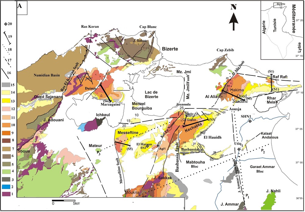
Geological map: Location of studied field sections 1. Trias; 2. Jurassic; 3. Lower Cretaceous; 4. Upper Cretaceous; 5. Palaeocene; 6. Eocene; 7. Oligocene; 8. Serravallian (Hakima Fm.); 9. Serravallian (Oued Melah Fm.); 10. Tortonian (Kechabta Fm.); 11. Messinian (Oued Bel khedim Fm.); 12. Messinian (Chaabet Et Tabbala Fm.); 13. Lower Pliocene (Raf-Raf); 14. Upper Pliocene (Porto Farina Fm.); 15 Quaternary; 16. Major faults detected; 17. Major detected fault; 18. Seismic profile; 19. Geological section; 20. Oil well.
Carte géologique et localisation des coupes et des sections sismiques étudiées : 1. Trias ; 2. Jurassique ; 3. Crétacé inférieur ; 4. Crétacé supérieur ; 5. Paléocène ; 6. Eocène ; 7. Oligocène ; 8. Serravallien (Fm. Hakima) 9. Serravallien (Fm. Oued Melah) ; 10. Tortonien (Fm. Kechabta) ; 11. Messinien (Fm. Oued Bel Khédim) ; 12. Messinien supérieur (Fm. Chaabet Et Tabbala) ; 13. Pliocène inférieur (Fm. Raf Raf) ; 14. Pliocène supérieur (Fm. Porto Farina) ; 15. Quaternaire ; 16. Faille majeure détectée ; 17. Faille majeure supposée ; 18. Profil sismique ; 19. Section géologique ; 20. Puits pétrolier.
Although numerous studies have been conducted and published on the Neogene deposits in northern Tunisia (El Euch-El Koundi et al., 2009; Harrab et al., 2010; Melki et al., 2011; Moissette et al., 2010), few studies have attempted to document the geodynamical conditions during the Messinian Salinity Crisis. Our intent is to help understanding the processes that have led to the initiation of the MSC, and the type of the depositional environment where the Messinian evaporites have been deposited in that portion of the Mediterranean Sea (Bizerte area) corresponding to the Bizerte basin. We will examine these questions through an exhaustive geodynamical study of the Bizerte basin and its evolution during the Neogene time.
2 Material and methods
The Messinian series have been studied using a multidisciplinary approach associating lithostratigraphical with sedimentological and structural analyses, coupled with a cartographic interpretation of the geometry of the structures, involving those of the Neogene series. To perform these studies, we carried out a detailed cartography (1/25,000) of the study area, measured several sections across it and examined and interpreted four seismic profiles (Fig. 1).
A detailed and complete geological study over all the Bizerte basin has led us to realize a detailed geological map (1/25,000) where new interesting observations are reported regarding the tectonic and the structural setting of the study area. Several detailed observations on a small scale have been conducted to identify and to classify the fault networks in the area and to try understanding the role of these faults on the sedimentation as well as on the compartmentalization of the area during the Neogene time.
As a support to this cartographic work and in order to help understanding the lateral and vertical facies distribution of the Neogene series across the study area, we measured six cross sections (Fig. 1). They are as follows: Douimis–Marzaguine (S6), Messeftine (S5), Oued Galaa (S4), Kechabta (S3), Hakima-Saadane (S2) and Raf Raf (S1). In addition and in order to complete our observations, we described two petroleum exploration wells (El Haroun well [EH 3]) and Utique Well (UTQ 1) drilled in this area.
Finally, and in order to implement our study, we interpreted three seismic profiles shot in the study area; one north–south-trending profile termed P1, and two east–west-trending profiles termed P2 and P3 (Fig. 1).
3 Geological setting
3.1 Stratigraphy
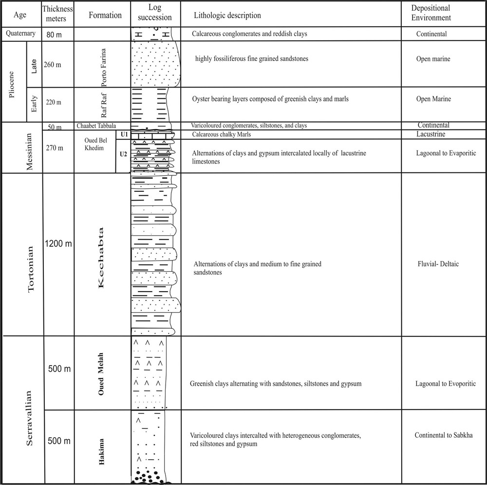
The lithostratigraphical characteristics of the series outcropping in the study area as deduced from the lithostratigraphic Hakima-Oued Saadane log (Fig. 2) allow us to subdivide the Neogene succession into six Formations, which are from bottom to top.
Lithostratigraphy and subdivision of the Neogene series of Bizerte basin (Hakima Mountain–Saadane River).
Séries néogènes du bassin de Bizerte (Oued Saadane–Jebel Hakima).
3.1.1 The Hakima Fm (in Hakima Mountain)
It consists of a 570 m thick lagoonal series made up of variable and weathered clays, silts and sand, red or black marls that admit gypsum intercalations (Ben Ayed, 1993; Burollet, 1951). The Hakima Fm. has been dated Burdigalian–Serravallian by Burollet (1951) and Mejri et al. (2006).
3.1.2 The Oued El Maleh Fm
It consists in a 300 m thick evaporitic sequence made up of grey-greenish marls, passing upwards to lens-shaped to massive gypsum beds. This formation has been dated Serravallian by Burollet (1951) and Mejri et al. (2006).
3.1.3 The Kechabta Fm
It consists in an open marine thick series (2000 m) made up of alternations of flysch like series, clays, sandstones and siltstones (Ben Ayed, 1993; Burollet, 1951; El Euch-El Koundi, 2007; El Euch-El Koundi et al., 2009; Harrab et al., 2010; Moissette et al., 2010). This formation was deposited in a shallow but highly subsiding marine environment (El Euch-El Koundi, 2007) and has been dated as Tortonian in age, by Burollet (1951), and Mejri et al. (2006). However, in a recent study, El Euch-El Koundi et al. (2009) pointed out that the top of this Fm. belongs already to the Early Messinian.
3.1.4 The Oued Bel Khedim Fm
It consists in a margin-littoral to lacustrine series made up of two units (Figs. 2 and 3):
- • a basal gypseferous and marly unit (Unit U2, 220 m thick) composed of a saccharoid gypsum bed overlain by alternations of grey argillaceous marls interbedded with gypsum beds. The marls contain small oyster shells, corals (Siderastraea kckatensis) (Burollet, 1951), and various mollusc shells including Ostrea edulis and Lithophaga lithophaga. Such a lithology indicates a marine margin-littoral depositional environment;
- • and a top calcareous unit (Unit U1, 50 m thick) made up of chalky soft calcareous beds, overlain by grey to black marls alternating with calcareous chalky marls. Unit 2 displays variable thickness across the study area. Facies analysis attests that this carbonate unit is made up of a lacustrine highly porous chalky calcareous material, changing laterally and locally (toward the southeast), into an oolithic fossiliferous limestone, where it indicates a more open shallow marine depositional environment.
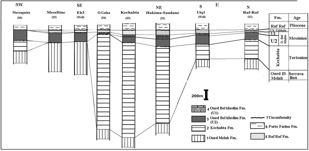
Proposed correlation between the Late Neogene series of the Bizerte basin. 1. Marls and gypsum of the Oued El Melah Formation; 2. Clays and weathered siltstones (Kechabta Formation); 3. Clays and gypsum of Messinian (Oued Bel Khédim Formation, term a) 4. Oolithic and lacustrine limestones of Messinian (Oued Bel Khédim Formation, term b); 5. Conglomerates, silts and sands of the Late Messinian (Chaabet Et Tabbala Formation); 6. Marls of the Zanclean (Raf Raf Fm.); 7. Fault. 8. Unconformity, A. Duimis; B. Messeftine; C. Eh3; D. Kechabta-1; E. Kechabta-2; F. Utq-1; G. Raf-Raf.
Corrélation des séries du Miocène supérieur du bassin de Bizerte. 1. Marnes et gypses de la Formation Oued El Melah ; 2. Argiles et grès de la Formation Kechabta ; 3. Argiles et gypses de l’unité évaporitique (U2) de la Formation Oued Bel Khédim ; 4. Calcaires lacustres et calcaires oolithiques de l’unité carbonatée (U1) de la Formation Oued Bel Khedim ; 5. Conglomérats, silts et grès rouges de la Formation Chaabet Et Tabbala ; 6. Marnes de la Formation Raf Raf ; 7. Faille ; 8. Discontinuité sédimentaire.
The Oued Bel Khedim Fm. has been dated as Messinian by Burollet (1951). El Euch-El Koundi et al. (2009) have dated this Fm. as Early Messinian, by NN11b nannofossils, in two localities: Jebel Messeftine and Jebel Kechabta.
3.1.5 The Chaabet Et Tabbala Fm.
It consists in a continental succession composed of red siltstones, polygenic conglomerates and breccias. This formation is 50 m thick and has been attributed to the Pontian, which is a local continental facies (Ben Ayed, 1993, 1996). However, following El Euch-El Koundi et al. (2009), we attribute the Chaabet Et Tabbala Fm. to the Late Messinian, based on the presence in this formation of basaltic dykes that have been dated as Late Messinian (Bajanik, 1973; Crampon, 1973; El Euch-El Koundi et al., 2009; Harrab et al., 2010; Jaafari, 1997; Mannai-Tayech, 2006; Mejri et al., 2006; Talbi et al., 2005).
In northern Tunisia (Bizerte area), Oued Bel Khedim Fm. and Chaabet Et Tabbala Fm., both belong therefore to the Messinian, and constitute the two terms of what is commonly known as the Messinian Salinity Crisis (MSC) episode around the Mediterranean peripheral basins.
3.1.6 The Raf-Raf Formation
It consists of a marine series mainly composed of green clays embedded with coquinas and oyster bearing levels. The Raf-Raf Formation (300 m thick) is transgressive and lies unconformable above the Chaabet Et Tabbala continental Formation. It has been dated as Early Pliocene (Zanclean) (Burollet, 1951; Burollet and Rouvier, 1971; Rouvier, 1985).
The examination of the lithostratigraphic Neogene succession clearly indicates that, in the Bizerte basin, the Messinian evaporitic deposits display all the characteristic of margin-littoral to lacustrine shallow marine deposits followed, during the Late Messinian, by the deposition of a typical fluvial continental material. It is, however, interesting to point out that, in the Bizerte basin, the Messinian margin-littoral to lacustrine to continental deposits overly unconformably the open marine Tortonian series of the Kechabta Fm. and are overlain unconformably by the Zanclean transgressive marine series of the Raf Raf Fm. Accordingly and as regards the MSC episode, the latter seems to have been initiated as a consequence of a dramatic fall in sea-level followed by a complete desiccation of that Tunisian portion of the Mediterranean Sea.
3.2 Facies correlations and distribution
Facies correlation has been attempted based mainly on facies analysis and also on stratigraphic data collected through the synthesis of previous studies (Ben Ferjani et al., 1990; Burollet, 1951; Burollet and Rouvier, 1971; El Euch-El Koundi et al., 2009; Mejri et al., 2006; Moissette et al., 2010; Rouvier, 1985). As illustrated in Fig. 3, six lithostratigraphic sections (S1 to S6) and two wells (Eh3 well and Utq1 well) have been correlated, allowing the following interpretations.
In the areas of Messeftine and El Haroun (EH#3 well), located to the southwest of the study area (Fig. 1) a marked hiatus caps the regressive pre-Messinian sequences, where the Messinian transgressive sequence is found to directly overly the Serravallian Oued El Melah Formation with a lack of the Tortonian Kechabta sequence. This hiatus obviously resulted from a local up-lift of the area of Messeftine, thus causing the non-deposition of the Tortonian Kechabta Formation.
Further northwestwards (Merzaguine-Douimis area) and further northeastwards (Kechabta–Hakima–Saadane area), occurs a continuous succession showing, from bottom to top, the Serravallian Oued el Melah sequence overlain conformably by a thick Tortonian Kechabta sequence and passing upwards to the transgressive sequence of the Messinian Oued Bel Khedim Formation. Therefore, during the Latest Tortonian, those areas contrast with the Messeftine-El Haroun zone in the way that they have acted as downlifted areas, obviously under the effect of normal antithetic faulting generating horst and graben structures. Within the grabens, (i.e. the Kechabta-Hakima-Saadane graben), the succession is complete and the Messinian is found to overly a continuous and thick Serravallian to Tortonian succession (Fig. 3).
Further northeastwards (Utique and Raf-Raf area), we evolve again toward an uplifted horst during the Tortonian, as clearly expressed by the significant thickness reduction of the Tortonian Kechabta Formation sequence compared to the one in the graben areas.
A detailed examination of the lithologies of the Messinian sequences along the lithostratigraphic profiles (Fig. 3) clearly shows that these lithologies display locally facies and thickness lateral variations, thus attesting that the area remained under a close structural fault control. This is especially expressed by the lateral facies and thickness distribution of the lacustrine calcareous term (unit 1) across the study area.
Indeed, the Saadane River's section (S2) located south of Hakima Mountain shows that the calcareous bed (Unit 1), is 60 m thick and displays all the characteristics of a lacustrine-type facies (Fig. 3), while in the El Galaa River section (S4), located further southwestards, between the Kef en Nsour-Sfaya fault and the Alia-Sakkak fault (Kechabta-1, Figs. 1 and 3), the calcareous bed is only 30 m thick and is found to be oolithic, thus indicating that it has been obviously deposited in a more open marine shallow environment. Further southwestwards, the calcareous bed is only 2 m thick and its depositional environment is again lacustrine, as attested to by its chalky composition. More to the northwest (Merzaguine-Douimis S6), the calcareous bed of Unit 1 is totally absent and the continental fluvial deposits of the Chaabet Et Tabbala Formation directly overly the gypseferous marls of Unit 2. Such facies and thickness lateral variations affecting the calcareous bed of the Messinian Oued Bel Khedim Formation (Unit 1) are interpreted as related to the combined effect of tectonic activity and eustatic fall in sea level. We propose that successive eustatic pulses combined to a tectonic activity that had controlled the sedimentation and the subsidence rate within the fault tilted basins are responsible for lateral changes in lithofacies and thicknesses.
As regards the facies and thickness lateral variation affecting the upper term of the Messinian sequence (i.e. the continental Chaabet Et Tabbala Formation), the following observations could be pointed out. In the Hakima section (S2), located to the north-east, this formation is found to overly the Oued Bel Khedim Formation, and displays a thickness of only 50 m (Burollet, 1951; El Euch-El Koundi, 2007; El Euch-El Koundi et al., 2009) while further southwestwards, at the eastern termination of the Kechabta anticline (Fig. 3), its thickness increases to reach 70 m. Once again, we interpret such variations in thickness as due to the tectonic control of the sedimentation.
Finally, as regards the transgressive Early Pliocene Raf- Raf Fm., no facies and lateral thickness variation could be pointed out at a regional scale, thus attesting that the Pliocene sedimentation was mainly induced and controlled by a global eustatic rise in sea level due to the reflooding of the Mediterranean Sea.
3.3 Structure and tectonic results
The examination of the geological map (Fig. 1) allows pointing out the following observations:
3.3.1 The fold structures
Fold structures cropping out in the study area involving the Neogene succession, group (Fig. 1):
- • a series of anticline folds the axes of which are oriented roughly north-east–south-west. They are, from southwest to northeast: Jebel Moukna-Sakkak, Jebel Kef Nsour-Kechabta, Jebel Hakima-Saadane, and Raf Raf anticlines. In fact, these folds are parts of one and unique mega-anticline structure trending NE–SW, crossed along its core axis by the northeast–southwest El Alia fault, discontinuously injected by Triassic evaporite materials, like in Jebel Moukna and in Jebel Kef Nsour. This fault runs roughly parallel to the mega-anticline axis structure;
- • east of Mateur city, the Messftine anticline structure, whose axis is also trending NE–SW, outcrops. This anticline is separated from the mega-anticline fold documented above by the syncline structure of El Haroun area;
- • further westwards, the anticline structure of Jebel Douimis, whose axis is also trending SW–NE, outcrops. This anticline is separated from the Messftine anticline lineament by the Garaat Ichkeul plain.
3.3.2 Fault systems
The fault system network identified in the study area associates several directions, which are thought to have played a key a role in the structuring of the Neogene basins as well as on the control of the sedimentation during the Neogene.
Fig. 4 displays good exposures of synsedimentary faults (Photos A, B and C), reported from the Oued Saadane area (section S2, Fig. 1). A detailed examination of these photos clearly shows a synsedimentary normal faulting of various directions affecting gypsum beds with a decimetric to metric displacement of the Oued Bel Khedim Formation. Fault plans examination also clearly shows indications that these synsedimentary faults are sealed and are of tectonic origin, as demonstrated by the normal crochons, well expressed for example in Photos A and B.
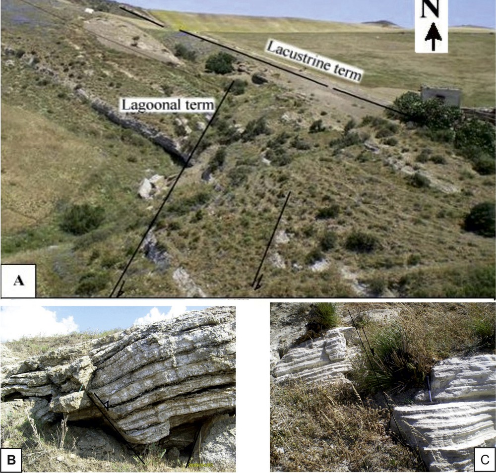
Messinian normal fault: A: synsedimentary Messinian normal fault N30 affecting the lagoonal term in the Saadane River; B: Synsedimentary Messinian normal fault N70 in the Oued Saadane; C: Syn-Messinian normal fault N60 affecting the gypsum of Oued Bel Khedim Formation in the area of Messeftine.
Failles normales synsédimentaires affectant les dépôts gypseux du Messinien au niveau de l’oued Saadane (A et B) et au niveau de Messeftine (C).
Similar typical synsedimentary faults could also be seen in many other field areas such as Messeftine (section S4, Fig. 1) and Kechabta (section S3, Fig. 1).
The general fault network in the study area might be divided into four different systems: the NE–SW fault system, the north–south fault system, the east–west fault system and the NW–SE fault system:
- • the NE–SW Fault system represents a major direction in the area. Movements along these faults varied in time from extensional to reverse and/or thrust in. The interpreted seismic profiles and lithostratigraphic (Figs. 3 and 5) demonstrate well that these faults have controlled sedimentation during the Messinian and the Pliocene. Also, they are marked with Triassic salt, which is an evidence of their importance;
- • the north–south fault system is largely represented in the study area, and is thought to have played a key role in controlling the sedimentation and the subsidence rate during the Neogene. The most important are: the Jebel Ammar-Utique fault, the Menzel Jmil fault, the Bassebassia fault, and the Messeftine fault (Fig. 1). The final Plio-Quaternary movement of these faults is most likely senestral. This is indicated by striated plans well inspected in the west of the Messeftine and Besbassia areas. The change in fold axis direction of Messeftine and Mokna (NE–SW to north–south) in addition to the absence of the western periclinal termination of Messeftine fold, is related to the senestral movement of the Messeftine fault synchronous to the fold edification;
- • the east–west fault system is represented in the study area by two main faults: the Menzel Bourguiba-Ghar El Melh fault and the Hakima-Raf-Raf fault. The apparent movement along these two faults is strike slip dextral, having dramatically affected the NE–SW major lineament, causing a kilometric displacement of its axis toward the east (Ben Ayed, 1993);
- • NW–SE faults are also present in the Bizerte area. They have acted as normal in the foreland domain of the Alpine belt. They were active during the Neogene and particularly during the Uppermost Miocene. These faults limit the zones in depression and accordingly are responsible for the great thickness of the Mio-Pliocene series.
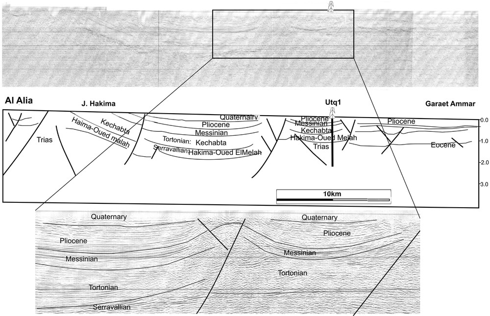
Interpreted seismic profile (P1): Messinian series (Oued Bel Khedim. and Chaabet Et Tabbala Fms.) disconformably overlying the Serravallian–Tortonian (Oued El Melah and Kechabta Fm.) permutation of depocentres; zoom showing the inverse fault and the variation in thickness of both sides of the fault.
Interprétation du profil sismique (P1) : variation des épaisseurs des séries messiniennes de part et d’autre des failles majeures.
3.4 Seismic data
This paragraph will document the interpretation of the four seismic profiles P1, P2 and P3 shot in the area, respectively trending north–south for P1 and WSW–ENE for P2 and P3 (Figs. 5–7).
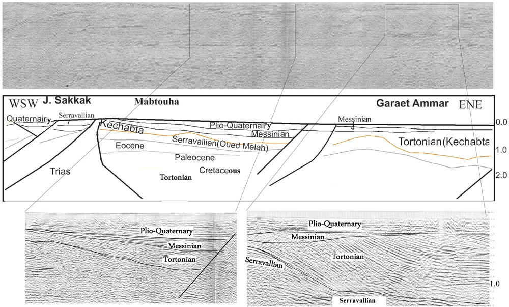
Interpreted seismic profile (P2): Messinian series (Oued Bel Khedim. and Chaabet Et Tabbala Formation) disconformably overlying the Serravallian–Tortonian (Oued El Melah and Kechabta Formation); zoom showing the permutation of depocentres of both sides of the fault
Interprétation du profil sismique (P2) : discontinuité entre les séquences messiniennes et les séries sous-jacentes (Éocène–Serravallien). Zoom montrant la permutation des dépocentres de part et d’autre des failles majeures.
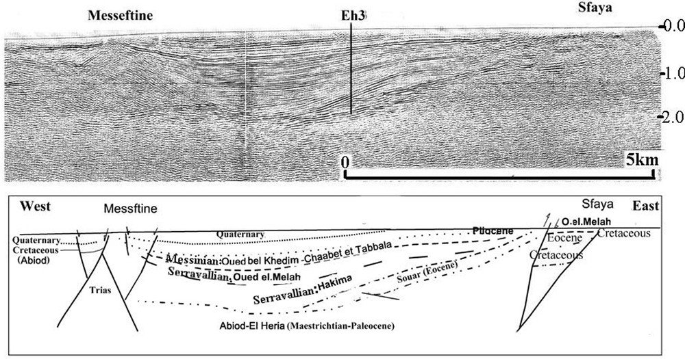
Interpreted seismic profile P3: Messinian series (Oued Bel Khedim. And Chaabet Et Tabbala Formation) disconformably overlying the Serravallian (Oued EL Melah Formation) and the Hiatus Tortonian (Kechabta Formation).
Interprétation du profil (P3) : lacune de la Formation Kechabta. Dépôts messiniens en discontinuité sédimentaire sur les séries serravalliennes.
3.4.1 Interpretation of P1 seismic profile
The examination of the P1, north–south-trending seismic profile (Figs. 1 and 5) allows us to point out the following observation: the first observation deals with the presence of several NE–SW-trending faults with a reverse movement. However, it is clear from this profile that from each side of these faults, the Messinian series exhibit significant thickness lateral variations, thus attesting to their normal character during this period.
Once again, the interpretation of this profile shows the great role played by tectonic and fault systems in Neogene sedimentation, and particularly in the Messinian.
3.4.2 Interpretation of P2 seismic profile
The examination of the WSW–ENE P2 seismic profile (Figs. 1 and 6) leads us to the following observations:
- • the first one confirms the existence of the major unconformitiy, already documented, between the Messinian sequences and various pre-Messinian (Eocene-Serravallian) series, as it is clearly visible on the western and the eastern parts of the profile;
- • the second one deals with the clear inversion of the subsidence rate at the passage from the Kechabta Fm. to the Oued Bel Khedim Fm. under the control of two major faults, cut tree blocks: During the pre-Messinian period, the Garaet Ammar block to the east and the Mokna block to the west were very subsident compared to the Mabtouha block, whereas the latter is highly subsident during the Messinian, where it shows the highest thicknesses. The Sakkak area presents a salt dome which obviously has acted during all the Neogene time as a palaeohigh, on which both the Messinian Oued Bel Khedim Fm. and the Serravallian–Tortonian Kechabta Fm. are highly reduced. This once again demonstrates the active role of the tectonics in controlling the sedimentation and the subsidence rate during the Neogene period and especially during the Messinian.
3.4.3 Interpretation of P3 seismic profile
The examination of the P3 WNW–ENE seismic profile (Figs. 1 and 7), which runs sub-parallel to the P3 profile and which passes through Eh3 well, shows a marked hiatus between the Messinian series and the underlying Serravallian Oued El Melah Fm., expressed by the absence of the Tortonian Kechabta Fm. To the top, and as shown on the lithostratigraphic log of El Haroun#3 well, the Messinian sequence, is composed of the margin-littoral to continental Oued Bel Khedim–haabet Et Tabbala Formations and is overlain unconformably by the Pliocene marine series of the Raf Raf Formation. The detailed examination of the succession in El-Haroune#3 well log, combined with the interpretation of the P3 seismic profile, clearly indicates a non-deposition of the Kechabta marine Fm., due probably to a tectonic uplift of the area at the end of the Serravallian time.
4 Discussion
During the Upper Tortonian, a major compression episode seems to have prevailed all over the Mediterranean Basin and caused the folding of the eastern Maghrebides (Babault et al., 2005; Caire, 1973; Durand-Delga, 1980; Durand-Delga et al., 1989; Dlala, 1994, 1996; Durand-Delga and Fontboté, 1980; Kacem, 2004; Roure et al., 2012; Zargouni, 1985). This compression episode was followed, during the Messinian, by a NW–SE-trending extension that caused a tectonic inversion and the reactivation of the normal faults (Ben Ayed, 1996; Melki et al., 2010, 2011; Philip, 1983; Weijermars, 1988; Zouaghi et al., 2011).
Our tectonic analysis conducted in the area enabled us to recognize distensive tectonics that guided sedimentation during the Messinian.
This tectonic inversion is well expressed through the unconformity identified and documented between the latemost Tortonian (Kechabta Fm.) and the Early Messinian (Oued Bel Khedim Fm.), from the lithostratigraphic correlations of the series representative of the different faulted blocks (Figs. 3 and 4) as well as from the interpretation of seismic profiles (Figs. 5–7).
It also demonstrates the active role played by the reactivated normal faulting in inducing the tectonic inversion of structures and the control of the sedimentation and the subsidence rate within the Messinian depositional basins. The distensive tectonic Messinian regime generated the reconstruction of the basins into tilted blocks toward the east and where the sedimentation and subsidence rates have been under the close control of the faults bounding the blocks (Figs. 5–7).
All the examined seismic profiles confirm the existence of the unconformity between the marine Pliocene Raf-Raf Fm. and the Messinian Oued Bel Khedim–Chaabet Et Tabbala Formations.
Prior to the deposition of the Raf-Raf marine Fm., an active erosion event had been reported by (Euch-El Koundi et al., 2009). Especially, El Euch-El Koundi et al. (2009) brought evidence of the occurrence of such an event in northern Tunisia, through the interpretation of two offshore seismic profiles, located further east of the onshore Neogene basin. In our case, we have no doubtless proof of this erosion phenomenon but, through our observation of the ENE part of the profile, we only notice that the Pliocene Raf Raf Fm. directly overlies the Tortonian Kechabta Fm. with a lack of the entire Messinian sequence (Oued Bel Khedim and Chaabet Et Tabbala Fms.). Therefore, we suggest that the lack of the Messinian series is probably related to an erosion phenomenon.
Sedimentologically speaking, the Messinian evaporitic series termed Oued Bel Khedim Formation displays in the Bizerte area a composition that reflects proper depositional environment. Data and results collected from the lithostratographic and geodynamical studies conducted on the Bizerte zone at a regional scale show that the Messinian series of Oued Bel Khedim Formation (230 m) is a prograding sequence composed of three different units that are, from bottom to top: a lagoonal (unit U2), composed of marls and interstratified gypsum beds, grading upwards to a lacustrine (unit U1) composed of chalky limestone (locally oolithic shallow open marine), and the whole is capped by the fluvial continental deposits of Chaabet Et Tabbala Formation, made up of continental detrital and conglomeratic beds including locally volcanic basic resedimented materials. No salt has been identified within the Messinian sequence in outcropping series or in the subsurface (in oil wells).
This margin-littoral Messinian sequence has been deposited unconformably on the marine Tortonian Kechabta Formation, and is overlain unconformably by the marine Pliocene series of the Raf-Raf Formation.
Its lithology clearly indicates that the depositional environment evolved from a shallow marine restricted environment (probably of sebkha type) to a more restricted lacustrine environment then to a continental fluvial environment. Such a prograding sequence is thought to result from the dual effect of an eustatic fall in sea level accompanied by an extensive tectonic control of the sedimentation.
Finally, the change observed locally within the calcareous unit b of the Oued Bel Khedim Formation, from chalky lacustrine facies to oolithic shallow open marine facies, points at least locally to an eustatic sea-level rise or/and a local tectonic activity. These series ended in the Late Messinian event by the deposition of the continental Chaabet Et Tabbala Formation.
5 Conclusions
Northeastern Tunisia (Bizerte area) represented during the Messinian Salinity Crisis a branch of the western Mediterranean domain where a restricted shallow marine sedimentation composed mainly of clays, gypsum and carbonate materials, typical of a lagoonal to lacustrine depositional environment, took place. Within this basin, sedimentation was closely controlled by eustatic fall in sea level and also by tectonic activity.
In northern Tunisia, sedimentation during the Messinian was guided by an extensional tectonic regime expressed by normal faults oriented NE–SW to north–south. These faults, well expressed on the surface and the subsurface, have bounded blocks showing significant lateral facies and thickness lateral variations.
Two different regressive-transgressive cycles have been identified: the first one is materialized by the Tortonian/Messinian unconformity, while the second one is shown through the top Messinian/Pliocene unconformity. Successive eustatic pulses combined with tectonic activities have been the major control of sedimentation and subsidence rates within the Mio-Pliocene fault tilted basins across the Bizerte area and believed to be responsible for lateral facies and thickness changes.
So far, we have no tangible proof in our study area (outcrop and subsurface) as it is the case in neighbouring regions of the Mediterranean, of erosion phenomena, which have probably affected the Upper Messinian. However, angular discordances related to tectonic deformations which have probably generated palaeohigh and emerged zones, as well as the continental conglomeratic facies (Chaabet Tabbala Formation) can be considered as indicators of an erosion phenomenon.