

1 Introduction
The Gulf of Tunis located in north-eastern Africa constitutes the extension of the Tunisian Atlas to the south and the Tell-system to the north and corresponds to a relay-zone with the Siculo-Tunisian strait (Fig. 1 A). It shows the continuation of the tectonic and sedimentary structures recognized at the Cap Bon Peninsula, Tunis, Kechabta, Ghar El Melh, El Alia and Bizerte areas (Fig. 1B). In spite of the many works known about the northern Tunisian trough (Bedir et al., 1996; Ben Ayed, 1993; Boutib et al., 2000; El Euch, 2008; El Ouardi and Turki, 1995; Kacem, 2004; Martinez and Truillet, 1987; Salaj, 1980; Soussi, 2003; Turki, 1988) and the Tellian zone (Crampon, 1973; Melki et al., 1999; Rouvier, 1977), the Gulf of Tunis remains an unknown area concerning its tectono-sedimentary history.
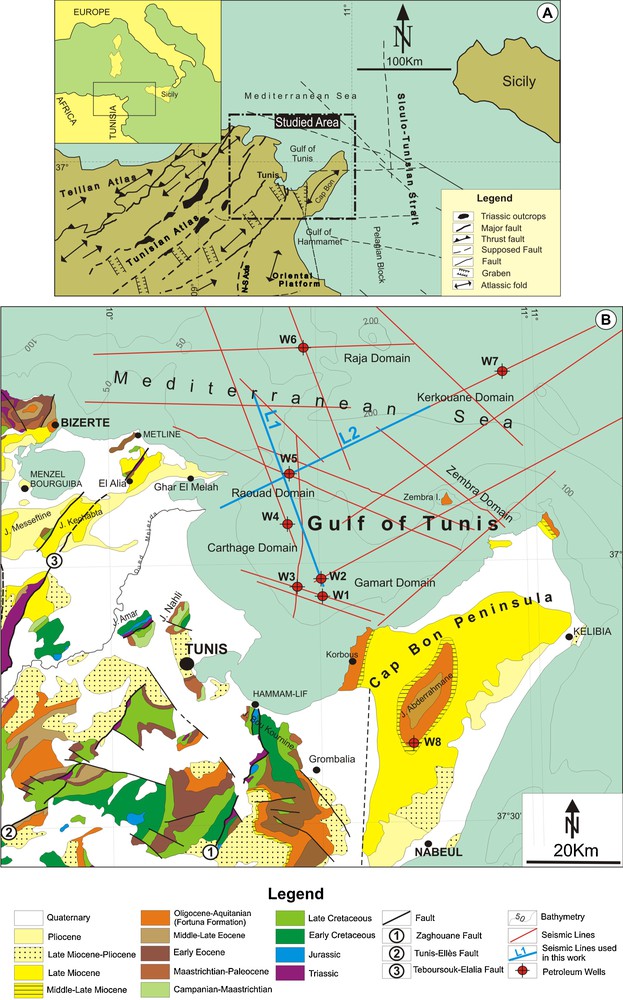
A. Geographic and geological situation of the studied area in the Mediterranean domain. B. Geologic map of the onshore north-eastern Tunisia outcrops and Bathymetry of the Gulf of Tunis. This map shows the position of used petroleum wells and seismic lines.
A. Cadre géographique et géologique du secteur d’étude dans le domaine méditerranéen. B. Carte géologique des affleurements de la Tunisie nord-orientale et bathymétrie du Golfe de Tunis. Cette carte montre la position des forages pétroliers et les lignes sismiques utilisées.
The geodynamic evolution of the Mediterranean basins has been considered to be related to Africa and Europe motions and a consequence of different spreading rates along the Atlantic oceanic ridge (Guiraud, 1998; Piqué et al., 1998). Since the Late Triassic to Present, the North African domain has undergone episodes of deformation that can be correlated to plate kinematics; these movements are fossilized in the sedimentary deposits (Bouaziz et al., 2002). The Gulf of Tunis shows paleogeographic continuity of the known onshore sedimentary deposits and records the tectonic movements, as well as the regional sedimentary events. These tectonic and sedimentary events follow the major orogenic phases, which resulted from convergence movements between the African and Eurasiatic plates (Biju-Duval, 1977; Bouillin, 2000; Casero, 2004; Casero and Roure, 1994; Durand-Delga, 1980; Guiraud, 1998; Torelli et al., 2000). These are induced by compressive tectonic constraints, beginning since the end of Late Cretaceous times (Alvarez, 1991; Doglioni et al., 1999; El Euch et al., 2004; Frizon de Lamotte et al., 2008; Guiraud, 1998; Mascle et al., 2004; Tricart et al., 1991). This orogenesis has created, on the Mediterranean borders, many chains and mountains linked to Corsica and Apennines, in the east, to the Balearic Islands and the Betic Cordilleras, in the west (Catalano et al., 2000; Doglioni et al., 1999; Frizon de Lamotte et al., 2006).
The various geological works completed in northern Tunisia and in the Siculo-Tunisian strait (Ben Ayed, 1993; Ben Chelbi et al., 2006; Burollet, 1951; Chihi and Philip, 1998; Jauzein, 1967; Letouzey, 1986; Rekhiss, 2007; Sartori et al., 2001), indicate the importance effect of the NE-SW, north-south and NW-SE faults on the control of sedimentation during the Tethyan rifting and, thereafter, on the structuring of the central and northern Atlas domains during the Pyrenean and Alpine/Atlasic polyphasage (Fig. 1).
The Triassic rifting phase was especially ensured by the rejuvenation of NE-SW Hercynian faults. The Zaghouan major fault delimits the subsiding trough on the southeastern side (Turki, 1988). The rifting was continued during the Jurassic (Soussi, 2003) and the Early Cretaceous, causing formation of grabens, half-grabens and synclines, separated by horsts structures. During the same period, other major lineaments (Tunis-Ellès and El Alia-Teboursouk faults), located at north-western Zaghouan master fault, have also controlled the sedimentary distribution (Ben Chelbi, 2007; Perthuisot, 1978; Zargouni, 1977).
The compressive events, especially recorded in the Middle and Late Eocene (Lutetian-Priabonian), Late Miocene (Tortonian) and Late Pliocene-Quaternary (Villafranchian) resulted in the NE-SW Atlasic folds and reverse faults. These compressive events are alternated by short extensional periods during the Oligocene-Aquitanian (Ben Ayed, 1993; Perthuisot, 1978; Talbi et al., 2008) and the Messinian-Early Pliocene (Melki, 1997). The subsiding trough faults and symmetric/asymmetric grabens have an orthogonal position (NW-SE) compared to the Atlasic structures (Ben Ayed, 1993; Chihi and Philip, 1998) and the Neogene basins (molassic basins). The Triassic domes and the diapir zones are generally lengthened NE-SW (Perthuisot, 1978; Rouvier, 1977).
2 Dataset and methodology
Study of the Mesozoic and Cenozoic successions in the Gulf of Tunis is mainly based on seismic interpretation of 2D seismic lines acquired by several oil companies (ETAP, SEREPT, Geco Prakla, CGG, Maxus Energy, Shell, Agip…) and provided by the ETAP Company. Lithostratigraphical analysis was carried out using time-depth conversion of lithologic data from W1 to W8 petroleum wells (in the text, names of the offshore structural domains are drawn from names of the boreholes, which will be referred to as Wn because of the confidentiality of the data).
Thickness and facies changes of deposits and important stratigraphic hiatuses were identified by the development of seismic sequence stratigraphy. Analysis and correlation of seismic facies allowed us to define the seismic units bounded by unconformities (erosion and hiatuses) identified by toplap and downlap/onlap discontinuity surfaces. These units provide a seismic stratigraphy framework to constrain the depositional and tectonic evolution of the basin.
This subsurface study aims to determine the tectono-sedimentary events and to specify the structural evolution of north-eastern Tunisia. It enables us to follow the different structural zones and propose the location of the ancient outcrop and major lineaments in the Gulf of Tunis. We intend, to check and follow the known onshore Tertiary major tectonic events and to find the structural and sedimentary records in the immerged zone of Gulf of Tunis.
3 Structural framework and tectono-stratigraphic events
3.1 Structural pattern
Seismic sections carried out in the Gulf of Tunis provide an opportunity to compare the age and the geometry of the offshore structures. The study area is divided into distinct sectors that coincided with structural lineaments that formed major paleogeographic zones during Mesozoic and Cenozoic periods.
The trends of the major basement faults are similar to those recorded in the onshore Atlas of Tunisia. Two distinct sets of faults are recognized in the offshore of the Gulf of Tunis area; the primary set includes NE-SW trending faults, while the secondary set is NW–SE striking.
3.1.1 NE-SW features
The Gulf of Tunis consists of the northeast-southwest trending folds generally bounded by the steep reverse faults and associated with deep asymmetric geometries that are organized into depressions and uplifts (Figs. 2–4). The parallel and ancient faults have a subvertical geometry in the Mesozoic and Cenozoic sedimentary cover and a bending and converging style in the depth showing a positive flower structure.
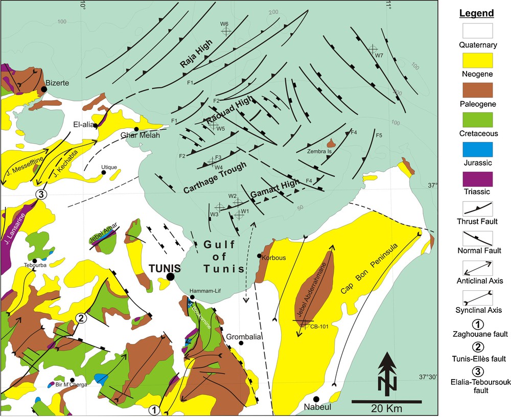
Structural map of the studied area showing the main surface and subsurface tectonic features.
Carte structurale du secteur d’étude montrant les principaux alignements tectoniques de surface et de subsurface.
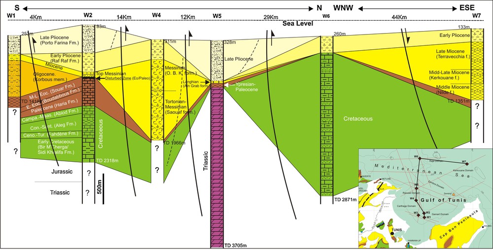
Lithostratigraphic correlation of the well data in the Gulf of Tunis, showing the inversion of subsidence at the Top Cretaceous, Top Miocene and Top Early Pliocene.
Corrélation lithostratigraphique des données des forages dans le Golfe de Tunis, montrant l’inversion de la subsidence au Toit du Crétacé, Toit du Miocène et Toit du Pliocène inférieur.
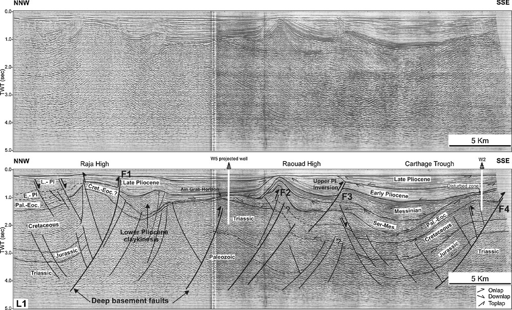
Interpreted seismic line L1 of the Gulf of Tunis (location shown in Fig. 1), illustrating distribution of the Mesozoic and Cenozoic depositions and their evolution towards the NE-SW faults and associated Triassic salt rising. F1–F4 major faults are presented in Fig. 2.
Ligne sismique interprétée L1 du Golfe de Tunis (localisation voir Fig. 1), illustrant la distribution des dépôts mésozoïques et cénozoïques et leur évolution vers les failles NE-SW et les ascensions triasiques associées. Les failles majeures F1–F4 sont présentées sur la Fig. 2.
The NE-SW El Alia-Teboursouk system fault corridor has an important control on the Mesozoic and Cenozoic paleogeographic evolution. 2-D seismic lines emphasize contribution of this fault in the structuring and the distribution of the sedimentary deposits. Separation of the western subsiding block (Raja domain) from the other eastern block at the level of the El Alia-Teboursouk fault, suggests their major effects during the different Mesozoic and Cenozoic periods. These results let us to consider it as a deep basement fault.
Another strike-slip faults (Ghar El Melah, Raouad, Gamart) runs NE-SW in the Gulf of Tunis. Elongation of the down-dropped blocks outlines the general trend of the boundary faults. Synthetic and antithetic second order faults and folds that are associated with the master faults display the wrench fault displacement (Fig. 4).
Linear positive flower structures that have steep fault planes and an offset extending into the basement are emphasized by crossing seismic lines that show the deposit sedimentary and tectonic reflection structures and associated Triassic salt intrusions. The borders of the basins are marked by a chaotic seismic facies under the later effect of the intensive deformation. These structures suggest a persistent fault displacement during the Mesozoic and Cenozoic time intervals (Figs. 2–4).
3.1.2 NW-SE features
The Gulf of Tunis offshore area is marked by the presence of depressions that evolve laterally to uplifts. Seismic lines show the asymmetric limbs of the half-grabens, which are bordered by the uplift structures and by cross-cutting fault trends, striking NW-SE. On both sides of these faults, there appears an important variation of thickness that is progressively reduced, and associated with the retrogradational onlap structures towards the high zones (Figs. 2 and 5).
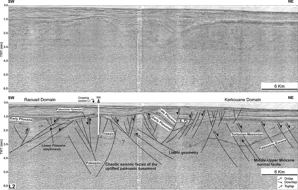
Interpreted seismic line L2 of the Gulf of Tunis (location shown in Fig. 1), illustrating distribution of the Cenozoic depositions and their evolution towards the NW–SE faults and associated Triassic salt rising.
Ligne sismique interprétée L2 (localisation sur Fig. 1), illustrant la distribution des dépôts mésozoïques et cénozoïques et leur évolution vers les failles NW–SE et les ascensions triasiques associées.
The fault pattern exhibits an extensional character. Dip slip of faults trending NW–SE often display a listric geometry, and form synclines and half-grabens structures with synthetical/ antithetical tilted hangingwall blocks. The densest tectonic setting is exposed along the Gulf of Tunis belts that are marked by isolated and discontinuous ridges. The dip slip faults provide the margins of deep grabens with tilted horst blocks. Along the master faults of the grabens, the vertical offset increases, approaching the major escarpments at the border of the uplifted structures (Fig. 5).
In the offshore of the Gulf of Tunis, the movements of basement-related faults have caused halokinesis movements during the distinct phases of Jurassic extension, since salt structures are always associated with faults at depth. Ascension of the Triassic salt facies was continued during the Mesozoic and Cenozoic tectonic events; it has been associated during the Neogene with the Middle to Late Miocene and Early Pliocene claykinesis. These diapir structures occupy the faulted/folded border of basins and participate in the structuring changes and therefore in the geodynamic evolution (Fig. 5).
3.2 Kinematics and sedimentary distribution
3.2.1 Triassic
Its facies is always identified with abnormal stratigraphic position (W5 well) in a zone that corresponds to the eastern extension in offshore to the domes and diapirs zones of the northern Tunisia Atlas (Fig. 1). It shows a huge thickness with an average of 2616 m without reaching the base. The lithostratigraphic column is composed at the Top by 370 m of anhydrites. The facies is essentially formed by carbonates, clays, sandstones and sometimes by anhydrites (Fig. 3).
Because there is no well that reached the base of the Triassic and their chaotic seismic facies, we cannot identify an appropriate deep structure of this interval and, therefore, there is no information on the tectono-stratigraphic control.
3.2.2 Jurassic
The deposits remain unknown in the Gulf of Tunis because there is no well crossing these series. It largely outcrops in the Dorsale mountain range, in the northern Atlas (Alouani et al., 1990; Kammoun et al., 1999; Turki, 1988) (Fig. 1). Its thickness is about 700 m in the northern Tunisian trough (Soussi, 2003) and in the Cap Bon peninsula (W8 well). On the L1 seismic line, the near base of the Jurassic limestones and marls deposits overlays the Triassic carbonates seismic reflector by a downlap prograding deposits on the flanks of highs. It is characterized by the unconformity-condensed surfaces marked by high amplitude and well continuity (Fig. 4).
The sedimentary deposits are reduced on the Gamart platform and diverge towards the down dip. Above, the Middle and Upper Jurassic are formed by the aggradational-retrogradational onlaps on the underlying sequence and associated with angular unconformities toward the uplifted areas. The thickness of the Jurassic deposits varies on both sides of the basin. It is considerably reduced towards the northwestern flank in the direction of the Raouad uplift. The seismic facies is associated with a hiatus that is showed by the onlap/downlap structures and marked by a stratigraphic gap on the Triassic facies. The progradational downlap structures show the irregularity of sedimentary deposits and determine the principal fault effect on the sedimentary lap-out. The sedimentary distribution is controlled by the Triassic-diapirism that is highlighted, in the W5 well by the Jurassic hiatus, where the Paleocene directly deposited on the Triassic (Fig. 3) and, on the seismic sections by wrench salt-intruded fault corridor and by the Triassic exposure structures (Figs. 4 and 5).
3.2.3 Cretaceous
It is composed, by clays, marls, limestones with some layers of sands. These series are particularly thick in the W6 well (2341 m). However, in the W2 and W3 wells, they present, respectively, 912 and 477 m (Fig. 3), indicating structuration into high and low zones under effect of the boundary faults. The seismic section L1 shows that the Upper Jurassic unconformity is a distinct surface characterized by a subtle toplap/onlap patterns. The Cretaceous deposits are rested on the Jurassic, by two double-seismic high amplitude horizons corresponding to the lithologic contrasts between the Jurassic limestones and the Lower Cretaceous alternations. On the slope zone, seismic reflections have the prevailing progradational oblique configurations, which have showed the sedimentary distribution under the effects of the master boundary faults (Fig. 4). Unlike the underlying Jurassic reflectors, the Cretaceous deposits are thickened on the Gamart wrench corridor system and are considerably reduced towards the depocentre, related to the Triassic–diapirism movements, which has caused the structural inversion and the tilting of the uplifted limbs. Towards the Raouad uplifted structure, the sedimentary series are associated with basal retrogradational onlap and progradational toplap. On the Triassic body, all Cretaceous reflectors are an erosional or no depositional unconformity, marked by flat and high amplitude reflections (Figs. 4 and 5).
3.2.4 Paleocene-Eocene
The sedimentary series are formed by three different lithologic formations (Fig. 3); at the base, the El Haria formation (Late Maastrichtian–Paleocene) is composed by marls and clays (W2 well). It is reduced in the W5 well where it directly rests on the Triassic deposits and it misses in the W6 well. The second Boudabous formation (Ypresian–Early Lutetian) is formed by Nummulitic limestone with some argillaceous rate. The last Souar formation (Lutetian–Priabonian) is composed essentially by clays.
The Paleocene–Eocene deposits are unequally distributed in the Gulf of Tunis related to the tectonic deformation of this area. Thickness of these formations varies from 434 m in W2 well, to 307 m in W3 well. We note the absence of the two last formations in the W5 and W6 drillings (Fig. 3). In the Cap Bon outcrops, the Souar formation reached 800 m of thickness (Ben Ismail-Lattrache and Bobier, 1984). Seismic reflectors are bounded by an angular unconformity and represented on the Gamart flank by aggradational/retrogradational onlaps on the top of the Maastrichtian marl and carbonate horizons (Abiod formation) (Fig. 4).
It is a moderately continuous, faulted wedge that pinches out on the Raouad uplift (Fig. 5). The equivalent deposits are marked, in the W2 well by the avalanche breccias (disturbed zone) at the Late Eocene. These structures should indicate a tilting of the sedimentary floor along the faulted zone (Fig. 4). Paleocene–Eocene deposits, which are materialized by a development in the centre of depression and Raouad uplift, are reduced towards the Gamart uplifted limbs, where the El Haria clayey and Boudabous limestones directly deposited on the Triassic evaporates (Fig. 4).
3.2.5 Oligocene–Miocene
In contrast to the previous deposits, the Oligocene–Aquitanian series (Fortuna formation) are locally well developed in the Gamart basin. Only the lower unit that corresponds to the Korbous member (Early to Middle Oligocene), appears in the W1 well with 600 m of thickness but they appear to be absent in all other wells (Fig. 3). This series is represented by clay with silt and sand alternations. The upper unit of the Fortuna formation (Late Oligocene–Aquitanian) is completely missed in all wells of the Gulf of Tunis (Fig. 3). It corresponds to the extension of the SW onshore hiatus (Yaïch et al., 2000). Towards the east, in the Cap Bon, the Fortuna formation outcrops with a thickness of 800 m (Ben Ismail-Lattrache and Bobier, 1984; Yaïch et al., 2000). Seismic analysis shows important hiatuses, essentially, on the top of paleohighs. These series are, on the whole, deposited on the Gamart Ypresian large carbonate platform (Boudabous formation), which are partially eroded (Figs. 3 and 4). The Miocene sedimentary sequences are well developed in the Carthage basin. This subsiding zone shows stacking of one large super-sequence with maximum regression at the top of the Eocene.
The Middle Miocene starts by the lumachellic calcareous bar of the Ain Grab formation (Langhian) and marks the beginning of the Middle Miocene transgression, identified regionally in all Tunisia (Bedir et al., 1996; Ben Ayed, 1993; Ben Salem, 1992; Burollet, 1951; El Euch, 2008; Rekhiss, 2007). This fossiliferous limestone bar is only recognized in the W5 well where it presents 19 m of thickness (Fig. 3). It corresponds, on the seismic lines, to a continuous and high amplitude reflector doublet identified on the seismic line indicating their nature as a regional transgression event (Figs. 4 and 5). Its absence in other areas can be related their erosion. This reduced formation, only defined in the W5 well, could be deposited and thereafter eroded, which explains its absence in the other wells. In the Cap Bon, the Langhian transgression is marked by the presence of conglomerates at the base of the Ain Grab formation (Ben Ismail-Lattrache and Bobier, 1984). Unconformity relating to this transgression could be traced and correlated through all drillings of the Gulf of Tunis and the surrounding outcrops.
The Middle to Late Miocene series identified in the Gulf of Tunis are represented by the Saouaf (Serravallian–Tortonian–Messinian) and the Oued Bel Khedim (Messinian) formations that show a great variation of facies in the Gulf of Tunis area (Fig. 3). These formations are composed by clays and silts and occasionally by sandy limestone at the base and by marls and salts at the top. Regionally, these facies confirm the nature and distribution complexity of these series in the Messeftine, Kechabta, Utique and Cap Bon localities (Ben Salem, 1992; Boujamaoui et al., 2000; Burollet, 1951; El Euch, 2008) and are similar to those of the Mediterranean basin (Burollet, 1951; Cornée et al., 2006; Mannaï-Tayech, 2006; Vecsei and Sanders, 1999). These two formations that have 1313 m of thickness are recognized in the W4 well, where they correspond to a subsiding depocentre in this locality (Fig. 3). They are also identified towards the east in the W7 well accompanied by lateral equivalents (Nilde, Kerkouane and Terravecchia formations) with an average thickness of 1000 m forming a second depocentre. The Middle to Late Miocene deposits are well developed in the Carthage and Kerkouane tectonic structures (Figs. 3–5). Its development could be related to changes in basin floor topography, which is controlled by tectonic movements. Laterally, on the Gamart and Raouad uplifts, these sediments thin, where the Messinian evaporate directly deposited on the Langhian limestone single seismic reflection. Lateral thinning of the strata is associated with the pinch-out of intra-unit packages and intra-unit angular unconformities. At the top, this super-sequence is bounded by a toplap structures and is overlain by a double seismic reflectors corresponding to the Upper Miocene gypsum (Figs. 4 and 5).
3.2.6 Pliocene
In the Gulf of Tunis, the Pliocene deposits that make up the top-most Neogene interval are capped by the major Villafranchian unconformity. The deposits show a huge thickness represented by clays, sands and sandstones. The seismic horizons show variation of thickness and seismic facies (Figs. 4 and 5). The horizons at the base of sequences are interpreted as representing the conformable portion of unconformities that should be developed farther up dip in the basins and on the uplifts. The deposits, which are recorded towards the faulted uplifts, are associated with Middle Pliocene unconformity (Figs. 4 and 5). These variations are controlled by simultaneous movements of the substratum caused by the transpressional strain and salt tectonics (Figs. 4 and 5).
The top Messinian deposit is followed by a new transgressive cycle represented by the Lower Pliocene clayey deposits (Raf–Raf formation) recognized in the W2, W3, W4, W6 and W7 wells which show thicknesses about 300 m. Nevertheless, this formation misses in the W1 and W5 wells (Fig. 3). Seismic line L1 (Fig. 4) shows that Pliocene sedimentary series are well developed in the Carthage sub-basin. This subsiding zone is associated with differential sedimentary distribution of the Lower and Upper Pliocene deposits. Seismic analyses suggest significant hiatuses, especially on the top of paleohighs associated with the unconformity structures (Figs. 4 and 5). The Lower Pliocene deposits, which occupied the Carthage trough, are considerably thinner towards the northwest edges and missed on the Raouad folded structure.
A second transgressive cycle is defined by the deposition of sands and sandstones of the Late Pliocene (Porto–Farina formation). Maximum thickness of this formation is about 670 m, recorded in the W5 well; it becomes 300 m in W1. This formation shows subsiding depocentres at the location of W5 well and the area covered by W1, W2 and W3 wells. These two Upper Pliocene subsiding zones corresponded previously to high domains during the Middle to Late Miocene (Fig. 3). On the seismic section, Upper Pliocene strata has the major growth with local gaps on the Middle Pliocene folded high zones; strata directly overly the Middle Miocene limestone (Aïn Grab formation). The Middle Pliocene major unconformity is marked, at the base, by reflectors with subtle toplap patterns and associated, at the top, with onlap structures that are developed farther up dip in the basins and on the uplifts (Fig. 4). This unconformity truncates underlying strata, where sediments progradate from the uplifts, reaching maximum thickness in the subsiding depocentres.
Analysis of the NE-SW seismic profile L2 (Fig. 5) shows that the Raouad area is marked by an uplifted diapiric structure which separates two depressions corresponding to asymmetric half-grabens. On both sides of the NW-SE faults, appears an important thickness variation that is progressively reduced and associated with a retrogradational onlap structures towards the Raouad paleohigh. The Pliocene sedimentary deposit distribution fossilized the effect of the boundary faults. The Upper Pliocene strata are bounded by angular unconformities. It overlies the underlying Lower Pliocene clay deposits by aggradational and retrogradational onlaps. Variation of the thickness and the onlap/downlap structures at the base of the Upper Pliocene deposits shows the folded geometry resulting of the NW-SE reverse strike-slip displacement that have been reactivated causing therefore, the inversion of the structures. Towards the Raouad uplift, the deformations become more intensive and are associated with important Lower Pliocene hiatuses (Figs. 4 and 5).
4 Geodynamic evolution
Based on the seismic section interpretation, petroleum well reports and the neighbouring outcrop data; the geodynamic evolution of the north-eastern Tunisia in the North African margin can be summarized.
During the Triassic, this margin was guided by rejuvenation of the Hercynian faults trending NE-SW, NW-SE and east-west (Bouaziz et al., 2002; Jauzein, 1967; Piqué et al., 1998; Turki, 1988). These ancient faults, which have affected the ante-Triassic basement, are not well fossilized on the studied seismic sections or on the outcrops. From the Jurassic and especially during the Early Cretaceous, an extensional event has controlled the Gulf of Tunis offshore zone. Sedimentary units of deposits are marked by seismic reflections of progradational oblique configurations at the base and aggradational-retrogradational onlaps towards their tops and the high areas showing the effects of the master fault flanks (Figs. 4 and 6 a). The north-south to NNW-SSE extension of the Tunisian margin caused the formation of a subsiding basin, delimited to the south-eastern by the Zaghouan master fault (Ben Chelbi, 2007; Boutib et al., 2000; Jauzein, 1967; Piqué et al., 1998; Soussi, 2003; Turki, 1988). This extensive period, regionally identified through the Tunisian Atlas (Ben Ayed, 1993; Bouaziz et al., 2002) was accompanied by the intensive halokinetic and magmatic activities (Boukadi and Bedir, 1996; Laaridhi-Ouazaâ and Bedir, 2004; Zouaghi et al., 2005a). In Algeria, the Tellian margin was controlled by NE-SW to ENE-WSW trending normal faults during the Lias period (Bracène and Frizon de Lamotte, 2002).
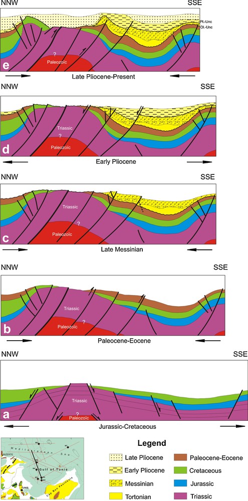
Kinematics and geodynamic evolution of the Gulf of Tunis through the NW–SE direction. This model shows the main tectonic deformations from the Jurassic rifting to the Pliocene contractional events.
Cinématique et évolution géodynamique du Golfe de Tunis suivant la direction NW–SE. Ce modèle montre les principales déformations tectoniques depuis le rifting jurassique jusqu’à la compression pliocène.
Since the ending of Cretaceous (Late Maastrichtian) and until the Middle-Upper Eocene, the NE-SW ancient accidents have still controlled the sedimentation in a compressional context (Ben Chelbi, 2007; Bouaziz et al., 2002; El Euch et al., 2004; Khomsi et al., 2006; Letouzey, 1986; Mzali and Zouari, 2006; Patriat et al., 2003; Zouaghi et al., 2005b). This compressive stress has generated the reverse movements along the NE-SW ancient accidents that delineated deformed sub-basins with major gaps and unconformities (Figs. 3, 4 and 6 b). Tilting of the sedimentary floor along the faulted zone is marked, in the W2 well by the avalanche breccias at the Late Eocene. In the Algeria domain, the Oligocene–Aquitanian deposits seal the Maastrichtian–Lutetian folded features in the Hodna Basin and the Aures Mountains (Bracène and Frizon de Lamotte, 2002).
The Priabonian and Oligocene deposits seal the structures resulting from the Eocene Pyrenean paroxysm. The Oligocene series are only identified in the W1 well, located at the south part of the study area, near the Cap Bon peninsula. Thus, we can confirm the extension of the NE-SW high zone, developed during the Oligocene, in the Gulf of Tunis (Figs. 3, 4 and 6 c). This “Bald” zone coincides, geographically with the domes and diapirs zones in the Tunisian Atlas (Fig. 1). This period corresponds to a relieving phase marked by a basic volcanism and installation of the subsiding trough faults in the European domain: Rhin, Limagnes and Rhone grabens, and the Paris, Marseille and Basse-Provence basins (Coulon, 1992; Coutelle and Duée, 1984). The generalized marine invasion of Middle Miocene is fossilized by onlapping of the Langhian limestones (Ain Grab formation) (Figs. 4–6). This transgression was also described in the Cap Bon peninsula (Bedir et al., 1996; Ben Salem, 1992; El Euch, 2008; Letouzey, 1986; Mannaï-Tayech, 2006) and in the Gulf of Hammamet (Patriat et al., 2003).
The Gulf of Tunis was affected during the Oligocene–Early Miocene by the NE-SW extensional processes. These intracontinental deformations are represented by major normal faults that bordered the tilted blocks, and by transverse structures. The seismic lines show a complex system characterized by a clearly asymmetric structure, with a successive polarity west-dipping half-grabens. Accompanying master faults, both antithetic and synthetic longitudinal normal faults are identified (Fig. 5). The schematic structural map shows the major normal fault trends. A major longitudinal NW-SE trend, parallel to the Pantellaria–Linosa rift axis (Fig. 1A), and separate the NE-SW transverse oblique trends, corresponding therefore to the transfer zones (Fig. 2). Structuring and kinematics of the asymmetric basins are controlled by these faults emphasising the change of polarity of the half-grabens (Figs. 2 and 5).
The Middle to Late Miocene is represented by a thick lagunal facies deposited in isolated and sometimes deltaic basins (Boujamaoui et al., 2000; Mannaï-Tayech, 2006). The lack of the Messinian deposits on the uplifts areas (Figs. 4 and 6 c) is due to a combination of vertical movement of border faults and a regional eustatic sea-level fall along the Mediterranean Basin. The witnesses of the NW-SE Alpine and Atlassic compressional phases, correspond to the installation of the NE-SW Tellian and Atlassic folds as well as the migration of the overthrust sheets towards the south-east (Melki, 1997; Rouvier, 1977). Moreover, the coexistence of the local extensions in a regional compressional stress was shown on the level of the grabens of Tunisia. Thus, the extension described in the Grombalia graben appears by N130-150 synsedimentary normal faults, which are subparallel either to the graben and the direction of a regional shortening (Chihi and Philip, 1998). The contemporaneous activity of normal and reverse faults with the thrust system suggest that the Siculo–Tunisian Strait may be being shaped by the occurrence of two independent tectonic processes that act simultaneously and overlap each other: the Maghrebides–Apennines accretionary prism and the Siculo–Tunisian Channel rift (Chihi and Philip, 1998; Corti et al., 2006). In addition, as it was announced by other authors (Casero, 2004; Casero and Roure, 1994; Catalano et al., 2000; Chihi and Philip, 1998; Faccenna et al., 2005) progressive migration of the subduction blockage from west to east has involved a structural zone represented by the graben structures. This domain of the atlaso-pelagian trough corresponds to a thinned continental crust at the level of the Siculo-Tunisian strait and forming the Pantellaria–Linosa recent rift.
Analysis of the seismic lines shows asymmetric half-graben structures during the Early Pliocene, indicating the extensional event. Deposits are considerably thick towards the subsiding edges and missed on the high folded structure (Figs. 4–6 d). Extension is more pronounced with an increase in subsidence and vertical throw of major graben-bounding faults proceeding southeastward. The Upper Pliocene strata overlie the other Lower Pliocene by aggradational and retrogradational deposits, showing the NW-SE reverse displacement. Inversion of the subsidence at the Late Miocene and the end of Early Pliocene periods is probably related to rejuvenation of the NE-SW and NW-SE faults (Figs. 4–6 e). For other authors, working in the north-eastern Tunisia onshore, the compressive stress was continued during the Pliocene–Quaternary intervals (Ben Ayed, 1993; Letouzey, 1986) and even in the Actual (Boutib et al., 1997; Dlala and Rebaï, 1994; Melki, 1997; Melki et al., 2001; Rekhiss, 2007). Locally, in the South of Italy, it is rather an extensive event that starts since Late Tortonian–Early Messinian (Pepe et al., 2005) and at the Late Pliocene, in the Crotone basin (Zecchin et al., 2004). These local extensions are located in a NW-SE regional transpressive stress.
5 Conclusions
The overall lithostratigraphy well data, outcrops, and seismic interpretation of the Mesozoic and Cenozoic deep structures of the Gulf of Tunis, led to the conclusion that sedimentary distribution of the alpine margin in the north-eastern Tunisia is controlled by inherited tectonic deformation associated with the Triassic rising and the eustatic fluctuations.
The NE-SW striking set, associated with folds and faults showing a reverse component, and the NW-SE striking set, delineate the subsiding grabens and synclines, characterize the current structural pattern. These basement faults, together with the local associated salt movements, divided the study area in separate folded uplifts and subsiding depressions (grabens, half-grabens and synclines). Tectonic deformations produced deep-bordered faults, which have caused the formation, the filling and the migration of the deep structures.
Variations of the thickness and the seismic facies from the basin-ward into the landward associated with erosional truncations and major unconformities, fossilized by the onlap/downlap and toplap terminations below and above the main seismic units, record the main synsedimentary tectonic events. During the Mesozoic periods, the North African margin was affected by extensional and transtensional movements, fossilized by synsedimentary normal faults that are associated with the graben and syncline structures. This kinematic caused thickening of depositions in the centre of basins and their onlapping on the flanks. In the Cenozoic, the northern Tunisia was deformed under compressional and transpressional episodes. Tectonic movements corresponded to the rejuvenation of inherited boundary faults. The block tilting and subsidence migration happened in accordance with successively compression/extension events, associated with the Triassic salt rising.
Using cross seismic sections, we try to reconstruct the Mesozoic and Cenozoic kinematics of the Gulf of Tunis offshore. Furthermore, comparing the main deformation events with the tectonic and sedimentary evolution of the adjacent areas allow us to attach it to the north African and western Mediterranean geodynamic scenarios.
Acknowledgments
The authors acknowledge the anonymous referees for detailed and constructive reviews. We wish to thank the ETAP petroleum society for providing petroleum wells data and reflection seismic lines.