

1 Introduction
The Central High Atlas and Middle Atlas Mountains of Morocco display high anticlinal ridges (about 4000 m and 3000 m above sea level, respectively) bounding wide synclinal plateaus. As a consequence, these mountain belts are relatively well watered, snow-covered in winter, and then rich in lakes. In particular, the Imilchil area in the heart of the central High Atlas (Fig. 1A) is famous for its twin lakes poetically named Lake Tislit and Lake Isli (Berber for “the bride” and “the bridegroom”, respectively). The deepest one, i.e. Lake Isli, has been the object of a detailed survey (morphology, hydrology, sedimentology, stable isotope study and 14C dating of the lacustrine deposits) as it offers a record of the evolution of the environmental conditions in the semi-arid mountainous domain of North-West Africa during the Pleistocene–Holocene (Lamb et al., 1994; Roberts et al., 2008; Zeroual, 1995).
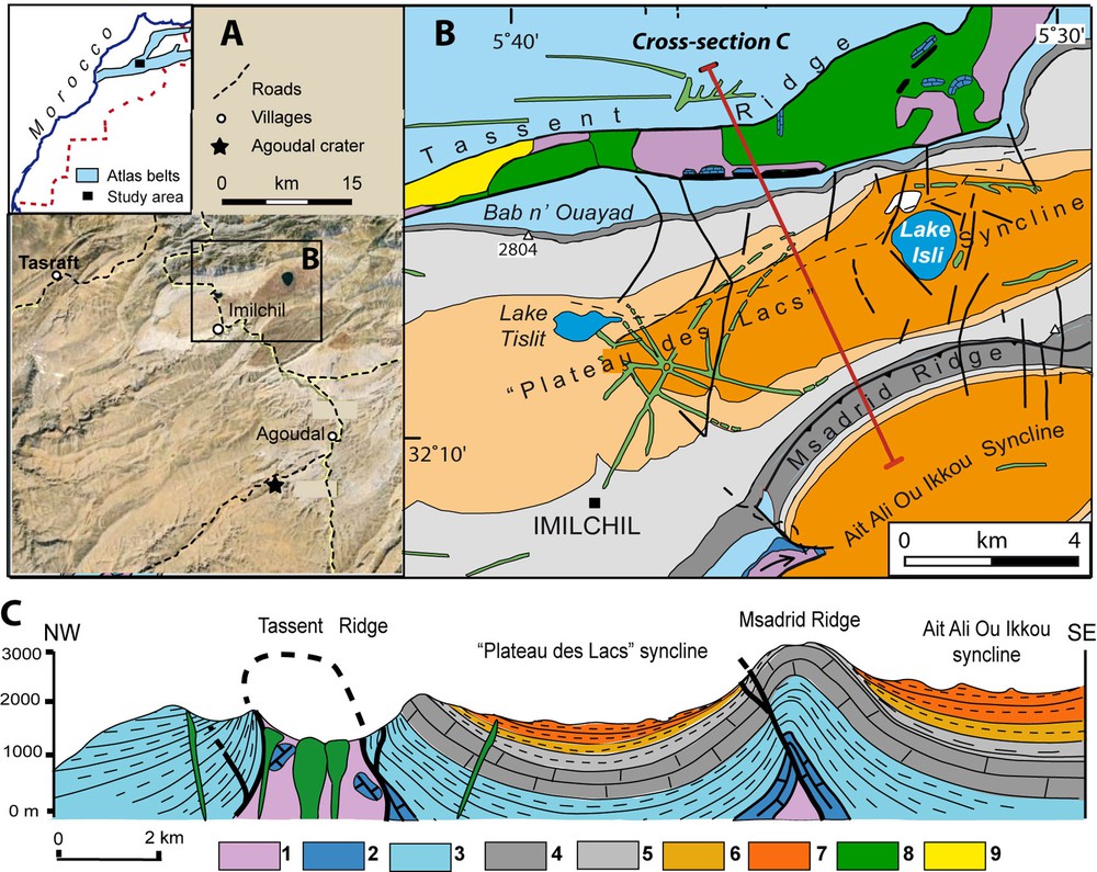
(Colour online.) A. Location map in central High Atlas; insert: Location in the Atlas system. B. Simplified geological map of the Imilchil area. C. Cross-section (see location in B). 1: Triassic basalts and argillites; 2: Lower Liassic limestones; 3: Ag1 or Tassent Formation (Fm.), Upper Liassic-Aalenian; 4: Ag2 or Bab n’Ouayad Fm. (“Calcaire Corniche”), Lower Bajocian; 5: Ag3 or Tislit Fm., Middle–Upper Bajocian; 6: An1 or Imilchil Fm., Lower Bathonian; 7: An2 or Isli Fm., Bathonian–?Callovian red beds; 8: Magmatic rocks, mainly gabbroic (Middle–Late Jurassic); 9: Thanetian–?Ypresian red beds and basalts (Tassent Ridge).
In year 2012, Moroccan newspapers echoed a sensational information divulgated by academic geoscientists: twin lakes Tislit and Isli would be an exceptional case of “dual impact craters”. A few months later (online June 2013), this surprising finding was published as a formal paper by Ibhi et al. (2013). This interpretation was received with great skepticism by the Moroccan geological community, and indeed was immediately denied by meteorite specialists (Chaabout et al., 2013). However, the first team again published in another journal and then in an international colloquium their impact crater interpretation, now restricted to the deepest lake (Lake Isli) of the Imilchil area (Nachit et al., 2013; Ibhi and Nachit, 2013). Lake Tislit was no more considered as an impact crater in these second and third publications, but Lake Isli was presented as linked to the Agoudal meteorite just described by Chennaoui-Aoujehane et al. (2013) and whose crater was localized by Sadilenko et al. (2013) 20 km further in the southeast of Lake Isli (Fig. 1A).
The aim of the present paper is primarily to present the geological data that support a progressive, tectonic–karstic formation of Lake Isli. As a complement to the abstract by Chaabout et al. (2013), we also discuss and discard the arguments presented by Ibhi et al. (2013), Ibhi and Nachit (2013) and Nachit et al. (2013) in favour of their catastrophic, impact crater interpretation.
2 Geological setting
The Atlas System (High Atlas and Middle Atlas) formed through inversion of former Triassic–Liassic rift basins during the Africa–Eurasia convergence (Frizon de Lamotte et al., 2008, with references therein). The post-Variscan sedimentation began with thick Triassic argillites and evaporites responsible for subsequent diapirism (Bouchouata et al., 1995; Ettaki et al., 2007; Michard et al., 2011; Saura et al., 2013). The Triassic deposits are topped with the widespread Central Atlantic Magmatic Province (CAMP) basalts (Youbi et al., 2003). In the central High Atlas, the marine succession (Fig. 2) on top of the CAMP basalts includes the following formations (Azizi Kadmiri, 1999; Fadile, 2003; Ibouh, 1995, 2004; Studer, 1987): Liassic shallow water limestones (ca. 300–400 m); Upper Liassic to Aalenian deep platform carbonates, marls and shales (Agoudim 1 = Tassent Fm., > 600 m); Lower Bajocian reefal limestones (“Calcaire corniche”, Agoudim 2 = Bab n’Ouayad Fm., > 200 m), and Middle–Upper Bajocian shallow water limestones and marls (Agoudim 3 = Tislit Fm., ca. 600 m). This 2000-m-thick marine sequence is followed upward by brackish deposits (Lower Bathonian Anemzi 1 = Imilchil Fm., ca. 200 m), then continental red beds (Upper Bathonian–?Callovian Anemzi 2 = Isli Fm., at least 250 m thick). The Triassic–Jurassic sequence was deformed progressively during the sedimentary evolution of the basin (Ibouh, 1995, 2004) due to diapirism (Michard et al., 2011; Saura et al., 2013). Alkaline-transitional gabbroic magmatism emplaced in the form of sills, dykes and outpours during the Latest Bathonian–Late Jurassic (Armando, 1999; Hailwood and Mitchell, 1971; Ibouh et al., 2002; Lhachmi et al., 2001; Zayane et al., 2002). Younger basalts also emplaced in the Barremian red beds by place in the Central High Atlas (Haddoumi et al., 2010). Marine sedimentation resumed during the Aptian, extending all over Morocco during the Cenomanian–Turonian high stand. In the Imilchil area, Cretaceous deposits are lacking due to erosion, as attested to by the unconformity sealed by Tanethian–?Ypresian red beds (Charrière et al., 2009, 2011; Michard et al., 2011). Superimposed folding events have been dated in the northern and southern SubAtlas Zones from the Late Eocene, Early Miocene and Pliocene–Quaternary (El Harfi et al., 2001; Frizon de Lamotte et al., 2000, 2008; Teson and Teixell, 2006). The present-day high elevation of Central High Atlas depends not only on the Late Eocene–Neogene crustal shortening, but also on the hot mantle anomaly developed under northern Morocco during the Neogene (Fullea et al., 2010; Missenard et al., 2006; Teixell et al., 2005).
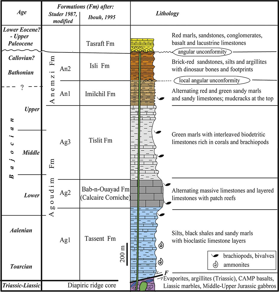
(Colour online.) Stratigraphic column of the formations exposed in the Imilchil area, after Charrière et al. (2011), modified. Middle–Upper alkaline-transitional magmatism is shown in the form of a stock in the core of the ridge and a dyke that reaches up to the Bathonian–?Callovian red beds.
3 Hydrogeology and structural setting of Lake Isli
The Imilchil lakes Tislit and Isli are localized in the “Plateau des lacs” syncline bounded by two anticlinal ridges, namely the Tassent Ridge in the North and Msadrid–Ait Ali-Ou Ikkou Ridge in the South (Figs. 1B, C). These ridges correspond to upright folds, longitudinally curved and cored by diapiric evaporites and gabbroic intrusions (Ibouh, 1995, 2004).
Lake Isli is a vertical, subcircular hollow in the nearly horizontal Middle Jurassic red beds of the “Plateau des lacs” syncline. Its surface is 2.55 km2, with a diameter close to 1200 m, and its depth is about 95 m (Lamb et al., 1994; Zeroual, 1995). The latter authors recognized all around the lake steep (up to 40%) underwater slopes and measured a 100-m thickness of soft sediments. Only the upper 25 m of these deposits are laminated lacustrine beds, whereas the lower infilling seems to be coarser colluvium. Minor centripetal normal faults and slumps can be observed in the soft sediments all around the lake, due to the slope steepness.
The present-day hydric balance of the lake is mainly due to inflow from the “Plateau des lacs” water table (Zeroual, 1995). Lake Isli is no longer drained by any superficial stream (contrary to previous occasions in the past), which suggests the occurrence of some subterraneous outflow. As the lake opens in the upper levels of the Isli Fm., the hard-rock bottom of its lacustrine–colluvial deposits is located at about the level of the Imilchil and/or Tislit formations. Part of the hypothetic subterraneous flow could occur laterally towards the deeply incised gullies in the north of the plateau (Fig. 3), as suggested by small springs in these gullies, but another part could percolate down to the “Calcaire corniche” and their karstic cavities. Chemical and isotopic studies (Roberts et al., 2008) reveal that Lake Isli waters are oversaturated in carbonates, consistent with their dominant origin from the water table of the “Plateau des lacs”.
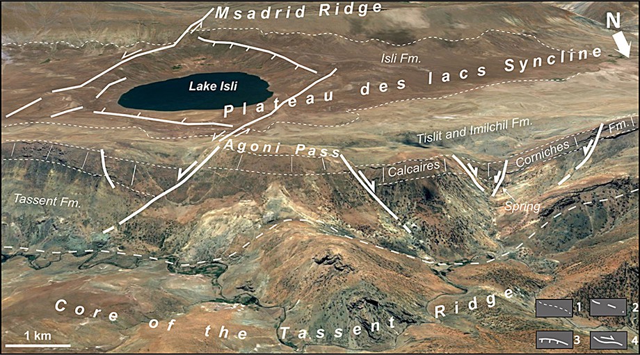
(Colour online.) Structural interpretation of Lake Isli area (tilted Google earth). 1: Stratigraphic limit; 2: Southern limit of the Tassent Ridge core; 3: Normal fault, 4: Strike-slip fault.
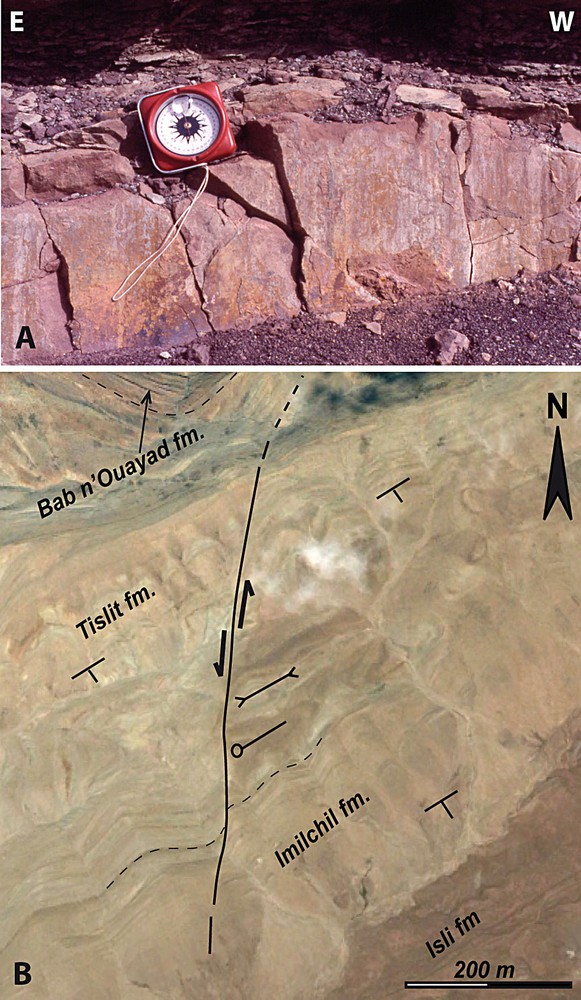
The “Plateau des lacs” syncline and the ridges are crosscut by a number of transverse faults (Fig. 1B). Examination of satellite imagery next to Lake Isli shows the occurrence of both ESE- and NNE-striking faults that feature a broadly lozenge fault array around the lake (Figs. 3 and 4). The ESE-striking faults are steep normal faults whose vertical throw does not exceed the thickness of the Isli Fm. (ca. 200 m). By place, down-dip striation can be observed on fault mirrors cutting through sandstone beds (Fig. 5A). The NNE-striking faults bound the ESE-striking ones west (Agoni Fault) and east (Isli Fault) of the lake. Faults with similar NNE strike are observed further in the east and west of the Isli and Agoni faults, respectively (Fig. 5B). These NNE-trending faults are nearly vertical, left-lateral faults (Figs. 5B and 6B). The Agoni fault crosscuts the southern flank of the Tassent Ridge with a sinistral throw of some hundred meters. The Isli Fault crosscuts the Msadrid Ridge in the south and does not reach the Tassent Ridge in the north. A minor, synthetic fault roughly parallels the Isli Fault in the west (Fig. 4A), which evokes a braided strike-slip fault setting. Altogether, these faults determine a lozenge-shaped basin typical for a small pull-apart basin in the core of which Lake Isli is located. The basin foundering is well documented by the sudden tilting of the otherwise horizontal Bathonian-?Callovian red beds inside the basin (Fig. 4). Bedding dips systematically toward the lake by ca. 30° (Fig. 6A, B), except in the northern side of the lake.
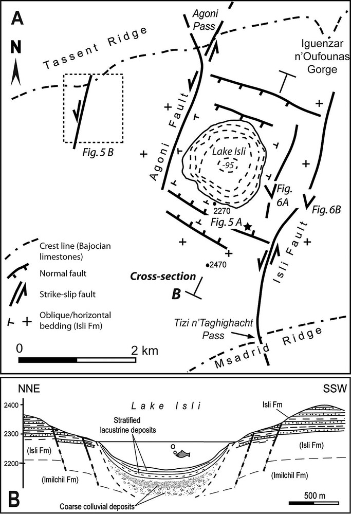
Structural map of Lake Isli area (A) and NNE–SSW cross-section of the lake (B). See Fig. 1 for location. Notice the lozenge-shaped fault pattern around the lake, and the dip of the Isli Fm. sedimentary beds converging toward the lake east, west and south of the lozenge. This pattern is that of a pull-apart basin.
(Colour online.) A. Fault mirror of a N110-striking normal fault in the south of Lake Isli (see Fig. 4A for location). Notice the steep dip and the clear down-dip striation. B. NNE-trending left-lateral fault about 2 km west of Lake Isli, as shown by satellite imagery. Google Earth image located in Fig. 4A. Notice the en-echelon fold hinges on the right side of the fault (opposite arrows: synclinal axis; circle and slightly curved line: anticlinal axis with eastward plunge).
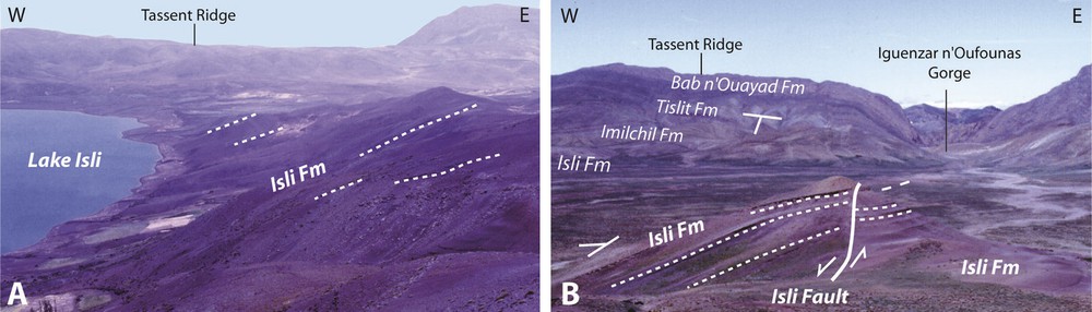
(Colour online.) 6A. View of the southeastern slope of Lake Isli depression showing the northwestward dip of bedding in the Bathonian–?Callovian Isli Fm. 6B. Directional view of Isli Fault crossing the “Plateau des lacs” syncline east of Lake Isli. Notice the sudden change of dip of the Isli Fm. red beds west of the fault.
4 Discussion
Lake Isli displays a rather remarkable morphology, with its subcircular contour and great depth. Therefore, questioning its origin is certainly reasonable. This question was briefly considered by Ibouh (1995) and Zeroual (1995). The first author discarded an impact crater hypothesis previously evoked and proposed a tectonic control without providing detailed mechanisms. Ibouh (1995) also favoured a tectonic origin in a north–south transtensional setting. In contrast, Ibhi et al. (2013), Ibhi and Nachit (2013) and Nachit et al. (2013) claim that Lake Isli at least is a 40-ka-old impact crater (in their first paper they included Lake Tislit in their catastrophic theory). Below, we firstly discuss the arguments presented in support of the impact crater theory. Second, we present a new tectonic–karstic interpretation of the formation of Lake Isli.
4.1 Irrelevance of the impact crater theory
According to Ibhi et al. (2013) and Nachit et al. (2013), an impact crater at Lake Isli would be documented by the occurrence of scattered meteorites, breccias, planar deformation features (PDFs) in quartz grains, radial fractures and centripetal dip of bedding. The authors specify that the meteorite impact would have occurred about 40 kyr ago. Let us examine these affirmations successively.
Fragments of ataxite rich in nickel have been found indeed around Tasraft, i.e. 15 km west of Lake Isli, and Agoudal, 20 km further to the southeast (Fig. 1A; Chennaoui-Aoujehane et al., 2013; Ibhi et al., 2013). It seems likely that an iron meteorite (formally named Agoudal meteorite; http://www.lpi.usra.edu/meteor/index.php) did scatter in the area at some recent Quaternary epoch. Sadilenko et al. (2013) localize the impact close to Agoudal and describe an east–west, 1.5 km long strewn field. In contrast, Nachit et al. (2013) consider a 38-km long, roughly north–south strewn field connecting Agoudal to Lake Isli. However, the observed dispersal does not offer any serious argument in support of an impact origin of Lake Isli.
The breccia samples presented by Ibhi et al. (2013) are strongly different from proved impact breccias such those of Haughton Crater (Frisch and Thorsteinsson, 1978). The sample shown by Ibhi et al. (2013) in their Fig. 4A is an Upper Bajocian sedimentary breccia including some rounded pebbles and cropping out north of the Msadrid Ridge, whereas the sample in their Fig. 4B is a typical sedimentary facies from the bottom of the Bathonian red beds.
Only rare planar deformation features (PDFs) in quartz grains were noticed by Ibhi et al. (2013). Taking into account the Anti-Atlas and/or Saharan origin of the Atlas Jurassic red beds in this area (Frizon de Lamotte et al., 2008; Studer, 1987), the grains with PDFs may be regarded as detrital grains originating either from low-grade metamorphic Cambrian sandstones of western Anti-Atlas shear zones (Belfoul et al., 2002; El Hasnaoui et al., 2011; Soulaimani et al., 1997) or from Pan-African mylonites (Bouillier and Bouchez, 1978). The lack of shocked quartz is noticed by Sadilenko et al. (2013) even at Agoudal.
The minor radial fractures (a few tens of centimetres long) presented by Ibhi et al. (2013) in their Fig. 4D are very usual in the sandstone beds at any distance of Lake Isli. They represent tectonic joints that form at the contact between two competent blocks compressed against one another. This has nothing to do with the hectometre or kilometre-scale radial fractures observed around the impact craters in association with concentric fractures (Frisch and Thorsteinsson, 1978). Such major sets of fractures can be observed neither in the field nor by automatic extraction of lineaments on satellite images around Lake Isli (El Alaoui-El Moujahid et al., 2012).
Likewise, Ibhi et al. (2013) notice the presence of centripetal dips in the Jurassic sediments around Lake Isli. They should be centrifugal if the lake were an impact crater (Bevan, 1998; Shoemaker, 1987). Shatter cones have been described close to Agoudal (Fig. 1A) by Sadilenko et al. (2013), followed by Ibhi and Nachit (2013) and Nachit et al. (2013). They would likely mark the emplacement of an eroded crater due to the main impact of the Agoudal meteorite. In contrast, shatter cones are apparently lacking, and at least not mentioned by Ibhi et al. (2013) around Lake Isli. Indeed, the varied lithologies do not show any particular modification in the Lake Isli area with respect to the adjoining areas of the “Plateau des lacs”.
Ibhi et al. (2013) and Nachit et al. (2013) estimate the age limit of the alleged impact crater of Lake Isli at 40,000 years, based on two arguments, (i) the occurrence of meteorite fragments in recent (“Soltanian”) Quaternary deposits, and (ii) “the age of the oldest sediments of Lake Isli, which had been dated to an age of 35,000 years (Zeroual, 1995)”. The first argument does not concern Lake Isli. Let us notice that Sadilenko et al. (2013) propose a younger age of ∼ 0.01 Myr for the Agoudal meteorite. The second argument of Ibhi et al. (2013) and Nachit et al. (2013) is biased. The oldest 14C age Lamb et al. (1994) and Zeroual (1995) obtained (34,850 ± 410 years) was measured at 65 cm from the top of a ca. 9-m long core emplaced on a deep submerged terrace of the southern slope of the lake. However, the total thickness of lacustrine sediments measured by Lamb et al. (1994) is more than 100 m. In other words, the bottom of the soft sediments infilling is by far older than 35 kyr. Even taking into account a significant decrease in the sedimentation rate from coarse colluvial deposits at bottom to stratified lacustrine beds on top, the onset of Lake Isli sedimentation could be in the range 200–400 ka (Middle Pleistocene), if not older.
4.2 Tectonic–karstic origin of Lake Isli
In Section 3, we showed that Lake Isli is located at the centre of a small pull-apart basin (Figs. 3 and 4). Extension in the relay zone of the Agoni and Isli sinistral strike-slip faults resulted in foundering of the sedimentary pile in between. This is clearly supported by the centripetal bedding dip observed around the lake (Figs. 4 and 6). The Agoni and Isli faults likely originated or were reactivated as tear faults during tightening of the Tassent and Msadrid diapiric ridges due to the main Neogene Atlas shortening (Beauchamp et al., 1999; Frizon de Lamotte et al., 2008; Teixell et al., 2003). If correct, the pull-apart basin could have developed during the Latest Pliocene–Early Pleistocene stages of shortening, consistent with the lack of Paleocene deposits inside. We may admit that the faults bounding the pull-apart basin crosscut the stratigraphic sequence down to the Lower Bajocian competent slab (“Calcaire corniche”) before being accommodated by more distributed, brittle-ductile structures in the thick, incompetent Tassent marls (Fig.7A).
In such a tectonic setting, karstic phenomena have been enhanced in the fractured Bajocian limestones, either in those of the Tislit Fm. (Middle–Upper Bajocian) or in the underlying “Calcaire corniche” (Fig.7B). We noticed above (Section 3) that part of the Lake Isli water outflow probably pass through karst cavities developed in these limestones. Such karst cavities are well known in the Imilchil area, for example at Ait Ali-Ou-Daoud, 20 km southeast of the lake (Mouguina et al., 2011), where they occur in the Tislit Fm. We may suspect that during the long-lasting evolution of the pull-apart basin, the largest karstic caves collapsed and allowed the deep lake to form in the already depressed topography.
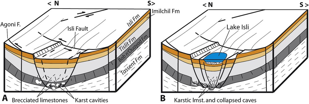
Cartoon showing the tectonic–karstic formation of Lake Isli. 7A (Pliocene?). Foundering of a small pull-apart basin during the latest stages of shortening of the adjacent ridges. 7B (Middle Pleistocene?). Collapse of the center of the pull-apart basin due to karstic caves collapses at depth, mainly in the Bab n’Ouayad limestones.
Indeed, Lake Isli is far to be an exception in the Atlas Mountains. About two tens of natural lakes scattered in the Middle and High Atlas also originate from similar tectonic–karstic phenomena (Baali, 1998; Benkaddour, 1993; Détriché et al., 2013; Hinaje and Ait Brahim, 2002; Rhoujjati et al., 2010, 2012). In every case, a sinkhole (“doline”) first appears in a synclinal plateau, either related to pull-apart faulting or migration of the underlying Triassic evaporites toward the adjacent ridges or both. Then, the Jurassic carbonate slab collapses due to karst development and a lake forms when the hydrologic conditions are fulfilled. The development of these tectonic–karstic lakes can be correlated with that of thick laminated travertines known on both sides of the Atlas Mountains. In particular, in the south fringe of the High Atlas, a laminated travertine yielded paleomagnetic and Th230–U234ages between 900–300 ka (Boudad et al., 2003; Weisrock et al., 2008).
5 Conclusions
- • In line with Chaabout et al. (2013), we definitely reject the identification of Lake Isli with an impact crater. The arguments repeatedly presented by Ibhi et al. (2013), Ibhi and Nachit (2013) and Nachit et al. (2013) in support of a 40-ka-old impact crater are not receivable.
- • Lake Isli, in spite of its inspiring morphology, must be reintegrated in the family of the tectonic–karstic lakes of the Atlas Mountains, mainly developed during the Middle–Late Pleistocene. Its progressive development has nothing to do with a catastrophic meteorite impact.
Acknowledgments
We are greatly indebted to both our Reviewers C. Hoepffner and D. Frizon de Lamotte for their constructive criticism of the early draft of this paper. We also acknowledge useful editorial comments by I. Manighetti.