

1 Introduction
Understanding how rocky coasts evolve through time needs to better study cliff recession and associated shore platform evolution. It is generally assumed that retreat rates of rocky coast cliffs and downwearing rates of shore platforms are dynamically linked (e.g., Moses and Robinson, 2011; Stephenson, 2000, 2008; Sunamura, 1992; Trenhaile, 2000, 2002; Walkden and Dickson, 2008).
Short-term rock cliff recession may be measured on multi-decadal timescales using aerial photographs, photogrammetry, airborne LiDAR or laser scanning comparisons, where mean erosion rates may be detected. Along the eastern English Channel, average erosion rates of chalk cliffs are of the order of several dm/year (e.g., Costa et al., 2004, Dornbusch et al., 2006; Moses and Robinson, 2011). At this timescale, the rate of surface lowering of shore platforms can be measured using micro-erosion meters (MEM) or traversing micro-erosion meter (TMEM) (e.g., Stephenson et al., 2010). In the eastern English Channel, shore platform downwearing and step backwearing erosion rates are of the order of a few mm/year (e.g., Moses and Robinson, 2011). Though direct measurements of erosion cannot be performed on multi-millennial timescales, cosmogenic radionucleides (Be10) have been used successfully in Normandy to date potential paleo-coastline location and to model cliff recession (Regard et al., 2012).
Estimating erosion rates of crystalline rocky coasts is more problematical at multi-decadal timescales due to very low erosion rates (Kennedy et al., 2014). In these cases, coastline evolution needs thus to be documented on time-periods larger than decades (i.e. centuries, Holocene and Neogene scale).
In passive margin contexts, paleo-coastline morphologies may be preserved in the subtidal part of the shore platforms, providing evidence of multiple sea-level fluctuations, tectonic adjustments, isostatic changes and rock resistance to weathering and marine processes. As a first step, paleo-coastlines need to be precisely defined and analyzed using high-precision morpho-bathymetry with regard to the geological context. A second step involves dating of the rock-denudation process in order to quantify coastline evolution during the Holocene and the Neogene. Taking into account the fact that long-term cliff recession is not systematically equivalent to the width of the shore platform (e.g., Moses, 2014; Stephenson, 2008), detailed studies on global environmental conditions (tectonic control, eustatic and isostatic changes) and local marine and weathering conditions need to be conducted on each studied site.
The aim of the paper is to provide an original morphostructural picture of the land-sea transition of rocky shores, including onshore coastal cliffs, beaches, intertidal and subtidal parts of shore platforms. A comparative analysis of two contrasted French coastal sites with rocky shore platforms is proposed. We present new high-precision merged land-sea digital elevation models (DEM) of two distinct types of rocky coasts along the eastern English Channel (Picardy and Upper Normandy: PUN) and in a NE Atlantic area (SW Brittany: SWB) in NW France. The PUN linear coast exhibits 40–90-m-high and poorly fractured vertical chalk (soft rocks) cliffs (Mesnil-Val), whilst the SWB low-elevation coast consists of highly fractured basement granite (Penmarc’h) (Fig. 1). The onshore–offshore coastal DEMs reveal specific multiscale morpho-bathymetric structures interpreted as paleo-coastlines. The combined analysis of onshore and offshore paleo-coastline markers represents a first step to evaluate modalities of long-term rocky coastline evolution during Holocene and Neogene, in close relation with shore platform morphology, lithology, and the geological context.
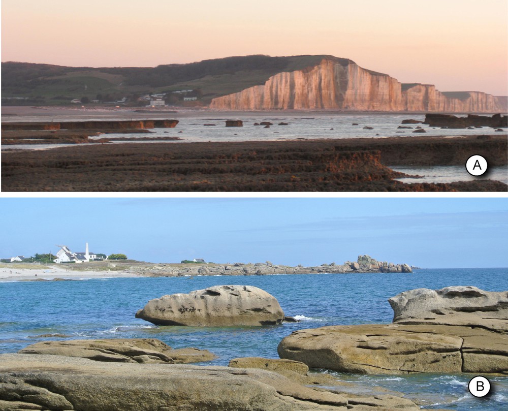
A. Mesnil-Val coastal site (PUN coast), view to the south, with vertical chalk cliffs, up to ∼90 m high, and its shore platform (Murons rocks, in the foreground). B. Loctudy site (SWB coast), view to the east, low-elevation granitic coast and its shore platform.
2 Data and methods
2.1 Airborne LiDAR data
PUN and SWB coasts were surveyed using airborne topographic LiDAR (RGEAlti®, IGN in 2011 and Litto3D® IGN/SHOM in 2012 respectively). We selected RGEAlti® LiDAR data south of Le Treport on a coastal surface 4 km long and 1.5 km wide (PUN coast), and Litto3D® LiDAR data along the southern coast of the Pays Bigouden peninsula (SWB coast), on a surface of about 130 km2, with a length of 25 km from Penmarc’h headland (west) to Bénodet (east) and a width of about 5 km inland. DEMs built inland present a vertical accuracy of 20 cm and a 1-m spatial resolution (Fig. 2).
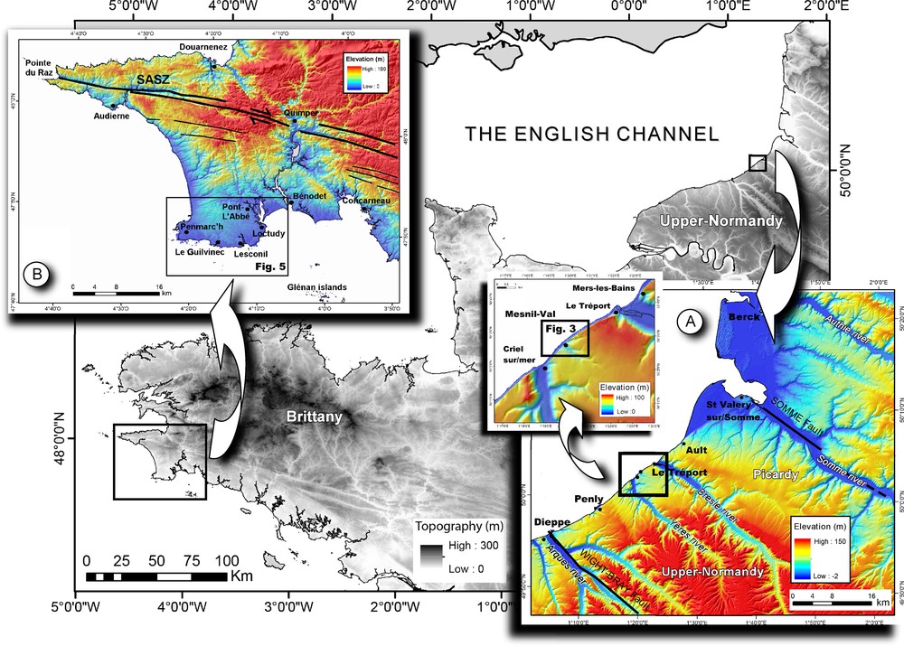
Location of study sites in NW France. Black and white NW France DEM is based on BDtopo250 (IGN). Colored DEMs are based on BDtopo25 data (IGN) from coastal areas in PUN and SWB. Topographic data were treated using ArcGis software. Studied sites are shown by black squares. SASZ: South Armorican Shear Zone. See explanations in the text.
Along the SWB coast, a subtidal coastal bathymetry was partly acquired in 2012 using bathymetric airborne LiDAR (performed by IFREMER) in water depths varying from 0 m to 10–20 m, on a surface of about 80 km2 covering the subtidal part of Penmarc’h platform (from Saint-Guénolé to Loctudy) and the Bay of Bénodet (from Loctudy to Bénodet). Submarine LiDAR DEM presents a vertical accuracy of 50 cm and a spatial resolution of 2 m.
2.2 GeoSwath Haliotis
In order to accurately image the subtidal part of the studied shore platforms, high-resolution shallow-water bathymetric data have been acquired using the R/V Haliotis (IFREMER) during the CROCOLIT 1, 2 and 3 surveys in 2013. We used GeoSwath interferometric sonar (from GeoAcoustics), which allows the acquisition of bathymetric data in very shallow water depths ranging from 5 m to about 100 m, with high vertical resolution varying from 20 cm for very shallow water depths to about 1 m for deeper water depths. Vessel navigation was achieved by RTK GPS (Real Time Kinematic Global Positioning System) using a reference station located at a distance less of 10 km on the coast, providing a positioning accuracy of a few centimeters. Sound velocity profiles were repeated daily in the vicinity to correct refraction errors. GeoSwath soundings were treated using CARAIBES software (©IFREMER) to clean and correct data from tide variations using correlations between SHOM hydrographic bathymetric reference, IGN land terrestrial altimetric reference (RGF69) and the daily recorded tide curve. The combination of water-depth and cruise data provides a 1-m grid DEM, edited with ArcMap GIS software.
On the PUN coast, we chose to map continuously the subtidal shore platform offshore Mesnil-Val town. The shallow-water bathymetry GeoSwath data (CROCOLIT cruise, legs 1–3) were acquired on a 2-km2 box, from a distance of about 200 m from the cliff face to about 1 km offshore. The high part of the tidal flat is covered with airborne topographic LiDAR, whereas the lower part is mapped using GeoSwath (Fig. 2a and Fig. 3).
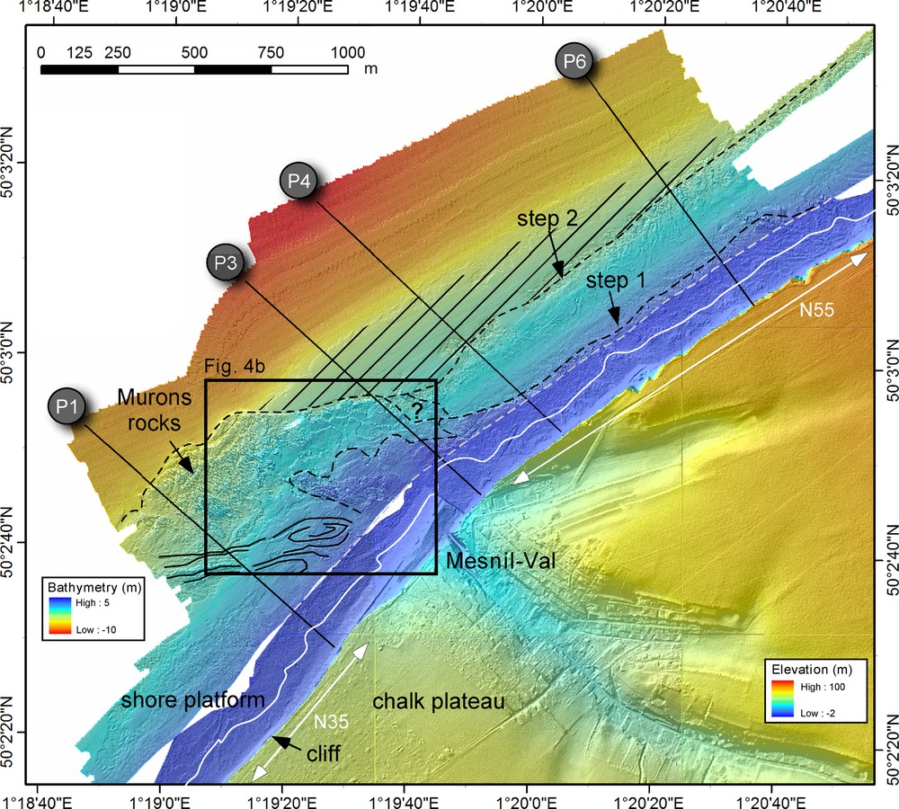
Merged Land-Sea DEM with a compilation of onshore data based on the RGEAlti 76 (topographic Lidar data) (IGN) and offshore GeoSwath bathymetry acquired during the CROCOLIT cruise. Color scales are inverted between the offshore and the onshore part of the DEM. Dashed grey line marks the limit between aerial LiDAR and GeoSwath data. Continuous white line corresponds to terrestrial zero RGF69 (IGN). P1, P3, P4, P6 lines are bathymetric profiles. White arrows indicate coast orientation. Curved dashed lines correspond to steps 1 and 2 reported on the shore platform. The hatched area corresponds to a subtidal sedimentary ridge (Fig. 4). Black lines underline a fold structure axis on the shore platform. Fracture azimuths (160 data) measured on the shore platform near Mesnil-Val are reported.
On the SWB coast, we chose to complete offshore bathymetry LiDAR DEM (acquired by IFREMER) to image the edge of the shore platform. Shallow-bathymetry performed during CROCOLIT cruise (leg 2) was acquired from 10 m to 60 m water depths, between Saint-Guénolé and Loctudy (Penmarc’h shore platform) on a surface of about 40 km2. Where bathymetric LiDAR and GeoSwath data overlapped, GeoSwath data have been preferred because of their higher precision (Fig. 2b).
GeoSwath and LiDAR data merging was performed using ArcMap GIS software to produce a single onshore/offshore elevation surface with a 1-m spatial resolution, and using the same altimetric reference. An ArcMap hillshade layer was superposed to the Land-Sea DEM to better visualize 3D relief. As French hydrographic data differ from the terrestrial altimetric reference (RGF69), GeoSwath data were vertically corrected according to the hydrographic corrections used in the nearest harbors (–4.517 m at Le Tréport (PUN) and –2.537 m at Le Guilvinec (SWB)). Merged DEMs are based on the terrestrial altimetric reference (RGF39).
3 Upper-Normandy (PUN) coastline at Mesnil-Val
3.1 Mesnil-Val onshore characteristics
The linear rocky coast at Mesnil-Val cuts through a roughly horizontally-bedded succession of Upper Cretaceous Chalk, with large-scale (∼10-km wavelength) folding and brittle structures (Duperret et al., 2012). The Lewes Nodular Chalk Formation, Upper Turonian to Lower Coniacian in age, exposed between Le Tréport and Criel-sur-Mer (Duperret et al., 2012; Senfaute et al., 2009), contains soft, marly bands and nodular hardgrounds, with regular flint layers (Bristow et al., 1997; Mortimore and Pomerol, 1987).
Between Le Tréport and Criel-sur-Mer, strata are slightly inclined in the northern flank of the NW–SE-oriented Criel-sur-Mer syncline, limited to the north by the Eu extensional fault and by the Penly anticline to the south (Mortimore, 2011) (Fig. 2a). Many of the marls and flints strata flatten and coalesce in the syncline hinge between Mesnil-Val and Criel-sur-Mer (Mortimore and Pomerol, 1987). Here, the cliff profile strictly mimics the strata dip variations. Inland, the chalk plateau altitude decreases progressively from 100 m at Le Tréport to 30 m at Mesnil-Val, with a regular N55-oriented coastal cliff; by contrast, the Mesnil-Val to Criel-sur-Mer cliff section presents a constant altitude (50 m), and a N35° trend (Fig. 2a and Fig. 3).
3.2 Mesnil-Val shore platform morphology
The low sloping shore platform configuration is related to “type A”, as defined by Sunamura (1992). The shore platform develops in a macrotidal context, with a 10-m astronomic tidal range. The intertidal shore platform (observable at low tide) extends from a distance of 200 m to 600 m seaward, with an average slope of 0.7°. The subtidal part, as imaged by CROCOLIT data (Fig. 3), shows a mostly bare rocky shore platform between Mesnil-Val and Criel-sur-Mer (called Murons rocks plateau), extending over a distance of about 800 m from the cliff and ending with a 2-m-high step, located at –7.5 m NGF (steps 2′ on Fig. 4). A network of N110°-oriented runnels is observed on the Murons rocks plateau. Further northeast, the shore platform width decreases to extend on a distance of about 450 m from the cliff and is limited offshore by a continuous step (step 2), parallel to the coastline (Fig. 3). Here, no runnels are reported.
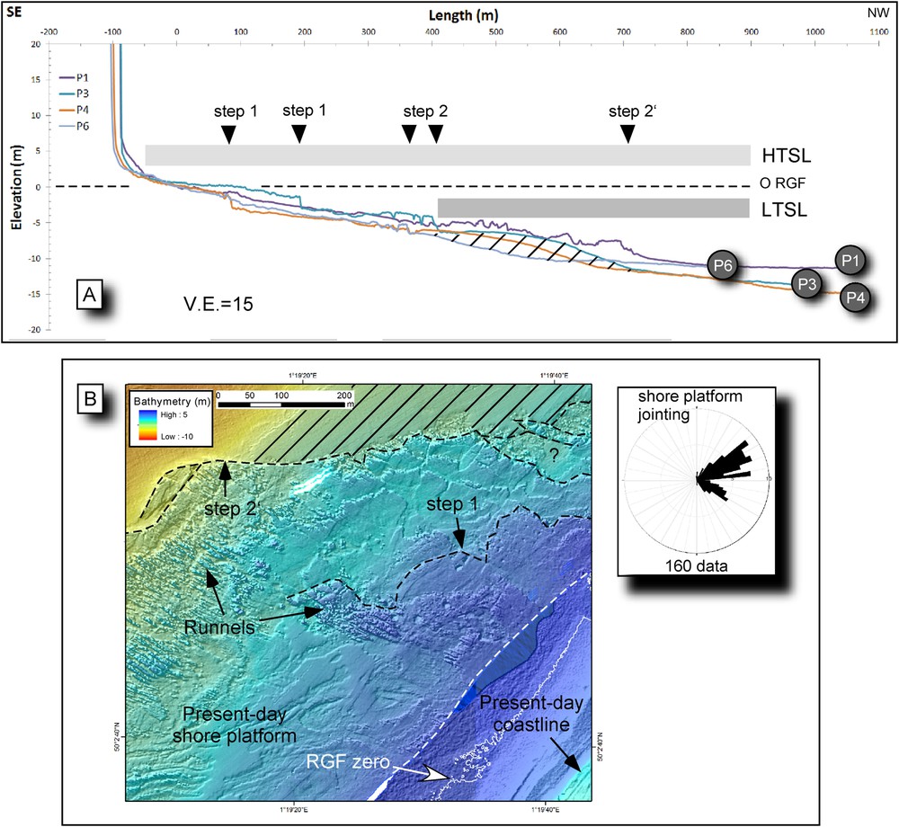
A. One-meter resolution bathymetric sections established from CROCOLIT cruise data, offshore Mesnil-Val. P1, P3, P4 and P6 profiles are located on Fig. 3. LTSL (mean Low Tide Sea Level) is defined between the Lowest Astronomical Tide Level (LATL) located at–4.507 NGF and the neap low-tide level at –1.967 m. HTSL (mean High Tide Sea Level) is defined between the Highest Astronomical Tide Level at 5.793 m and the neap high tide at 2.983 m. RGF is the French terrestrial altimetric reference. V.E. is vertical exaggeration. The hatched area corresponds to sand ridge accumulation against the shore platform step 2. Rough bathymetry corresponds to the bare chalky shore platform, whereas smooth bathymetry evidences sedimentary deposits on the distal part of the shore platform. B. Detailed DEM of the Murons rocks plateau evidencing runnels and subtidal steps 1 and 2. See Fig. 3 caption. Fracture azimuths (160 data) measured on the shore platform near Mesnil-Val are reported.
Several stacked bathymetric sections, produced from the subtidal GeoSwath data and intertidal LiDAR data (1 m resolution), run oblique to the coast (Fig. 4a) and display specific shore platform morphologies. A mean low-tide sea level (LTSL) is defined between the Lowest Astronomical Tide Level (LATL), located at –4.507 NGF and the neap low-tide level at –1.967 m (Fig. 4a). LTSL marks the limit between an upward smooth foreshore and a downward rough shore platform, as observed along profile 1 on the Murons rocks plateau.
As observed on profiles P1, P3, P4 and P6, a first 1–2 m-high low-tide step (step 1) is present on the foreshore at a distance ranging between 170 to 400 m from the cliff face. Steps develop continuously on low foreshore just below the LTSL (Fig. 4), as already reported (Augris et al., 2004; Hénaff et al., 2006). Low foreshore steps may be generated by step backwearing erosion (Dornbusch and Robinson, 2011; Regard et al., 2013) at the contact between LTSL and the chalk platform. According to Nesteroff and Mélières (1967), the low-tide step is the result of differential bioerosion processes between the zone with polydora and the zone with borers. Hénaff et al. (2006) suggested that low-tide steps correspond to the distal part of a collapsed mass, where pebble and shingle accumulation favor shore platform abrasion under the influence of the tide. On Mesnil-Val site, cliff collapse debris occurring as far as 200 m from the cliff are evidenced from the orthophoto analysis of the intertidal shore platform (Regard et al., 2013).
Another process needs thus to be mentioned to explain low-tide step formation 400 m away from the cliff. Low foreshore steps do not appear in areas where the chalk strata are deformed by N70°-trending folds and where the marine erosive process might have been disturbed (Fig. 3 and Fig. 4b).
From shallow-water bathymetric data, a second subtidal step (no 2) is seen to develop 2–3 m below the first one along P3, P4 and P6 profiles, under the lowest sea-level, and at a maximum distance of 500 m from the cliff face. On P3 and P4 profiles, two superposed steps appear, 200 m and 500 m away from the cliff face. Subtidal steps (2 and 2′) are located 2–3 m below low-tide steps (1).
The Murons rocks plateau (profile P1) develops in the flat hinge of the Criel-sur-Mer syncline, where the Lewes Chalk Formation encloses hard-grounds and marl condensed levels, the hardness of which is higher than those of the surrounding chalk. The distal part of Murons rocks plateau shows a bare chalky surface with shore-normal trending runnels, before ending seaward with a 2-m-high subtidal step (step 2′) (from –8 to –10 m), located below the present-day LTSL and morphologically linked to the subtidal step 2 (Fig. 4b). Northeast of Murons rocks plateau, a continuous subtidal ridge develops on P3, P4, P5, P6 profiles and abuts against the subtidal step 2. CROCOLIT high-resolution seismic profiles have evidenced modern sediments covering the chalk platform, with a progressively decreasing thickness landward. More or less muddy sands have been previously sampled in this area (Augris et al., 2004).
3.3 Origin of subtidal steps at Mesnil-Val
One major contribution of the Land-Sea DEM is to reveal that steps 1 and 2 are continuous and oriented N55°, i.e. parallel to the present-day coastline (Fig. 3). Fracture measurements on the rocky foreshore (160 azimuths over 0.14 km2) have shown two patterns of discontinuous joints, trending respectively at N50–70° and N120° (Fig. 4b). The first one likely controlled the N55° strike of the 2-km-long coastline between Mesnil-Val and Le Tréport. Steps are located near the present-day LTSL and may be eroded by step backwearing during low-tide sea levels, as already suggested on this coast type (Dornbusch and Robinson, 2011; Hénaff et al., 2006; Regard et al., 2013). It is therefore likely that the intertidal and subtidal steps might have been guided at a local scale by the two above-mentioned joint networks. It is also suggested that small-scale lithological changes in the chalk rocks deeply control wave attack efficiency.
The Murons rocks plateau, limited seaward by step 2’, is chiefly made of nodular chalk, and marls, with firmgrounds and hardgrounds (Dewez et al., 2015), which are mechanically stronger than chalk that host step 2 further northeast. The distance between actual coastline and subtidal steps is closely related to the mechanical strength of chalky rocks. It is larger for hard rocks (step 2’ on Murons rocks plateau) than for soft rocks (step 2 between Mesnil-Val and Le Tréport).
4 South West Britany (SWB) coastline at Penmarc’h
4.1 Penmarc’h geology
Bounded to the south by the SWB coast in South Finistère, the Penmarc’h peninsula is part of the South Armorican Domain (SAD) in Britany. The SAD is primarily composed of granitic and high-pressure metamorphic rocks (schists and gneisses), ranging in age from 360 to 300 Ma and outcropping over a ∼30-km-wide zone, limited to the north by the N100°-trending South Armorican dextral shear zone (SASZ) (Jégouzo, 1980) (Fig. 2b, Fig. 5). The southernmost part of the SAD is a topographically depressed peninsula, referred to as the Pays Bigouden. Its substratum is made of the Pont-l’Abbé Hercynian granite that culminates at 30 m elevation in its central part (Fig. 5). The SWB coasts cut through these Hercynian crystalline rocks which were later locally disrupted by Meso-Cenozoic fault/fracture networks. The east–west-trending Penmarc’h headland is a scalloped granitic coast of very low altitudes (between 2 m and 10 m), with local granitic tors and boulder fields. Sandy foreshores usually connect the coast to the granitic shore platform, along small-scale coastal bays.
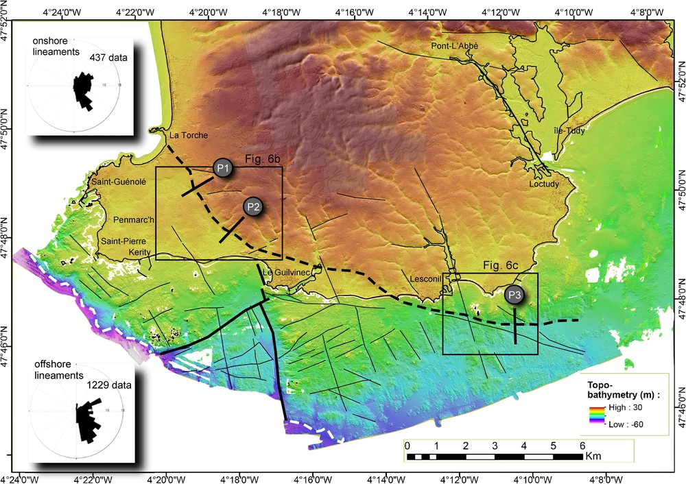
Merged land-sea DEM of the Penmarc’h peninsula. Onshore topographic data: compilation of BDAlti25 (IGN) and RGEAlti CG29 IGN (Litto3D project). Offshore data: compilation of bathymetric Lidar (IFREMER/SHOM) and GeoSwath data (R/V Haliotis) from the CROCOLIT cruise-Leg 2. The coast is indicated using black line (TCH). White line: terrestrial zero (RGF). The topo-bathymetry color scale is continuous from 30 m inland to –60 m offshore. Black lines: main lineaments reported from the DEM analysis. Thick black lines: major lineaments interpreted as faults. Thick dashed black line: cliff base relief (paleo-coastline). Thick dashed white lines mark the seaward limit of the shore platform. Lineament azimuths, deduced from a 1:20,000 DEM analysis, are reported on stereograms (437 onshore data and 1229 offshore data).
4.2 Penmarc’h onshore–offshore morpho-bathymetry
The shore platform develops in a mesotidal context, with a mean tidal range of 4.20 m during spring tides. The subtidal part of the shore platform comprises a large platform extending, in water depths less than 10 m, over a distance varying from 1.5 km off the Penmarc’h headland to 5 km off Le Guilvinec. To the southwest, the shore platform is bounded by a 40-m-high seaward-facing scarp (Fig. 5). The morphology of the Penmarc’h shore platform is that of a type-B platform (Sunamura, 1992), characterized by a mean slope of about 0.2°, with numerous subtidal steps. The smooth and flat morphology of the onshore peninsula strongly differs from the highly fractured and sharp morpho-bathymetry of the offshore platform. Offshore lineaments identified at the 1:20 000 scale are twice more abundant than those documented onshore (Fig. 5). DEM lineament analysis reveals a composite onshore/offshore system, composed of a main network trending at N150–170° and a secondary one oriented N60–70°. An additional N120–130° fracture system is documented offshore on the western part of the submarine platform, parallel to the general orientation of the platform edge (Fig. 5). The granitic shore platform is truncated by numerous incisions. Those trending N150–170° are deep submarine corridors partly filled up with sand ridges. Some of the small-scale lineaments produce 2–10-m-high subtidal steps (Fig. 5). One major structural feature evidenced on the land-sea DEM is the obliquity between the present-day east–west coastline orientation and the N120–130° trend of the seaward edge platform (Fig. 5). However, a continuous and 10-m-high onshore scarp, trending N150–170° between Le Guilvinec and La Torche, appears to be connected to a N120–130°-oriented lineament between Le Guilvinec and the coast, before extending further southeast offshore. This relief is believed to correspond to a paleo-coastline cliff with a regular slope gradient of 2.8°. It shows a smooth eroded morphology onshore, whilst being sharper offshore (Fig. 6). The paleo-coastline location appears to be guided onshore by a N150–170° fracture system, whereas its N90–100° offshore trace likely follows a SASZ-type fabric. Onshore, the flat western part of the Bigouden peninsula extends laterally over 4 km from the Penmarc’h headland (present-day coastline) to the smooth 10 m-high cliff inland. It probably represents a first-order paleo-shore platform, now aerially exposed. The eastern and western parts of the Penmarc’h shore platform resemble tilted blocks, with an apparent shift of 5-6 m high, along a N150-170° submarine lineament. Vertical shift might result from either uplift of the western part of the shore platform, or differential subsidence of the whole platform to the east. Large-scale tectonic processes have contributed to a progressive submersion of the paleo-coastline to the east.
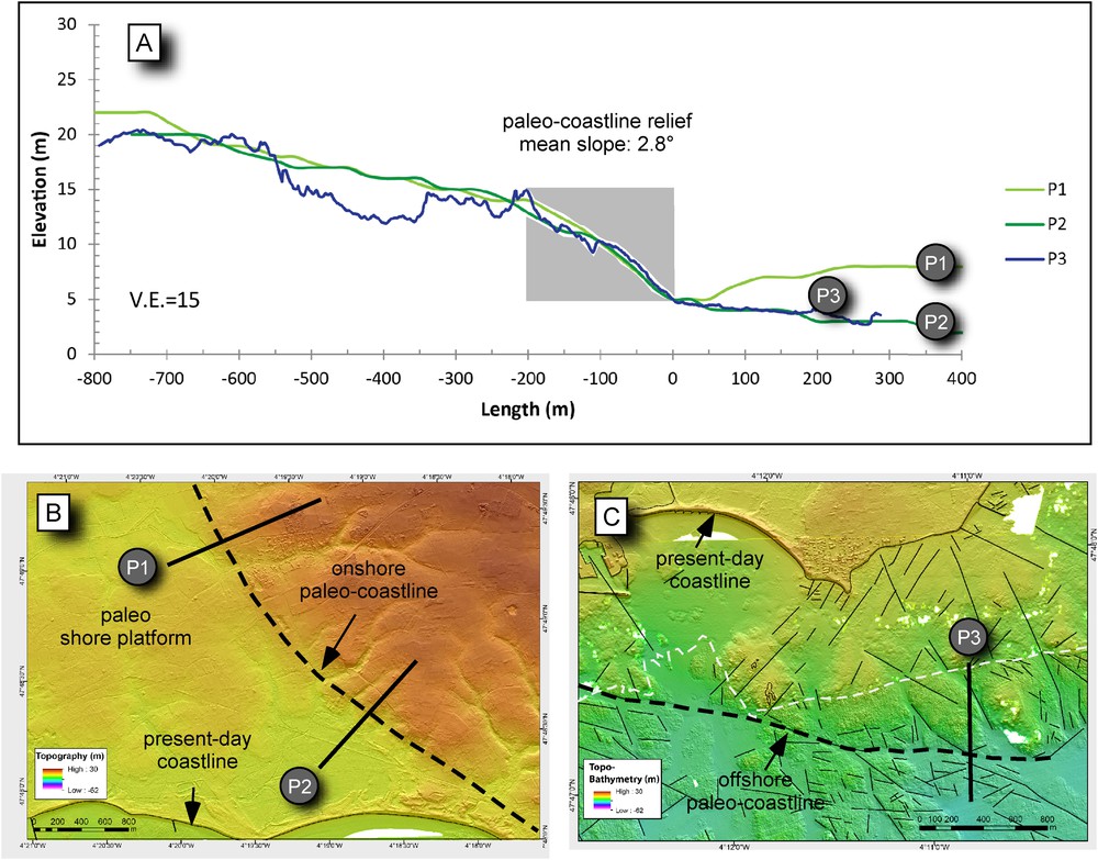
A. Superposed topographic (P1 and P2) and bathymetric (P3) sections perpendicular to the continuous inland and offshore paleo-coastline cliff. Elevations are fitted at the paleo-coastline cliff base, where the mean sea level is assumed to have occurred during the period of relief formation. Mean slopes of paleo-coastline reliefs are established on a 200-m-long (X) and 10-m-high (Y) area in grey. They show similar slope gradients with P1 = 2.5°, P2 = 2.6°, P3 = 3.3°. Sections are localized in (B) and (C). Note the smooth relief on P1 and P2 topographic profiles and the sharp relief on the bathymetric profile P3, as evidenced on the detailed DEMs onshore (B) and offshore (C). Black lines are tectonic lineaments reported at the 1:20 000 scale. The thick dashed black line represents the paleo-coastline trace. B. DEM based on aerial LiDAR records. C. White dashed line is the boundary between bathymetric LiDAR data (north) and GeoSwath data from the CROCOLIT cruise (south). See Fig. 5 for the location.
5 Discussion
5.1 Coastal erosion processes at Mesnil-Val
Along the PUN chalk coast (English Channel), a number of linear submarine morphological step-like features are evidenced on the rocky shore platform, parallel to the present-day coastline. Correlations between submarine step location, the present-day cliff base (coastline) and modern cliff recession rates permit an assessment of whether cliff recession is a constant process through a long time-period.
High coastal retreat rates, related to recurrent cliff collapses, have already been quantified elsewhere at:
- • 15 cm/year from 30-year cliff head comparisons (Costa et al., 2004);
- • 18 cm/year from cliff face TLS surveys over 2.5 years (Dewez et al., 2013);
- • 11–13 cm/year as averaged over several millennia (3000 years) with 10Be concentration profiles (Regard et al., 2012).
Shore platform lowering was estimated at 0.8 mm during the harsh 2008–2009 winter (Dewez et al., 2015). In Normandy, mean chalky shore platform lowering is estimated at 3.2 mm/year (Moses and Robinson, 2011), based on MEM (Foote et al., 2006) and laser (Swantesson et al., 2006) measurements.
Taking into account a cliff retreat rate of 11–18 cm/year over the last 3000 years (Regard et al., 2012) and considering no backwearing of the shore platform edge, the first low-tide step (step 1), located at a distance of 50–200 m from the cliff face, is likely to have developed 300 to 1800 years ago. A minimum age estimate for the initiation of the second morphological step (step 2), located about 500 m from the cliff face, is between 2800 and 4500 years. On the Murons rocks plateau, the 2-m-high submarine step extends about 800 m from the cliff face (step 2’), and it might have initiated in the time-range between 4400 and 7200 years.
As Holocene highstand sea-level stabilized between 7000 and 5000 years (Lambeck, 1997), it seems possible to create the Murons rocks plateau during the Late Holocene when applying a similar cliff retreat rate.
The seaward end of the Murons rocks plateau, marked by step 2’, is a likely candidate to be an inherited glacial period cliff. If we consider that cliff recession is only active during highstand sea-levels, the submarine inherited cliff (step 2’) was a continental cliff relief during the last glacial period, and was previously active during the last interglacial (MIS 5e). Subtidal steps may mark the Last Interglacial MIS 5e paleo-coastline location, initially with high cliff height that progressively degrades during glacial period (MIS 2) under periglacial climate and continental conditions. The following highstand sea level (Holocene) removed collapsed debris and submerged the paleo-coastline. As underlined by Moses (2014), the active present-day cliff recession (a few dm/year) observed along the chalky coast of the eastern English Channel could potentially form a contemporary shore platform in the Holocene. Nevertheless, field evidence along the British Isles coast suggests platform erosion during the last interglacial or an earlier period (Moses, 2014). The Mesnil-Val shore platform (450–800 m wide) could have formed during Holocene, taking into account static conditions at the edge of the platform (stair 2 and 2’) since the last glacial period. The present-day shore platform presents a mean shore gradient of 0.7° and does not appear as an inherited structural feature. A catastrophic flood of freshwater discharge is documented in the English Channel (Gupta et al., 2007) and dated at ca. 18–20 ka (MIS 2) (Toucanne et al., 2010). Unfortunately, it is not possible to decipher if step-2’ glacial period cliff was created during or prior to the English Channel megaflood event. Additional seaward high-resolution bathymetry is needed to better describe lowstand Fleuve Manche paleoriver system.
5.2 Coastal erosion processes at Penmarc’h
The Penmarc’h low-lying coast is a rocky morphological feature that recorded successive vertical movements, of various wavelengths, since at least Cenozoic times. Unfortunately, there is no precise dating of the coastline generation, but the North Atlantic margin formation is known to be older than the English Channel flooding. As early as the Mesozoic, South Brittany terranes located south of the SASZ have subsided as the result of the opening of the Bay of Biscay (Van Vliet-Lanoë et al., 2002). The Cenozoic African/European convergence produced the inversion of the Armorican basin and large uplifts during the Eocene (Ziegler, 1994). At the Holocene's timescale, South Brittany is known to have been submitted to the competing effects of both post-glacial isostatic adjustments and regional stress field (Van Vliet-Lanoë et al., 1997). It is now well established from the recent Holocene relative sea-level curve that Brittany subsided at a rate of 0.3 mm/year during the last 2000 years (Goslin et al., 2013), whilst at a centennial timescale, levelling measurements indicate an uplift rate of 0.2–0.6 mm/year since about 70 years (Lenôtre et al., 1999).
North of the Audierne Bay coast, superposed marine terraces presently exposed in the crystalline cliffs are assigned to the Pleistocene (Morzadec-Kerfourn, 1999), whereas paleo-shorelines made of unweathered shingle located south of the Audierne Bay are assigned to the last interglacial period (MIS 5e) (Guilcher, 1982; Guilcher and Hallegouët, 1981). On the SWB coastline, long-term paleo-shoreline locations may be closely linked to the combined effects of vertical tectonics and/or glacio-isostatic adjustments of the whole margin in relation with sea-level variations. Inland, the wide, flat and low lying paleo-shore platform aerially exposed in the western part of the study area is assumed to have developed in weathered granite. Weathering mantles observed in the European continent have been formed from the Late Cretaceous to the Pleistocene (Migon and Lidmar-Bergström, 2001). As observed elsewhere along other granitic coasts (Australia), erosion at the sea level removes only weathered material rather than it directly removes bedrock (Kennedy et al., 2014). The low altitude (<10 m) of the paleo-surface argues for its development during a previous sea-level highstand, with progressive regolith removing. As the last interglacial period (MIS5) mean sea-level is now assumed to have stood 4–6 m higher than the modern one (Rohling et al., 2008), the paleo-platform could have formed during the last interglacial at least. Nevertheless, at the global scale, Cenozoic shorelines excavated by sea-level oscillations and tectonic uplift are common features worldwide and principally occur in areas where apparent uplift rates are very low to moderate (Pedoja et al., 2011, 2014). Thorough analyses are thus highly needed to decipher whether platform steps initiated during the Quaternary or the Cenozoic, either during lowstand/highstand sea-level and/or as the result of Cenozoic tectonic readjustments.
6 Conclusion
The morpho-bathymetric study of rocky coasts and of their modern shore platform has evidenced previously unsuspected morphological features. Along the English Channel PUN chalky coast, the narrow (<800 m) and shallowly-dipping (mean slope of 0.7°) rocky shore platform is dissected by a linear network of subtidal steps, parallel to the modern coastline. The general coastline orientation appears to have been guided at small scale by preferential joint networks. Subtidal 1–2-m-high steps are here assumed to have resulted from the combined effects of past highstand/lowstand sea levels and lithological variations linked to large-scale folding in the chalk. This suggests a regular cliff retreat since 3000 years.
Along the granitic SWB coast, the shore platform is several kilometers wide, with a mean slope of 0.2°, and is bounded seaward by a 40-m-high morphological edge. It is furthermore intensely fractured as the result of a long-lived and poly-phased tectonic brittle evolution. In this context, inheritance is assumed to account for the anomalous width of the platform. On the DEM, the continuous onshore–offshore trace of a paleo-coastline is oblique to the present-day coastline, probably because it is controlled by two inherited regional-scale brittle fault networks. Large-scale fractures have also cut the shore platform into wide tectonic blocks, submitted to differential vertical uplifts. It is also argued that the modern shoreline morphology, and more especially its orientation, is at odds with those of the paleo-coastline and the associated seaward edge platform. In this context, cliff retreat might have significantly varied through time, since long-term shoreline evolution is known to be closely linked to differential vertical uplifts, in turn influenced by tectonic control, highstand/lowstand sea-levels and global isostatic adjustments.
Acknowledgements
This work was supported by the “Laboratoire d’excellence” LabexMER (ANR-10-LABX-19) and co-funded by a grant from the French government under the program “Investissements d’avenir”.
We thank GENAVIR/IFREMER maritime shipping and especially armament captains Remy Balcon and Gilles Tredunit and the professional marine crew during the three legs of the CROCOLIT cruise on the R/V Haliotis. We thank Jacques Populus (IFREMER) for providing bathymetric lidar data, Jean-Marc Sinquin and Céline Cordier (IFREMER) for the assistance using CARAIBES software during the CROCOLIT cruise, and Romain Cancouët and Nicolas Gabarron and Laurence David (IUEM) for assistance using ArcGis. Comments by the two reviewers Cherith Moses and Wayne Stephenson were greatly appreciated and improved the quality of the manuscript.