

1 Introduction
The Caribbean domain and Central America form a small lithospheric plate between North and South America (Fig. 1). While the North and South American plates show little relative motion in the Present (Patriat et al., 2011), the Caribbean plate moves eastward relative to them at 18–20 mm/yr (DeMets et al., 2000). To the north, this displacement is accommodated along two major east–west-trending strike-slip fault systems on either sides of the Cayman trough, and to the south along the Oca–El Pilar strike-slip fault system. In the NE Caribbean (Fig. 1), the relative plate motion implies oblique convergence and subduction of the Atlantic oceanic lithosphere under the Greater Antilles (Hispaniola and Puerto Rico), transitioning to frontal subduction in the Lesser Antilles, then to pure strike-slip motion along the southern boundary of the Caribbean plate in South America.
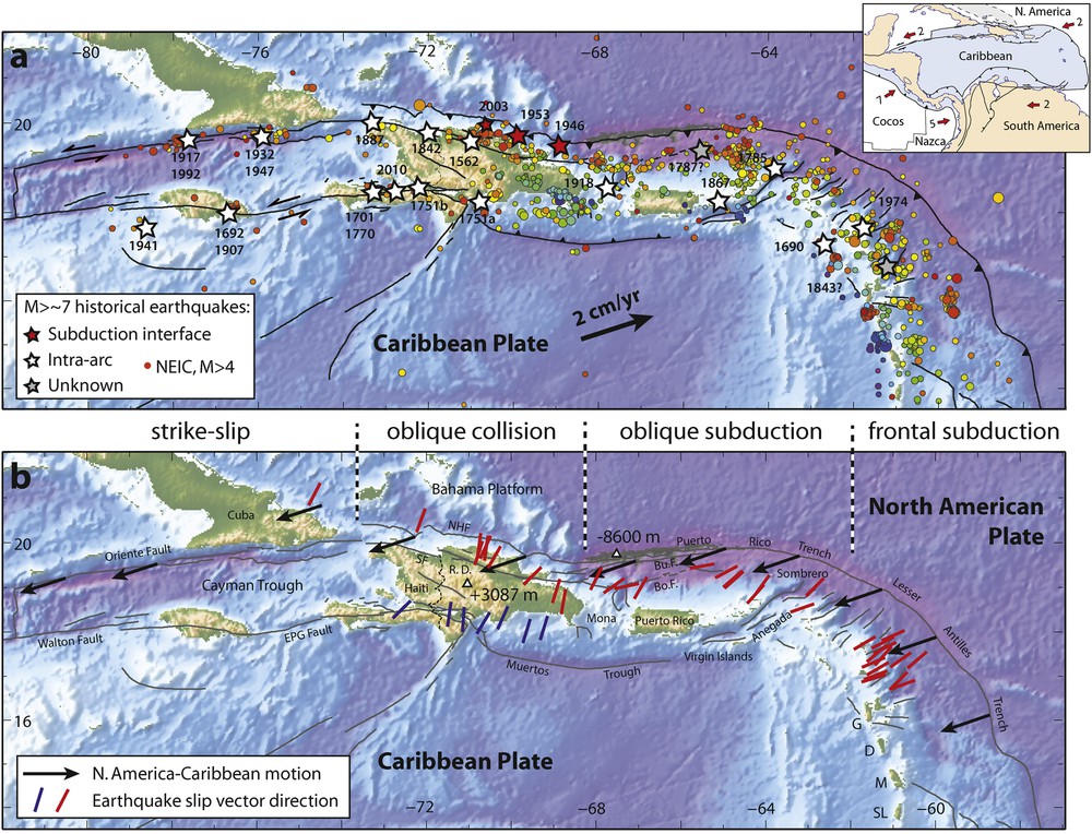
(Color online.) Seismicity and kinematics of the NE Caribbean. The inset shows Caribbean and surrounding plates, red arrows show relative motions in cm/yr: a: NEIC seismicity 1974–2015 is shown with circles colored as a function of depth, stars show large (M > 7) instrumental and historical earthquakes; b: red and blue bars show earthquake slip vector directions derived from the gCMT database [www.globalcmt.org], black arrows show the present-day relative motion of the NA plate with respect to the Caribbean.
This transition from subduction to strike-slip is associated with a geologically persistent segmentation of the plate boundary. Puerto Rico and the Virgin Islands (PRVI) show low-lying topography formed by an Oligocene–Early Pliocene carbonate platform (Moussa et al., 1987) deformed into a broad arch (van Gestel et al., 1998) exempt of significant active faults and apparently behaving as a single rigid block (Byrne et al., 1985; Jansma et al., 2000; Masson and Scanlon, 1991). To the north, the PRVI block is bounded by large, north-dipping normal faults that collapse Late Tertiary carbonates toward the Puerto Rico Trench (Le Pichon et al., 1985). Earthquake slip vectors on the Puerto Rico subduction interface are parallel to the Caribbean-North America (NA) relative plate motion (Fig. 1b), therefore suggesting oblique subduction without strain partitioning (McCaffrey, 2002).
In contrast, most of the island of Hispaniola to the west shows evidence of significant recent deformation with major active left-lateral strike faults and the highest elevation of the Caribbean Islands at Pico Duarte (3087 m, Fig. 1b). To the north, Hispaniola is currently colliding with the edge of the Bahamas Platform as evidenced by offshore compressional structures (Dolan et al., 1998; Mann et al., 2002) and by the occurrence of the M8.1 1946 reverse faulting and tsunamigenic earthquake (Dolan and Wald, 1998). Earthquake slip vectors along the North Hispaniola plate interface are highly oblique to the Caribbean–NA relative plate motion (Fig. 1b), suggesting the partitioning of strain across that segment of the plate margin (Calais et al., 2002).
These seismotectonic observations have recently been complemented by geodetic measurements of plate boundary deformation using the Global Positioning System (GPS). GPS measurements in the Caribbean go back to the late 1980s (DeMets et al., 2000; Dixon et al., 1998; Jansma et al., 2000), but only recently have we access to sufficiently dense measurements to determine both the kinematics of rigid-body motions within the plate boundary zone and of strain accumulation on major faults (Benford et al., 2012; Calais et al., 2002; Mann et al., 2002). Here we update the most recent solution of Symithe et al. (2015) with new measurements at episodic sites in Haiti and an additional 1.5 year of observations at continuous GPS sites throughout the region. We focus on the NE Caribbean plate boundary, where ∼ 200 continuous and episodic GPS sites can currently be used for deformation measurements. We identify plate-boundary perpendicular shortening in south-central Haiti, a feature that had not been reported before. It appears continuous to the west with the Muertos Trough. Using the GPS-derived kinematic model as an ending point, we propose a reconstruction of plate boundary kinematics in the NE Caribbean during the past 20 Ma.
2 Geodetic data and velocities
We process the GPS data using the methodology described in Symithe et al. (2015) using the GAMIT–GLOBK software package (Herring et al., 2010) to obtain a position–velocity solution expressed in the International Terrestrial Reference Frame (ITRF, version 2008) (Altamimi et al., 2011). To optimally tie the solution to the ITRF, we combine our regional solutions with global daily solutions of the global International GNSS Service (IGS) network. Our Caribbean-wide solution contains 375 sites, of which 236 are located in the NE Caribbean. To ensure reliable tectonic interpretation, we only retain episodic sites that have been observed at least four times and continuously recording ones that have at least 2.5 years of continuous measurements. We then visually inspect the velocities and manually remove outliers on the basis of their agreement with nearby stations. Velocity uncertainties vary as a function of the observation time span and reach 0.5 mm/yr for the oldest stations with ∼ 20 years of continuous data.
Since our solution is global, we define a NA-fixed reference by minimizing velocities at all sites located within the stable part of the North American continent between longitudes 110° W–55° W and latitudes 25° N–45° N (Calais et al., 2006). Defining and implementing a Caribbean-fixed frame is more difficult because of the limited number of sites located within the–mostly oceanic–stable part of the Caribbean plate. The kinematic model described below however indicates that nine sites covering the entire Caribbean basin and its edges fit a rigid Caribbean plate within uncertainties, with a reduced χ2 of 0.905 (CRO1, VIKH, CN08 CN29, SAN0, CN35, CN10, CN11, and AVES).
The resulting velocities show a number of important features (Fig. 2). Firstly, the left-lateral motion between the Caribbean and NA plates at 17–19 mm/yr is visible (sites CN14, PSLT, ROJO, CRO1, VIKH). This relative motion is slightly oblique to the plate boundary direction in Hispaniola, nearly parallel to the Puerto Rico trench, then progressively transitions to a direction perpendicular to the subduction trench further east and south in the Lesser Antilles.

(Color online.) Velocities at selected GPS sites in the NE Caribbean shown with respect to the Caribbean plate (a) and to the North American plate (b). Error ellipses are 95% confidence.
Within the plate boundary, contrasted deformation regimes are apparent. Velocities in Puerto Rico, the Virgin Islands, and the northern Lesser Antilles in a Caribbean frame are all less than 1.5 mm/yr and usually contained within their 95% confidence ellipses. This area therefore shows very little motion with respect to the Caribbean plate and little internal deformation. Velocities in Hispaniola show a distinctly different pattern, with a north–south velocity gradient. Sites on the southernmost coastline (e.g., PSLT and ROJO) show velocities consistent with the Caribbean plate motion while sites in the north show velocities consistent with the NA plate motion (Fig. 2a), but with slightly reduced magnitudes. This velocity gradient corresponds to up to 15 mm/yr of integrated left-lateral shear strain across the island. In addition, Fig. 2a shows that a component of plate boundary–normal shortening superimposes onto the east–west left-lateral shear. This shortening affects the central and western parts of Hispaniola, except the southern Peninsula of Haiti west of 72.5° W, where velocities in a Caribbean frame are parallel to the east–west-trending Enriquillo fault.
Finally, velocity differences between the Puerto Rico block and eastern Hispaniola imply ∼ 3 mm/yr of extension across the Mona Passage, consistent with findings from earlier GPS measurements (Jansma et al., 2000) and with offshore evidence for east-west directed extensional faulting between Puerto Rico and Hispaniola (Chaytor and ten Brink, 2010; van Gestel et al., 1998). To the east, velocities at sites located on either side of the Anegada Passage are similar, with differences ≤ 1 mm/yr and within measurement errors. This indicates little relative motion across the Anegada Passage, consistent with limited evidence for active deformation within the Virgin Island and Sombrero basins (Chaytor and ten Brink, 2015; Laurencin, 2014; Raussen et al., 2013).
3 Strain rates in Hispaniola
We now use GPS velocities to compute strain rates in Hispaniola. We first interpolate the horizontal velocities on a regular 0.3 × 0.3 degree grid, then compute strain rate tensors for individual grid elements from the horizontal gradient of the interpolated velocity field using standard formulas (Malvern, 1969).
The strain rate field (Fig. 3) shows that deformation concentrates on two east–west stripes in the northern and southern parts of the island, coincident with the location of the Enriquillo (south) and Septentrional (north) fault zones. The rest of the island, in particular the Cordillera Central and most of southeastern Hispaniola, deforms at much slower rates except for a higher strain rate region across central Haiti. This latter region could represent the eastern boundary of the Gonave microplate (Benford et al., 2012; Symithe et al., 2015), but may also be an artifact of the station distribution. That the central part of the island experiences relatively low strain rates may indicate that this region is mechanically stronger than its surroundings or that compressional stresses from the Caribbean–NA oblique convergence are not transferred that far south of the North Hispaniola–Puerto Rico trench.
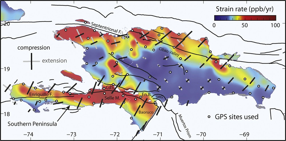
(Color online.) Map of GPS-derived strain rates in Hispaniola. The white dots show the location of the GPS sites that were used to interpolate the velocities. The background color shows the second invariant of the strain-rate tensor. Crosses show the principal axis of the strain-rate tensor, compressional in black, extensional in grey. CdS: Cul-de-Sac basin; En.B.: Enriquillo basin; SMG: Sierra Martin Garcia.
Principal strains in northern Hispaniola (50–80 ppb/yr) are consistent with left-lateral shear on the Septentrional Fault. NE–SW–directed maximum compression is consistent with the oblique collision of the southeastern-most Bahamas banks with NE Hispaniola (Dolan et al., 1998). In the south, the western half of the Southern Peninsula of Haiti (west of ∼ 73° W) shows principal strains (30–50 ppb/yr) consistent with left-lateral shear on the Enriquillo fault. The eastern part of the Enriquillo fault (east of ∼ 72.5° W) across the Cul-de-Sac (Haiti) and Enriquillo (Dominican Republic) basins shows little shear, but significant compression in an NNE–SSW direction. This observation is at odds with the common interpretation of the Enriquillo fault being a vertical left-lateral strike-slip fault throughout southern Hispaniola, with only minor en échelon drag folds in the surrounding sediments (Mann et al., 1995). This NNE–SSW compression rotates slight to a more NE–SW direction from west to east, consistent with the recent compression reported along the northern edge of the Sierra de Bahoruco in the Dominican Republic and in the Sierra Martin Garcia (Hernaiz Huerta and Diaz de Neira, 2007). This compression likely continues offshore, as indicated by shortening in the western part of the Muertos accretionary prism (Granja Bruña et al., 2014; Ladd et al., 1977).
4 Kinematic block model
We now use the GPS velocities described above to jointly estimate rigid block rotations and strain accumulation rates on major active faults McCaffrey (2002); Meade and Loveless (2009); Symithe et al. (2015). The model (Fig. 4) assumes that the NE Caribbean consists of four rigid blocks in between the Caribbean and NA plates, with block boundaries coinciding with the major known active faults. To the west, the Gonave block is bounded to the south and the north by the Enriquillo and Oriente faults, respectively. Its eastern boundary remains debated; we used the solution favored by Symithe et al. (2015), who make that boundary correspond to the Plateau Central–San Juan Valley area across Haiti and the Dominican Republic. Benford et al. (2012), using a sparser GPS data set, favored a location along the Neiba–Matheux thrust. The GPS data require splitting Hispaniola into two blocks, but deformation may be distributed over a broader region than that assumed in the models. The Hispaniola block is bounded to the south and north by the western part of the Muertos Trench and the Septentrional Fault, respectively, and to the east by the actively opening Mona Passage (Chaytor and ten Brink, 2010). The Puerto Rico block is bounded to the south and the north by the eastern part of the Muertos Trench and the Puerto Rico Trench, respectively, and to the east by the Anegada Passage fault system through the Virgin Islands and Sombrero basins. Plate coupling is estimated along the North Hispaniola Fault–Puerto Rico Trench–Lesser Antilles Trench subduction interface, while all other faults are assumed to be locked to a depth of 15 km (Symithe et al., 2015).

(Color online.) Best-fit kinematic block model. Dashed blue lines show block boundaries, with block names labeled in blue. Thin red lines show actual fault traces. Colored arrows show predicted relative block motions with velocity indicated in mm/yr. Velocity error ellipses are 95% confidence. Enr.F.: Enriquillo fault; CdS: Cul-de-Sac basin; Mat.: Mattheux massif; Nei.: Sierra de Neiba; PCSJV: Plateau Central–San Juan Valley; Sep.F.: Septentrional Fault; Vi.B.: Virgin Island Basin; Som.B: Sombrero Basin.
The data matches well the block geometry imposed in the model, with residuals that are well below the measurement uncertainties over most of the area, except for the northern edge of the southern Peninsula and the area of the Cul-de-Sac basin in Haiti. In those two areas, residual velocities, although small, show a systematic pattern indicating that the model is likely missing a small amount of north–south shortening. The Puerto Rico–Virgin Island region shows no evidence of internal deformation at the ∼ 0.5 mm/yr level, indicating that current slip on active faults such as the Cerro Golden–Great Southern fault zone (Grindlay et al., 2005b; Mann et al., 2005) occurs at a very slow rate.
The model predicts features that are generally consistent with independent geological or seismological observations. Model slip rates on the Oriente–Septentrional Fault range 9–11 mm/yr, which is consistent with previous geodesy and paleoseismology estimates (Manaker et al., 2008; Prentice, 2003). The model shows convergence at 2–3 mm/yr on the North Hispaniola fault, which is consistent with the source mechanisms of the 1946 (Dolan et al., 1998) and 2003 (Dolan and Bowman, 2004) earthquakes off the northern coast of the Dominican Republic. It predicts moderate convergence (1–5 mm/yr from north to south) across central Hispaniola. Present-day deformation in this area is consistent with historical earthquakes in 1761 and 1911 (M6.9?) (Scherer, 1912). The model shows oblique shortening across the western part of the Muertos trough at rates up to 7 mm/yr, decreasing to ∼ 1 mm/yr in its eastern part. It indicates little motion (< 1.5 mm/yr) across the Anegada Passage. Finally, the model predicts slip on the Puerto Rico Trench in a direction that is highly oblique to the trench, consistent with slip vectors of instrumental earthquakes (Fig. 1b), at a rate close to that of the full Caribbean–NA relative motion. A portion of that motion could however be accommodated by slip on the shallow Bowin and Bunce strike-slip faults in the inner wall of the Puerto Rico trench (Grindlay et al., 2005a; ten Brink and Lin, 2004).
5 Discussion
5.1 Present-day kinematics
The geodetic observations described above show that the NE Caribbean plate boundary is fragmented into three main blocks: Gonave, Hispaniola, and Puerto Rico, with little present-day internal deformation. The highly oblique Puerto Rico subduction is associated with ≤ 5 mm/yr of plate boundary–normal convergence and is found to be uncoupled, hence transmitting little stress to the upper plate. This probably explains the absence of significant recent geological deformation in Puerto Rico, where undeformed Miocene to Pliocene strata overlay folded and faulted Late Jurassic to Eocene rocks (Dolan et al., 1991). The highly oblique and uncoupled Puerto Rico subduction evidenced here does not support a model where compressive stresses imparted by plate convergence would be efficiently transmitted into the back-arc region and explain back-arc thrusting at the Muertos trough (ten Brink et al., 2009).
Masson and Scanlon (1991) argued for strike-slip motion rather than convergence at the Puerto Rico trench and proposed a model where the plate boundary is a strike-slip fault of moderate dip. This is consistent with our geodetic measurements, with 70–80% of trench-parallel motion and only 20–30% of convergence at the Puerto Rico trench. In their model, the 25 counterclockwise rotation or the Puerto Rico block between 11–4 Ma (Reid et al., 1991) is a result of this left-lateral shear. Their model explains the decreasing amount of shortening observed from west to east along the Muertos Trough, and extension through the Anegada Passage and Mona Passage. Geodetic measurements also indicate a slow counterclockwise rotation of the Puerto Rico–Virgin Island block with respect to the Caribbean plate and opening of the Mona Passage. By contrast, we find very little–if any–current motion across the Anegada Passage, where evidence of recent deformation is also lacking in recent offshore surveys (Chaytor and ten Brink, 2015; Laurencin, 2014). This suggests that the morphotectonics of the Anegada Passage may not be representative of the present-day plate boundary kinematics, but rather reflects an older tectonic regime. Nevertheless, Masson and Scanlon's (1991) conceptual model of passive entrainment of the PRVI block within a broad zone of left-lateral shear remains appealing in view of the geodetic observations.
An alternate model was proposed by Stéphan et al. (1985), who interpreted the northern and southern Caribbean “festoons”, i.e., the Muertos, Colombia, and Venezuela accretionary prisms, as a result of the inward bending of crustal slivers due to east–west compression within the south and north boundaries of the Caribbean plate. In this interpretation, the bending of the Greater Antilles arc would drive overthrusting of the Puerto Rico–Hispaniola sliver onto the Caribbean basin, hence forming the Muertos back-arc thrusting and accretionary prism. This model explains well the lack of shear within these accretionary prisms, with only plate boundary–normal shortening. However, it is not consistent with current geodetic observations showing fragmentation of the Puerto Rico–Hispaniola sliver into two blocks separated by the active Mona Passage, and contradicts the present-day east–west extension observed along the plate boundary.
On the basis of early GPS measurements and offshore observations in the NE Caribbean (Calais et al., 2002; Jansma et al., 2000), Mann et al. (2002) proposed that the oblique collision of the Bahamas Platform with northern Hispaniola (Dolan et al., 1998) was an essential contributor to regional-scale plate boundary deformation. Hispaniola's eastward motion with respect to NA would have been slowed down by compressional forces imparted by the collision, likely initiated in the Pliocene (Calais et al., 1992; De Zoeten and Mann, 1999). This would have resulted in the segmentation of the plate boundary, as the collision-free Puerto Rico–Virgin Islands block could continue moving eastward at a velocity close to that of the Caribbean plate. This interpretation is consistent with the transition from an uncoupled (Puerto Rico Trench) to a coupled (North Hispaniola fault) plate interface coincident with the present-day contact between the southernmost Bahamas banks and NE Hispaniola. Interplate coupling on the North Hispaniola fault would then allow the stresses imposed by the Caribbean-NA relative motion to be transmitted to the overriding plate. This, in turn, may allow for the activation of the observed strike-slip faulting and shortening within Hispaniola.
An alternative or complementary process may be the lateral push exerted onto the Caribbean plate by the edge of the NA slab under eastern Hispaniola (van Benthem et al., 2014). However, the existence of a continuous slab in this region has been challenged, its geometry through time is poorly constrained, and it is unclear against what, specifically, the slab edge would be pushing.
Finally, buoyancy forces arising from lateral gradients in gravitational potential energy, usually neglected in conceptual or even mechanical models, may also contribute to the force balance driving plate boundary deformation in the NE Caribbean. The geoid shows a north–south gradient of 35 m over 150 km between the Puerto Rico Trench and the Island of Puerto Rico at longitude 66.5° W. By comparison to other regions (Stamps et al., 2014), this gradient could generate deviatoric stresses on the order of 10–15 MPa, equivalent to a net force per unit length of 10–15 TN/m for a 100-km-thick lithosphere. This is comparable to the slab pull force, a major contributor to plate motions (Conrad and Lithgow-Bertelloni, 2002; Schellart, 2004). Quantifying the actual contribution of gravitational forces to regional tectonics over time is beyond our scope, but is an important objective for future research.
5.2 Neogene kinematic reconstruction
In keeping with efforts initiated in the late 1980s (Calais et al., 1989; Pindell et al., 1988; Ross and Scotese, 1988; Stéphan et al., 1990), we propose a paleo-kinematic reconstruction of the NE Caribbean region for the Neogene (Fig. 5). To do so, we extrapolate the present-day kinematics directly derived from geodetic measurements back in time while accounting for geological information.

(Color online.) Interpretative reconstruction of the regional kinematics since the Lower Miocene. The present coastlines are kept trough time in order to follow the motions of the various blocks. Red lines are major active faults. The motion of the Caribbean plate is assumed to be similar to the present-day one. Cayman trough's magnetic anomalies are from Leroy et al. (2000), the locations of Baracuda–Main Ridge, of the Jacksonville Fracture Zone and of the Atlantic magnetic anomalies are from Pichot (2012). Yellow: North American plate. Blue: Caribbean plate. Darker blue: oceanic Caribbean basin. Orange: Bahamas platform. The hatched area represents the eastern boundary of the Gonave microplate as a broad deformation zone coincident with the Haiti fold-and-thrust belt.
At 20 Ma, the Caribbean plate is likely moving in a direction similar to the current one, as imposed by the orientation of transform faults on either sides of the Cayman Trough. The spreading rate at the Cayman oceanic ridge appears constant at 10 mm/yr since anomaly 6 (Leroy et al., 2000), suggesting that the velocity of the Gonave plate with respect to NA has been similar to the present-day one over the past 20 Ma. We used the position of the Caribbean plate at 20 Ma from the reconstruction of Stéphan et al. (1990), based on the geological record of the eastward progression of a compressional deformation front along the southern boundary of the Caribbean plate in Venezuela (Stéphan, 1982). In Hispaniola, a collisional wedge (Haiti fold-and-thrust belt) starts forming in the Early Miocene as a result of oblique convergence between the Caribbean oceanic crust and the cretaceous island arc basement of the Greater Antilles (Pubellier et al., 1991). It is continuous to the west with the proto-Muertos Trough, with a deformation front migrating southwestward in time until the Upper Pliocene (Pubellier et al., 2000).
The position of the Caribbean and Gonave plates with respect to NA imply that the Enriquillo fault initiated between 20 and 10 Ma. This is consistent with Lower Miocene (20–18 Ma) sedimentation observed along the trace of EPGFZ: in Jamaica, high-energy clastic marine sedimentation begins around 20–18 Ma above a major unconformity (Katz and Miller, 1993; Mitchell, 2013); along the Southern Peninsula of Haiti, the strike-slip-related basins of Camp-Perrin and L’Asile initiate in the Lower Miocene with shallow-water to continental sediments (Bizon et al., 1985); around Port-au-Prince, the deposition of the clastic fan-shaped marine Morne Delmas formation starts in the Lower Miocene (Butterlin, 1977), indicating that the onset of the relief along the southern edge of the Cul-de-Sac Plain, most likely related to the initiation of the EPGFZ in this area, is 20-18 Ma old.
At 10 Ma, the Enriquillo fault is a left-lateral fault separating the Gonave plate from the Caribbean plate. It is the onset of the 11–4 Ma 25° counterclockwise rotation of Puerto Rico (Reid et al., 1991). Fig. 5 shows that the Puerto Rico block had cleared the southern tip of the Bahamas platform by 10 Ma and was therefore facing the Lower Cretaceous Atlantic oceanic crust. We propose that this situation created an oceanward gravitational pull sufficient to trigger the counterclockwise rotation of the Puerto Rico block. Other mechanisms such as slab tear (ten Brink, 2005) may have added to the tensional stresses. As a consequence of this rotation, deformation occurred between Puerto Rico and the rest of the arc, with extension in the Mona and Anegada passages, and in the Sombrero and Virgin Islands basins.
The 10-Ma configuration persists until ∼ 5 Ma. The deformation front of the Haiti fold-and-thrust belt continues propagating southwestward, progressively closing the Enriquillo–Cul de Sac basin. The southern peninsula of Haiti eventually abuts against the rest of Hispaniola, resulting in the folding and uplift of the Massif de la Selle and Sierra de Bahoruco (Fig. 3). This is supported by changes in carbonate depositional environments in the Selle–Bahoruco massifs indicative of uplift initiation during Middle Miocene (Maurrasse et al., 1979). By Pliocene time, the Selle–Bahoruco terrane and most of the southern Peninsula of Haiti had emerged (van den Berghe, 1983).
A significant change occurs at ∼ 2 Ma with the onset of the uplift of the Cordillera Septentrional (Dominican Republic) along the transpressional Septentrional Fault, bringing Upper Miocene shallow water carbonates to a current elevation of 1250 m (Calais et al., 1992; De Zoeten and Mann, 1999). This is also the time when the Septentrional Fault initiated (Calais et al., 1992). Convergence on the North Hispaniola subduction slows down significantly (to < 4 mm/yr today), probably as a result of the collision with the Bahamas platform (Dolan et al., 1998; Mann et al., 2002). The relative motion between the North American plate and Hispaniola–Puerto Rico is now accommodated by left-lateral slip on the Septentrional Fault at ∼ 10 mm/yr. A northern Hispaniola sliver forms, in the process of being captured by the NA plate.
Further east, the Puerto Rico–Virgin Island block–with little evidence of deformation since the Early Miocene–undergoes significant vertical motion, as shown by shallow-water Early Pliocene limestone currently located up to 5000 m below sea level on the offshore slope north of Puerto Rico (Le Pichon et al., 1985; Moussa et al., 1987). Puerto Rico is devoid of Neogene compressional deformation. Miocene–Early Pliocene shallow limestones of the Quebradillas formation dip to the south by ∼ 4°as a result of regional tilting, most likely associated with the collapse of the northern Puerto Rico slope (Grindlay et al., 2005a, 2005b; Moussa et al., 1987). Everything therefore indicates that the subduction of the Atlantic oceanic lithosphere under Puerto Rico was associated with an extensional tectonic regime, at least since ∼ 3 Ma. We hypothesize that strike-slip motion on the Septentrional Fault propagated to the east through the Mona Passage and onto the Bowin fault (Fig. 1). In this configuration, the Puerto Rico Trench, bounded to the north by the highly–obliquely convergent subduction interface and to the south by the left-lateral strike-slip Bowin fault, is essentially a transtensional system. This may facilitate the observed subsidence of the outer and inner trench walls and explain why the subduction trench is so much deeper there than anywhere else along the NA–Caribbean convergent margin.
6 Conclusion
The Caribbean–NA plate boundary in the NE Caribbean shows an example of along-strike transition from typical frontal subduction in the Lesser Antilles, to oblique subduction with no strain partitioning in Puerto Rico, to oblique subduction/collision with strain partitioning further west in Hispaniola (McCann and Sykes, 1984; Calais et al., 2002). The transition from the absence of strain partitioning to strain partitioning is remarkable because it coincides with the current onset of the oblique collision of the Bahamas platform with the island arc in NE Hispaniola (Dolan et al., 1998; Mann et al., 2002). This transition is correlated with (1) a significant change in the plate boundary strain regime from transtensional in Puerto Rico to transpressional in Hispaniola, (2) the location of the largest instrumental earthquakes in the NE Caribbean (Dolan and Wald, 1998), (3) the eastern termination of large strike-slip faults well developed in Haiti and further west in Jamaica and along the southern Cuban margin, (4) a 3000 m high, uncompensated, mountain range in the Dominican Republic (Cordillera Central) adjacent to the deepest trench in the Atlantic ocean at −8600 m, and (5) plate boundary-perpendicular extension between Hispaniola and Puerto Rico in the Mona Passage (Chaytor and ten Brink, 2010; Mondziel et al., 2010).
That this segmentation is equally well marked in the current interseismic strain as measured by GPS and the recent deformation regime as derived from geological data is an important observation. It implies that interseismic segmentation is persistent over long time intervals and is therefore likely inherited from the geological history of the plate boundary. This result is relevant to the assessment of seismic hazard at convergent plate boundaries, where geodetic measurements often show interseismic segmentation between fully–and partially–coupled plate interface regions (Loveless and Meade, 2010; Nocquet et al., 2014). Interseismic coupling, hence maximum earthquake size, may have much to do with the geological history and long-term properties of plate boundaries.
Acknowledgments
Jean-François Stéphan triggered many of the ideas discussed in this paper. The campaign GPS data used in this study were collected as part of the “CANAPE” (CAribbean North America Plate Experiment) project with support from the “Direccion General de Mineria”, the “Instituto Cartografico Militar”, the “Colegio Dominicano de Ingenieros, Arquitectos y Agrimensores” (CoDIA), and Holasa S.A. in the Dominican Republic, and from the “Bureau des mines et de l’énergie”, the “Direction de la protection civile”, the “Centre national de l’information géo-spatiale”, and the “Faculté des sciences de l’université d’État” in Haiti. We used all publicly available continuous data from various providers, in particular the “COCONet” (Continuously Operating Caribbean Observation Network, coconet.unavco.org) international initiative and the U.S. “CORS” network (Continuously Operatiing Reference Stations geodesy.noaa.gov/CORS/. This paper benefited from reviews by Uri ten Brink and Paul Mann, and by Associate Editor Isabelle Manighetti. This research was supported by a COCONet fellowship from UNAVCO to SS and National Science Foundation awards EAR-0409487, EAR-RAPID-1024990, and EAR-1045809 to EC.