

1 Introduction
Since the Cenozoic up to the present, Southeast Asia has been a puzzle of micro-plates partially amalgamated onto the Sunda plate margins (Rangin et al., 1990). These micro-plates are themselves fragmented into various platelets. Their overall motions and deformations have been mainly driven, since the Early to the Mid-Cenozoic (Rangin, 1991), by the northward oblique convergence of the Philippine Sea Plate (PSP), and by the northward highly oblique convergence of the Indian plate (IP). In the South, the northward convergence of the Australian Plate (AP) has induced a complex mosaic of platelets that extend from the Papua New Guinea Belt in the East to Southeast Indonesia (Banda Sea). The relative motion of the plates and micro-plates is well constrained by geodetic and seismotectonic studies (Michel et al., 2000; Simons et al., 1999).
Fig. 1 shows the main SE Asia tectonic plates and their zones of interaction: these micro-plates are the Philippine “Mobile Belt” (PMB, Rangin et al., 1990) in the East, a complex assemblage of platelets (or crustal blocks) jammed between the Philippine Sea Plate and the Sunda Plate, the Myanmar–Andaman–Sumatra (MAS) micro-plate in the West, and the Papua New Guinea Belt (PNGB) micro-plate in the South. These three zones are referred to as micro-plates because they form a “buffer zone” between converging major plates.
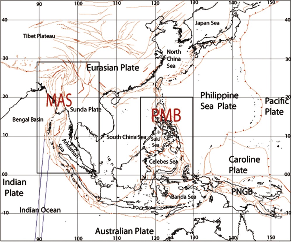
Deformation of Southeast (SE) Asia with location of the Philippine Mobile Belt (PMB) and the Myanmar–Andaman-Sumatra Belt (MAS) discussed in this paper (modified from Pubellier et al., 2005). Active and/or recent faults are showed with red lines.
In this paper, we analyze the PMB and MAS micro-plates complex zones to examine their rigidity. We question whether these zones are well described by rigid blocks or platelets, or are rather affected by non-rigid, evenly distributed deformation.
2 The Philippine Mobile Belt
The PMB (Fig. 2) is a 2500-km-long, north–south-trending, composite terrane extending from Luzon Island in the North to the Molucca Sea in the South (Rangin, 1991; Stéphan et al., 1986). It is fringed to the west by a succession of short subduction zones (Manila, Negros and Cotobato trenches) and collision zones (Palawan–Mindoro–Panay–Moluccas).
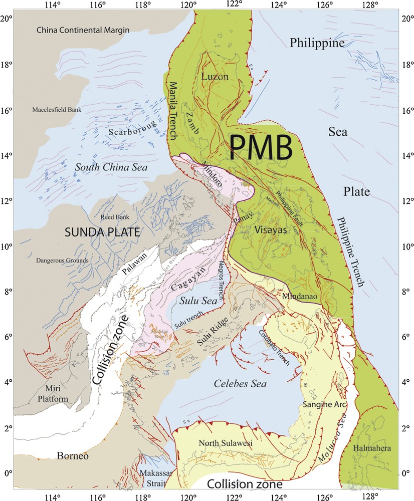
Tectonic and geological units in the Philippine Mobile Belt (PMB) micro-plate (modified from Pubellier et al., 2005). Basins floored by oceanic crust are in light blue; magnetic anomalies in violet; active faults and folds in red; inactive faults in black; faults whose activity is unknown in blue. Accreted terranes to PMB from the Philippine Sea Plate are shown in green. Conjugated continental margins terranes from the South China Sea are in gray, the Cagayan Ridge terranes in violet, the South Borneo-Sulu Ridge terranes in light brown and the North Sulawesi-Sangihe arc in yellow. Main collision zones (active or not) are in white.
In the East, the Philippine Trench extends from Luzon Island to the Molucca Sea, where it connects with the Sangihe Trench.
The Philippine fault is a major left lateral strike-slip fault that cuts through the entire PMB, from northern Luzon (Pinet and Stéphan, 1990) to the Davao Gulf in the Mindanao Island (Quebral et al., 1996), up to the Masbate/Leyte Islands in the central part of the Philippine Archipelago (Aurelio et al., 1991). That major fault is taken to accommodate the partitioned lateral component of the oblique plate motions (Hamburger et al., 1983).
Active PMB/Sunda relative motion has been measured by GPS during the Geodetic GEODYSEA European program (Michel et al., 2000; Simons et al., 1999) and shows a N30°E-oriented convergence at a rate of 9.6–9.8 cm/yr.
The PMB is formed of various, independent, accreted blocks originated from both the Eurasia and the Philippine Sea plates (Rangin, 1991). In the following, we will refer to these blocks as “platelets”.
Blocks originated from the West Philippine Plate are Mesozoic and Paleogene island arc terranes imbricated with Mesozoic ophiolites. They are pieces of the former active margin subduction complexes that were bordering the oceanic Philippines Sea Plate. They were subsequently accreted to the PMB as the Philippine Sea Plate was rotating clockwise with respect to Australia. The most significant units are presently exposed in the eastern part of the Cordillera of Luzon (Pinet and Stéphan, 1990; Ringenbach et al., 1993), in the Visayas (Rangin et al., 1990) and in most of the Mindanao Island (Pubellier et al., 1996). In all these areas, volcanic and ophiolitic terranes were amalgamated, then sealed by the Late Oligocene disconformity recognized in the Mid- to Late Cenozoic PMB sedimentary basins.
Blocks of the Eurasian plate, mainly pieces of the rifted and drifted continental margin of China, were also transferred to the PMB.
During the Early to Mid-Cenozoic, the China continental margin was extensively rifted. Partial oceanic spreading occurred in the South China Sea and in the Celebes Sea. These rifting/spreading processes were likely induced by subduction rollback along the North Sulawesi-Sangihe volcanic arc (Rangin et al., 1990). This arc collided with the Australia continental margin (“Buton block”, Smith and Silver, 1983) during the Early–Middle Miocene. Southward, the Sangihe volcanic arc is presently colliding with the Hamahera arc, in the Molucca Sea (Pubellier et al., 1996).
The PMB is fringed by subduction zones with opposite vergencies (Hamburger et al., 1983), as clearly revealed in tomographic images (Rangin et al., 1999a). Along the Eastern PMB margin, the West Philippine Basin subducts westward along the Philippine Trench. To the west, part of the PHP/Sunda Plate convergence is absorbed across the Manila, Negros and Cotabato subduction zones, and in the Mindoro Panay and Mindanao islands collision areas.
Global kinematic models show that the Philippines Sea Plate is currently rotating clockwise with respect to Eurasia and Sunda, about an Euler pole close to central Japan (Barrier et al., 1991; Rangin et al., 1990; Fig. 3). Tectonic and GPS data (Michel et al., 2000) show that the principal deformations of the PMB are well described with a rigid-platelet model (Rangin et al., 1999b; Fig. 3). In such a simple model, two opposite rigid rotations occur on either side of the left lateral Philippine Fault. The Luzon and the East Philippine Sliver platelets are rotating counterclockwise with respect to the Eurasian Plate, with the same velocity as the Philippine Sea Plate.
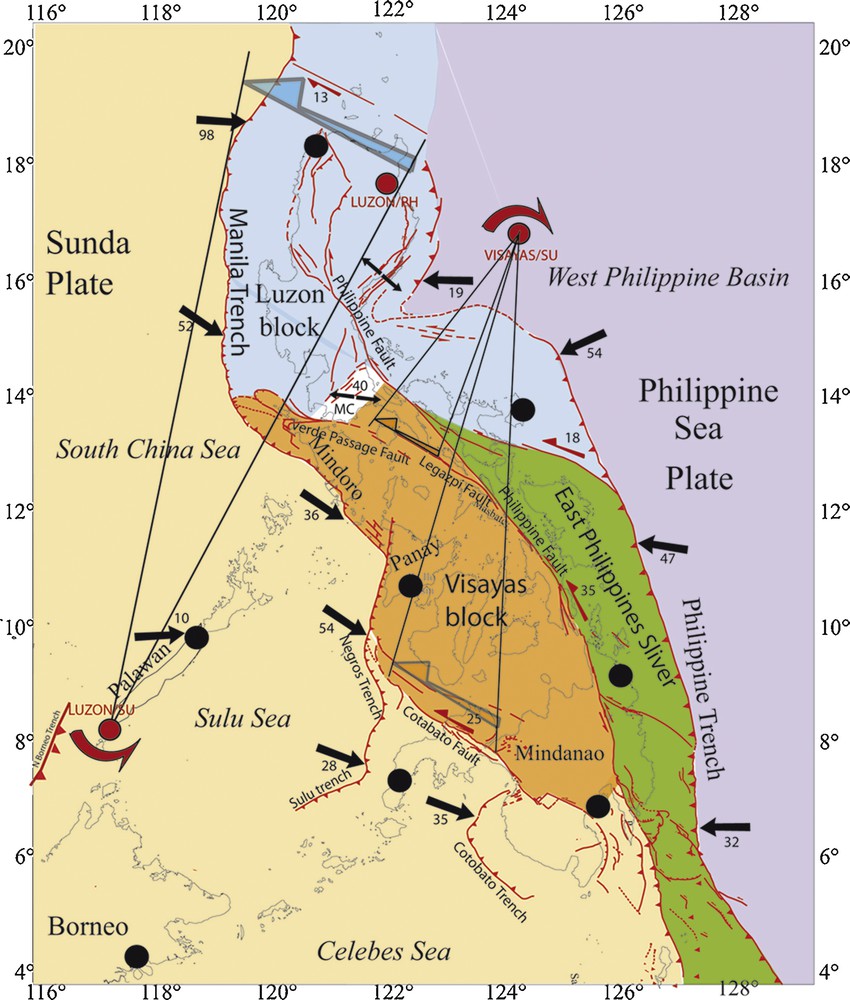
Rigid-platelets model accounting for recent and current deformations in the Philippine Mobile Belt (PMB) (modified from Rangin et al., 1999a). Active faults are in red. Faults within blocks are minored in the sketch. See text for more details.
The Visayas platelet rotates clockwise with respect to Sunda, and its northern boundary acts as a cogwheel allowing the westward translation of the Luzon block towards the Manila trench.
The rigid-platelet model above describes well the principal deformations in the PMB because, although the involved platelets sustain some internal deformation, the latter is low compared to the fast slip rates on the platelets-bounding major faults (Figs. 2 and 3). The overall kinematic pattern described by the rigid-platelets model suggests that subductions occur everywhere perpendicular to the trenches, as indicated by the relative motion vectors shown in black on Fig. 3.
3 The Myanmar–Andaman–Sumatra micro-plate (MAS)
In the South, the MAS includes the “Sumatra subduction wedge” (Fig. 4). From there, the AUS/Sunda convergence becomes progressively more oblique as one is going northward along the Sumatra subduction zone. North of 10°N, right lateral motion occurs in a north–south direction between the Andaman platelet and the lower subducting plates. From North Sumatra to the northern Andaman Sea, the subduction zone is dissected by numerous dextral strike-slip faults.
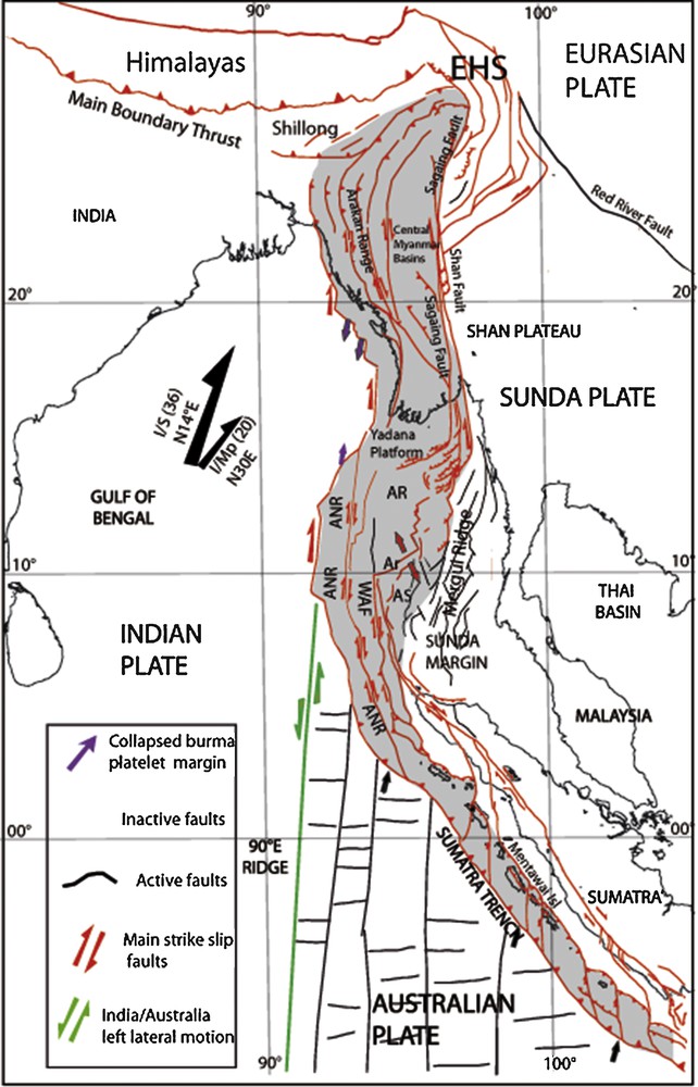
Tectonic map of the Myanmar–Andaman–Sumatra (MAS) micro-plate. MAS is shown in gray and active faults in red. Inactive faults in Sunda Plate margin are in black. The MAS micro-plate includes two platelets, the Myanmar Platelet in the North and the Andaman-Sumatra platelet in the South. Tectonic boundaries between platelets are diffuse. Small black arrows along the Sumatra trench are the Australia/Sunda relative motion. India/Sunda (I/S) relative motion is shown with a large black arrow (N14° azimuth and 36 mm/yr. velocity). India/Myanmar Platelet relative motion (I/MP) is shown with a smaller arrow (N30° azimuth and 20 mm/yr.). The north–south Mesozoic transforms and east–west-spreading faults of the Australian Plate Mesozoic oceanic crust are in black. The green line is an active left lateral fault zone present along the east flank of the “90°E Ridge”. It is part of the active diffuse India/Australia Plate boundary. EHS: East Himalaya Syntaxis; Ar: Andaman rift (red arrows indicate direction of extension); ANR: Andaman–Nicobar Ridge; AR: Alcock Ridge; AS: Sewell Ridge.
In northern Sumatra, the subduction wedge is also affected by dextral strike-slip faults fairly parallel to the wedge (Sibuet et al., 2004).
At the northern tip of Sumatra, the strike of the subduction zone changes abruptly to become more northerly trending and hence parallel to the “Indian Ridges” that mark the diffuse India/Australia plate boundary (in green on Fig. 4). Jing et al. (2009) have suggested that the Indian Ridges continue northward below the Sumatra wedge north of Sumatra. We note that such a northward prolongation coincides with intense north–south right lateral shearing in the subduction wedge (Fig. 4).
Further northward, in the upper plate, the western Andaman Sea is also dissected by north–south strike-slip faults such as the West Andaman Fault and the Mergui/Shan faults. These faults are dextral, which suggests that they accommodate part of the India/Sunda relative motion. The Andaman-Nicobar Ridge (ANR, Fig. 4) is generally interpreted as the subduction wedge related to the subduction of the Bengal basin (Curray et al., 1979). However, Rangin and Choi (2015) rather propose that it is a highly oblique convergent zone dominated by dextral lateral slip with only a minor (< 10%) amount of east–west shortening. On the basis of unpublished industrial seismic data, Rangin and Choi (2015) interpret the ANR belt as being made of north–south-trending Indian Ridge fragments that are being transferred to the MAS micro-plate through the westward migration of the India/MAS convergent front.
In the East, the central part of the Andaman Sea is an elongated volcanic plateau, whose major features are the Alcock and the Sewell Rises (AR and AS on Fig. 4). The AR and AS rises are bounded to the east by the Sagaing–Mergui and the Shan dextral faults, which form the MAS/Sunda tectonic boundary. The AR and AS volcanic rises are part of the so-called “oceanic Andaman Rift” (Curray et al., 1979), a narrow rift basin that has been affected by various Cenozoic extensional episodes (Morley and Alvey, 2015).
Curray et al. (1979) have interpreted the Alcock and Sewell Rises as being the volcanic arc that formed above the Andaman Subduction zone. However, there exists no sampling and dating data that would confirm this interpretation. The Alcock Rise extends northward in the northern Andaman Sea, where it forms the Yadana Rise. This rise has been intensively drilled and dated by oil companies. It is formed by Cretaceous volcanic agglomerates similar to those that form the basement of the “90°E Ridge” (Rangin et al., 2013; Fig. 4). Consequently, we interpret the Alcock rise as a fragment of Indian volcanic ridge that has been accreted to the Andaman plate. The same interpretation can be proposed for the Sewell Rise but no drilling data exists to validate this hypothesis.
The Andaman Alcock and Sewell Rises are dissected by a set of north–south dextral faults (West Andaman fault to the west and Shan-Mergui faults to the east). These faults accommodate a significant part of the India/Sunda highly oblique convergence (3.5 cm/yr), as shown by the Sumatra and the Sagaing faults, which each accommodates ∼ 2 cm/yr of dextral motion (Maurin et al., 2010; Prawirodirdjo et al., 2000; Vigny et al., 2003). These faults divide the Andaman platelet into narrow, north–south-trending sliver terranes. Because the faults accommodate a significant fraction of the north–south India/Sunda convergence, it is unlikely that they sustain any horizontal rotation. Furthermore, the slivers they bound are too long for horizontal rotations to be realistic. Therefore, the MAS platelet behaves as a relatively rigid zone.
The Burma platelet extends further north in the region of Myanmar. Offshore studies (seismic and bathymetry, Rangin et al., 2013) revealed that the western margin of this platelet is now an inactive subduction zone. This is supported by the seismological studies of Ni et al. (1989) and Guzman-Speziale and Ni (1996), which reveal compression P axes parallel to the slab, consistent with strike-slip faulting rather than thrusting. The western Burma continental margin and the Arakan range onshore are affected by numerous NNW–SSE-trending right lateral faults that accommodate a significant part of the India/Sunda motion (Socquet et al., 2006). These faults can be traced southward up to the Andaman Sea, where they are taken over by the WAF, ANR, and other Andaman dextral faults. The Burma and Andaman platelets faults have in common to be dextral. By contrast, they differ in strike: while the Andaman faults trend north–south overall, the Burma fault traces are convex overall towards the west; that is, from south (i.e., north to the Andaman Sea) to north (i.e., northern Myanmar, Bangladesh and eastern India), their average trend changes from NW–SE to north–south, and then to NE–SW (Maurin and Rangin, 2009a, 2009b). This confers to the Burma platelet a general westward convex shape (Fig. 5).

Tectonic map of the Burma platelet. India/Sunda motion is shown with black arrow. The suggested crustal flow along the East Himalaya syntaxis is indicated with a large red arrow. Same captions as in Fig. 4.
The central Myanmar basins show a similar curvature (Fig. 5). The Salin Basin in the south-central lowlands of Myanmar is trending NNW–SSE, whereas the Chindwin basin to the north is trending north–south and then NNE–SSW.
The westward convex deformation zone that affects the Burma platelet (Fig. 5) is bounded to the north by the right lateral Assam shear zone, and to the south by the left lateral Prome-Pyai shear zone (Fig. 5).
The question then arises to understand the reasons of the Burma platelet curvature. This curvature seems to have made the fault traces migrating more than 100 km away from their original north–south trend (see the Sagaing fault in its northern part; e.g., Maurin and Rangin, 2009b). Le Dain et al. (1984) proposed that the bending of the Burma platelet has resulted from the lateral extrusion of Indochina. However, this would make the bending achieved at about 15 Ma, which is inconsistent with the ∼ 10 Ma-old Sagaing fault (Curray et al., 1979) being bent. The curvature of the Salin and Chindwin basins is also taken to have occurred at ∼ 10 Ma (Pivnik et al., 1998). Therefore, we rather follow Burchfiel (2004) and Copley and McKenzie (2007) and interpret the bending of the Burma platelet as resulting from Late Neogene crustal flow around the East Himalaya Syntaxis (Rangin et al., 2013). The release of the topographic potential energy that had accumulated over the thickening of the Tibetan Plateau during the India-Eurasia collision induced the collapse of the Tibetan plateau. This collapse might have generated a circular clockwise crustal flow around the East Himalaya syntaxis. Because the Bengal Basin was a free boundary, the crustal flow could migrate westward at a fast rate. From the growth of the Late Neogene fold belt in Bangladesh and eastern India, that migration rate is estimated at ∼ 1 cm/yr over the last 10 Ma (Rangin et al., 2013).
If this interpretation were to be correct, it would imply the presence of a thin and hot crust below the Burma platelet, a hypothesis that seems supported by the shallow locking depth of the northern Sagaing fault (∼ 5 km, Maurin et al., 2010).
Another possible force to bend the Burma platelet would be its locking in-between the rigid Andaman platelet in the South and the Shillong Plateau-Main Himalaya ∼ east–west thrusts in the North, both acting as a buttress driven by the overall north–south convergence (Clark et al., 2005). In this case, the fast westward migration of the Burma platelet would likely induce disruptions of the sedimentary pile and hence massive submarine landslides and “décollements”, consistent with those imaged on seismic lines (Maurin and Rangin, 2009b).
Stéphan proposed similar interpretations for the Caribbean margins, which he called “induced subductions” (Stéphan et al., 1985).
If north–south shortening is the only dominant force to bend the Burma platelet, crustal flow from Tibet might have occurred “passively”, as a response to fill the “crustal space” induced by the Burma platelet westward migration.
Whatever are the reasons for the Burma platelet bending, that bending shows that the Burma platelet is non-rigid.
4 Conclusions
While most large lithospheric plates can reasonably be considered as sustaining rigid horizontal rotations about well-defined Euler poles, micro-plates show more complex mechanical and kinematic behaviors.
The Philippine Mobile Belt seems to behave in a fairly rigid manner, since it is made of a series of rigid crustal blocks rotating along the left lateral shear zones that dissect the micro-plate. Similarly, the Andaman Sea platelet appears as fairly rigid as it is only dissected by a few parallel, north–south-trending dextral strike-slip faults that accommodate part of the major plate motion.
By contrast, the Burma platelet behaves differently. It is strongly arched and deformed, and this suggests its non-rigid behavior. The overall bending of the Burma platelet can result either from a deep force emanating from a Tibetan crustal flow, or from north–south shortening resulting from India–Australia/Eurasia convergence and transmitted to the platelet through strong crustal buttresses.
Therefore, along oblique convergent boundaries, the mechanical behaviors of micro-plates are varied and complex, and need to be investigated in detail.
Acknowledgements
I express here a special salute to my friend Jean-François (Fig. 6). I also want to thank all my collaborators from Philippines and Myanmar who have participated to long field works. I do not forget all my French colleagues and my former students involved in our cooperation programs with Philippines and Myanmar since the 1980s. This paper has been reviewed by Anne Briais, by Invited Associate Editor Bernard Mercier de Lépinay and by Associate Editor Isabelle Manighetti, who I especially thank for her numerous helpful corrections and suggestions.

Photo of Jean-François Stéphan during fieldwork in Catanduanes Island (East Philippines), March 1984.