

1 Introduction
Many studies have been focused on the age of Quaternary marine deposits of the Spanish Mediterranean coast based on faunal remains and radiometric ages (Causse et al., 1993; Dabrio et al., 2011; Goy et al., 1986; Hillaire-Marcel et al., 1986; Zazo, 1999; Zazo et al., 2003) and amino acid chronology (Hearty, 1986, 1987; Hearty et al., 1986; Ortiz et al., 2004; Torres et al., 2000, 2010).
Marine terraces along the Mediterranean coastline were previously sampled for building a regional aminostratigraphical framework (Torres et al., 2000, 2010). However, raised beach deposits around the Aguas and Antas Rivers mouths have not been examined in detail, and the lagoonal deposits that outcrop here were unknown until now and are reported here for the first time.
The study area, located in the eastern onshore border of the Vera Basin (Fig. 1A), hosts a series of Pleistocene marine deposits along the active Palomares Fault. These could be interpreted as theoretically staircased raised beach deposits in a topostratigraphic order, which may easily be age-correlated (deposits of the same age should be located at the same elevation, with older deposits at higher elevations). However, there is evidence of deformations, i.e. of faults affecting cemented beach deposits at various elevations (Fig. 1B).

A. Geographical setting Garrucha (other localities cited in the paper are also shown: 1, Roquetas de Mar; 2, Pozo del Esparto; 3, La Marina–Santa Pola; 4, Cabo de Huertas). B. Geological setting with the position of the localities. Contour lines with 5-m equidistance.
The topography of the village of Garrucha, located on a hill slope (Fig. 2A), which lies on quasi-azoic Pliocene delta sediments covered uncorformably by beach deposits, also reinforces the notion that the scenario is more complicated that initially thought. In fact, the western side of the village ends abruptly as a result of a vertical cliff, which falls on a flat, almost endorrheic depression — El Salar (Fig. 2B).
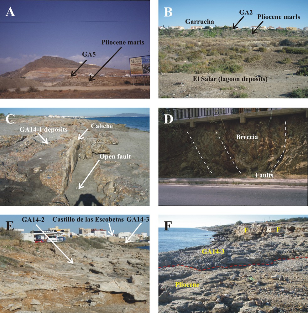
Selected pictures of the localities. A. GA5 during resort building on Pliocene marls. B. Eastwards view of the fault-controlled steeped western limit of the Garrucha village, at the top GA2 overlies Upper Pliocene sediments, whereas the ancient lagoon formed at the MIS 5e (El Salar) is at the foot. C. Open faults affecting GA14-1 carpeted by caliche. D. Pliocene deposits strongly brecciated due to the effect of satellite faults (La Gurulla fault) of the Palomares Fault. E. Northward Panoramic picture showing GA14-2 deposits at the front and GA14-3 at the back, just under the Castillo de las Escobetas. F. Coarse conglomerates with high amounts of Glycymeris shells (GA14-3), which lie unconformably over azoic fine-grained conglomerates and sandstones of Pliocene age. Caliche-carpeted fault plains (F) are marked. Masquer
Selected pictures of the localities. A. GA5 during resort building on Pliocene marls. B. Eastwards view of the fault-controlled steeped western limit of the Garrucha village, at the top GA2 overlies Upper Pliocene sediments, whereas the ancient lagoon formed at the MIS ... Lire la suite
As a result of intensive building and active tectonics, outcrops from the same deposit may appear at various elevations and, in this case, amino acid racemization (AAR) dating can be a very useful tool for age-stratigraphic correlation (Belluomini et al., 1986; Demarchi et al., 2015; Hearty, 1986, 1987; Hearty et al., 1986; Miller et al., 1986; Torres et al., 2000, 2006, 2010; Wehmiller, 1982). AAR was used here:
- • to establish a reliable chronological framework for the coastal deposits around the mouths of the Aguas and Antas rivers. For this purpose, we used shells from the bivalve Glycymeris, which are abundant in Mediterranean raised deposits;
- • the paleogeographical reconstruction was completed by comparison of AAR ages from the lagoonal deposits near the mouth of Antas River (Figs. 1B and 2B) drilled in 2009 for geotechnical purposes (SRA borehole);
- • in addition, we discuss the influence of tectonic activity, very important during the Quaternary, according to previous works (Booth-Rea et al., 2004; Martínez-Díaz and Hernández-Enrile, 2004; Silva et al., 2003; Stokes, 2008).
2 Geological setting
2.1 Tectonic framework
A series of studies have been devoted to the active tectonics-controlled evolution of the Neogene basins of the Betic realm (Mather, 1991; Sanz de Galdeano and Vera, 1992; Silva et al., 1993; Stokes, 1997; Stokes and Mather, 2003; Viseras, 1991). Adjacent to the study area, in the Huércal-Overa Basin (Fig. 1A), intense Plio-Pleistocene tectonic activity linked to faults has been described (García-Meléndez, 1993; García-Meléndez et al., 2003), which decreased during Middle Pleistocene times.
One of these basins with an intense tectonic control is the Vera Basin, where the study area is located. The Vera Basin developed within the Internal Zone of the Betic Cordillera (Sanz de Galdeano and Vera, 1992).
The basin infill consists of marls, siltstones, sandstones, and conglomerates of Miocene–Pliocene age. Völk and Rondeel (1964) established the first Pliocene–Pleistocene stratigraphy of the basin and an extensive review of the Vera Basin evolution was provided by Stokes (2008). During Pliocene–Early Pleistocene times, the basin was inverted (Stokes, 2008) and functioned as a continental basin, sedimentation being controlled by coalescent alluvial fans that fed a playa lake.
From a geodynamical point of view, the Vera Basin is placed along the eastern Betic Shear Zone (Silva et al., 1993) or the Trans-Alboran Shear Zone (De Larouzière et al., 1988), next to three important active faults (Fig. 1A): Carboneras Fault, Palomares Fault and Corredor de las Alpujarras Fault (Bousquet, 1979; Gràcia et al., 2006). The activity of these faults explains the current seismicity of the zone (Instituto Geográfico Nacional, 2001; Marín-Lechado et al., 2005; Masana et al., 2004), the Palomares Fault being responsible for the earthquake of 1518.
The Palomares Fault appeared to control the marine/terrestrial boundary, although Stokes (2008) indicates a lack of information in the present-day coastal line. According to Stokes (2008, p. 204), from the Pleistocene to the recent times, alluvial deposits have dominated, and near the Antas River's mouth the terrace levels have become fragmentary. Thus, along the Carboneras Fault zone, 5–10 m of vertical offset across Tyrrhenian age marine deposits are common (Bell et al., 1997). During the last 100 ka, vertical slip rates of 0.05–0.1 mm/yr have been estimated for this fault.
In addition, a number of studies have focused on determining the drainage network development and incision rates (Schulte et al., 2008). The offshore geomorphology reveals that at present the Vera Basin extends eastwards underwater, marking a very narrow continental talus connecting to deeper sea zones through a deeply incised stepped talus (Díaz del Río Español and Fernández Salas, 2005; Rey and Díaz del Río, 1983; Sanz Alonso et al., 2002).
2.2 Local geology
The study zone is located between Cabrera Sierra to the south and Almagrera Sierra to the north, both made of dolostones and schists (Fig. 1A). The area can be divided into two well-differentiated zones: inland and coastal sensu stricto.
2.2.1 Inland
This zone consists of a flat plain made of black mud with patches caused by salt (mostly gypsum) efflorescence development and a thriving halophylous plant carpet. This zone floods during heavy storms because of the poor drainage capacity of the Antas River (El Salar, Figs. 1B and 2A). The depression is closed to the south by dolostones and schists of the Nevado-Filabride complex of Triassic age (Marín Vivaldi et al., 1973). To the west there are smoothed hummocks developed in marls and sands of Pliocene age. To the north, the depression boundary consists of low hills formed by Pliocene sediments and volcanic rocks of Cenozoic age. The southern border is characterized by the stepped-back of the Garrucha village (conglomerates, sands and marls of Pliocene age capped by Pleistocene raised coastal deposits) (Fig. 2B). An isolated mesa (Cabezo La Pella), also capped by Pleistocene raised marine deposits, marks the north boundary of the studied area (GA16 – see Fig. 1B).
2.2.2 Coastal fringe
Many staircase coarse-grained marine terraces outcrop at several elevations (Fig. 1B, Table 1 in Supplementary information). This zone spans from the mouth of the Aguas River to the south, an ephemeral stream that during the dry season (most of the year) shows a dry perimeter, to a small brackish water body (lagoon) seaward, which is closed by a wave-generated bar. During flashflood periods, the bar is eroded and large amounts of clastic sediments and drifted plant debris reach the sea.
Near the Aguas River's mouth, a paleocliff-abrasion platform and two raised beach deposits (GA5), now destroyed as a result of the construction of a resort, attest to the ancient position of the shoreline. The present-day beach between the Aguas River and the Castillo de las Escobetas area lies on strongly cemented Persististrombus latus and Glycymeris bearing conglomerates and sandstones (GA14-1). It is important to mention that in the past, P. latus was usually referred to as Strombus bubonius Lamarck 1822, although Strombus latus Gmelin 1791 is the senior synonym. However, according to the recent taxonomic revisions of Strombus species undertaken by Kronenberg and Lee (2007) and Harzhauser and Kronenberg (2008), this gastropod belongs to the genus Persististrombus.
These P. latus-bearing deposits reappear north of the Antas River's mouth as a conglomerate strip of 13 m above sea level at its top (GA15).
The Castillo (castle) de las Escobetas was built on a retreating cliff developed on raised coastal deposits of Pleistocene (GA14-2, GA14-3) and Pliocene age. The village of Garrucha lies on a series of staircase marine deposits at different elevations (GA2 in the upper part and GA17, GA21 at the foot).
Northwards of Garrucha, there is another flat depression made of lagoonal fine-grained sediments, close to the Antas River's banks near its mouth, in which the SRA borehole was drilled (Fig. 1B).
North of the Antas River's mouth, sewage trenches allowed the observation of sub-recent shell beds (GA18, GA19). The study area ends in the deposits 29 m above sea level that belong to the Cabezo de la Pella hill (GA16).
North of the Antas river thalweg, long and wide Holocene sandy beach deposits develop in front of the raised Pleistocene deposits of Puerto Rey resort (GA5) that rest on the slope of the Cabezo de la Pella hill. Recent erosion affected a part of the Pleistocene raised marine deposits at Puerto Rey.
Overall, geographical and physiographical data show that the raised coastal deposits in the area are very dissimilar from the long and continuous sand and gravel stripes described in other parts of the Mediterranean coast (Bordoni and Valensine, 1998) or elsewhere (Murray-Wallace, 1995; Murray-Wallace et al., 1998). They are discontinuous outcrops, their discontinuities being due to active tectonics, building, and erosion.
3 Material and methods
3.1 Sampling
Sampling was focused on the marine raised beach deposits along the coast around the Aguas and Antas Rivers’ mouths and adjacent areas (Fig. 1B, Table 1 in Supplementary information). Every effort was made to recover deep samples (50 cm to 1.5 m) in order to avoid surface contamination and to minimize the influence of air temperature. In fact, burial depth has been shown to affect the extent of racemization/epimerization (Torres et al., 2000; Wehmiller, 1977, 1982). Sampling was facilitated because of the presence of the trenches dug for building foundations. Surprisingly, the coarse sands and gravel were loosely cemented or non-cemented, thus allowing samples to be hand-picked. When this was not possible, samples from strongly cemented conglomerate beds were recovered after previous removal of the superficial crust. In this case, samples were extracted with a hammer and a chisel (GA5, GA14-1, GA14-2, GA14-3).
Only Glycymeris sp. shells were recovered, which are present in all raised beach deposits in the Mediterranean realm, with rare exceptions (cf. Hearty, 1986, 1987; Hearty et al., 1986; Torres et al., 2010). The number of Glycymeris samples from each locality is shown in Table 2 in Supplementary information, although some isoleucine epimerization values of some localities had been obtained previously (Torres et al., 2000, 2010). For AAR, a hollow diamond drill was used to remove a discoid sample (8 mm in diameter) from an area close to the beak of the shells to reduce variability, as Hearty et al. (1986) observed variations of 30% in d-aIle/l-Ile values from different parts of Glycymeris shells. Given the chalky appearance of some old samples, the outermost and innermost parts of the core were rejected in order to avoid the zones most prone to contamination. In some cases, the outer and inner shell layers, with distinct aragonite crystal arrangements, spontaneously cleaved. However, peripheral parts with visible weathering, approximately 20–30%, were removed after chemical etching with 2N HCl. Afterwards, 10–20 mg of sample was taken.
3.2 AAR analysis
Amino acid concentrations and ratios were quantified using RP-HPLC, following the sample preparation protocol described by Kaufman and Manley (1998) and Kaufman (2000). This procedure involves sample hydrolysis, which was performed under an N2 atmosphere in 20 μL/mg 7M HCl for 20 h at 100 °C. The hydrolysates were evaporated to dryness in vacuo, and then rehydrated in 10 μL/mg 0.01M HCl with 1.5 mM sodium azide and 0.03 mM l-homo-arginine (internal standard). Samples were injected in an Agilent-1100 HPLC, equipped with a fluorescence detector. Excitation and emission wavelengths were programmed at 335 nm and 445, respectively. A Hypersil BDS C18 reverse-phase column (5 μm; 250 × 4 mm i.d.) was used for the analysis.
Derivatization took place before injection by mixing the sample (2 μL) with the pre-column derivatization reagent (2.2 μL), which comprised 260 mM isobutyryl-l-cysteine (chiral thiol) and 170 mM o-phthaldialdehyde, dissolved in 1.0 M potassium borate buffer solution at pH 10.4. Eluent A consisted of 23 mM sodium acetate with 1.5 mM sodium azide and 1.3 microM EDTA, adjusted to pH 6.00 with 10 M sodium hydroxide and 10% acetic acid. Eluent B was HPLC-grade methanol and eluent C consisted of HPLC-grade acetonitrile. A linear gradient was performed at 1.0 mL/min and 25 °C, from 95% eluent A and 5% eluent B upon injection to 76.6% eluent A, 23% eluent B, and 0.4% eluent C at min 31.
Although more than one amino acid is generally used for AAR dating, isoleucine epimerization values (d-aIle/l-Ile) in Glycymeris shells were chosen for the relative dating of the raised marine deposits because these values better discriminate between sites than those of glutamic acid and aspartic acid (Torres et al., 2000, 2013). In fact, isoleucine epimerization values have been widely used alone for dating Mediterranean raised deposits (Belluomini et al., 1986; Hearty, 1986, 1987; Hearty et al., 1986), and according to Goodfriend (1991), pag 293: “… analysis of more than one amino acid provides largely redundant information on sample age.”
To identify outliers produced by inter-shell variations and taphonomical processes (Torres et al., 2013) and to reduce standard deviation, several samples were analyzed from each locality.
For the isolation of amino acids from the intracrystalline protein fraction, a bleaching pre-treatment in NaOCl is usually performed, with the purpose of obtaining more robust results. However, we did not apply this pre-treatment because this fraction in Glycymeris shells—which includes the 70% of total amino acids—does not behave as a closed system (Demarchi et al., 2015).
In the localities studied here, 26 analytical samples from a total of 191 (13.6% of the data—1 in GA2, 2 in GA21, 5 in GA14-1, 1 in GA14-2, 8 in GA14-3, 3 in GA15, 2 in GA16, 2 in GA5-1, and 2 in GA5-2) were excluded because of their high content of l-serine with respect to l-aspartic acid, which indicates contamination by modern amino acids (cf. Kaufman, 2006) or due to abnormally high d-aIle/l-Ile values, falling outside the 2σ range of the group (cf. Hearty et al., 2004; Kosnik and Kaufman, 2008). Each result and the samples rejected are shown in the Appendix. The data used in the following sections is only from the screened samples, not including outliers.
The number of Glycymeris samples from each locality excluding outliers is shown in Table 2 in Supplementary information, although some isoleucine epimerization values of Glycymeris in certain localities were obtained previously by gas chromatography (Ortiz et al., 2004; Torres et al., 2000, 2010 – see Appendix). The values obtained by RP-HPLC required transformation in order to be compared with d-aIle/l-Ile values measured by GC (cf. Ortiz et al., 2004). This transformation was based on the analysis of samples from an ILC exercise (cf. Torres et al., 1997; Wehmiller, 1984; Wehmiller et al., 2010). The isoleucine epimerization (d-aIle/l-Ile) values ranging between 0.45 and 1.1 by IE-LC and RP-HPLC were approximately lower by 0.10 than those obtained by GC, i.e. d-aIle/l-IleGC = d-aIle/l-IleHPLC-IE-LC + 0.10. For lower d-aIle/l-Ile values, the difference was between 0 and 0.05.
4 Results
We studied several discontinuous outcrops located between the Aguas and Antas river mouths, in the Palomares Fault area (Fig. 1B, Table 1 – Supplementary information), the characteristics of which are described in Section 4.1. To complement this study, we also examined the record of a borehole drilled in lagoonal deposits near the mouth of the Antas River (SRA). The amino acid epimerization values of each locality and their relationship with MIS and Aminozones established in Hearty et al. (1986) for the Mediterranean realm are described in Section 4.2.
4.1 Stratigraphy
La Marina (GA5) (Fig. 2A), which has been destroyed as a result of the construction of resorts and of a golf course, consists of a complex system of coastal forms. At the top, there is an abrasion platform carved on dolostones where it was possible to observe scattered gravel and sand clasts strongly cemented by iron oxides and carbonates. No fossil shells were found. There are two downslope staircase marine terraces. The uppermost (GA5-1) consisted of three sets of strongly cemented gravel capped by calcrete, with a total thickness of 1.5 m in which Glycymeris shells were badly broken. A lower terrace step (GA5-2) 1 m down slope of the uppermost beds (GA5-1) showed two thick conglomerate sets, totaling 1.2 m of thickness. Broken Glycymeris shells and Pecten sp. shells were observed.
The lower level of Castillo de las Escobetas deposits (GA14-1) (Fig. 2C) are strongly wave abraded, being locally sand-covered as a result of beach-feeding operations. There are large amounts of detached boulders of conglomerates and abundant Glycymeris sp. shells and scarce P. latus representatives in the abraded beach rock and boulders. This terrace is strongly deformed, showing abundant open fractures (Fig. 2C). This terrace is strongly deformed showing abundant open fractures (sometimes with caliche-coated walls), most of them oriented north–south, showing carbonate infill. The largest visible fault appears in a roadcut (Fig. 2D).
The intermediate level of Castillo de las Escobetas (GA14-2) consists of a coarse conglomerate with abundant Glycymeris sp shells (Fig. 2E). This locality is barely observable because of collapses.
The upper level of Castillo de las Escobetas site (GA14-3), which is 1.5-m thick and makes the foundation of the Castillo de las Escobetas building (Fig. 2F), consists of strongly carbonate-cemented coarse gravels that include enormous boulders from the underlying formation made of finer gravel and very coarse sand of Pliocene age. Only Glycymeris representatives are visible, these arranged in two shell beds. At the top of the outcrop, shells are less cemented and the whole rock is rubefacted and caliche-capped. This outcrop is affected by active tectonics (Fig. 2F), showing collapses and open normal faults with caliche-encrusted sides.
The Garrucha Sea Promenade section (GA17) comes from a foundation trench excavated in the sea promenade of the Garrucha village (Fig. 1A – Supplementary information). The preserved section comprises 1.5-m-thick gravels dipping offshore at the bottom, and caliche- and red soil-capped sands at its top. No shell beds are present, but scattered Glycymeris sp. representatives and a small P. latus shell fragment were detected. The Pleistocene record lies unconformably on yellow silts from the Upper Pliocene.
The La Gurulla site (GA2) was visible in the walls of a deep foundation trench (Fig. 1B in Supplementary information) showing 2.0-m-thick beach deposits dipping offshore. These are made of loosely cemented gravels and coarse sands with abundant scattered Glycymeris sp. shells. The top of the record appears rubefacted and caliche bands are visible. The Pleistocene deposits lie unconformably on offshore dipping gravels and sands of Upper Pleistocene age that are foresets of the typical Gilbert delta that mark the end of the marine infill of many marginal basins in the Betic domain (Aguirre, 1998).
The Pedro Gea square deposits (GA21) could be observed because a wide area was stripped in order to remodel an ancient square (Fig. 1C in Supplementary information). Excellent exposures revealed 1.2-m-thick loosely cemented gravel deposits dipping offshore. There are abundant Glycymeris sp. shells and no other mollusk species were found. These deposits lie unconformably on yellow silts from the Upper Pliocene.
The Puerto Rey Resort deposits (GA15) are arranged in a narrow rocky stripe running parallel to the present-day coast (Fig. 1D–E in Supplementary information). This stripe represents an ancient barrier system in which only beds dipping offshore are discernible, although back-barrier deposits are observed in some points. Scattered Glycymeris sp. shells are visible as well as some rare P. latus representatives.
The Puerto Rey backbeach deposits (GA19) present abundant G. insubrica representatives. These were recovered on the surface of the back beach zone where wave reworking is unusual and shells are more in the Aeolian dominion than in the marine one (Fig. 1F in Supplementary information). In our view, the shells were transported to their present-day position during abnormally energetic storms or human action.
Puerto Rey beach deposits (GA18) consist of a thin sandy bed that crops out at the bottom of a drainage trench. G. glycymeris and G. insubrica shells accumulate in a gravelly interbed some centimeters thick. This beach complex was covered by recent alluvial sediments more than 1 m thick. Some shells have been 14C dated at 5,080 ± 220 cal yr (Ortiz et al., 2004).
The marine deposits of Cabezo de la Pella (GA16) appeared capping a low hill near the water line. These deposits were destroyed by the construction of an aquatic park on top. The marine deposits covered an abrasion platform developed on Upper Pliocene yellow silts. Gravels are largely dominant and two boulder-sized interbeds are observable. The sequence coarsens upwards, being capped by caliche and strongly cemented. Large Pecten cf. jacobaeus are visible, together with Glycymeris sp. shells.
The SRA borehole was drilled on the right margin of the Antas River, near its mouth, in which five units (Fig. 3) can be identified: Unit I (29.7 m–28.2 m) consists of Pliocene yellow–grey marls and silts; Unit II (28.2 m–24.2 m) made of loosely cemented gravel with sandy interbeds, and Unit III (24.2 m–18.2 m), with massive finely grained sands, are ascribed to MIS 11; Unit IV (18.2 m to 3.0 m) consists of variegated lutites, with bioclasts and abundant gypsum crystals, and belongs to the end of MIS 6 and MIS 5; the uppermost 3 m (Unit V) are made of laminated fine-grained sands of probably MIS 1 age. Ages were obtained through aspartic acid and glutamic acid d/l values measured in ostracodes (Cyprideis torosa). In order to interpret the occurrence of active tectonics during the Pleistocene, these ages were compared with the aminostratigraphy of raised beach deposits established from d-aIle/l-Ile values in Glycymeris shells.
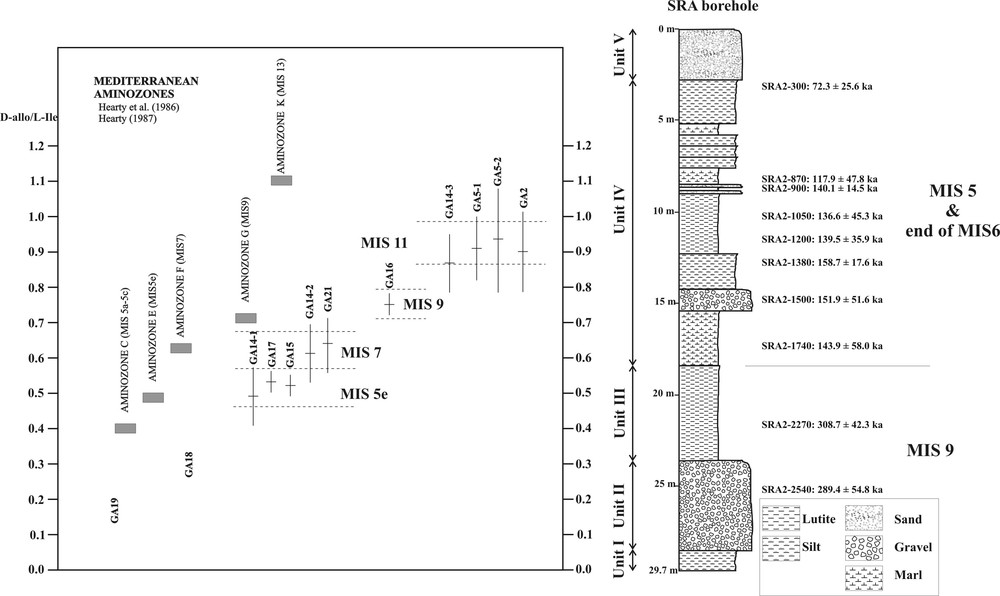
Aminostratigraphy of the raised marine deposits based on d-aIle/l-Ile values compared with the mean values for the Aminozones defined in Hearty et al. (1986) and Hearty (1987) and their corresponding MIS. The chronostratigraphy of the SRA borehole is also shown.
4.2 Amino acid epimerization
The use of AAR allowed a general perspective of the Pleistocene shorelines in the Mediterranean basin. The Ile epimerization ratios obtained for the shells from the raised marine deposits of Garrucha are shown in Table 2 – Supplementary information. They are arranged according to their relative d-aIle/l-Ile ratios on Fig. 3 and ascribed to the Marine Isotope Stages (MIS) on the basis of the mean d-aIle/l-Ile ratios for these stages in the Mediterranean realm (Hearty et al., 1986; Hearty, 1987; Torres et al., 2000, 2010). In fact, GA15 and GA14-1 were assigned to MIS 5e (Torres et al., 2010) and GA18 to MIS 1 (Ortiz et al., 2004). For comparison, the ages obtained in the SRA borehole are also shown on Fig. 3.
Of note, the dating method isoleucine epimerization is useful to discriminate sites at the level of MIS, but the high standard deviation values are related to the taphonomy of these deposits (they are time-averaged) and diagenesis (Torres et al., 2013): the standard deviation was higher in samples from shallow depths, thereby hindering discrimination between MIS substages. Furthermore, amino acids from the intracrystalline fraction of Glycymeris shells from the same locality show high standard deviation values, thereby indicating that they do not behave as a closed system (Demarchi et al., 2015).
In general, there was a good correspondence between the extent of Ile epimerization found in the shells from the staircase marine deposits and their elevation (with the exception of GA16 and GA14-3) (Fig. 1B): the highest raised marine beds (GA2, GA5) were the oldest, as reported in other wide series of dated localities along the Spanish Mediterranean coast (cf. Hearty, 1986, 1987; Hearty et al., 1986; Torres et al., 2000). It was also observed that marine deposits piled-up during odd MIS when highstand sea level occurred. GA18 (0.8 m) and GA19 (2.0 m) were of Holocene age (Fig. 1B) and represented deposits of the prehistoric and historic shorelines.
5 Discussion
The uppermost deposits of La Marina (GA5-1, GA5-2) and La Gurulla (GA2) showed similar average isoleucine epimerization ratios (Table 2 in Supplementary information), being slightly (differences of 0.02 to 0.05 in mean d-aIle/l-Ile values) lower in the upper level of Castillo de las Escobetas (GA14-3). On the basis of their isoleucine epimerization values, these deposits were placed at MIS 11 (Fig. 3), although they might overlap with MIS 9 (1 of 7 samples in GA5-1, 6 of 33 samples in GA2, 11 of 44 samples in GA14-3).
The intermediate level of Castillo de las Escobetas (GA14-2, 3.0 m) and the Pedro Gea square (GA21, 4.0 m) belonged to MIS 7 (Aminozone F of Hearty et al., 1986; Fig. 1B), whereas the lower level of Castillo de las Escobetas (GA14-1, 0.5 m), the Garrucha Sea Promenade (GA17, 4.0 m) and Puerto Rey (GA15, 7.0 m) were deposited during MIS 5e (Aminozone E of Hearty et al., 1986; Fig. 1B).
Of note, the mean d-aIle/l-Ile values of GA14-2 and GA21 fell within MIS 7 (Aminozone F of Hearty et al., 1986), but the variability was such that they might also belong to MIS 5 (Aminozone E). However, of note, only three samples of a total of 10 in GA14-2 and 1 sample of a total of 6 in GA21 showed low d-aIle/l-Ile values, typical of the Aminozone E. Moreover, representatives of P. latus, traditionally considered a marker of the Tyrrhenian stage (MIS 5e) (Cuerda, 1987), were absent in these localities. In contrast, MIS 5 localities (GA15, GA14-1, GA17) contained P. latus shells, which have also been reported in many sites belonging to this stage, not only along the Iberian Mediterranean coast (Dabrio et al., 2011; Goy et al., 2006; Hearty et al., 1986; Torres et al., 2000, 2010) and Mallorca (Hearty, 1987; Torres et al., 2010), but also in Italy (Belluomini and Delitala, 1988; Belluomini et al., 1986, 1993; Hearty, 1986; Hearty et al., 1986), Morocco (Brückner, 1986; Hearty, 1986), and Tunisia (Hearty, 1986; Miller et al., 1986). However, P. latus was also observed in certain Mediterranean MIS 7 deposits (Torres et al., 2010; Zazo, 1999; Zazo et al., 2003). On the whole, GA14-2 and GA21 could be assigned to MIS 7.
These sources of uncertainty can be explained because, according to Murray-Wallace (1995) and previous studies on Glycymeris shells (Demarchi et al., 2015; Hearty et al., 1986; Torres et al., 2013), a series of errors can accumulate in the measured d/l values since dating raised beach deposits is complex, at least with regard to individual MIS substages. Demarchi et al. (2015) observed that even the intracrystalline fraction of proteins in Glycymeris shells is prone to decomposition. Furthermore, differential diagenesis, burial depth, and time averaging, among other factors (Torres et al., 2013), produce high standard deviations in d/l values. Moreover, Glycymeris shells have a complex microstructure, the extent of racemization/epimerization differing by as much as 30% in different sections of the shell (Hearty et al., 1986; Torres et al., 2013). The inner layer at the apex of the shell is proposed as the optimal sampling position for AAR analyses.
Thus, although Glycymeris shells are probably not the best material for AAR dating purposes, they are ubiquitous—with rare exceptions—in the Quaternary western Mediterranean raised beach deposits, where representatives of other bivalves are uncommon, with the exception of Arca noae, which is associated with rocky bottoms. Therefore, Glycymeris shells are generally the only material in the western Mediterranean realm with which it is possible to conduct dating studies, at least for MIS (Torres et al., 2013). However, Pierini et al. (2016) satisfactorily used Pecten shells for dating raised deposits on the Greek coastline.
The oldest raised beach deposits (MIS 11) maintained a similar elevation along the paleo-coast from La Marina (GA5, 20.0 m), where they overlie rocks from the Nevado Filábride complex (Sierra Filabres), until its northern tip in La Gurulla (GA2, 24.0 m), where they lie unconformably on Upper Pliocene sediments. However, GA14-3 is located at 6.0 m a.s.l., attesting to the influence of active tectonics. Therefore, the Palomares Fault was active after MIS 11.
Other evidences of recent tectonic activity are related to the beach deposits of Cabezo de la Pella (GA16) which were assigned to MIS 9 (Aminozone G of Hearty et al., 1986; Fig. 3). These raised beach deposits (GA16) can be correlated with the lower part of the SRA record (Units II and III), placed ca. 10 m b.s.l (Fig. 3), on the basis of AAR dates. The paleogeographical scenario can be interpreted as marine deposits in a protected bay and might be what remains of the former marine Vera Basin defined in Stokes (2008). The present-day differences in elevation between GA16 and MIS 9-assigned deposits of SRA borehole were probably related to local tectonic uplift, i.e. the Cabezo de la Pella hill (Fig. 1B) would have played an important role in the geomorphological evolution of the area, as reflected in the absence of MIS 7-dated sediments in the SRA record. This interpretation implies intense activity of the Palomares Fault, which would also explain the singular morphology of the La Gurulla hill, characterized by a straight and vertical talus. Therefore, the Palomares Fault was being responsible for a total vertical slip of ca. 35 m. This activity means an average rate of ca. 35 m/300 ka, which is in agreement with Bell et al. (1997), who calculated a vertical slip rate of 100 mm/ka for the Carboneras Fault during the last 100 ka, and with Silva et al. (2003), who calculated a differential uplift of 100–80 mm/ka.
The intermediate level of Castillo de las Escobetas (GA14-2, 3.0 m) and the Pedro Gea square (GA21, 4.0 m) would correspond to the highstand sea level of MIS 7. These deposits are deformed (Torres et al., 2000), but the fault trace is difficult to map because the area is covered with buildings. The geomorphological position of these deposits is consistent with the age of the Antas river incision in Alfaix (Fig. 1A), when the building up of tufa deposits started during MIS 7 (Stokes, 2008). The highstand sea level that occurred during MIS 7 also produced several marine deposits along the Spanish Mediterranean coast (Goy et al., 2006; Hearty, 1987; Torres et al., 2010; Zazo et al., 2003), including some in Roquetas de Mar, Pozo del Esparto, and La Marina-Santa Pola (Fig. 1A). Marine terraces of this age are also found in Morocco (Brückner, 1986) and Italy (Belluomini et al., 1986, 1993; Hearty et al., 1986).
Deposits belonging to MIS 5 comprised distinct morphological units: between the Aguas River's mouth and the northern tip of the Garrucha village (including the localities GA14-1, 0.5 m, and GA17, 4.0 m), active tectonics strongly affected these deposits, which are clearly visible as open faults with caliche-coated separated walls (Fig. 2C). Almost all the Garrucha Sea Promenade (GA17) was developed on this terrace and underwater in the port area (1 m below the sea level) there is an undated terrace, which could belong to a MIS 5 substage, as also occurs in the Cabo de Huertas zone (Torres et al., 2000)—Fig. 1A.
Between the Antas River's mouth and the Cabezo de la Pella hill, the raised beach deposits assigned to MIS 5e (with P. latus) are at a higher elevation (GA15) and appear as a bar with its top 11 m a.s.l (Figs. 1 and 2A), closing the Antas River's mouth and thus creating a lagoon whose coeval deposits identified in the SRA record are 2.5 m b.s.l. (Unit IV – Fig. 3), attesting to moderate subsidence.
Similarly, in the coastal area to the south of the province of Alicante (Santa Pola – Fig. 1A), a neotectonic event produced alternating uplifted areas constituted by marine terraces and subsiding zones, which host lagoons (e.g., Santa Pola Lagoon) separated from the open sea by beach barriers, at least since Middle Pleistocene times (Dabrio et al., 2011). In the nearby Pego-Oliva Basin (Alicante), a lagoon also developed (Torres et al., 2014). According to Schulte et al. (2008), large-scale tectonics triggered a general down-cutting trend, whereas the main aggradation and incision phases occurred during periods of major changes in sea level. In fact, according to Booth-Rea et al. (2004) and Martínez-Díaz and Hernández-Enrile (2004), the existence of extensional tectonics linked to the Carboneras Fault seems to be responsible for continuous and regional tilting processes, which transformed a pre-existing morphology, creating new Neogene and Quaternary basins in the area and smaller tilted blocks, like in the Garrucha area.
GA18 and GA19 represent Holocene age deposits, thereby demonstrating a retreat of the shoreline during the Upper Holocene.
6 Conclusions
Amino acid epimerization analysis is a powerful tool for deciphering the geomorphological evolution in coastal areas, especially in regions influenced by marked active tectonics. However, although intra-shell and inter-shell variations in Glycymeris shells caused by differential diagenesis, time averaging, and other factors can produce significant variability in d-aIle/l-Ile values, this material proved useful to discriminate sites at the level of MIS.
In the Garrucha area, five staircase raised beach deposits were described. Together with our examination of the lagoonal deposits of SRA borehole, these studies allowed us to infer that active tectonics of the Palomares Fault affected the Vera Basin during Middle and Upper Pleistocene times. In fact, Quaternary deformation also affected many Neogene Mediterranean satellite basins.
The largest deformation of the Palomares Fault, with a vertical slip on its eastern side, was dated after MIS 11, affecting deposits that now are capping the top of the Cerro Largo hill, where the Garrucha village is built. In contrast, the western side of the fault was not so active.
To a lesser extent, the satellite faults of the Palomares Fault remained active after MIS 5, affecting MIS 11 deposits that were in part lowered, and MIS 7 deposits that were strongly fractured in such a way that only AAR analyses of samples from collapsed blocks allowed recognizing their presence. MIS 5 marine deposits were also faulted and tilted northwards, being presumably below sea level in the village's port area.
Acknowledgements
Funding was obtained through the projects “Paleoclimatological revision of climate evolution in Western Mediterranean region” (European Union, CE-FI2W-CT91-0075) and “Paleohidrogeological Data Analysis and Model Testing” (European Union, FIKW-CT-2001-00129). The Biomolecular Stratigraphy Laboratory has been partially funded by ENRESA. We thank Beatrice Demarchi and Pedro Alfaro for their helpful comments on the manuscript.