

1 Introduction
The Armorican Massif's post-Variscan geological evolution is known only from scattered small Cenozoic basins, and it is commonly admitted that, from the Carboniferous to the Eocene, the Massif merely underwent erosion then weathering (e.g., Sissingh, 2006). Divergent, but notable, studies have indicated the possibility of Mesozoic deposits on the Massif during periods when it would have been partly or largely underwater (Andreieff and Lefort, 1972; Guillocheau et al., 2003; Wyns, 1991; Wyns et al., 2003). Evidence for Cretaceous reworking is plentiful (see Bessin et al., 2015 for a review), with the nearest in situ deposits being Cenomanian sands in the Laval Basin (Durand et al., 1973). The Rennes Basin, as the deepest Cenozoic basin of the Armorican Massif (Wyns, 1991), is a good candidate for tracking possible preserved pre-Eocene (Mesozoic) series. A 5-km seismic line across the basin from the 2000 GeoFrance 3D programme (Wyns et al., 2002; Fig. 1) reveals three seismic units interpreted as preserved Middle Jurassic and Upper Cretaceous series under the outcropping Cenozoic cover (Wyns et al., 2002). Without any drilling data, this interpretation has remained hypothetical.
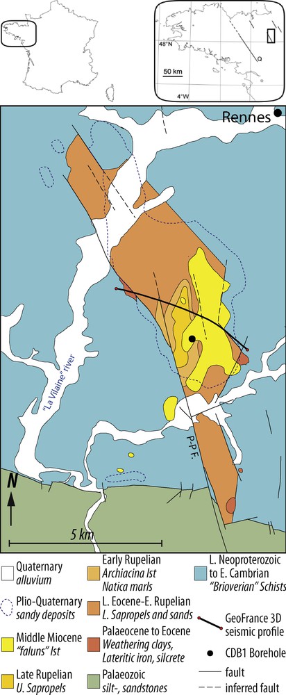
Geological map of the Rennes Basin showing the location of Borehole CDB1 and the GeoFrance 3D seismic profile. P-P F.: Pont-Péan Fault.
Finally, along with water-resource and geothermal-potential prospecting, the CINERGY Project drilling programme was funded to resolve this question (Bauer et al., 2010). Borehole CDB1 was completed in 2010 at a depth of 675.05 m. The first results and implications of the borehole stratigraphy, including both the basin's sedimentary infill and its basement, are presented below.
2 Geological setting of the Cenozoic Rennes Basin
The small north–south Rennes Basin (15 km long, 2 km wide) is bounded to the west by the dextral N160° Pont-Péan Fault and to the east by hidden N135° to N160° en echelon faults relayed by subsequent N20° faults (Fig. 1). Its overall shape is known from a gravimetric survey that reveals an elongate basin partitioned by numerous faults into blocks with very different sedimentary thicknesses (Trautmann et al., 1994; Wyns et al., 2002) and with its deepest part centred on the Chartres-de-Bretagne area (Jaeger and Corpel, 1967). The basin is largely surrounded by a Brioverian Group (Gp) basement of folded Late Neoproterozoic to Early Cambrian azoic siltstone and sandstone, and rests on Palaeozoic synclines to the south. Six lithostratigraphic formations, ranging in age from Late Eocene (Lower Sapropels Fm.) to Pliocene (Azoic Sands Fm.), were previously defined through integrating outcrop and shallow-borehole data (e.g., Durand, 1960; Estéoule-Choux, 1967; Ollivier-Pierre, 1980; Thomas, 1999; Trautmann et al., 1994, 2000; Fig. 1). Two major unconformities were also identified:
- • a first angular and erosional one between the Upper Sapropels Fm. (Late Rupelian) and the Faluns and Lithothamniids Limestone Fm. (Langhian to Serravallian);
- • a second purely erosional one, which underlies the Azoic Sands Fm.
Attempts to estimate the thickness of each formation have been in vain due to their high variability in outcrop (Trautmann et al., 1994).
Finally, the Chartres-de-Bretagne area was selected as the best location for a deep borehole to intersect the entire basin infill.
3 Material and methods
3.1 Borehole CDB1
The first 66 m of the Borehole CDB1 (hereinafter CDB1) were rotary drilled with cuttings being collected every 3 m then, from 66 to 675.05 m, the drilling was fully cored in HQ diameter (cores of 85 mm diameter). Core analysis comprised a detailed sedimentological description at the 1:20 scale, colour description (Munsell Charts) and full 360° core scanning on a DMT Corescan®. Sampling was performed on half cores split into two and placed in nitrogen-filled plastic bags.
3.2 Biostratigraphy
The entire borehole series was sampled at 105 levels for micropalaeontological (0–80 and 645–675 m in depth) and palynological (0–675 m in depth) analysis (Fig. 2). Although pollen grains provide the first clues for palaeoenvironmental and climatic reconstruction, some palynomorph assemblages or species are fairly good stratigraphic biomarkers where dinocysts are absent. Sample preparation followed standard protocol for palynology in terms of acid attack, washing, sieving, and mounting, and for micropalaeontology in terms of soft drying, water soaking, and 50 to 200 μm sieving.

Litho- and chronostratigraphy of Borehole CDB1. Depositional environments: 1: fluvial; 2: palustrine to lacustrine; 3: lagoon to restricted marine; 4: coastal marine to open marine.
4 Results
4.1 Lithostratigraphy, facies and palaeoenvironments
4.1.1 The Brioverian Gp. basement and its weathering profile
The Brioverian basement underlying the Rennes Basin consists mostly of folded (dip varies from 50° to 90°) shale and siltstone of distal turbidites (probably deposited in a prodelta environment; Trautmann et al., 2000) sedimentary facies (Fig. 2).
The basement is also marked by a deep weathering profile (Fig. 2), from which the topmost ferricrust and most of the upper (non-isovolumetric) saprolite (alloterite) were eroded by the overlying Cenozoic deposits; remnants of the saprolite, i.e. massive soft beige clays, occur from 404.92 to 405.90 m. Below 405.90 m, basement structures (stratification and cleavage) are preserved within an isovolumetric saprolite and beige clays change to grey towards 406.60 m. Between 420 and 440 m, saprolite gradually turns to an underlying fissured layer (indurated but fractured rock; Wyns et al., 2004) with small quartz-, carbonates- or goethite/pyrite-filled fractures with rare short argillized intervals. The fractured horizon progressively passes to the fresh rock at ca. 520 m in depth.
4.1.2 The Chartres-de-Bretagne Fm.
The sedimentary succession of the Rennes Basin begins with a 30-m-thick formation (404.92–375.40 m) termed the Chartres-de-Bretagne Fm. (Fig. 2). It starts with a thin conglomeratic sole overlain by shaly deposits, including some organic-rich levels. The shale is massive (claystone) from 400.00 to 391.80 m, and it becomes thinly laminated up to ca. 386.00 m. The shale progressively returns to massive up to 380.80 m, with a sandier fraction appearing at 382.00 m. The uppermost part of this formation is made up of loose to poorly cemented quartzitic sandstone.
The deposits of the Chartres-de-Bretagne Fm. reflect various environments. The lowermost two metres are a transgressive lag, followed by coastal sand with benthic fauna (C. parisiensis, C. columnatortilis, A. kerfornei, V. globularis) attesting to temperate to warm marine waters. The first organic level, followed by a clayey interval up to 382 m, contains pollen assemblages prevailing in lacustrine and palustrine environments surrounded by subtropical forest with dominant Myricaceae and rare or absent herbaceous plants. The upper sandy interval, up to 375 m, is typical of a coastal environment with bivalves and benthic foraminifera. Nearby mangroves are indicated by Avicennia pollen grains and some brackish water dinocysts occurrences.
4.1.3 The Lower Sapropels Fm.
The Lower Sapropels Fm., whose contact with the underlying Chartres-de-Bretagne Fm. is marked by the disappearance of the sand fraction at 375.40 m (Fig. 2), is the thickest succession crossed by the borehole (375.40–85.15 m) and includes the Mohria Shales Fm. formerly described by Durand (1960). The entire succession exhibits pluri- to decametric alternations of laminated shale and massive or brecciated claystone, similar to that described in the Chartres-de-Bretagne Fm. The organic content of these deposits varies from zero (whitish claystone) to more than 10% (carbonaceous shale), but independently of laminated or massive facies. The laminated shale is pale ochre to dark brown-blackish in colour (depending on the organic content) with laminae from less than a millimetre to a few millimetres thick. Microfaults and soft sediment deformation, such as micro-slumping, are observed in places. The massive and brecciated claystone has various colours (whitish, ochrous, greenish, and brownish to blackish) depending on the organic content and the redox conditions. Where purely massive, the claystone is blocky textured and commonly associated with root traces. The brecciated facies is mostly in situ breccia resulting from pedoturbation/desiccation, but rounded muddy intraclasts attesting to episodic flows are also reported.
Both the claystone and shale are sulphide-rich with disseminated silt-sized pyrite grains or pyritized roots, plus bioturbations or fracture fillings. The only carbonate occurrences within the two facies are made up of:
- • rare centimetric mudclasts found basically in the laminated facies;
- • rare calcitic/ankeritic (epigenized) ostracod valves and gastropods (associated with organic layers);
- • a single pedogenic nodule found at 308.80 m.
The only limestone bed in this shaly succession is an unexpected massive 70-cm-thick calcrete (158.80–159.50 m).
The entire Lower Sapropels Fm. deposited in a lacustrine/palustrine environment, with the laminated shale corresponding to hypoxic lacustrine deposits (highly organic, no bioturbation) and the massive, blocky and pedoturbated clay corresponding to hydromorphic palustrine deposits.
The massive clay contains abundant plant tissue ranging from sub-aquatic algae to monocotyledon or dicotyledon fen plants such as Hydrocharitaceae, Alismataceae, Potamogetonaceae, Lemnaceae, Typhaceae-Sparganiaceae, Restionaceae, Cyperaceae, and Nelumbonaceae (Lotus). Such assemblages probably formed large floating rafts, similar to those known today in North America or eastern Africa (Chapman et al., 2001), that blocked out the light and any other aeolian input, as attested to by the absence of any pollen grains from the surrounding terrestrial vegetation. Conversely, the laminated shale shows high extra-palustrine pollen content and is rich in Botryococcus braunii, attesting to more open conditions and a better clarity in the lacustrine surface waters. Rare dinocyst occurrences (Homotryblium, Spiniferites) in the uppermost part of the formation suggest short marine incursions into the lake, as originally reported by Ollivier-Pierre et al. (1993).
4.1.4 The Natica crassatina Marls Fm.
The Natica crassatina Marls Fm. (85.15–57 m), marked at its base by a 20-cm-thick calcarenite bed with an erosive base (Fig. 2), is characterized by a metre-scale cyclic succession starting with greyish marl with numerous molluscs, followed by greenish claystone with occasional root traces topped by a thin black shale layer. The sequences become more carbonate-rich upward and a bioclastic limestone is present as of 69.00 m.
The episodic marine incursions into the lacustrine environment towards the top of the underlying Lower Sapropels Fm. announced environmental changes at the transition with the N. crassatina Marls Fm. The malacofauna attests to a restricted (L. munieri, Hydrobiidaea, and Potamididae), but marine (P. trochleare) environment, as confirmed by the numerous dinocyst occurrences, with episodic emergence indicated by the massive greenish clay beds with root traces, interpreted as salt marsh deposits. A marine transgression is perceptible upwards, with increased carbonate content and the appearance of marine benthic microfauna, such as the Peneroplis genus. The basin's environment evolved from a restricted bay to an open marine environment (shoreface).
4.1.5 The Archiacina Limestone, Upper Sapropels, Faluns and Lithothamniids Limestone, and Azoic Sands formations
The upper series of the Rennes Basin (0–66 m) were rotary drilled, providing only a partial view of the facies and stratigraphic boundaries through cuttings (Fig. 2). The Archiacina Limestone Fm., from 57 to 33 m, comprises grey fossiliferous limestone with abundant P. armorica, a grazer foraminifer found in clear, oxygenated, marine coastal waters where seagrass develops. The absence of any Nummulitidae is probably due to a shallow sea within a changing environment (Wright and Murray, 1972) whilst early cementing and recrystallization around bioclasts, together with the foraminiferal assemblages, indicate a highly fluctuating sea level, possibly ending in emersion. Restricted marine episodes are also marked by levels with low microfaunal diversity and dwarf forms. Overall, the Archiacina Limestone Fm. marks the maximum transgression of the series.
The Upper Sapropels Fm. from 33.0 to 25.5 m, is made up of interbedded claystone, marlstone and limestone. The dwarf benthic foraminiferal assemblages indicate a restricted marine environment. The palynological content is devoid of dinocysts, but rich in onshore herbaceous plants and lacustrine hydrophilous elements.
The Faluns and Lithothamniids Limestone Fm. from 25.5 to 4.0 m, is a coarse recrystallized bioclastic limestone deposited in a high-energy, upper-shoreface to foreshore environment. The microfauna came from the offshore/lower shoreface environment and were deposited on the beach by waves and coastal currents.
Finally, from 4 m to the surface, we have the quartzitic Azoic Sands Fm., made up of milky angular quartz grains, translucent rounded quartz grains and subrounded lithoclasts. No fossils or glauconitic grains were found, suggesting fluvial deposits.
4.2 Biostratigraphy of CDB1
The biostratigraphical results are summarized in Table 1 and Fig. 2, with the most important stratigraphic taxa illustrated as supplementary material (SM1, SM2).
Litho- and chronostratigraphy synthesis of Borehole CDB1.
| Depth (m) | Thick. (m) |
Formation | Age Informal age |
Index fossils Biozones |
Drilling material | Lithology | |
| Top | Base | ||||||
| 0.00 | 4.00 | 4.00 | Azoic Sands | Pliocene | – | Cuttings | Sand |
| 4.00 | 25.50 | 21.50 | Faluns and Lithothamniids Limestone | Late Langhian to Serravallian | Elphidium spp. & P. serrata assemblage | Limestone | |
| 25.50 | 33.00 | 7.50 | Upper Sapropels | Rupelian/Late Stampian | SBZ22 SBZ21 |
Marl and clay | |
| 33.00 | 57.00 | 24.00 | Archiacina Limestone | SBZ21 | Limestone | ||
| 57.00 | 85.15 | 28.15 | Natica crassatina Marls | SBZ21 & D14na | Cuttings/cores | Marl, clay, limestone | |
| 85.15 | 195.26 | 110.11 | Lower Sapropels | FO of B. hohli | Cores | Clay | |
| 195.26 | 278.00 | 82.74 | Late Priabonian/Late Ludian |
T. raguhnensis
T. ludensis T. rhombus |
Clay | ||
| 278.00 | 375.40 | 97.40 | Late Bartonian to Early Priabonian/Ludian | LO of Burmaniaceae, T. duvigneaudi, S. tenuis and A. cyclops acme | Clay | ||
| 375.40 | 404.92 | 29.52 | Chartres-de-Bretagne | Bartonian | C. parisiensis, C. columnatortilis, A. kerfornei and V. globularis P. subhercynicus (pollen) |
Clay, sand, conglomerate | |
| 404.92 | 405.90 | 0.98 | Weath. Brioverian–Alloterites | Late Neoproterozoic to Early Cambrian | – | Clay | |
| 405.90 | 445.00 | 39.10 | Weath. Brioverian–Isalterites | – | Clay, quartz | ||
| 445.00 | 520.00 | 75.00 | Weath. Brioverian–fissured layer | – | Shale, sandstone, conglomerate | ||
| 520.00 | 675.05 | 155.05 | Fresh Brioverian bedrock | – |
4.2.1 The Brioverian basement (Late Neoproterozoic–Early Cambrian)
No palynomorph or other microfossil was observed in the 10 samples taken from the well-known azoic sequence of the Armorican Brioverian Gp., which has been assigned a Latest Neoproterozoic to Early Cambrian age (Guerrot et al., 1992; Trautmann et al., 2000).
4.2.2 The Chartres-de-Bretagne Fm. (Bartonian)
The biostratigraphy of the Chartres-de-Bretagne Fm. relies on 24 levels sampled for both palynology and micropalaeontology (Table 1, Fig. 2). The first fossiliferous levels (401.70 to 400.60 m) comprise argillaceous sandstone providing rare agglutinated benthic foraminifera. The assemblages, although incomplete, strongly resemble the classic Bartonian ones (e.g., Dugué et al., 2005), with C. parisiensis (d’Orbigny), C. columnatortilis (d’Orbigny), A. kerfornei (Allix) and V. globularis (d’Orbigny). Associated with these Eocene foraminifera are rare reworked specimens of Late Cretaceous benthic foraminifera (Arenobulimina, Ataxophragmium, and Tritaxia) suggesting nearby (or more distal) Cretaceous deposits brought into the Rennes Basin by fluvial processes. The upper sandstone towards the top of the formation yielded a more diversified assemblage of benthic foraminifera, together with bivalves, rare echinoderms, ostracods, and gastropods. This coastal assemblage is also attributed to the Bartonian.
The first organic-rich layer at 399.90 m, and subsequent ones up to ca. 392 m, yielded pollen assemblages composed mainly of Juglandaceae, Pinaceae, and Schizaceae. Diporites and other species such as R. loburgensis, known in the Campbon Basin and the Bois-Gouët Sands Fm. of the Saffré Basin (Ollivier-Pierre, 1980), were also found. These are typical of the informal ‘Biarritzian’ French stage (Ollivier-Pierre, 1980), whose biomarkers are assigned to the Early–Middle Bartonian (Serra-Kiel et al., 1998). From 391.50 up to 316.50 m in the overlying formation, the pollen assemblage contains the last forms of P. subhercynicus (Myricaceae) along with typical forms such as R. gibbosus (Araliaceae), S. cf. huloti (Rhamnaceae), T. clavatus (Leeaceae), P. crassus (Theaceae), and P. cognitus (Apocynaceae?), occurring elsewhere during the Late Bartonian. The upper sandstone yielded rare dinocysts of no biostratigraphic value (S. ramosus and Homotryblium sp.). The entire Chartres-de-Bretagne Fm. thus deposited during the Bartonian (Table 1, Fig. 2).
4.2.3 The Lower Sapropels Fm. (Late Bartonian–Early Rupelian)
The Lower Sapropels Fm. being devoid of dinocysts of stratigraphic value, its biostratigraphy is determined solely on the palynological content of the 49 analysed samples (Table 1, Fig. 2). Pollen assemblages provide sufficient changes to differentiate Late Bartonian–Early Priabonian, Late Priabonian, and Early Rupelian intervals (Table 1, Fig. 2).
From 375.40 to 278.00 m, an interval showing a first development of conifers, the pollen assemblage is similar to those of Latest Bartonian to Early Priabonian age found in other western European basins (e.g., the Late Marinesian and Early Ludian from the Paris Basin). The top of this biozone is marked by the Last Occurrence (LO) of Burmaniaceae, T. duvigneaudi (Rubiaceae), S. tenuis (Eleagnaceae), and of many forms of Retitricolpites together with the acme of A. cyclops.
From 278.00 up to 204.98 m, most of identified megathermic forms are known from the Late Priabonian (Late Ludian) of the Paris Basin, particularly T. raguhnensis (which is strictly limited to this interval) associated with T. ludensis and T. rhombus. The interval also shows an increase in conifers, Nyssaceae, Umbelliferae and Hamamelidaceae, along with a diversification of herbaceous and shrub vegetation.
The base of Oligocene in European continental strata is classically marked by the First Occurrence (FO) of B. hohli (Eleagnaceae; Sittler et al., 1975). In CDB1, this pollen appears between 195.45 and 195.08 m (Table 1, Fig. 2). The boundary is also marked by a strong development of conifers, the FO of C. simplex (Juglandaceae), Cistaceae and P. persica (Hamamelidaceae), and the development of Ephedraceae and Umbelliferae. The LO of two important markers of the Latest Priabonian (P. cognitus and P. crassus) at 204.83 m, together with the very thin (196.24–195.08 m) M. vanwijkei biozone (Latest Ludian and Earliest Sannoisian of the Paris Basin; Châteauneuf, 1980), confirm a ca. 10 m interval for the Eocene–Oligocene Transition (EOT).
4.2.4 The N. crassatina Marls Fm. (Early Rupelian)
The biostratigraphy of the N. crassatina Marls Fm. is based on malacofauna, micropalaeontology, and palynology. Although the first black shale layer yielded only two species of molluscs, the marl yielded 24 species dominated by L. munieri (bivalve), F. dollfusi (gastropod) and other well represented taxa such as the emblematic Rupelian gastropod A. crassatina (formerly associated with the Natica genus). The benthic foraminiferal assemblages (Quinqueloculina, Spiroloculina, Miliola, Discorbidae, Rosalinidae, etc.) belong to the Early-Middle Rupelian SBZ 21 biozone (Cahuzac and Poignant, 1997). The pollen assemblages are similar to those from the upper part of the Lower Sapropel Fm., with B. hohli as a marker of the Rupelian. Dinocysts are found within three samples between 83.25 and 66.60 m; the assemblages belong to the D14na biozone as defined in Germany and the southern North Sea (Köthe, 2012), which includes G. conopea, G. paupercula, H. palmatum/recurvatum subsp. parvum, I. multispinosum, C. giuseppei, etc. This biozone correlates with the planktonic foraminifera biozones O1 p.p. and O2, and the nannofossil zone NP23, which cover a ‘Middle’ Rupelian interval and correspond to the Fontainebleau Sands Fm. of the Paris Basin and the Boom Clays Fm. in Belgium (Lozouet, 2012).
4.2.5 The Archiacina Limestone (Early Rupelian), Upper Sapropels (Late Rupelian), Faluns and Lithothamniids Limestone (Langhian to Serravallian) and Azoic Sands (Plio-Pleistocene) formations
The biostratigraphy of the Archiacina Limestone Fm. relies mainly on micropalaeontology (Table 1, Fig. 2). Among the many foraminifera, A. globula (Bourdon and Lys), A. kerfornei (Allix) and P. armorica (d’Orbigny) belong to the SBZ 21 biozone. Other fossils include ostracods and various molluscs of no stratigraphic value. Rare palynomorphs were retrieved from the limestone, including an Early Rupelian pollen assemblage similar to that in the upper part of the Lower Sapropels Fm. and an impoverished dinocyst assemblage.
The lower part of the Upper Sapropels Fm. still contains SBZ 21 biozone markers, but these are lacking in the upper part (from 30 m up to 27 m), despite other species showing a stable coastal environment. We thus propose associating this interval with the Late Rupelian SBZ 22 biozone, even if SBZ 22 markers are missing. The pollen and dinocyst assemblages contain Rupelian markers.
The biostratigraphy of the Faluns and Lithothamniids Limestone Fm. is based only on benthic foraminifera assemblages (e.g., Elphidium sp., Elphidiella, P. serrata, Rosalina) consistent with a Late Langhian–Serravallian age, in accordance with previous studies (Trautmann et al., 2000).
No biostratigraphical data is available for the Azoic Sands Fm. intersected by CDB1. Yet, a Late Pliocene age was measured by ESR in the equivalent estuarine deposit a few kilometres to the north (Van Vliet-Lanoë et al., 1998).
4.3 Palaeoclimate reconstruction
The palynology study also enabled the climate changes to be reconstructed (Fig. 3). The Early Bartonian assemblages attest to a warm humid climate comparable to that of the Lutetian (Gruas-Cavagnetto, 1977). The Late Bartonian is marked by the onset of a short dry season associated with a first cooling event attested to by the disappearance of a set of tropical warm taxa such as Nypa and Bombax in the La Trinité-Porhöet and Campbon basins (Ollivier-Pierre, 1980). The same event in CDB1 is marked by the coeval LO of Burmaniaceae and Avicennia together with the FO of xeric Ephedra and Hohenakeria genera.
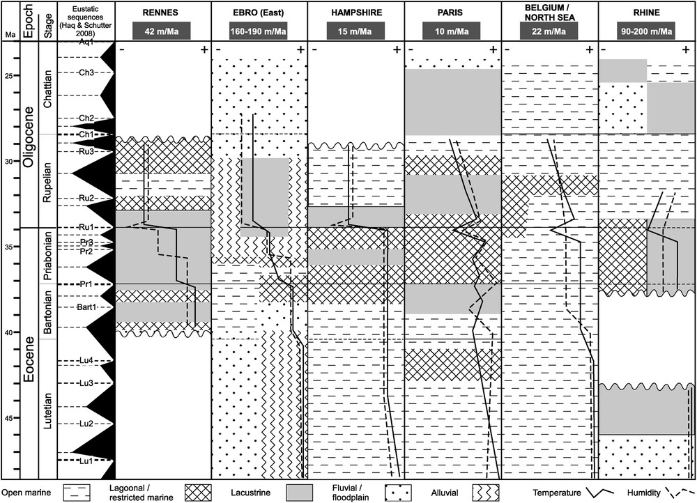
Palaeoclimatic evolution and palaeoenvironmental changes of the Rennes Basin with regards to other western European basins (adapted from Ollivier-Pierre et al., 1987). At the basin's scale, the Eocene–Oligocene Transition (EOT) is commonly marked by changes in depositional environment from marine or lagoonal to lacustrine or by oscillations around coastal settings. Nevertheless, the EOT in the Ebro Basin is fully terrestrial, whilst in the Rhine Basin it appears to be crossed continuously by salt deposits. Data for the Ebro Basin from Cavagnetto and Anadón (1996), Alonso-Zarza et al. (2002), Costa et al. (2010, 2013) and Barrón et al. (2010); for the Hampshire Basin from Collinson (1992), Hooker et al. (2004, 2009) and Costa et al. (2011); for the Paris Basin from Châteauneuf (1980) and Briais (2015); for Belgium and the North Sea from Vandenberghe et al. (1998) and Roche (1982); and for the Rhine Graben from Sittler (1965), Schuler (1983), and Roussé (2006). (Haq and Schutter, 2008).
The pollen assemblage reveals marked changes throughout the Lower Sapropels Fm., related to the global climate changes spanning the Late Eocene to Early Oligocene. The base of the formation is characterized by abundant megathermic flora, but Coniferales and Herbaceae developed from 265.90 m upwards and mesothermic forms became increasingly abundant, implying a new temperature drop. The short EOT (196 to 204 m in CDB1) is marked by a major impoverishment of warm dicots flora so that M. vanwijhei (Caesalpinia growing in xeric zones of South America and North Africa) was commonly isolated before the Rupelian marker B. hohli appeared. This is interpreted as a cooler, drier episode (Châteauneuf, 1980; Schuler, 1983, 1988) before the Rupelian climate returned to more humid conditions.
Finally, the cooler Rupelian climate of the N. crassatina Marls, Archiacina Limestone and Upper Sapropels formations is marked by mesothermic flora replacing the megathermic flora of the Eocene, as is also known in the Paris Basin from the Lowermost Oligocene (Sannoisian facies) up to the Fontainebleau Sands Fm. (Châteauneuf, 1980; Gruas-Cavagnetto, 1978). The rare remaining warm forms, such as Mussaenda or Alchornea, disappeared in response to a temperature drop during the coldest months (Mosbrugger et al., 2005), whilst an increase in the herbaceous fraction in the Upper Sapropels Fm. indicates a marked dryer season.
5 Discussion
5.1 Implications on the local and regional palaeogeography
The first results from CDB1 provide new insights about the Armorican palaeogeography. At least one period of intense weathering (see §4.1) is recorded before the onset of the Rennes Basin, bearing out the pre-Bartonian weathering of the massif already highlighted in previous studies (e.g., Wyns et al., 2003). Moreover, reworked Late Cretaceous foraminifera possibly argue for earlier marine flooding of the Armorican Massif during this period (see Bessin et al., 2015 for discussion).
For the Cenozoic times, four of the six well-recorded marine flooding events that affected the Armorican Massif (Guillocheau et al., 2003) are identified in CDB1. New data combined with published studies (see Guillocheau et al., 2003 for references) call for some palaeogeographical revision (Fig. 4):
- • the innermost extension of the Early to Middle Bartonian (Paris Basin: Biarritzian) transgression is seen in CDB1. This transgression was documented at the edges of the massif [e.g., at Saffré (Borne et al., 1991), Fyé (Châteauneuf, 1980) and Tréguier (Guennoc et al., 2015)] and in surrounding basins with the Limestones and Sands with Nummulites Brongniarti Fm. (Andreieff and Lefort, 1972; Paquet et al., 2010; Thomas, 1999). The biostratigraphic assemblages from these deposits, however, are spatially homogeneous, so no privileged (northward, southward or both) marine connection could be proposed for the Rennes Basin;
- • the Priabonian stage is formally identified in CDB1 (Paris Basin: Ludian). Together with biostratigraphic revisions of the scattered Cenozoic basins on the massif (e.g., the Saffré, Laval and Landéan basins), it clarifies the Priabonian palaeogeography. A regressive phase affected the overall massif, which only records lacustrine environments (∼ 180 m thick in the Rennes Basin) with some lagoonal areas located on its edges;
- • the Lower Rupelian transgression, already reported in the Rennes Basin (e.g., Ollivier-Pierre et al., 1993), probably came from the south, as argued by the distribution of preserved marine occurrences close to the Rennes Basin (Fig. 4);
- • for the Langhian–Serravallian transgression, the locations of marine occurrences and their palaeobathymetries favour the establishment of a north–south marine corridor linking the Channel basin and the South Armorican Margin, as already proposed by several authors (e.g., Thomas, 1999).
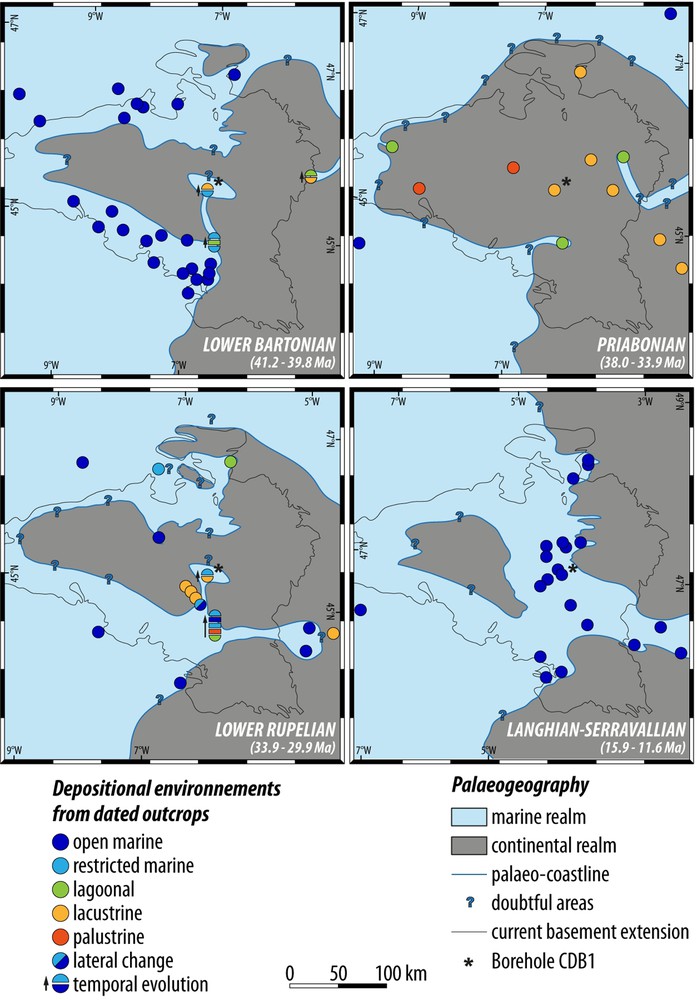
Regional palaeogeographical evolution from the Bartonian to the Langhian–Serravallian modified from Thomas (1999) and argued from published sedimentological and biostratigraphical data (see Guillocheau et al., 2003, for references).
These reviews suggest repeated flooding of the Armorican Massif during Cenozoic and even Mesozoic times.
5.2 Geodynamics of the Rennes Basin
The sedimentation rates for the different stratigraphic intervals of the Rennes Basin vary greatly from ca. 9 m/Myr during the Bartonian to ca. 44 m/Myr for the Priabonian interval. The thick Priabonian–Rupelian succession associated with a steady environment argues for an aggrading system with sedimentation compensating the accommodation rate. The sedimentation rate here is much higher than in the Saffré Basin for the same interval (ca. 18 m/Myr; Borne et al., 1991) with similar shaly deposits. By comparison (Fig. 3), the coeval deposits in the Ebro Basin and the Rhine Graben are much thicker with compacted sedimentation rates estimated from 90 to 200 m/Myr (Costa et al., 2011; Roussé, 2006). Conversely, the Paris Basin, Belgium Basin, and Hampshire Basin show very low sedimentation rates (10 to 22 m/Myr; Briais, 2015; Hooker, 2010; Vandenberghe et al., 1998, 2012). The sedimentary record of these basins also show discontinuities related to the overall low accommodation rates (intracratonic basins). The Rennes Basin sedimentation values averaging 42 m/Myr clearly lie between the high and low ‘end-members’.
Considering the geological settings and varying sedimentation rates, we consider that the Rennes Basin was initiated due to flooding of a preexisting topographic low of possibly greater extent, and then underwent a higher subsidence rate, maybe associated with strike-slip movements along the N140° faults during Priabonian to Early Rupelian times. This second phase is further supported by evidence of synsedimentary deformation (seismic line pinch out; Wyns et al., 2002) and could be due to relative movements between the African and Eurasian plates, as well as English Channel inversions (e.g., Ziegler, 1990).
5.3 Palaeoclimate change record of the Rennes Basin
Supporting the stratigraphic framework, the palynological study brings new data on the major Eocene–Oligocene climatic change (Fig. 3). The Bartonian to Priabonian saw a progressive change from a warm humid climate to a stronger seasonality, as previously reported by Ollivier-Pierre (1980) and Châteauneuf (1980) on a western European scale. The stronger seasonality was related to the development of a fresher drier season as indicated by Mosbrugger et al. (2005) and attested to by the progressive development of Coniferales and mesothermic flora. The EOT in the Rennes Basin is marked by an abrupt cooling during the Latest Priabonian before the FO of B. hohli; an abrupt climatic change also reported in the Paris Basin (Châteauneuf, 1980), the Rhine Graben (Schuler, 1988), the Hampshire Basin, and the Belgium Basin (see Ollivier-Pierre et al., 1987, for a review). This can also be related to the global cooling events recorded worldwide, i.e. the EOT and subsequent “Oi” glacial events (e.g., Katz et al., 2008), and is connected to the initiation of the Antarctic ice sheet (e.g., Zachos et al., 2001). Although the associated base-level drop is not well-recorded in the Rennes Basin, a moderate sea level drop of 15 m or more is estimated in the less subsiding Hampshire Basin (Hooker, 2010; Hooker et al., 2007). It is therefore likely that the higher subsidence in the Rennes Basin compensated the sea level drop without any major environmental change.
The climate record of the Rennes Basin appears to reflect a stepwise change from a warm, humid Bartonian climate to a cooler, drier climate around the EOT before a return to more humid conditions. This record is consistent with those of other western European basins and notably that of the Ebro Basin (Fig. 3). Whether the slight discrepancies are due to real local climatic differences, or to high-frequency changes coupled with low-resolution sampling of various studies, is still an open question. The Paris Basin record appears more chaotic, but this could reflect a higher-resolution fluctuation or the influence of variable depositional environments. Such environmental changes across the EOT are widespread in the western European terrestrial records, so climate signals would be more complex to decipher (Fig. 3). In this respect, the CDB1 record looks like promising material in that the depositional environment remained lacustrine/palustrine from Early Priabonian to Early Rupelian, embracing the entire EOT.
6 Conclusions and outlook
The CDB1 core is the first full record of the sedimentary infill of the Rennes Basin and its weathered substrate, and the most comprehensive record of Cenozoic deposits in the Armorican Massif. It brings new findings towards the understanding of the Cenozoic geological, palaeogeographical, and climatic evolution of this region:
- • a continuous Cenozoic lithostratigraphic and biostratigraphic framework is described, with seven formations defined from CDB1 and previous studies. The basin deposits begin with the Chartres-de-Bretagne Fm. (Early–Middle Bartonian) followed by the 290-m-thick organic and shaly Lower Sapropels Fm. (Priabonian–Early Rupelian) overlain by the N. crassatina Marls and Archiacina Limestone formations (Early Rupelian), and then by the Upper Sapropels (Late Rupelian) and the Faluns and Lithothamniids Limestone formations (Middle Miocene);
- • a hinterland marine incursion of the Bartonian transgression, largely documented from the southern Armorican coast, is evidenced. The Priabonian is formally described and the Eocene–Oligocene boundary recognized within the lacustrine deposits;
- • comparison with other western European basins shows that the sedimentation rates of the Rennes Basin are intermediate between an intracratonic basin and a true graben. It also remained a continuous lacustrine environment from the Late Eocene to Early Oligocene, whereas most of the other basins underwent environmental changes at the EOT;
- • the Rennes Basin is a unique record of the EOT and illustrates a gradual climate change from the Early Priabonian to the very Late Priabonian before a rapid cool arid event took place just prior to the Oligocene.
These first results from CDB1 are really promising for further studies concerning the Armorican Cenozoic history and also for a better understanding of the EOT in continental settings.
Acknowledgements
The authors would like to thank the BRGM and the AELB and ADEME agencies for their financial support to the CINERGY project. Borehole CDB1 was funded by the CG35, Région Bretagne, Métropole Rennes, Chartres-de-Bretagne city council, the “Préfecture de Bretagne”, IAV, SMPBR, and SMG35, and was drilled by COFOR. We also thank all the CDB1 scientific party, as well as Pierre Lozouet (MNHN) for the malacostratigraphy. The initial manuscript greatly benefited from comments and suggestions from Miguel Garcés and Torsten Utescher. We should also like to thank Sir Patrick Skipwith, former Head of Translation at BRGM, for editing the English.