

1 Introduction
At the northern outskirts of the West African Craton (WAC), Paleozoic terrains crop out widely in the Anti-Atlas and the Atlas–Meseta domains (Fig. 1A). Cambrian to Lower Carboniferous strata crop out almost continuously in the Anti-Atlas and its eastern continuation in Algeria (Bechar Basin, Ougarta). Being moderately deformed and rich in well-preserved fossils (e.g., Destombes et al., 1985; Hollard, 1981), they provide reference stratigraphic columns for the proximal Gondwana margin north of the Tindouf cratonic basin. Further to the north, the Atlas–Meseta domain displays more restricted Paleozoic outcrops in the form of discontinuous inliers or massifs surrounded by their Mesozoic–Cenozoic cover rocks. Moreover, most of these Paleozoic massifs are made of strongly deformed rocks, affected by low- to high-grade metamorphism and intruded by a number of mafic and felsic magmatic rocks. They belong to the Variscan Meseta orogen, whose southern foreland fold belt corresponds to the Anti-Atlas (Hoepffner et al., 2005; Michard et al., 2010, and references therein).
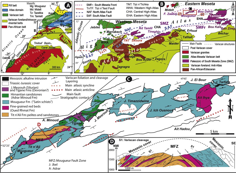
A. Location of the contact zone between Anti-Atlas and Atlas–Meseta domains. B. Zoom of the cited contact zone showing the South Meseta Zone (SMZ) and the location of the Mougueur massif and other central and eastern High Atlas inliers (see location in A). C. Simplified geological map of the Mougueur Paleozoic Massif (see location in B). D. Cross-section showing the complex structure of the Massif (see location in C).
The Mougueur Paleozoic Inlier (latter referred to as “Mougueur Massif”) studied here occupies a key location in the transition zone between the two major structural domains of the Variscan Orogen of Morocco, i.e. the so-called South Meseta Zone, mostly hidden beneath the High Atlas Mesozoic–Cenozoic strata (Fig. 1B). Contrary to the analogous Ait Tamlil and Skoura massifs to the west (Jenny and Le Marrec, 1980; Laville, 1980) and the large Tamlelt massif farther to the east (Houari, 2003; Houari and Hoepffner, 2003), the Mougueur Massif has been seldom studied up to now. The outcrops were classified for long as “Paleozoic or Precambrian sericitoschists and quartzites” (Caïa, 1969; Choubert et al., 1956) or as Cambrian metasediments (El Kochri, 1981). On the geological map of Morocco, scale 1:1,000,000 (Hollard et al., 1985), the Mougueur Massif is shown as Middle Cambrian and/or Ordovician metasedimentary rocks. Later, the Mougueur Massif was recognized yet, with no attention to the stratigraphic age of its folded rock material.
The aim of the present paper is to provide new data on the Mougueur Massif stratigraphy and derive an updated interpretation of the transition zone between the Meseta Orogen and its Anti-Atlas foreland. We present a new cross-section of the massif and provide, for the first time, the stratigraphic column of the Mougueur Massif. By comparing the new stratigraphy with the reference succession of the Anti-Atlas, we conclude that the Mougueur Massif was part of the northern Gondwana passive margin during the Cambrian–Devonian.
2 Geological setting
The contrasting Paleozoic structures of the Anti-Atlas and the Atlas–Meseta domains are sharply separated by the Tizi n’Test Fault in the Marrakech High Atlas and west of it (Fig. 1B). In contrast, a transition zone, also labeled South Meseta Zone (SMZ; Michard et al., 2010), extends east of the Marrakech High Atlas Ouzellarh massif up to the Algerian border. The SMZ is loosely bounded to the north because of the Mesozoic–Cenozoic cover, except in the Tamlelt massif whose northernmost part may be ascribed to the Meseta orogen, whereas its central and southern parts exhibit Anti-Atlas affinities (Choubert et al., 1956; du Dresnay, 1976; Houari and Hoepffner, 2003; Pelleter et al., 2007). The southern boundary of the SMZ is marked by the South Meseta Front (SMFr), which is exposed either inside the High Atlas in the western inliers of Ait Tamlil and Skoura, or further to the east at the northern fringe of the Anti-Atlas south of Tineghir and northeast of Bechar.
South of the SMFr, the thickness of the Anti-Atlas Paleozoic sediments exceeds 8 km in the Zagora region and decreases down to ∼ 4 km in the Erfoud/Tafilalt region (Hoepffner et al., 2005; Michard et al., 2010; Soulaimani and Burkhard, 2008). The sedimentary pile is dominantly clastic, but carbonates are well-developed in the Western/Central Anti-Atlas in Lower Cambrian formations, and everywhere in the Devonian (then recording platform formation in the Tafilalt area) and part of the Visean formations. The Paleozoic strata are weakly detached from their faulted Precambrian basement and affected by kilometer-scale, upright open folds, the axes of which are partly controlled by the trend of the basement faults (Baidder et al., 2008, 2016). Similar Paleozoic stratigraphy and structures are observed in the Bou-Kaïs and Ben Zireg/Talzaza massifs of the Bechar region (du Dresnay, 1976; Seddiki et al., 2004).
The Paleozoic massifs of the Atlas–Meseta domain exhibit varied stratigraphic sequences from west to east (Hoepffner et al., 2006, 2017; Michard et al., 2008, 2010). The thickness of each sequence is about half of that typical of Anti-Atlas. Carbonates are very restricted in the Lower Cambrian. Reef facies record the development of a Devonian platform in the western/central Meseta (Eichholt and Becker, 2016) whereas clastic turbidites formed contemporaneously in the central/eastern areas (Piqué and Michard, 1989). Synsedimentary mafic intrusions emplaced in the western subsiding Visean basin before its Namurian–Westphalian closure, and granitoids intrusions were widespread after that collisional closure. Shortening occurred mostly in a NW–SE direction, which rotated to a SW–NE orientation in the southern parts of the central/eastern Meseta (Jebilet, Ait Tamlil), and to the south along the SMFr (Fig. 1B).
The Variscan evolution at the northwestern outskirts of the WAC is interpreted in the frame of the Paleozoic oceans (Cambrian–Ordovician rifting and spreading, Nance et al., 2012; Ouanaimi et al., 2016; Pouclet et al., 2018), and then of the closure of the Rheic ocean during the Devonian–Carboniferous (Edel et al., 2018; Frizon de Lamotte et al., 2013; Hoepffner et al., 2017; Martínez-Catalán et al., 2007; Michard et al., 2010; Pérez-Cáceres et al., 2017; Simancas et al., 2005). The post-collisional evolution is characterized by the development of subaerial molasses and calc-alkaline felsic magmatism (Youbi, 1998) in a context of transtensional tectonics (Saidi et al., 2002).
3 Data and methods
The classical methods of field geology have been used to acquire stratigraphic data and derive the stratigraphic succession in the Mougueur Massif. Detailed mapping of the whole massif was achieved during the current mapping project concerning several 1:50,000 quadrangles of the eastern High Atlas in the frame of the “Programme national de cartographie géologique” of the Moroccan “Ministère de l’Énergie, des Mines et du Développement durable”.
Observations were made on sedimentary figures and structures to approach the depositional environments and sedimentary processes. Numerous samples were collected for microscopic study of the sedimentary facies. Paleontological diagnosis of the collected fossils, i.e. the Silurian graptolites, has been performed at the Marrakech University.
4 Results
4.1 Map and cross-section
The sketch map (Fig. 1C) and the corresponding cross-section (Fig. 1D) show that the Mougueur Massif crops out at the crest of an Alpine (Atlasic) faulted antiform. This implies that at least some of the faults within the Paleozoic core of the antiform, and particularly the Mougueur Fault Zone (MFZ), were active during the shortening of the Atlas. Most of the Mougueur Massif outcrops are made of “Schistes satinés” (El Kochri, 1981), i.e. greenish satin metagreywackes here classified as Ordovician (see below). The main crest culmination northeast of the Mougueur village reveals the oldest, Cambrian strata, whereas the youngest, Silurian, and Devonian strata, are preserved in the saddle next to Adrar Minoud and Tijjane. A minor culmination occurs at the eastern tip of the crest (Ait Ihya), close to the Jurassic syenite intrusion of J. Tarfafa (du Dresnay, 1976). The profile across the main culmination (Fig. 1D) makes visible the occurrence of two blocks of folded Paleozoic formations, which differ by the dip of the fold axial planes and associated tectonic foliation. They are separated by the main Mougueur Fault Zone. The northern block has been tilted to the north by ∼ 30° during the Atlas folding, and then the pre-Triassic dip of the foliation was close to 15°N (Hoepffner et al., 2006). The southern block has been probably tilted southward during the shortening of the Atlas. Variscan folding occurred in greenschist-facies conditions, which partly accounts for the scarcity of fossil remains in the whole sequence.
4.2 Stratigraphic column
The stratigraphic column we inferred from our study is summarized in Fig. 2B. The age proposed for each newly defined formation is deduced from the facies comparison with the Anti-Atlas reference column (Fig. 2A), except when diagnostic fossils occur (Silurian). The formations (Fms.) identified are briefly described below, from bottom to top.
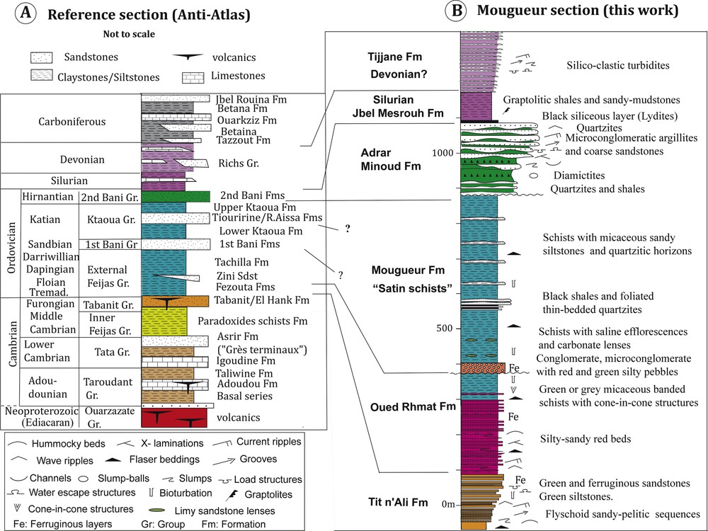
A. Synthetic stratigraphic column of the Paleozoic of Morocco as defined in the Anti-Atlas (not to scale; stratigraphic calibration after Videt et al., 2010). B. Stratigraphic column of the studied area (this work), with the proposed correlations with the Middle-Upper Cambrian to Lower Devonian Anti-Atlas formations.
4.2.1 Tit n’Ali Fm.
This formation has been described by El Kochri (1981) under the name of Tigillite sandstones. We may separate two units:
- • the flyschoid unit (150–200 m): alternating sandstones and green siltstone beds that can form thickening upward sequences ending with quartzite. The sandy beds pass gradually to siltstones, thus forming graded sequences. Wavy bedding, plane- and cross-laminations, current ripples, groove structures and bioturbations are frequent;
- • the sandstone unit (60–100 m): ferruginous quartzarenite and quartzwacke metric, lenticular beds, locally microconglomeratic, alternating with subordinate shales. The sedimentary structures observed in the underlying formation also occur here. In addition, soft-sediment deformation, such as large load casts and fluid-escape structures resulting in pseudo-nodules, are frequent.
The Tit n’Ali Fm. constitutes a thickening and coarsening upward sequence (Fig. 3A). Sediments were deposited on a shallow clastic platform with relatively distal silico-clastic spreads distributed by tidal or wave currents with occasional turbid sediments.
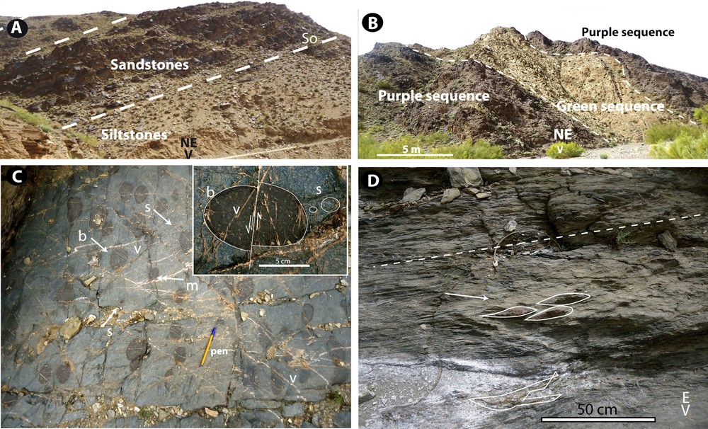
A. Tit n’Ali formation (Middle Cambrian): Sandstones and intercalated siltstones (GPS point 32.438776°N/4.103224°W). B. Oued Rhmat formation (Floian): alternation of purple and green sequences at Ait Ihya (GPS 32.510°N/3.775°W). C. Structural surface of a sandy conglomeratic unit at the base of the Mougueur Fm. with rounded or ellipsoidal red pebbles of various grain sizes (arrows, b: big; m: medium; s: small pebbles) reworked from the Oued Rhmat Fm. Pebbles are flattened and stretched in the cleavage plane and eventually fractured and crosscut by quartz veins (v). D. Argillaceous black slates with saline efflorescences and deformed limy sandstones concretions (arrow). Dashed line: cleavage.
4.2.2 Oued Rhmat Fm.
This formation has been previously labeled as “purple schists” or “red formation” (Caïa, 1969; El Kochri, 1981), and described by Ouanaimi et al. (2016). This remarkable formation is made of alternating green and red (violin and purplish) sandy-pelitic decameter-thick beds. The estimated thickness is > 300 m in the easternmost part of the massif. Graded beds are often organized in thickening and coarsening upward sequences including numerous positive elementary sequences. The fine-grained facies are shales or silt-clay couplets with lenticular or flaser bedding. The sandy beds show ripples and some small hummocky structures. The less colored laminations are dominantly made of quartz grains, whereas the dark ones are micaceous with oxidized lamellae of biotite, chlorite, and muscovite. Diagenetic processes contributed to Fe exsolution and redistribution within the layers. Reworked red pebbles are found in the overlying sediments (Fig. 3C), suggesting an early diagenesis. Sedimentary structures attest to shallow marine conditions in a clastic platform with tide- and wave-dominated processes, probably in a deltaic front context.
4.2.3 Mougueur Fm.
This formation corresponds to the satin schists and green sandy schists with carbonate nodules defined by El Kochri (1981). The dominant facies are monotonous metapelites, by place showing thin alternations of quartz-rich and muscovite-chlorite-rich lamellae. Structures of tide-dominated processes such as flaser and lenticular beddings are observed, as well as hummocky beddings attesting to intermittent storm actions. The highly deformed facies of the easternmost part of the massif locally contain lenses of dilacerated quartzites or sandstones. The most complete section is observed close to the Mougueur village and begins above large lenses of Oued Rhmat Fm. Pebbles reworked from this formation give the stratigraphic polarity of the profile. The Mougueur Fm. begins with banded metapelites, sometimes bioturbated and containing cone-in-cone structures. These are topped by conglomeratic sandstones (30 m) rich in rounded or angular pebbles of red sandstone scattered in a fine-grained matrix, and more or less flattened parallel to the Variscan cleavage (Fig. 3C). This remarkable facies of monogenic conglomerate with matrix-supported pebbles and cobbles would derive from the submarine collapse of the sedimentary prism. Some oblique, slightly sigmoidal layering can be observed as well as thin oxidized chloritic layers with pyrite crystals.
The conglomeratic unit passes upward to micaceous bioturbated shales (100 m) with saline efflorescences and carbonate nodules (Fig. 3D). Foliated rhythmic quartzites are interbedded within the shales. The sequence ends with thick greenish shales with micaceous sandy-pelitic and quartzitic layers.
4.2.4 Adrar Minoud Fm.
This formation is here described for the first time, based on outcrops in the Tijjane–Adrar Minoud and NW J. Mesrouh areas (Fig. 1C). The Adrar Minoud section shows above the Mougueur Fm. a sequence of microconglomeratic sandy argillites (30 m; Fig. 4B, D), black shales (20 m) and sandstones (30 m). This sequence is followed by a thickening upward sequence of lenticular and channeled quartzites and sandstones alternating with greenish micaceous and bioturbated shales (50 m). The sandstones show rare flute-casts and frequent load casts and water-escape structures. In the NW J. Mesrouh section, the formation shows slight variations with respect to the Adrar Minoud section. The black shales of the lowest sequence are replaced by coarse graveled sandstones, suggesting channelized sedimentation. In the top sequence, lenticular geometry of the sand bodies is conspicuous (Fig. 4A). Wave ripples are frequent.
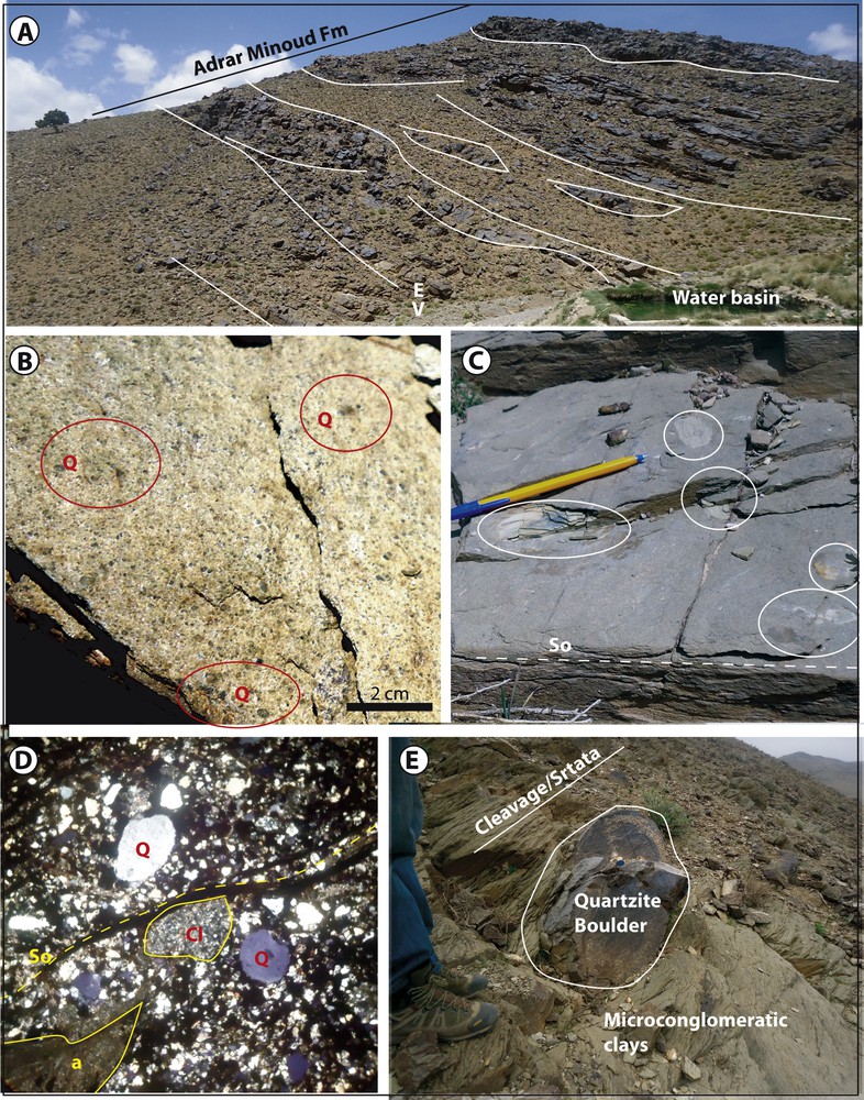
Adrar Minoud formation (Hirnantian). A. Channelized sandstones, quartzites and microconglomeratic argillites in the Tijjane area (GPS 32.472°N/4.014°W). B. Close view of typical sandy microconglomeratic argillites with scattered spheroidal quartz grains and granules (Q). C. Microconglomeratic slates with pebbles and clasts of similar slates. D. Micrography of facies (B). a: deformed argillaceous pebble; Cl: quartzarenite clast; Q: quartz clast; So: bedding. E. Quartzite boulder (dropstone) hosted in microconglomeratic argillites; Adrar Minoud, GPS 32.46°N/4.068°W.
Sedimentation of the Adrar Minoud Fm. likely occurred on a shallow marine platform with spreading submarine sand bars and channels. Moreover, a periglacial context is testified by the microconglomeratic sandy argillites characterized by scattered, rounded quartz grains, and spherules (Fig. 4B, D). The fine-grained fraction of these litharenites is dominantly formed by angular grains (Fig. 4D). This diamictites facies also contains centimeter-sized gravels, and scattered elements of black shales and pelites flattened in the stratification plane (Fig. 4C). Eventually, boulders of various size and lithology interpreted as dropstones (ice-rafted elements) are frequently observed (Fig. 4E), such as carbonate sandstones with internal hydroplastic folds.
4.2.5 Jbel Mesrouh Fm.
This formation (∼ 100 m) corresponds to graptolite-bearing slates or shales identified for the first time in the Mougueur Massif. At GPS point 32.4835°N/4.023°W, the basal contact of the J. Mesrouh shales on top of the Adrar Minoud quartzites (Fig. 5A) is marked by some thin (5 to 50 cm) siliceous layers (lydites) suggesting rapid immersion of the area. The overlying shales are interbedded with thinly-bedded sandy layers without observable graptolites. The first graptolite fossils are found about 10 m over the basal contact, in altered light-colored shales (Fig. 5B). Other graptolites are found within the Silurian lenses pinched in the faults that duplicate the Adrar Minoud Fm., for example at the GPS point 32.483°N/4.0254°W.
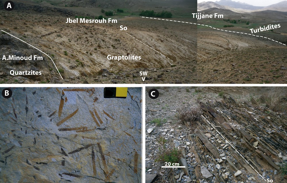
A. Panorama on the Hirnantian-Lower Devonian succession. GPS 32.4835°N/4.023°W. B. Graptolites-bearing slates of J. Mesrouh Fm. C. Silico-clastic turbidites of the Tijjane Fm.
Preliminary results of the fauna determination reveal the occurrence of Saetograptus chimaera Barrande, Monograptus varians Wood, Colonograptus roemeri Barrande, Monograpus nilssoni Barrande, Bohemigraptus bohemicus (Barrande), Monograptus scanicus Tullberg, and Monograptus vomerinus Nicholson. This fauna association corresponds to the base of Upper Silurian, i.e. lower Ludlow (or Gorstian).
4.2.6 Tijjane Fm.
This formation (> 200 m) is exposed in the Tijjane plain above the Silurian shales (Fig. 5A, C) and beneath the Triassic siltstones and/or basalts. The basal part shows thinly-bedded alternations of sandstones and silts or black shales, with a progressive change from the Silurian J. Mesrouh Fm. to the overlying Tijjane Fm. Stratigraphically upward in the Tijjane plain, 20–30-cm-thick sandy layers occur, seemingly forming thickening upward sequences. The sand/clay couplets are graded Bouma sequences with sharp erosional bases showing sometimes grooves and flute-casts, followed upward by cross-laminated sandstones, and current ripples at the top, passing gradually to planar laminas and micaceous silts locally bioturbated. Most of the beds seem to be planar over hundreds of meters, but lenticular beds are also observed. Eventually, slumps and water-escape structures (convolute beddings) are frequent, attesting to gravity-driven processes in the sediment prism.
Thus, the Tijjane formation can be regarded as a distal part of a turbidite fan down-lapping the Silurian shales without interruption of the sedimentation.
5 Discussion
5.1 Age and analogies
At the bottom of the Mougueur Massif, the Tit n’Ali Fm. can be considered as a coeval homolog of the Middle–Upper Cambrian El Hank Fm. of the western Meseta (El Kochri, 1981; Oukassou et al., 2017), and of the Tabanit Group of the Anti-Atlas, with some beds similar to the underlying Inner Feija Gp (Destombes, 2006). This formation evokes a distal, flysch-like sedimentation comparable to that of the slightly more proximal Hassi Douis Fm. of the Tamlelt inlier (du Dresnay, 1976).
The Oued Rhmat Fm. is not directly dated in the Mougueur Massif, but we assume a Floian age based on its analogy with the paleontogically dated Foum Zaabel reddish pelites (Bazin, 1968). Such Lower Ordovician red beds are widespread in the Atlas–Meseta domain, and have been interpreted as derived from marginal faulted basins developed in relation with the Rheic Ocean rifting (Ouanaimi et al., 2016). This rifting phase is also recorded by the Rabat Lower Ordovician pillow lavas (El Hadi et al., 2014; Tahiri and El Hassani, 1994), and continues in the Early Cambrian–Lower Ordovician extensional period, well known in the Anti-Atlas and the western Meseta domains (El Hadi et al., 2006; Letsch et al., 2017).
The Mougueur Fm. overlies the Oued Rhmat Fm., which is locally reworked in conglomerates included in the lower part of the Mougueur Fm. sequence, and underlies the glaciogenic Adrar Minoud Fm., which can be referred as Hirnantian (see below). Thus, the Mougueur Fm. age may range from upper Floian to Katian. However, the Mougueur Massif banded facies evoke the Lower Ordovician “Schistes demi-deuil” of the western High Atlas (Cornée and Destombes, 1991). The black shales with saline efflorescences and the quartzite beds are frequent in the Skoura, Tizi n’Tichka, and Western High Atlas inliers, where they have been attributed to the Middle–Upper Ordovician (Destombes et al., 1985). In contrast, these distal platform facies clearly differ from the proximal deposits of the thick sandstones and quartzite formations of the first Bani and Ktaoua observed in the Anti-Atlas (Fig. 2A). It is worth noting that the Sandbian–Katian quartzite formations found in the Bou-Dahar and Tamlelt inliers (Agard and du Dresnay, 1965; du Dresnay, 1976) do not crop out in the Mougueur Massif, possibly because of glacial regression and erosion before the sedimentation of the Adrar Minoud Fm.
The Adrar Minoud Fm. is attributed to the Hirnantian stage (second Bani Group of the Anti-Atlas) as it underlies the Silurian graptolite shales and shows periglacial facies as in most Moroccan regions (Destombes et al., 1985). We ascribe the microconglomeratic sandy argillites of this formation to marine diamictites comparable with the classical marker of the Anti-Atlas second Bani formation (Destombes et al., 1985) and the High Atlas (Ouanaimi, 1998). This marker is also well documented in the Saharan platform (Ghienne, 2003, and references therein). The two levels of microconglomeratic sandy argillites of the Mougueur Massif can be correlated with the two glacial advance/retreat phases first recorded in the Tizi n’Tichka area (Ouanaimi, 1989, 1998). Such glacial-warming sequences are discussed by Ghienne et al. (2007) and Dietrich et al. (2018). The paleogeographic context of the Mougueur Massif corresponds to a shallow marine platform submitted to high-energy erosion and sedimentation extending in a relatively distal position with respect to the striated glacial floors and continental glacial sedimentation described in the Anti-Atlas (Le Heron et al., 2018 and references therein).
The Jbel Mesrouh Fm. is paleontogically dated from the Gorstian stage of the Upper Silurian, whereas Lower and Middle Silurian stages are known in nearby High Atlas inliers (Agard and du Dresnay, 1965; Jenny and Le Marrec, 1980; Laville, 1980; Ouanaimi, 1998) as well as in most of the Meseta and Anti-Atlas domains (Destombes et al., 1985; Zahraoui, 1994). These stages are possibly “condensed” in the 10-m-thick azoic shales below the first graptolite-bearing levels in the Mougueur Massif outcrops. However, we cannot exclude that this massif was an extensional high during the Lower–Middle Silurian, as observed in some areas of the western High Atlas (Cornée et al., 1987) and the Meseta (Destombes et al., 1985). In the western Meseta domain, this extensional regime is also documented by alkali-basalt flows and dykes (El Kamel et al., 1998).
The Tijjane Fm. follows upward the J. Mesrouh Fm. with a rapid change of sedimentary facies from shales to silico-clastic turbidites. The latter facies is poorly represented in the Lower Devonian deposits of the Anti-Atlas, which correspond generally to shaly, sandy, and calcareous platform deposits (Eichholt and Becker, 2016; Hollard, 1981; Ouanaimi and Lazreq, 2008). In contrast, Pragian to Upper Devonian turbiditic sequences characterize the central-eastern part of the Meseta domain (Hoepffner et al., 2005, 2006; Zahraoui, 1994). Likewise, Bougarra et al. (2012, 2018) describe a Praguian–Emsian turbiditic complex in the Saïda area of northwestern Algeria. Hence, we may suggest that the Mougueur Massif was at that time a distal part of the turbiditic fan that extended further to the north in the central-eastern Meseta and northwestern Algeria.
As a whole, the lithostratigraphy of the Mougueur Massif compares well with that of the Tamlelt and Bou-Dahar inliers of eastern High Atlas, and even more strikingly with that of the Tazzeka Massif in the Middle Atlas further north (Fig. 1A). The latter massif exposes Ordovician formations nearly identical to those of Mougueur, followed upward by the classical Silurian-Lochkovian clayey facies (Hoepffner, 1977; Ramirez Merino et al., 2008a), and finally by Lower Devonian turbidites (Amaouin, 1991; Ramirez Merino et al., 2008b).
5.2 Pre-orogenic tectonic setting
The above reported comparisons of the Mougueur Massif formations with the coeval formations of the Anti-Atlas and Atlas–Meseta domains reveal the systematic tendency to be transitional from one domain to the other. Moreover, each stage is represented in the Mougueur Massif by formations more distal than their homolog in the Anti-Atlas, and equivalent to or less distal than their homolog in the Atlas–Meseta:
- • during the Cambrian, the Tit n’Ali Fm. is more distal than the Anti-Atlas Tabanit Gp, and similar to the Cambrian of the western/central Meseta (Letsch et al., 2017; Oukassou et al., 2017, and references therein);
- • during the Floian, red beds accumulate in the Mougueur Massif as in the Meseta, in contrast with the situation in the Anti-Atlas;
- • the Middle–Upper Ordovician is represented in the Mougueur Massif by facies more distal than those of the Anti-Atlas, and similar or even less distal than those of the western/central Meseta;
- • the Hirnantian diamictites are similar to those of the Meseta domain, but they show larger dropstones; they are marine and much less coarse than the coeval continental diamictites of the Anti-Atlas;
- • the Silurian post-glacial black shales deposited over an uneven bedrock and are then stratigraphically incomplete;
- • the Lower Devonian formation of the Mougueur Massif corresponds to a silico-clastic turbidite fan seemingly emplaced from the Anti-Atlas southern platform area toward the Meseta northern deep sea.
In summary, the Mougueur Massif shows a Lower–Middle Paleozoic sequence typical of a relatively distal part of the WAC passive margin, whereas the Anti-Atlas represents its proximal part and the Atlas–Meseta its more distal part.
6 Conclusion
Detail mapping and lithological analyses of the Mougueur Paleozoic Massif in the eastern High Atlas allowed us to decipher its stratigraphy and the corresponding sedimentary environments from the Middle–Upper Cambrian to the Lower Devonian. The sedimentary facies recognized in the Mougueur Massif are remarkably transitional between those of the Anti-Atlas and the Atlas–Meseta domains. This enlightens the relationships of the Atlas–Meseta Variscan orogen with the WAC, frequently discussed. Whereas the Anti-Atlas corresponds doubtlessly to the inner margin of the WAC, the Mougueur column illustrates a more distal part of this margin during the Lower–Middle Paleozoic extensional evolution of Gondwana. The fact that the Mougueur lithostratigraphy is also transitional toward the Atlas–Meseta domain supports the interpretation that the latter was derived from the most distal passive margin of the West African Craton.
Acknowledgements
Field works were performed in the frame of the “PNCG” program of the “Ministère de l’Énergie, des Mines et du Développement durable”, Morocco. Authors are grateful to Prof. N. Lazreq (Cadi Ayyad University, Marrakech) for graptolites determination and to reviewers André Michard, Mohamed Tahiri, and Isabelle Manighetti for their help and constructive remarks.