1 Introduction
Located in northern Niger, the NW–SE-trending Téfidet trough is part of a set of Cretaceous troughs belonging to the Ténéré graben megasystem, extending from southern Algeria towards Lake Chad, over a distance of about 1200 km (Fig. 1, Ahmed et al., 2016; Pouclet et al., 1994). The Ténéré megasystem includes a set of coalescent grabens, connecting towards the south with the Nigerian NE–SW-trending Benue trough (Ahmed et al., 2016; Benkhelil, 1986).
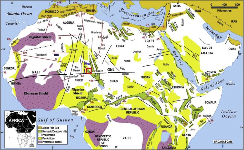
Schematic geological map of Northeast Africa, Central Africa and Arabia. Compilation after Wilson and Guiraud (1992). The main fault zones and rifts are shown. AG: Abu Gharadig; B: Bioko; CAFZ: Central Africa Fault Zone; Cyr: Cyrenaica; Sirt: Syrt Basin; E: Eratosthenes island; JP: Jos Plateau; P: Principe; Pag: Pagalu; S: Salamat; ST: São Tomé; Te: Termit; GNL: Guinean–Nubian Lineament; Rag: Raghane shear zone. The red box outlines the location of the study area (The Téfidet trough).
The Téfidet trough is an asymmetric graben oriented N140° on average. It represents the western branch of the Ténéré rift system. It extends in the Aïr Mountains over about 120 km and is limited to the west by the Raghane shear zone (Fig. 1), which represents the western boundary of the Saharan metacraton (Abdelsalam et al., 2002; Liégeois et al., 1994, 2013).
Towards the southeast, the Téfidet trough is separated from the Termit basin by a system of strike slip faults oriented ∼N75° (Fig. 1), called Agadez Line (Genik, 1992) or the Guinean–Nubian Lineament (GNL) (Guiraud and Bosworth, 1997; Wilson and Guiraud, 1992).
The Téfidet trough has a singular position between the Lybian (Syrt, Cyrenaica) and the Tunisian equivalent troughs to the north and west and the Central African Cretaceous rifts to the south (Benue, Doba, Muglad) (Fig. 1). Most of the African Cretaceous rifts (Syrt, Cyrenaica, Gargaf, Termit, Bongor, Doba, Fig. 1) have a NW–SE trend as Téfidet through. They thus might have been generated by the same geodynamic event. A tectono-sedimentary analysis of the Téfidet trough might help addressing this question.
However, apart from the geological work, Faure (1966) and Kehrer et al. (1975) and a gravimetric study by Louis (1970) and Louis and Rechenmann (1966), no detailed tectono-sedimentary analysis of the Téfidet trough has been conducted so far. The main objective of this study is thus to characterize the tectono-sedimentary infilling of the Téfidet trough from Cretaceous to Cenozoic. A second objective is to compare the structural evolution of the Téfidet trough with that of the equivalent troughs of West, Central and North Africa. This might allow understanding the structural evolution of the Téfidet trough in the framework of the North, West and Central African rifting, especially during the Cretaceous break-up of the Gondwana (Guiraud and Maurin, 1992) and during the Cenozoic (Genik, 1992).
To determine the main tectonic phases, which have affected the Téfidet trough, we have identified and analysed the faults and folds at different scales from metric to kilometric using a combination of satellite data analysis and field investigations. The field investigation led us to acquire a population of several tens of measurements in a small area, mainly orientation of fault surfaces and striae, bedding planes, fractures. Field data were mainly collected on the western border of the Téfidet trough (over an estimated area of approximately 50 km × 20 km) where outcrops are accessible, such as Lower Cretaceous sediments, Cenozoic volcanic rocks and Precambrian basement. Nearly 150 microfault planes and 40 conjugate microfracture planes and about ten fold axes were identified.
At a larger scale, a Google Earth image of the Téfidet area displays many kinds of geological features. These are, on the one hand, fractures, faults, syncline structures ranging from hectometric to kilometric scale and, on the other hand, progressive unconformities, layer thickness variations decametric to hectometric in scale. Successive tectonic phases are calibrated chronologically by discriminating the deformations that affect each of the three dominant terrains in the Tefidet trough, of Lower Cretaceous, Upper Cretaceous and Cenozoic age.
2 Geodynamic context
2.1 Cretaceous tectonic context
The original breakup of the supercontinent Gondwana in the present South America and Africa continents, occurred from Upper Jurassic to Lower Cretaceous (Binks and Fairhead, 1992; Genik, 1992, 1993) and led to the opening of the South Atlantic Ocean. The rifting deformations documented in West and Central Africa are thought to be related to this Gondwana break-up (Genik, 1992; Guiraud and Maurin et al., 1992). The Ténéré rift system, which is genetically related to the Benue trough (in Nigeria, Fig. 1) and has the same structural setting (Alalade and Tyson, 2010; Mohammed et al., 1999; Obaje et al., 2004), belongs to the West African Rift Subsystem (WARS) (Genik, 1992) and is Cretaceous to Tertiary in age (Fig. 1).
The WARS and the Central African Rift Subsystem (CARS, Genik, 1992), which extend in Central African Republic and Sudan, form the West and Central African Rifts System (WCARS) (Fairhead, 1988; Genik, 1992, 1993; McHargue et al., 1992; Schull, 1988). This system (WCARS) that extends from Mali (Gao trough) to Sudan developed in the earlier stages of the Gondwana break-up, i.e. in the Lower Cretaceous.
The South Atlantic Ocean opened in Early Cretaceous and this spreading tectonic episode affected the Saharan domain, whose old fault systems were reactivated while new tectonic troughs developed, such as in the Ténéré region (Rougier et al., 2013). In these troughs, the thickness of the Cretaceous sediments is commonly up to 3 km (Genik, 1993), except in the Téfidet trough, where it hardly reaches 1 km (Faure, 1966; Kehrer et al., 1975).
The formation of the Téfidet trough and the other Ténéré grabens is synchronous with that of the Benue trough (Guiraud, 1990; Popoff, 1988). The N60° trending faults of the Benue trough may have acted during the Early Cretaceous as a transfer fault (Guiraud, 1990; Popoff, 1988) between the Téfidet extensive zone and the Atlantic opening (Charcot transform fault, Benkhelil, 1986).
2.2 Cenozoic tectonic context
The Aïr Massif's overall morphology was acquired during the Cenozoic uplift that affected the Tuareg Shield (Rougier et al., 2013). This uplift occurred under a north-south to NW–SE (N140°)-trending shortening related to the collision between Africa and Europe (Guiraud et al., 1987; Liégeois et al., 2005; Ziegler, 1990).
The Cenozoic tectonic reactivation, related to this uplift, is responsible for the latest deformation structures (folds, faults, fractures) observed in the Cretaceous deposits of the Téfidet trough. Later, Neogene–Quaternary volcanism occurred in eastern Niger (Aïr and northern Termit areas), likely related to an intraplate extension phase that produced tensional motion on NW–SE-trending structural lineaments extending from Hoggar to Lake Chad (Fig. 1) (Pouclet and Karche, 1988).
3 Relationships between tectonics and sedimentary infilling of the Téfidet trough
3.1 Sedimentological facies analysis
The sedimentary infilling of the Téfidet trough consists mainly of Lower Cretaceous coarse sandstones, shales, and argillaceous fine-grained sandstones, and of Upper Cretaceous limestones and siltstones. Using available published data (Faure, 1966; Meister et al., 1994) and our new field observations (sedimentary features like sandstones with oblique beddings, silicified woods, shales and sandstones with vertebrate fossils, overturned stratifications) we have built a synthetic lithostratigraphic column (Fig. 2). The Téfidet trough contains about 900 m of Cretaceous lacustrine and marine sediments in its deepest southeastern part (Bellion, 1987; Faure, 1962; Kehrer et al., 1975; Alanlara sector, Fig. 3). There, these sediments are followed, from bottom to top (Fig. 2), by about 600 m of Lower Cretaceous fluvio-lacustrine sediments, ∼270 m of Upper Cretaceous marine and lacustrine deposits, and ∼30 m of Quaternary aeolian sands (Ahmed, 1989; Faure, 1966).

Synthetic lithostratigraphic column of the Téfidet trough (taking into account data from Faure, 1966; Meister et al., 1994 and field observations). Main tectono-sedimentary structures such as overturned beds, hydroplastic deformations, oblique and cross stratifications, normal syn-sedimentary micro-faults and strike slip faults have been observed in the Lower Cretaceous deposits.
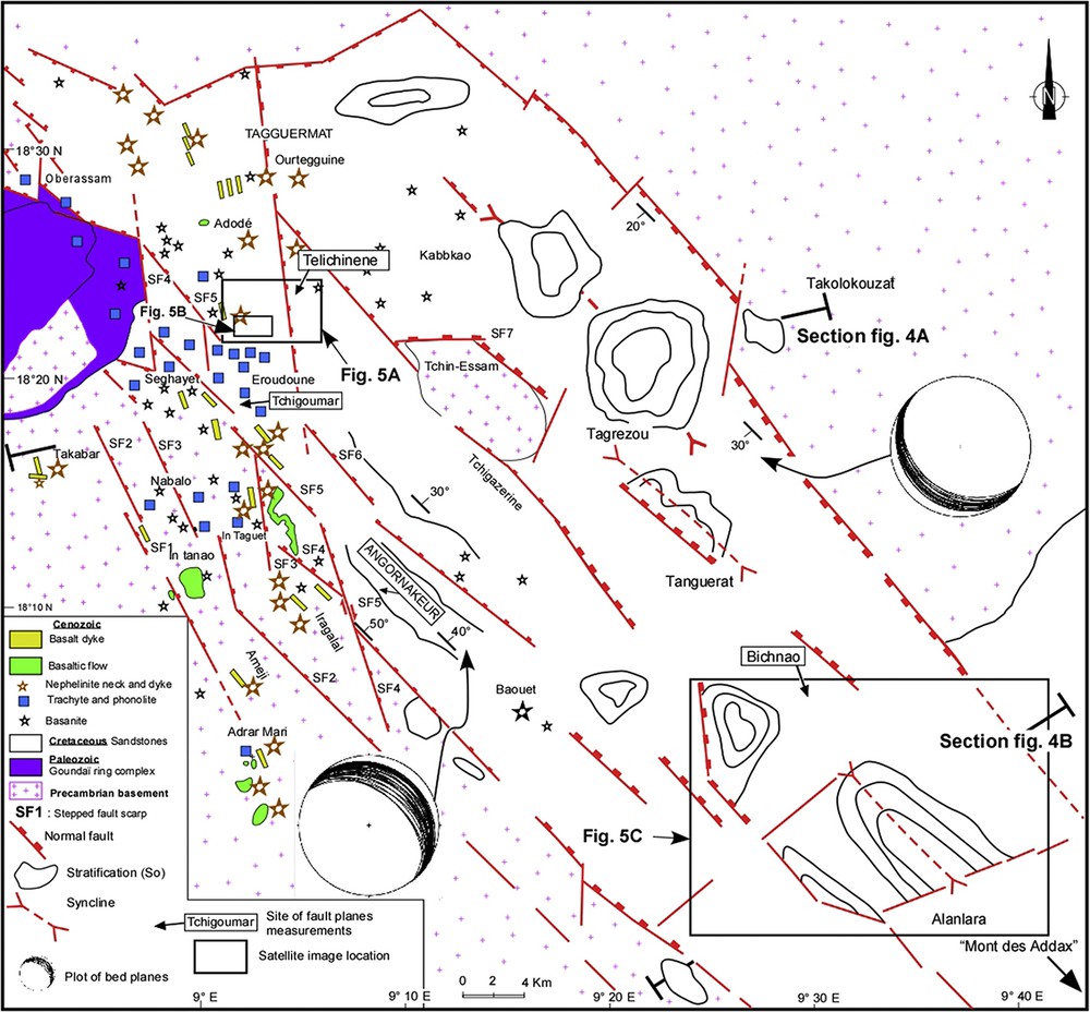
Structural map of the Téfidet trough (Ahmed et al., 2016, modified), showing synform structures in the Cretaceous formations of Téfidet basin affected by post-sedimentary faulting. Cross sections lines are indicated as well as the satellite images location.
Towards the northwest of the trough, the thickness of the various deposits decreases overall, so that, at some places, only the Lower Cretaceous sediments are present, forming thin shreds, sealed by Cenozoic volcanic edifices.
In the southwestern part of the trough, the infilling from bottom to top is as follows.
- - (1) About 600 m of “Téfidet Group” sediments. Those, Albian–Aptian in age, are the equivalent of the “Continental intercalaire” sediments in the Tim Mersoï basin in Niger (Fig. 1) (Meister et al., 1994). The Téfidet Group is made up of three formations (Fig. 2):
- • the Angornakeur Formation (250 m in thickness on average): it lays in angular unconformity onto the Precambrian basement. The sequence begins with beige to pink soft coarse sandstones and is followed upward by fine-grained and variably argillaceous sandstones. The beds may be conglomeratic or at some places feldspathic with cross stratifications. According to Faure (1966), this formation contains Dadoxylon-type silicified wood;
- • the Tagrezou Formation (150 m in thickness on average): it combines thin clay and sandy facies with vertebrate bones in calcareous-rich levels. It is the equivalent of the fossiliferous (dinosaurs, crocodilians …) Gadafaoua and Elrhas lacustrine sediments of the Iullemmeden basin in Niger (Fig. 1) (Faure, 1966).
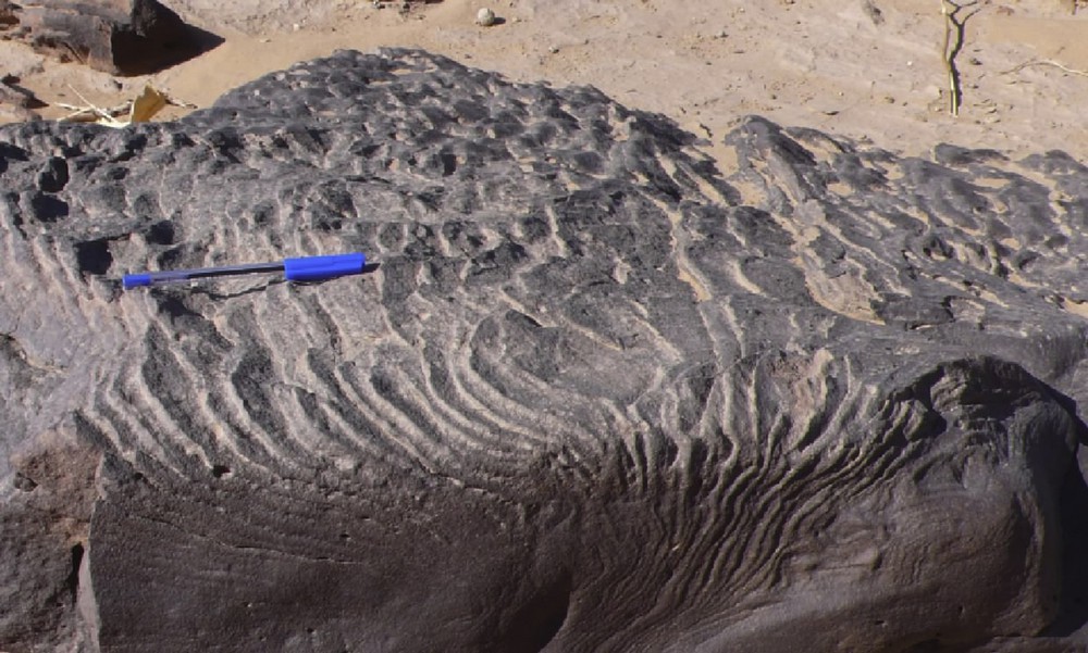
- • the Tanguerat Formation (200 m in thickness on average): it consists of middle-to fine-grained sandstones, either beige pink or reddish, with cross or overturned stratifications at some places associated with hydroplastic deformations (Fig. SM1).
- - (2) The Alanlara Formation (200 m in thickness on average), Lower Cenomanian in age (Faure, 1966), begins with black limestones containing lamellibranch debris, then beige to yellow fine-grained sandstones, clay–limestone silts, and ends with gastropod-rich sandy limestones. This formation, known as the Ezerza–Cheffadène Formation, makes the transition between the Tegama Group and the overlying marine deposits (Meister et al., 1994).
- - (3) The Cenomanian–Turonian series (70 m on average) consist of grey, pink to black fossils-rich limestones (Faure, 1966) including ammonites (Nigericeras, Neolobites), gastropod and lamellibranch debris (Exogyra olisiponensis). This level, known as the Zoo Baba–Arentigué formation (Faure, 1966), includes also green gypsum-bearing shales with oysters and sea urchins (Cidaris taouzensis).
From the Upper Cenomanian, the Ténéré ammonite faunas show a strong similarity with those of Northeast Nigeria. This similarity suggests that the Ténéré megasystem and the Nigerian Benue trough were connected in the Cenomanian–Turonian period (Meister et al., 1994).
3.2 Téfidet trough structural evolution
3.2.1 Available gravimetric data
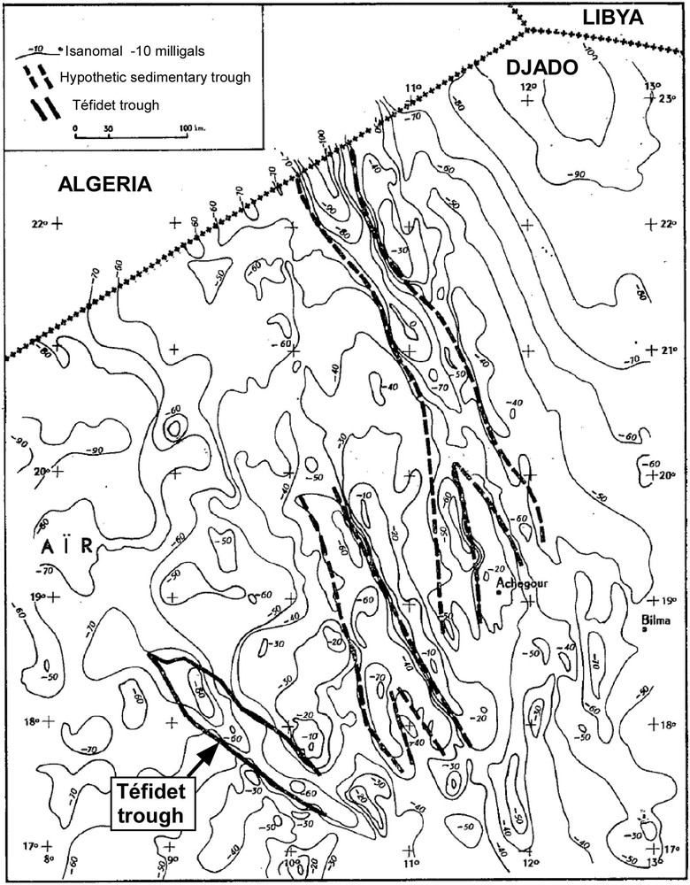
The N140° trend of the Téfidet trough is well revealed in gravimetric data (Louis and Rechenmann, 1966; Fig. SM2). These data show alternating strips of positive and negative anomalies, interpreted as uplifted (positive anomalies) and subsiding rock blocks (negative anomalies) bounded by normal faults. The negative gravimetric anomaly associated with the North Téfidet trough extends further towards the southeast, revealing the continuity of the trough over a length of at least 130 km under the Quaternary sand deposits. The gravimetric data also reveal the width of the trough, of about 40 km (Louis, 1970; Louis and Rechenmann, 1966; Pouclet and Durand, 1983), and confirm the total thickness of the sediment infill, ∼900 m.
3.2.2 Tectono-sedimentary analysis
Field observations are combined with satellite images to analyse tectonic and sedimentary features that range from decametric to kilometric scale. According to the relationships of the different structures observed (faults, fractures, folds) with sedimentation, we have distinguished in the Aptian–Albian and the Upper Cretaceous deposits syndepositional and post-depositional deformation structures. The syndepositional tectonic markers are progressive unconformities, layers thickness variations on both sides of the fold axes or the fault planes, and sometimes faults or fractures sealed.
Fig. 3 highlights the composite structure of the Téfidet graben, delimited by kilometric-scale N140°-trending major normal faults that bound the major or secondary grabens or horsts, and are associated with synforms structures affecting Cretaceous deposits.
The fact that the axes of the anticlines with sigmoidal shape are almost parallel to the direction of the N140° faults suggests that they are closely linked to the strike-slip component of the N140°-trending faults displacement. The N140° trending syn-deposition structures (faults and synforms) are offset by the post-sedimentary N10° to N170° strike-slip faults (Fig. 3).
To better understand the spatial arrangement of the Téfidet trough infilling, we have realized two structural cross-sections (Fig. 4), which are located in the southern part (Fig. 3, section Fig. 4B) and in the central part of the Téfidet trough (Fig. 3, section Fig. 4A). These structural cross-sections show that the Téfidet trough is a graben-shaped basin in which the sedimentary infilling is deformed into an asymmetric syncline associated with progressive unconformities.

(A): Synoptic geological section of the northern part of the Téfidet Trough, where Lower Cretaceous is sealed by Cenozoic volcanic edifices and affected by normal faults. In the Tchigoumar sector, the structural data plotting highlights a transtensional regime during the Lower Cretaceous with a ∼N130° trending shortening and a ∼N60° trending stretching and also a transtensional regime with nearly the same trending shortening and the same trending stretching. (B): Synoptic geological section of the southern part of the Téfidet trough highlighting the synsedimentary syncline structuration associated with progressive unconformities. In the sector of Bichnao and Alanlara (Fig. 3), the fault planes projection onto the stereographic diagram exhibits a transtensional regime with a ∼N140° trending shortening and a ∼N60° trending stretching.
The fault kinematics are defined by deduction of the sense of movement by using slickenside features such as gouge trails, tension gashes, Riedel fractures, secondary synthetic fractures, spoon-shaped depressions. This approach led us to separate three sets of faults, calibrated chronologically, according to their relationships with sedimentation. Then we projected the different population of fault planes separately onto the stereographic diagram (Stereonet10, Allmendinger, 2017). Their calibration and plotting permit to distinguish three main deformation phases (Fig. 4): the first one corresponds to the Aptian–Albian deformation phase (Fig. 4A), the second one is related to the Upper Cretaceous deformation event (Fig. 4B), and the third phase is linked to the Cenozoic tectonics regime (Fig. 4A).
- (1) Structures formed during the Aptian–Albian deformation phase
Satellite image data analysis
We identified, mapped and characterized fractures and faults by examining ground breaks and scarps in the Google Earth imagery. However, caution must be taken in interpreting the results, as many faults are presently eroded and hence cannot be detected. Our study areas concern the sectors of Telichinene and Bichnao (location in Fig. 3).
The satellite image of the Telichinene sector (18°25′59.24″N, 9°1′41.84″E and 18°22′46.15″ N; 9°6′6.79″ E; location in Fig. 3) shows a large number of fractures and faults, from hectometric to kilometric scale, that we have drawn in Fig. 5. Two kinds of faults and fractures have been distinguished, on the one hand, N170°- to N0°-trending normal faults and fractures, responsible for the Lower Cretaceous layers thickness and dip variations (Fig. 5A) and, on the other hand, N70°- to N100°-trending fractures that are sealed by the uppermost levels of the Lower Cretaceous (Fig. 5B).
- • On the satellite image of the Telichinene sector (location in Fig. 3), it can be seen that the combination of the large-scale N80° trending dextral strike-slip fault and the N140° trending sinistral strike-slip fault (Fig. 5B) are associated with the thickness variations of the intermediate Lower Cretaceous layers. This observation suggests the activation of these strike-slip faults during sedimentation.

Google Earth images showing progressive unconformities of Lower Cretaceous layers in the vicinity of N170°-N10° fractures (A), N70°–N100° fractures (B) and exhibiting syn-sedimentary synclinal structures in the Bichnao and Alanlara areas, which overlay within unconformity on the medium layers (C).
In addition, the satellite image of the Telichinene sector shows that locally the tilted lower deposits, which are associated with progressive unconformities, are sealed by the upper deposits.
Field data analysis
In the Tchigoumar sector (location in Fig. 3), the middle Angornakeur fine-grained sandstone to siltstone formation layers are affected by two types of anisopachous open folds, suggesting a waterlogged ductile deformation:
- • the first types of folds display a sigmoidal antiform axis and are almost parallel to the N140° major border fault (Fig. 6A). According to Guiraud (1993), folds with sigmoidal axes are related to an increase in the rate of strike-slip displacement. In the hinge zones, elliptical lenses, disposed obliquely to the strata, have been considered as deformation markers in the Tchigoumar sector (Fig. 6A);
- • the second type has N25° trending axis on average, plunging 25° towards SW. The folded layers show variations in thickness and amplitude on both side of the fold axis.
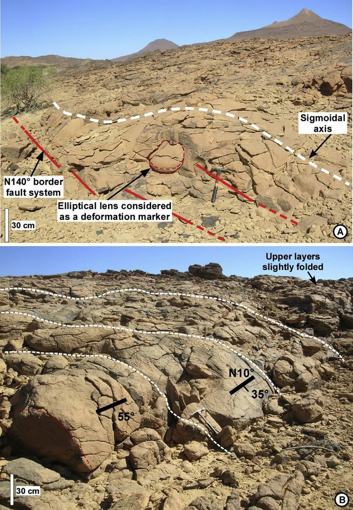
Multi-hectometric to decametric anisopachous folds: (A) with sigmoid axis N130° trending on average; in the hinge zones, an elliptical lens, disposed obliquely to the strata, has been considered as a deformation marker; (B) with axis N10°–25° plunging 35°–55° to the south (sector of Tchigoumar).
It is a multi-decametric asymmetric fold exhibiting thickness variations on the both sides of its axis. Vertically, we can observe an attenuation of folding associated with a gradual decrease of the layers' dipping.
In the area of Telichinene (Fig. 5A) the bevel pattern of the layers in the close vicinity of the submeridian normal faults (N0°–N170°) exhibits many progressive unconformities, in the lower Cretaceous intermediate layers, from decametric to hectometric scale (Fig. 5A and B).
Along the western border of the trough, in the Angornakeur sector, the Lower Cretaceous layers are tilted about 40–50° to the northeast. More than 50 bed planes are measured on each side of the trough and plotted (Fig. 3).
In the Angornakeur sector (location in Fig. 3), the uppermost Lower Cretaceous deposits are affected by decametric to hectometric scale reverse faults having strike-slip component, north–south to N10° trending with 50°–20° dip to the southeast (Fig. SM3). These reverse faults induce thickness variations of the sandstone levels, associated with displacements attenuation towards the top. These faults are sealed by the upper sandstone layers (Fig. SM3).
In the Tanguerat sandstone Formation (southern part of the Téfidet trough, location in Fig. 3), our field observations revealed metric scale hydroplastic deformations (see Fig. SM1), which we consider as syndepositional features.
Plotting faults planes associated with this deformation phase onto the stereographic diagram (Stereonet10, Allmendinger, 2017) show an N50N60° extension direction combined with a sinistral displacement of the N140° to N170° trending major faults, evidencing a transtensional regime (Fig. 4A). We believe that all these structures characterize the first period of rifting that prevailed during the period ranging from Aptian to Albian.
- (2) Structures related to the Upper Cretaceous deformation phase
In the Téfidet trough, Upper Cretaceous deposits are transgressive on the Albian–Aptian continental formations. A major change in the palaeogeographic setting occurred during the Cenomanian, with marine incursions into the Niger and Chad basins (Liu et al., 2015). The lowermost deposits of Upper Cretaceous are well preserved in the southern part of the Téfidet trough in the Bichnao sector (localization in Fig. 3).
In this sector, we have observed an asymmetric synsedimentary synformal basin (Fig. 5C) (about 2–8 km in length and 2–16 km in width) that affected Upper Cretaceous deposits. At the regional scale of the Téfidet trough, we have identified about ten synform structures in the centre of the trough and along its eastern edge (Figs. 3, 5C and 4B). One can note that the folds tend to be restricted to the axial parts of the basin (Fig. 3).
The synsedimentary nature of the synclinal structure, observed on the Bichnao sector satellite image (18°6′1.16″N; 9°37′40.01″E and 17°52′0.83″N; 9°48′39.52″E), is marked by the strong thickness variations of Upper Cretaceous layers on both sides of the synclinal axis, associated with a fan arrangement of the layers.
Field observations show that in both the main graben of the Téfidet trough and the secondary ones, the Cretaceous layers dip evolves from 30 to 40°on the western edge to about 10–20° on the eastern border (Fig. 4B). These progressive variations of the layers dip are related to the syndepositional normal to transtensional activation of the NW–SE-trending faults.
Analysis of fault geometries, fault kinematics, and sedimentation patterns indicates that the southern part of the study area is composed of a segmented fault pattern with 40° to N80° striking strike-slip and N130°- to N170°-trending normal faults (Figs. 3 and 5C).
The plotting of the fault planes onto the stereographic diagram (Fig. 4B) shows the prevailing of the transtensional regime with the same direction of extension (N60–N70°) and shortening (N140–N150°).
According to these observations, we assume that this second phase of deformation is related to the rifting episode that affected the Téfidet trough during the Upper Cretaceous period.
- (3) Cenozoic deformation phase
In the Téfidet trough, the rifting ended at the end of the Upper Cretaceous period. During the Cenozoic, the recovery of the tectonic activity is marked, on the one hand, by the deformation of the Cretaceous sandstone (flexures, folds, faults, fractures) and, on the other hand, by a fissural alkaline volcanism.
To investigate the Cenozoic deformation phase, we have established a relative chronology between fractures, faults, and dykes. Many surface structural features interpreted from satellite images suggest that sinistral strike-slip deformation superimposed and offset the prior rift basin.
The dykes have a mean direction of about N140° and a dip of 75° SE. The stereoplot of the normal and transtensional faults measured indicates an average direction of extension of ∼N70° (Fig. 4A), which is compatible with the ∼N140° orientation of the dykes. Observing the geometric relationships between sandstones, basaltic dykes and microfracturing allowed dating the fracturing episode associated with volcanism. The strong concordance of the fracture directions with the dykes trending confirms the idea of a synchronism between the ∼N140° fracturing and the emplacement of the basaltic dykes.
4 Discussion
The Téfidet trough is a part of a large-scale system of Cretaceous to Tertiary NW-trending rift basins, which extend into Libya (Abdunaser and McCaffrey, 2015; Van Houten, 1983), in Tunisia (Boutib et al., 2000), southeastern Niger (Genik, 1993; Harouna and Philip, 2012; Liu et al., 2012; Wan et al., 2014) Nigeria, Chad, and Sudan (Genik, 1993; Mohamed et al., 2001; Yassin et al., 2017).
The basins in North Africa and in the West and Central African Rifts System (WCARS) have a thickness ranging from 1000 to 10 000 m (Yassin et al., 2017). The sedimentary infilling is made of marine formations. By contrast, the sediment thickness is thinner in the Téfidet trough, and consists of fluvio-lacustrine deposits (Fig. 2). The Cenozoic series that are most present in the Cretaceous basins of North Africa and of the West and Central African Rifts System are absent in the Téfidet trough. Some of the basins, such as those of Syrt in Libya (Abdunaser and McCaffrey, 2014, 2015), Termit–Agadem in Niger, Bornu in Nigeria, Doba and Bongor in Chad, and Muglad in Sudan (Adegoke et al., 2014; Alalade and Tyson, 2010; Mohammed et al., 1999; Obaje et al., 2004) contain hydrocarbon deposits, unlike the Téfidet trough, not deep enough.
Despite the above differences, the Téfidet trough shows important similarities with the Cretaceous basins of Tunisia, Libya, and those of the West and Central African Rift system:
- - it is a rift basin type with the same NW–SE trend as those basins (Syrt, Gargaf, Termit–Agadem, Bongor, Doba);
- - the first deposits in the Téfidet trough, Albian–Aptian in age, are contemporaneous with the initial stages of the opening of the southern Atlantic Ocean.
Basins of WCARS share a similar evolution history as they were developed in a similar overall tectonic setting. However, individual basins may have their own histories and structure due to their specific locations and orientations in relation to the regional tectonic stress fields (Yassin et al., 2017). For instance, while one basin is subjected to an extensional regime, another basin with a different orientation might be subjected to strike-slip movements (Fairhead et al., 2013).
The basins in the WCARS are arranged in three main orientations, NE–SW (BenueTrough in Nigeria), ENE–WSW (Doba, Doseo, Salamat basins in eastern Chad and Baggara Basin in western Sudan), and NW–SE (Muglad Basin in Sudan, and Ténéré rift system in Niger) (Genik, 1993; Yassin et al., 2017).
The early stage of the opening of the Atlantic Ocean occurred during the period ranging from the Neocomian to the Barremian (about 130–123 Ma) (Fairhead et al., 2013; Guiraud and Bosworth, 1997; McHargue et al., 1992; Mohamed et al., 2001; Schull, 1988). This stage, governed by a north–south crustal extension or transtension (Fairhead et al., 2013; Guiraud and Bosworth, 1997), has not been registered in the Téfidet trough, whose lowermost deposits are dated from the Aptian to the Albian. So, we can consider this first north–south Cretaceous crustal extension stage as a pre-Téfidet extensional event.
In the Téfidet trough, syn-rift faulting started in the Aptian. The Lower Cretaceous continental sequences, reaching thicknesses of 600 m, were deposited in grabens controlled by N120°- to N140°-striking normal to strike-slip faults. The analyses of these synsedimentary normal and strike-slip faults suggest that the rifting in this area resulted from a NE–SW extensional to transtensional regime. The lowermost continental deposits were followed by Upper Cretaceous marine siliciclastics, shales, and carbonate rocks.
During the Upper Cretaceous, a number of basins (e.g., Salamat, Doba, Doseo (in Chad), and Baggara (in Sudan)) uplifted, due to their favourable orientation with respect to the NW–SE compressional stresses, and were exposed to erosion (Yassin et al., 2017).
This was not the case of the Téfidet trough, however. As proposed by Mc Hargue et al. (1992), this might be because the Téfidet trough and the Muglad basin (in Sudan) were sub-parallel to the shortening direction. In that framework, the decrease of the Téfidet trough infilling (less than 300 m) during the Upper Cretaceous period is thought to be related to a decreasing subsidence rate.
In the Téfidet trough, this transtensional to extensional period is marked by the ongoing activity of the major normal N140° border faults and by the formation of strike-slip structures. The Téfidet trough infilling ended at the end of the Upper Cretaceous period.
The Paleogene period is marked by the closure of the Téfidet basin. The Palaeocene–Eocene period is characterized by the most intense collision along the Alpine orogenic belt (Fairhead et al., 2013; Guiraud and Bosworth, 1997; Yassin et al., 2017). This collision exerted a strong influence on the development of the Africa interior basins (Yassin et al., 2017) such as the Téfidet trough.
During the Paleogene period, the Téfidet trough was marked by a fracturing episode associated with magmatic activity. Unlike the South Termit, which is the southern extension of the Téfidet trough, these magmatic episodes were not associated in the Téfidet Trough with a subsidence and with a recovery of sedimentation.
This transtensional regime could have taken place in two contexts: the Tuareg shield uprising and the NW–SE shortening linked to the Africa–Europe collision (Ahmed et al., 2016; Liégeois et al., 2005; Wilson and Guiraud, 1992).
5 Conclusion
The tectono-sedimentary evolution of the Téfidet trough was marked by three periods: two rifting stages (during the Early Cretaceous and the Upper Cretaceous) and a post-rift stage (during the Cenozoic).
The first rifting stage, Aptian-Albian in age, shows a general continental sequence composed from bottom to top by coarse sandstones, shales and middle sandstones. It was characterized by a low subsidence rate with an infilling that reached 600 m. It was dominated by an extensional to transtensional tectonic regime, characterized by an ENE–WSW trending stretching associated with a strike-slip regime, which produced a variable sediment thickness and facies distribution during the Aptian–Albian times.
The second period, ranging from the Cenomanian to the Turonian (Upper Cretaceous), corresponds to a short episode of transtensive to extensive tectonics regime, with nearly the same stretching and shortening direction as at the first stage. However, this period was characterized by a marine incursion that deposited siltstones, limestones and sandstones. It was marked by a very low subsidence rate with an infilling less than 300 m.
The third period, related to a post-rift stage, dated back from the Cenozoic, corresponds to an episode of renewed transtensional and extensional tectonics. Unlike the previous periods of rifting stage, the transtensional to extensional tectonics regime was here accompanied by volcanic activity and fracturing.
Unlike the other WCARS equivalent basins, the geodynamic evolution of the Téfidet trough is marked by the persistence of transtensive tectonics. The NE–SW to ENE–WSW extension that affected the trough for a long time might have been induced by the NW–SE crustal shortening that occurred during the Cretaceous to Cenozoic times. A continuum of that transtension can be evoked as, since the first stages of rifting up to the closing of the Téfidet trough during Upper Cretaceous, the context did not change, even during the Cenozoic.
Due to the Tuareg shield uprising and the NW–SE shortening linked to Africa–Europe collision, the Tefidet areas were uplifted or remained high during the Cenozoic period. This pattern impacted the evolution of the Téfidet trough, which apparently did not subside during the Cenozoic.
This study shows that the singular position of the Téfidet trough between the North African and the West and Central African Cretaceous equivalent rifts makes it a critical target zone for the tectono-sedimentary analysis of the WCARS. So, this analysis is a contribution to a better knowledge of the structural evolution of the Téfidet trough during the Cretaceous–Cenozoic period in the framework of the West African Cretaceous and Paleogene rifting.
Acknowledgements
The authors greatly acknowledge Prof. Isabelle Manighetti for her helpful remarks and her careful reviewing. The authors are grateful to Prof. Jean-Paul Liégeois for his helpful reviews and comments.
Appendix A Supplementary data
The following are the Supplementary data to this article: