


 CC-BY 4.0
1. Introduction
The late Carboniferous–Permian is a period of large-scale geodynamic reorganization, (i) with the final accretion of Pangea (Variscides/Mauretanides/Alleghenides orogeneses) and the beginning of its breakup (NeoTethys opening) [e.g., Domeier and Torsvik 2014; Scotese and Langford 1995; Stampfli et al. 2013], coeval with (ii) the acme of the Late Paleozoic Ice Age (LPIA), constituting a turning point in the climate regimes of the Paleozoic [e.g., Gastaldo et al. 1996; Montañez et al. 2007].
From the end of the Carboniferous onwards, the over-thickened and hot Variscan crust collapsed [late-orogenic collapse; Burg et al. 1994; Faure 1995; Malavieille et al. 1990; Ménard and Molnar 1988; Van Den Driessche and Brun 1992], triggering the rise of high-grade metamorphic domes along low-angle detachment faults, and the development of half-graben or pull-apart multi-directional intramountain coal basins [Costa and Rey 1995; Gardien et al. 2022; Malavieille 1993; McCann et al. 2008a, b; Ménard and Molnar 1988; Van Den Driessche and Brun 1989].
These late orogenic Carboniferous–Permian basins (hereafter LOCPB) therefore widely developed around 300 Ma in the internal parts of the belt south of the northern Variscan Front. They crop out in several limited locations in and around the Variscan basement of western Europe (Pyrenees, Massif Central, Brittany, Vosges-Black Forest, Alps, Harz), in close genetic relationships with major Variscan tectonic structures (e.g., Sillon Houiller, South-Hunsrück Fault; Figure 1 and related references).
Map of NW European outcropping and subsurface LOCPB; compiled from Beccaletto et al. [2015], BRGM [1984, 1989, 2003], Delmas et al. [2002], Gast et al. [2010], Schäfer and Korsch [1998], Schneider and Romer [2010], Schneider and Scholze [2018]. Numbers—French outcropping LOCPB: 1: Carentan/Littry; 2: St-Pierre-la-Cour; 3: Doué-la-Fontaine; 4: Sillon Vendéen, Chantonnay, Faymoreau; 5: Villé; 6: St-Dié; 7: Ronchamp-Giromagny; 8: Autun; 9: Decize La Machine; 10: Blanzy-Le Creusot; 11: Bert; 12: Aumance; 13: Commentry, Doyet, Deneuille; 14: Ahun; 15: Bosmoreau-les-Mines; 16: Bassins du Sillon-Houiller; 17: Brive; 18: Brassac, Brioude; 19: St-Etienne; 20: Prades-Jaujac; 21: Alès; 22: Graissessac, Lodève; 23: St-Affrique; 24: Figeac, Decazeville, Rodez; 25: Quercy-Albigeois, La Grésigne; 26: La Rhune-Bidarray; 27: Ossau; 28: Var; 29: Barrot, Argentera; 30: Alpes zones externes; 31: Alpes zones internes. Italic letters—Other West European LOCPB A: Albersweiler; BI: Bifertengrätli; BR: Breisgau; EN: Entlebuch; FR: Frankenberg Bay (Naab—Weiden); IF: Ilfeld; K: Kraichgau (Baden-Baden); LO: Lombardian; MF: Manx-Furness; NSW: North Switzerland; S: Saale (Halle); SCH: Schramberg; SNB: Saar-Nahe; RS: Ries-Salzach; S: Sudetic; SD: Salvan-Dorenaz; ST: Stockheim; TF: Thuringian Forest; VFD: Variscan Foredeep; W: Wetterau; WE: Wessex;WI: Wittlich Graben. Blue letters—Basement rocks A: Ardennes; Al: Alps; BF: Black Forest; BM: Bohemian Massif; Br: Bretagne; H: Harz; MC: Massif Central; Py: Pyrenees; SG: Schiefere Gebirge; V: Vosges. Sillon Houiller fault: SH; South Hunsrück Fault: SHF. Arpheuilles-1 well: Arph.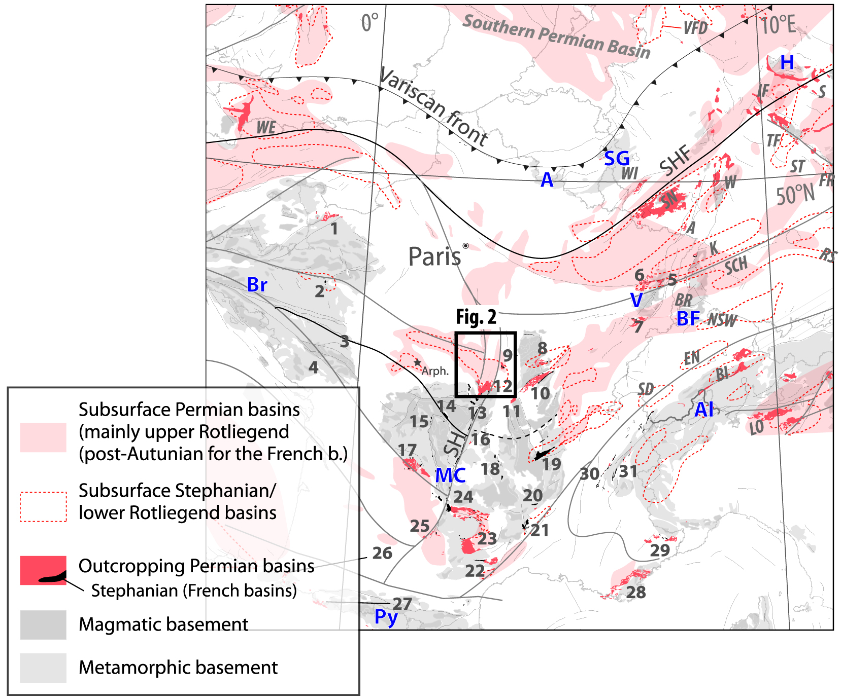
They were filled with siliciclastic volcanoclastic continental material—from alluvial to lacustrine through fluvial environments—at intertropical latitudes [Donsimoni 1990; Gand 2003; Mercuzot et al. 2021, 2022; Schäfer 2011; Schneider and Romer 2010; Soreghan et al. 2020]. LOCPB were also accompanied by widespread intrusive and extrusive magmatic activity with a crustal or mantle origin with mostly felsic and rare mafic signatures [Neumann et al. 2004; Timmerman 2004; McCann et al. 2006]. Apart from scientific research, LOCPB were extensively studied for their resources such as oil, gas, coal, uranium or other ore deposits [Bouchot et al. 1997, 2005; Courel et al. 1986; Delmas et al. 2002; Dill et al. 1991; Mascle 1990], and more recently for geothermal [Aretz et al. 2016] or natural helium [Hauville et al. 2021] purposes.
In map view, they occur as small isolated and disconnected “basins” with incomplete sedimentary successions and numerous sedimentation and erosional gaps [e.g., Schneider et al. 2020]. Their present-day area does not reflect their initial extent and thickness, which can be explored by studying their subsurface prolongation beneath the Meso-Cenozoic sedimentary covers [Beccaletto et al. 2015; Mercuzot et al. 2021; Schneider and Scholze 2018; Ziegler 1990]. These basins usually reach thicknesses of several kilometers like, for instance, in the southern French Massif Central [e.g., Lodève, Carmaux—La Grésine; BRGM 1989] or central Europe [e.g., Saar-Nahe and Thuringian Forest basins; Schneider and Romer 2010]. Generally speaking, the ages of the LOCPB broadly range from Gzhelian to Guadalupian encompassing the Stephanian, Autunian, lower Rotliegend and part of the upper Rotliegend western European stages [ca. 303 Ma to ca. 270 Ma; e.g., Ducassou et al. 2019; Michel et al. 2015; Lützner et al. 2020; Opluštil et al. 2016; Pellenard et al. 2017; Poujol et al. 2023; Voigt et al. 2022].
One recurrent question that arises from the study of the LOCPB is based on sedimentological, structural and temporal criteria: what are their regional correlations and extents? The answer to this question calls for the recognition of reference basins with enough useful data to make correlations. On one hand, recent advances in their age calibration using radiochronological methods have led to improved inter-basin comparisons [e.g., Ducassou et al. 2019; Mercuzot et al. 2023; Opluštil et al. 2016; Pellenard et al. 2017; Schneider et al. 2020; Voigt et al. 2022]. On the other hand, fewer significant works have been carried out recently on their structural pattern and tectonic evolution [Beccaletto et al. 2015, and references therein], and therefore the poor understanding of their tectonic framework limits their comparison at local or regional scales.
One good way to discuss the tectono-sedimentary history of hidden subsurface LOCBP is to use seismic data to look for them under their Meso-Cenozoic sedimentary cover given that they may be considered as fossil basins with preserved pre-Triassic depositional and structural patterns. We present new results from the interpretation of industrial seismic lines spanning 115 kilometers, while targeting the Brécy depocenter in the southwest Paris Basin, which has recently been reprocessed within the framework of an International Continental Scientific Drilling Program proposal [ICDP Deepdust project; Soreghan et al. 2020]. First, we aim to discuss the structural features, thickness and tectonic evolution of the Brécy depocenter and the related sedimentary filling using seismic and well data. Last, we compare and propose correlations between the Brécy depocenter and other Carboniferous–Permian deposits in the northern Massif Central, as well as other places in France and Germany.
2. Geological setting of the Brécy depocenter
The Brécy depocenter is one of the three several-kilometer-thick depocenters recently revealed by the interpretation of reprocessed vintage seismic lines in the southwestern part of the Paris Basin [together with the Contres and Arpheuilles depocenters; Figures 1, 2; Beccaletto et al. 2015]. It has a roughly elongated shape striking N30 parallel to the northern trend of the Sillon-Houiller fault zone. The opening of the basin was thought to be controlled by the activity of several N030-trending normal faults accommodating the deposition of the Stephanian-Permian deposits which have estimated thicknesses up to 3000 m.
Geological map of the study area depicting the Brécy depocenter and adjacent LOCPB, the location of the reprocessed seismic lines, and deep wells. The geological background is from the 1:1,000,000 geological map of France [BRGM 2003].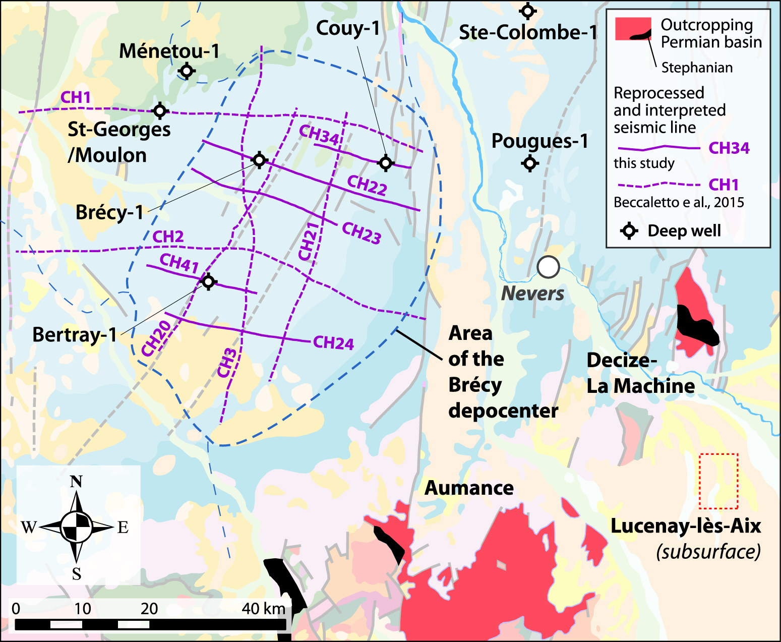
The age of the Carboniferous–Permian series in the Brécy area comes from the description of the Bertray-1, Brécy-1 and Saint-Georges-sur-Moulon-1 well cuttings (from drilling reports; hereafter called the BTY1, BRC1 and SGS1 wells, respectively; Figure 2), and from palynological data from the core of the scientific Couy-1 well [Orszag-Sperber et al. 1992; hereafter COU1; Figure 2].
In the COU1 well, the sedimentary succession, attributed to the Permian based on the presence of several Darwinulacea ostracods [Orszag-Sperber et al. 1992], is composed of approximately 250 m of mainly red silty-clay sediments with sandstones and few conglomerates at the base. This succession describes a general trend from alluvial fan to shallow lake deposits; neither tonstein (volcanic ashes transformed into clay minerals) nor palynological data exist to shorten the age range [Juncal et al. 2018]. In this area, the Permian deposits end with the Triassic unconformity, overlain by middle Anisian deposits [Early and early-Middle Triassic gap; Bourquin et al. 2006; Juncal et al. 2018].
In BTY1, from 2963 m to 2842 m, the sedimentary succession is mainly composed of black-gray silty-clay interbedded with detrital coal, sandstones and conglomerates. The age is attributed to the late Carboniferous based on: gastropods and ostracods from the Carbonita genus found in the calcareous level at the base, bisaccate pollens at 2963 m and the presence of Lycospora pellucida and Florinites junior pollen at 2850 m [Bertray1 1987].
In BRC1, below 1806 m, the facies are more carbonated with argillaceous-dolomitic limestones interbedded in fine-grained gray-green argillaceous sandstones. Between 1802 m and 1806 m, plant fragments suggesting a Carboniferous age [Brécy1 1966] have been found in micaceous silty-claystone.
The drilling of the SGS1 well has reached a Paleozoic succession from 1639 to 1878.3 m attributed to the Cambro-Silurian by comparison with known facies in outcrops in the Massif Central [St. Georges-sur-Moulon1 1964].
In COU1, the basement, composed of metamorphic rocks, starts at a depth of 941.65 m. It is overlain by a highly tectonized Paleozoic sedimentary series [Lorenz et al. 1987] until 925.35 m. The Paleozoic upper part is composed of volcanoclastic deposits attributed to the Stephanian [Chantraine et al. 1992]; trachy-andesites sampled at the bottom of the Stephanian unit (925.35 m and 941.65 m) yielded an Ar–Ar plateau age of 301.6 ± 6.3 Ma [Costa and Maluski 1988]. The Stephanian volcanoclastic unit is overlain by Permian fluvio-lacustrine deposits above an angular unconformity [Lorenz et al. 1987].
3. Material and methods
3.1. Seismic data reprocessing
The present study is based on the reprocessing of five seismic lines representing approximately 115 km, acquired by the ESSOREP oil company in 1984 and 1985 (CHER survey, denoted as CH; Figure 2). This new dataset completes the ca. 200 km of vintage industrial seismic reflection profiles that were reprocessed and interpreted in the Brécy area in the initial study of Beccaletto et al. [2015].
Given the acquisition parameters used in these exploration surveys, mainly the frequency bandwidth of the seismic source and the recording length (up to 4 s TWT—Two-Way-Time), the estimated depth of investigation is roughly 7–8 km, with a vertical resolution of approximately 25 m and 30–35 m respectively in the shallow and deepest part of the lines. These vintage seismic data have been reprocessed using modern Pre-Stack time migration (PSTM) methods and algorithms, thereby significantly improving the quality of the resulting seismic section and providing enhanced descriptions of the geological structures [Beccaletto et al. 2011, 2015]. Efforts were focused on three key steps that were repeated several times throughout the processing unit: (a) computing primary and residual static corrections in order to remove the topographic and velocity effects of the superficial rock layer, strongly affecting the seismic signal; (b) detailed velocity analysis; and (c) various methods of organized and random noise attenuation. Pre-stack time migration enhanced the details of the structural features and completed this reprocessing unit before stacking the data [cf. Laurent et al. 2021 for another example of seismic reprocessing and interpretation in Carboniferous basins].
3.2. Seismic interpretation and well-data
In a first step, the seismic facies and reflector geometries were interpreted by using nearby wells to calibrate and tie the seismic lines for the main horizons. Unlike the previous regional study of Beccaletto et al. [2015], the BTY1, BRC1 and COU1 wells are located directly on some of the newly reprocessed seismic lines (resp. CH41, CH22 and CH34; Figure 2), thereby preventing any lateral projection bias. Once the targeted horizons were identified near the BTY1 and BRC1 wells (deepest wells), they were correlated step by step, from line to line, by comparing the seismic facies using the Gverse Geophysics module of the Gverse suite (© Landmark), and by checking their 3D structural consistency (using the 3D viewer of the interpretation software). Steps two and three correspond to the building of the structural scheme and the thickness map of the Brécy depocenter, respectively. In a fourth step, the electrofacies and depositional environments are described within the framework of the seismic interpretation by using subsurface well data such as: (i) the description of the cuttings from reports and well data (gamma Ray (GR), sonic or neutron, and resistivity) for the BRC1, BTY1, and SGS1 wells; and (ii) core description and complete well log data (GR, sonic, resistivity, density, photo electric factor (Pef), and neutron) for the COU1 well [Juncal et al. 2018]. In a last step, these four wells were correlated to give a lithostratigraphic and sequential framework to the Brécy area.
4. Results
4.1. Seismic interpretation, targeted horizons and seismic facies
Figures 3 and 4 display four examples of investigated seismic profiles in an uninterpreted and interpreted form. The main seismic features and units are discussed below from bottom to top.
W–E composite line CH41-20-2 and line CH24, interpreted and uninterpreted, depicting the main structural features of the Brécy depocenter; blue arrows: Meso-Cenozoic faults, black arrows Carboniferous–Permian and Meso-Cenozoic faults; see text for details.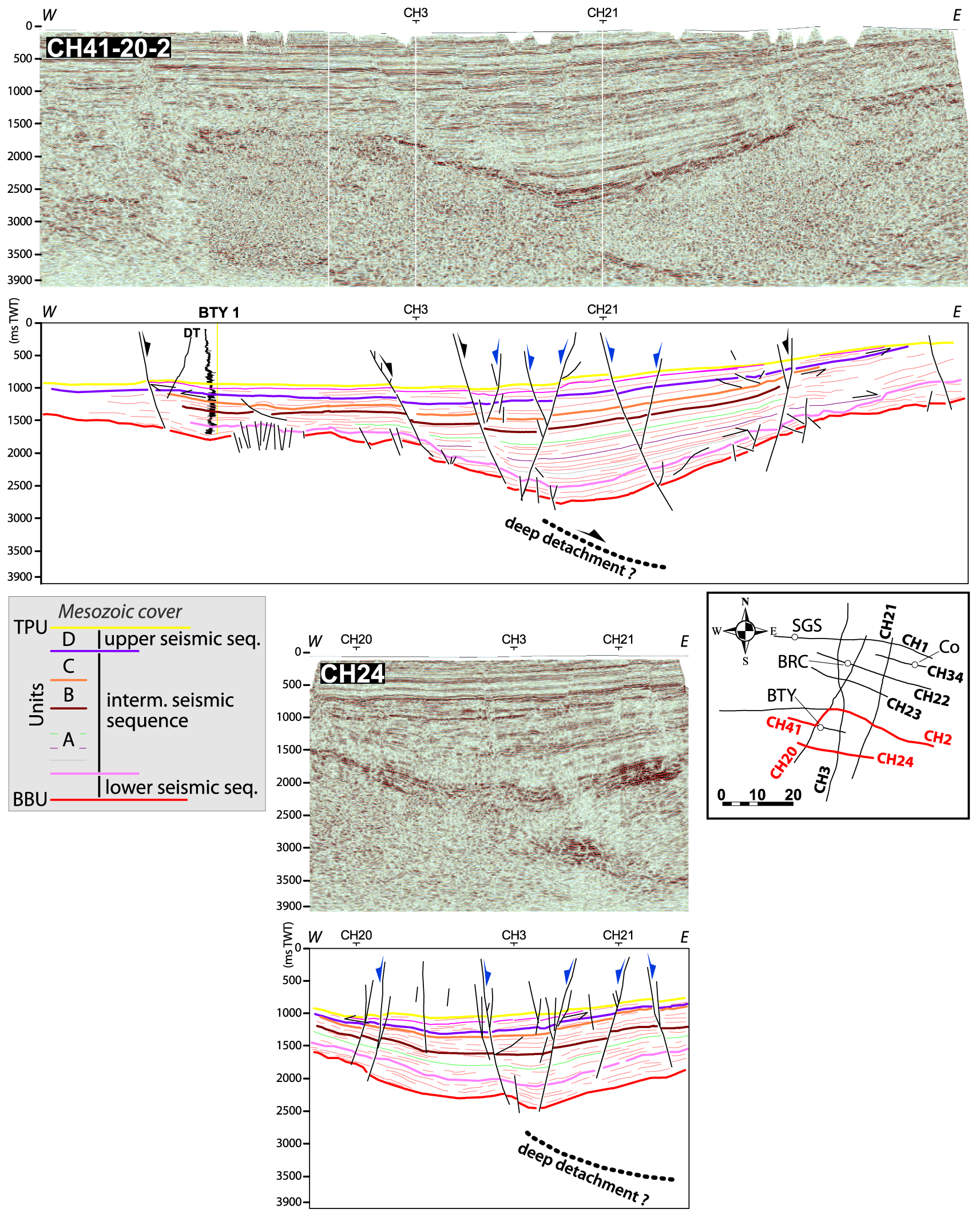
N–S line CH3 and line CH21, interpreted and uninterpreted, depicting the main structural features of the Brécy depocentre; blue arrows: Meso-Cenozoic faults, black arrows Carboniferous–Permian and Meso-Cenozoic faults; see text for details.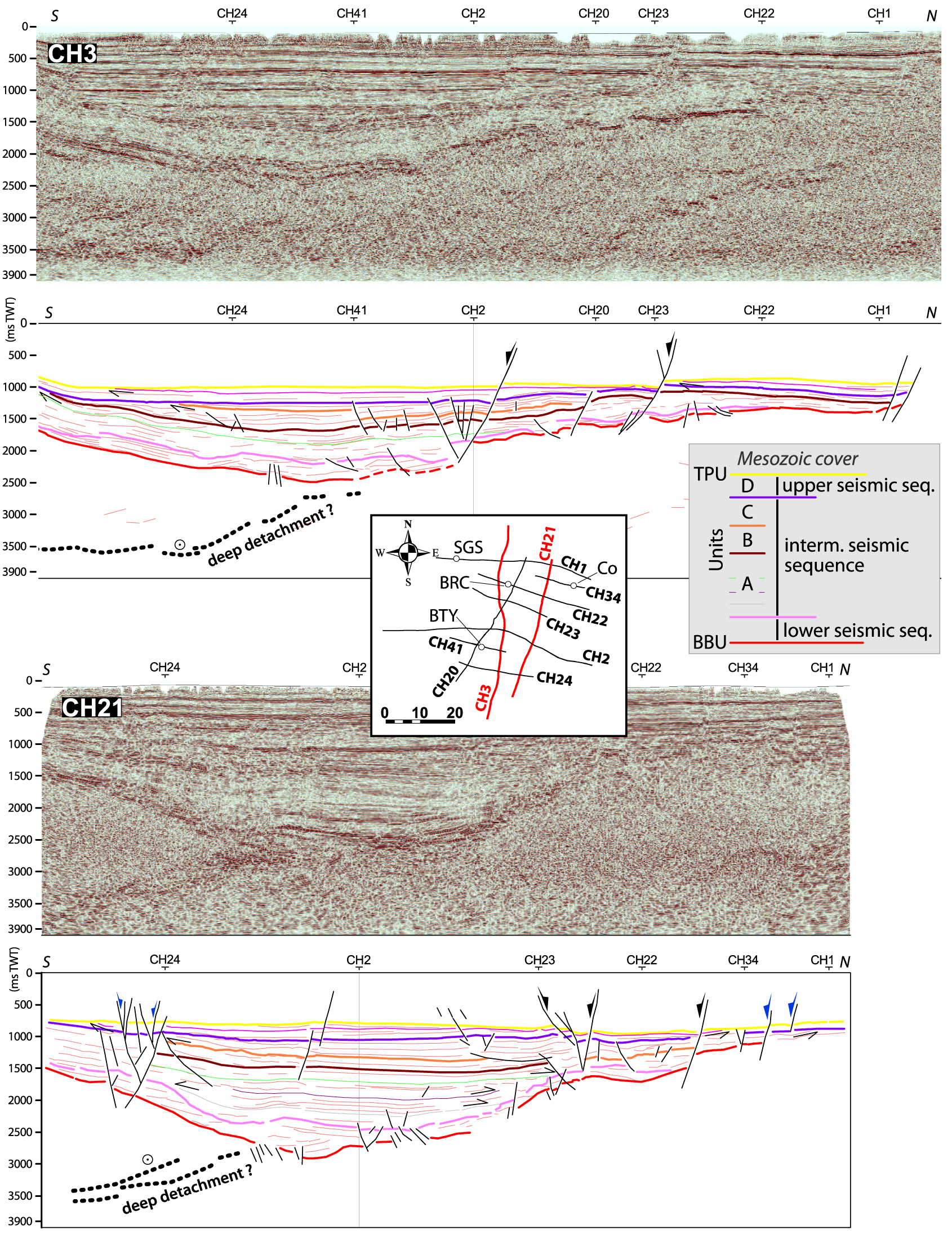
The base of the late Carboniferous–Permian sedimentary fill (Base Basin Unconformity—BBU) corresponds to the top of the pre-Stephanian substratum. The four wells in the Brécy area do not reach the substratum, however it is cut across by fifteen wells in the westward Contres and Arpheuilles depocenters. There, the substratum could be sedimentary, metamorphic or plutonic [Beccaletto et al. 2015]. In most places, the top of the pre-Stephanian substratum matches the top of the acoustic basement, where the seismic signal becomes chaotic. However, some sets of reflectors, belonging to pre-Stephanian units, still appear locally below the BBU (line CH3, Figure 4).
The end-Carboniferous–Permian deposits s.s. correspond to the seismic facies observed between the Top Paleozoic Unit (TPU) and the BBU. In general, they are stratified with an overall wedge-shape geometry slightly thinning eastward, and continuous reflectors varying from low to high amplitudes and medium to high frequencies; chaotic or semi-transparent facies are also possible. The topmost preserved Permian beds display toplap geometries below the TPU (Figures 3 and 4). However, in closer detail, it is possible to distinguish three seismic sequences:
- A lower seismic sequence with thicknesses less than 0.5 s TWT made of low-frequency/(very) high-amplitude, continuous to discontinuous reflectors; in the BTY1 well, these reflectors are correlated with Stephanian conglomeratic and coal beds, as seen in the Arpheuilles-1 well [Beccaletto et al. 2015];
- a much thicker intermediateseismic sequence (up to 2 s TWT) with lateral thickness variations in units A, B and C; in particular, note the thickening of unit A toward the center of the basin. These three units were deposited during normal fault activity and, as a whole, represent the syn-rift stage of the Brécy depocenter (cf. Section 5.1);
- a thinner upper seismic sequence, (less than 0.25 s TWT), made up of unit D, located just below the TPU; this unit does not display any thickness variations related to fault activity. The seismic facies are more transparent here than in the lower and intermediate units, certainly due to less contrasting lithologies (cf. Section 4.1). The horizons of the intermediate seismic sequence display a toplap geometry beneath the base of the upper seismic sequence, indicating an erosional phase in between. This upper seismic sequence represents the post-rift stage of the Brécy depocenter (cf. Section 5.1).
The Mesozoic sedimentary cover of the Paris Basin unconformably overlies the Permian Brécy deposits and consists of parallel to sub-parallel continuous reflectors with medium- to high-frequencies and alternating medium- to high-amplitudes related to lithological variations within the Triassic and Jurassic deposits. The reflectors gently dip northward towards the center of the Paris Basin.
4.2. Fault patterns and structural schemes
All seismic lines display normal faults, which are the norm in the Brécy depocenter; the vast majority of the faults developed during the Meso-Cenozoic, as suggested by the equal down-throw all along the fault plane both across the Carboniferous–Permian and Mesozoic strata (blue arrows in Figures 3 and 4). Some faults characterized by different thicknesses of Carboniferous–Permian deposits on both sides are expected to have controlled the late Carboniferous–Permian filling. The seismic lines do not clearly image the prolongation of these normal faults through the base of the basin downward to the acoustic basement (Figures 3, 4). Deeply seated reflectors located in the prolongation of eastward dipping normal faults may correspond to low angle normal faults (detachments; Figures 3, 4; cf. Section 5.1). These initial Carboniferous–Permian faults also display Meso-Cenozoic activity, as shown by the down-throw of the TPU and overlying Mesozoic strata (black arrows in Figures 3, 4).
The reprocessing and interpretation of the additional seismic lines make it possible to build a detailed structural scheme for the Brécy depocenter, greatly improving the spatial resolution of the structural pattern drawn by Beccaletto et al. [2015]. The present study leads to the recognition of seven “major” faults (i.e., with a large cartographic extent and usually cutting through several seismic lines), and eleven secondary faults (i.e., cutting through one or two seismic lines to a lower extent; Figure 5). Most of these faults display an eastward dip, and only the antithetic fault has a westward dip. Their orientation varies between 20 and 40°N with an average value of approximately 30°N. As mentioned above, the structural pattern is actually a Meso-Cenozoic scheme, as all the faults—including those active during the Carboniferous–Permian—were active during the Mesozoic. We do not exclude the occurrence of smaller scale transverse faults (e.g., with N80 to N180 trends), but the numerous N30-trending faults may mask them and/or the density of the seismic dataset does not allow to discern them.
Structural scheme of the Brécy depocenter, depicting the major/minor faults, those with a Meso-Cenozoic tectonic activity or a Permo-Carboniferous and Meso-Cenozoic tectonic activity, and deep detachments; the geological background is from the 1:1,000,000 geological map of France [BRGM 2003].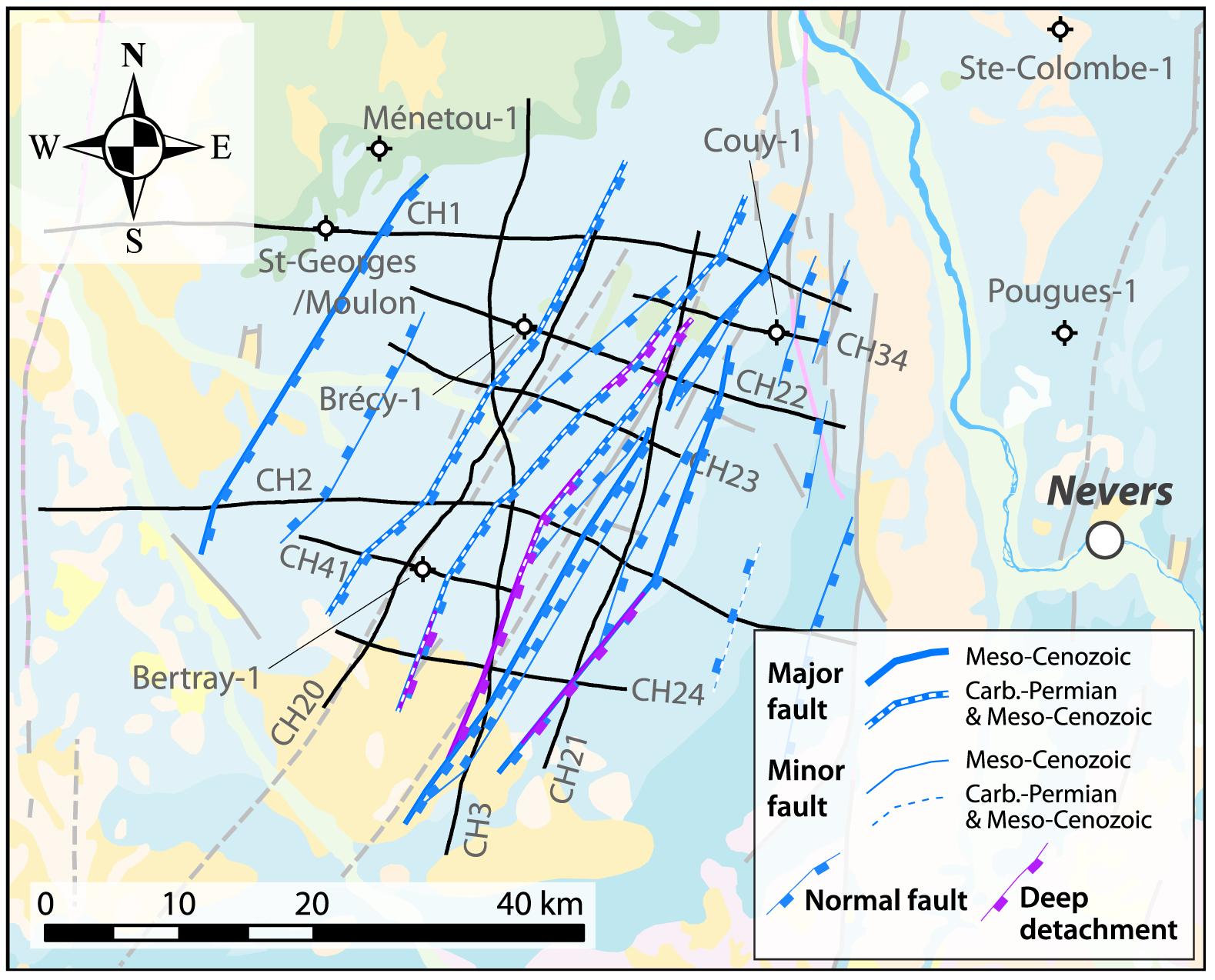
4.3. Thickness maps of the Brécy depocenter
The new seismic dataset is used to accurately estimate the thickness of the Brécy depocenter (Figure 6). Thickness maps in TWT (then in meters) of the Brécy depocenter have been computed based on the interpreted horizons according to the following four steps methodology, by using the Gverse GeoAtlas module of the Gverse suite (© Landmark):
- Computation of grids in TWT for both the TPU and BBU horizons (these grids were calculated by interpolating the corresponding seismic horizons and faults).
- Computation of a thickness map in TWT of the Carboniferous–Permian sedimentary succession by subtracting the two previous grids.
- Calculation of an average interval velocity for the Carboniferous–Permian deposits from the BTY1, SGS1 and COU1 wells, all of which have identified Permian deposits. The velocity for each well is calculated from the thickness of the Permian in meters and in TWT from the seismic data, giving a value of 3778 m/s. We apply this “Permian” velocity to the whole filling, including (i) the intermediate seismic sequence not fully reached by the three reference wells, because the seismic facies are similar suggesting similar lithologies, and (ii) the basal low-frequency/high-amplitude facies, because (a) they represent much lower thicknesses than the Permian deposits and are sometimes even missing, and (b) this velocity is very close to the one estimated in the Arpheuilles well [3615 m/s, Beccaletto et al. 2015; location in Figure 1].
- Computation of a thickness grid in meters by multiplying the thickness grid in TWT by the constant velocity of 3778 m/s.
As the thickness map is based only on the seismic data (there are no close outcropping geological contours to be used as hanging points), the map is hypothetical outside the zones where subsurface data are present. The resulting map displays the Brécy depocenter and its surroundings with an unprecedented resolution. The maximum thickness of the Carboniferous–Permian deposits reaches ca. 3900 m along the CH21 seismic line just south of the CH2 line; it is ca. 900 m thicker than originally expected [Beccaletto et al. 2015] due to a larger velocity value and better interpolation controls (because of the availability of more seismic lines). The minimum thicknesses—about 0 m—are located northeast of the main depocenter.
Thickness map (color range and contour lines) of the Brécy depocenter overlain by the structural map; the geological background is from the 1:1,000,000 geological map of France [BRGM 2003]. Inset: clockwise rotation of the depocenters.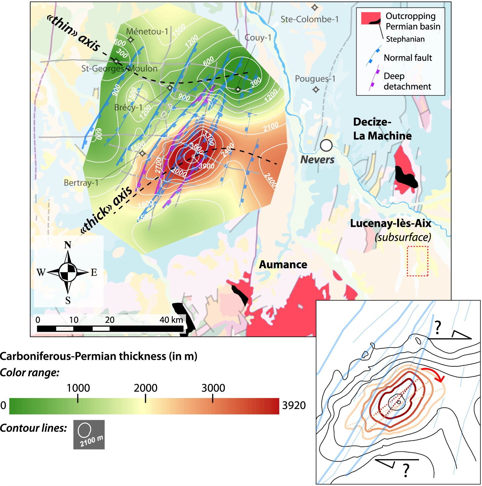
At the main depocenter, the maximum thicknesses of the lower, intermediate and upper seismic sequences are roughly 900 m, 2500 m, and 500 m respectively. The maximum thicknesses of the syn-rift deposits (lower and intermediate seismic sequences, A, B and C units) and post-rift deposits (upper seismic sequence, D unit) are ca. 3400 m and 500, respectively. In more detail, the maximum thicknesses of the A, B, C and D units are approximately 1600 m, 400 m, 500 m and 500 m, respectively.
The main depocenter has an elongated shape trending N60, which is slightly different to the average N30 trend of the scarce Carboniferous–Permian faults; in greater detail, it appears that the successive depocenters represented by the contour lines 3300 m, 3000 m, 2700 m and 2400 m display a clockwise rotation of their longest axis (inset in Figure 6). This could be the result of a dextral strike-slip component during the activity of the normal faults and the opening of the Brécy depocenter, either related or not to the activity of roughly W–E oriented normal faults (not depicted on the seismic lines as mentioned previously). Broadly speaking, the area displays a roughly SW–NE and then a W–E “thick” axis, located south of a roughly W–E oriented “thin” axis. These features suggest the combination of two deformational trends—N30 vs. W–E—the N30 trend is the only one expressed by normal faults. One hypothesis for this could be that the W–E trend is evidence of similar deeper trends that have already been identified in the basement [Baptiste et al. 2016].
4.4. Depositional environment of the four reference wells
4.4.1. Electrofacies description
The lithological evolution can be defined from each studied well using well-log data and the description of the cuttings.
Based on biostratigraphy data [Bertray1 1987], the boundary between the Carboniferous and Permian is located at 2842 m. The lower Permian sedimentary succession is characterized by the Autunian facies [Bertray1 1987], which is composed of, from base to top (Figure 7):
Correlations between the BTY1, BCY1 and SGS1 wells based on stratigraphic cycles.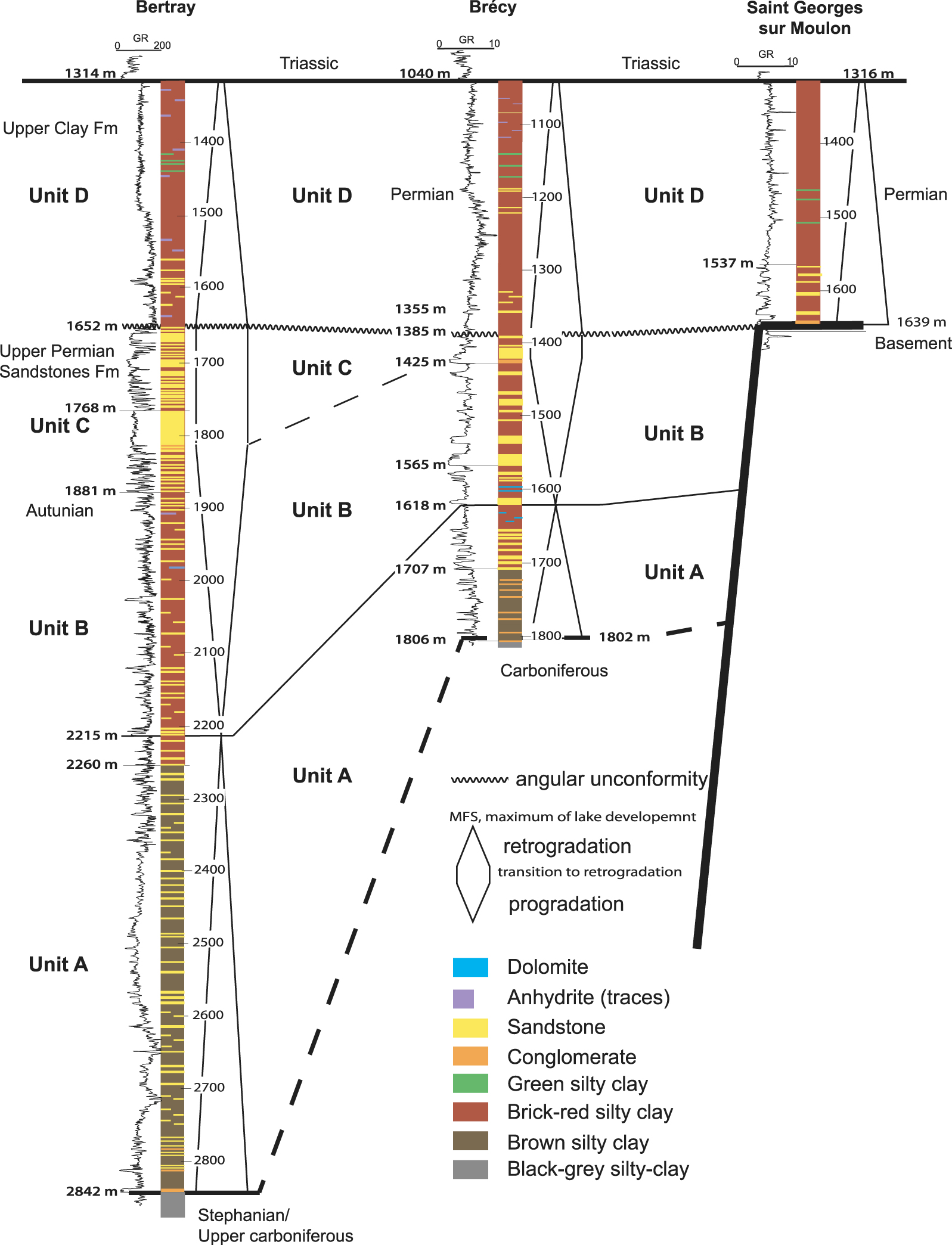
- from 2842 to 2260 m, by conglomerates (only until 2778 m) and coarse-grained sandstones characterized by low to medium GR (15 to 80 API) and Sonic (50 to 70 μs/ft) values, thereby evidencing low-porosity facies, alternating with clayey sandstones with GR from 80 to 120 API and Sonic below 60 μs/ft, and brown silty-clay facies characterized by GR from 120 to 200 API and Sonic from 55 to 110 μs/ft;
- from 2260 to 1881 m, by brick-red micaceous silty-clay with traces of anhydrite and dolomite, (GR from 120 to 140 API and Sonic from 55 to 70 μs/ft), alternating with fine- to very fine-grained clayey micaceous sandstones (GR from 90 to 120 API and Sonic from 50 to 60 μs/ft), and white quartzite sandstones (GR from 45–90 API and Sonic from 40–50 μs/ft).
The upper part of the BTY1 well is composed of two distinct facies from base to top, the name of these formations is found in Bertray1 [1987]:
- the Upper Permian Sandstones Formation, from 1881 m to 1652 m, is characterized by pink fine- to coarse-grained unconsolidated well-rounded sandstones (GR from 45–75 API and Sonic from 55–65 μs/ft), with few beds of conglomerates described from cuttings around 1800 m, and alternating with brick-red clay (GR from 90 to 130 API and Sonic from 75–90 μs/ft) or micaceous silty-clay (GR from 75 to 150 API and Sonic from 60 to 75 μs/ft);
- the Upper Clay Formation, from 1652 to 1314 m, is composed of brick-red micaceous silty-clay with few beds of green clay in its upper part (GR from 90 to 150 API and Sonic from 40–80 μs/ft), and traces of anhydrite; this formation is sandier at the base.
The BRC1 well, drilled in [1966], is older than the BTY1 well [1987] and therefore has only GR in c/s, Neutron (c/s) and resistivity well-logs, and thus can only be used to provide a qualitative comparison of the GR signal with the other wells (Figure 7). In Brécy1 [1966], the Carboniferous is reached below 1802 m, and the sedimentary succession up to 1707 m has been considered as transitional facies from the Carboniferous to Permian based on conglomerates interbedded within brown-red micaceous silty-clay. Based on a previous seismic interpretation (cf. chapter 4.1) and well-log data, these facies are considered as Permian. Above 1707 m, BCY1 is considered as undifferentiated Permian Brécy1 [1966] and has the following composition, from base to top:
- from 1707 m to 1565 m: coarse-grained sandstones to conglomerates interbedded with brown-red micaceous clay with carbonaceous clay around 1676 m, clayey sandstones and dolomitic nodules (highest resistivity and lower GR values between 1580 and 1651 m);
- from 1565 m to 1425 m, the sandstones, with sometime dolomitic cement, are interbedded in micaceous brick-red silty-clay;
- from 1425 m to 1355 m, the sandstones, interbedded with brick-red micaceous silty-clay, are pink, sometimes clayey, with a thin conglomeratic bed at the base of the sandstone level (lowest GR value and highest resistivity);
- from 1355 m to 1040 m, the succession is composed of brick-red micaceous silty-clay, sometimes green and interbedded with a rare and thin bed of fine-grained clayey sandstones (lowest GR value and highest resistivity) or traces of anhydrite and gypsum [Brécy1 1966].
The SGS1, dated 1964, has only GR (c/s) and resistivity, and is considered as an undifferentiated Permian succession [St. Georges-sur-Moulon1 1964] that is characterized from the base to top by (Figure 7):
- from 1639 m to 1537 m, conglomerates and fine- to medium-grained micaceous white to pink sandstones, sometimes dolomitic, interbedded with brick-red-brown micaceous and dolomitic silty-clay;
- from 1537 m to 1316 m, brick-red micaceous silty-clay with sometimes green clay, rare sandstone levels and traces of anhydrite.
4.4.2. Interpretation of depositional environment
An interpretation of the depositional environment evolution can be proposed by performing a comparison with adjacent areas. The wells with thicker and deeper deposits, i.e., BTY1 and BCY1, display different facies at the base of the succession with coarse-grained and conglomerate facies interbedded with brown silty clay facies, with scarce carbonaceous clays. These facies could attest to a sediment supply attributed to an alluvial fan or delta fan within deeper lake deposits as described southward in the Lucenay-lès-Aix area [Ducassou et al. 2019; Mercuzot et al. 2021].
Compared with the core description of COUY1 [Juncal et al. 2018], the mainly red silty-clay facies observed in the upper part of these wells (unit D, Figure 8), with some dolomitic beds, can be considered as a shallow lake. The sandstone and very few conglomerates, attesting to a sediment supply from a continental area, are attributed to an alluvial fan sediment supply within the lake [Juncal et al. 2018], the sediment supply is higher in COUY1 than in the three other wells (Figures 7, 8). This upper part of the sedimentary succession shows traces of anhydrite and gypsum from the description of the cuttings that could reflect an environment with more evaporation. However, given that only traces were observed and that no anhydrite has been observed in the shallow lake deposits of the COUY1 well [Juncal et al. 2018], we cannot exclude that these evaporites originate from the aforementioned Triassic deposits. Furthermore, the presence of paleosol developments may be indicated by dolomitic nodules and green clay facies, which could characterize either dolocretes or hydromorphic paleosols [Retallack 1988; Tabor and Montañez 2004], such as those observed in the COUY1 well [Juncal et al. 2018].
Correlations between the SGS1, BCY1 and COUY1 wells based on stratigraphic cycles.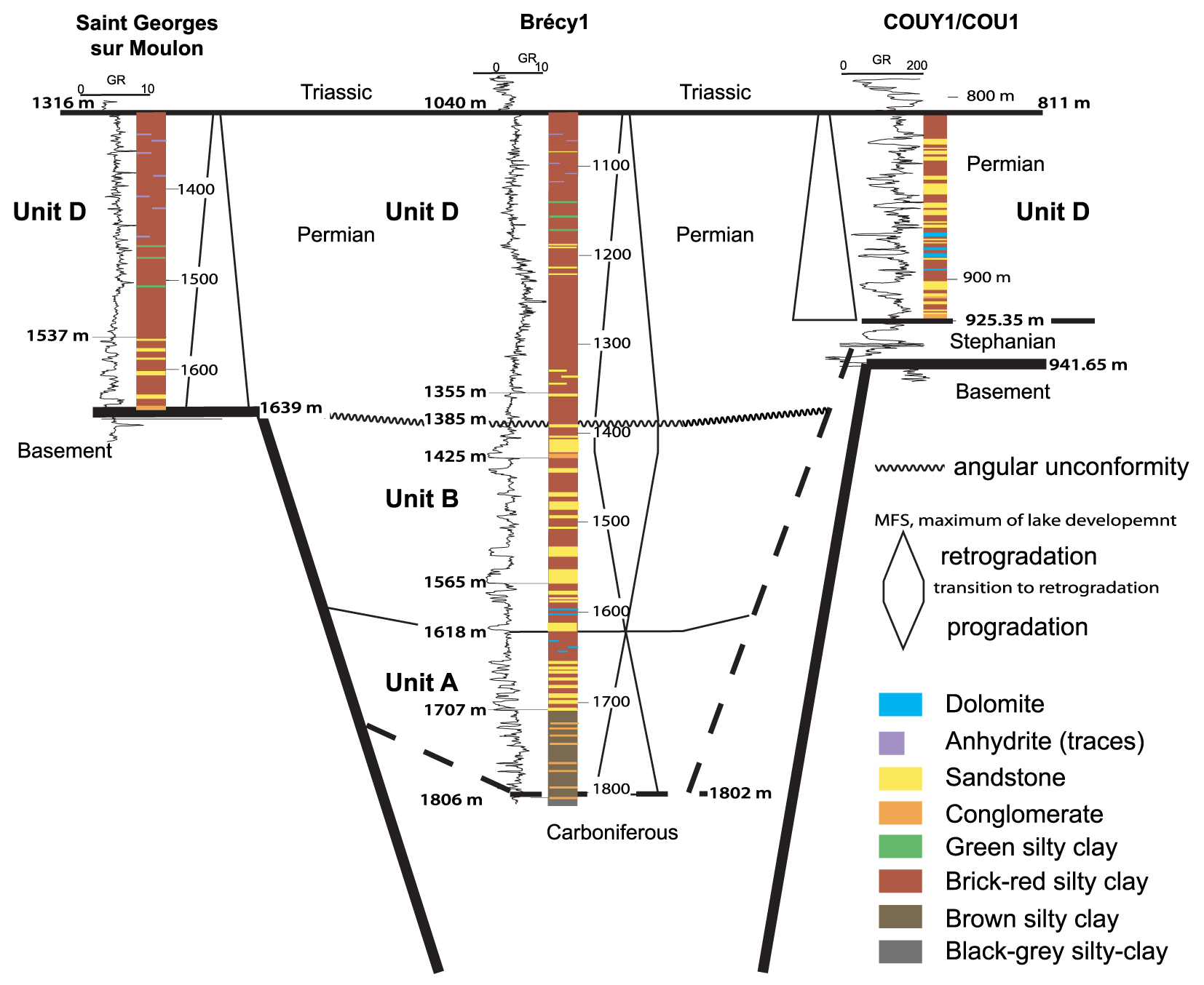
The depositional environment of unit B (Figures 7, 8), compared with the lithology defined in units A and D, could be considered as fluvial or an alluvial fan in a lake environment, but with predominantly coarse-grained sediment from the continental area. The unconsolidated well-rounded pink sandstones described only at BTY1 (unit C) could be attributed to aeolian deposits, but due to the lack of core data, this is difficult to confirm.
4.5. Sequence stratigraphy correlations
The correlations have been cross-checked with the seismic lines to maintain coherency between the well and seismic interpretations. We propose correlations between the four wells based on the electrofacies description and the vertical evolution of the depositional environment (Figures 7, 8). The most complete Permian sedimentary succession is observed in the BTY1 well. From 2842 m to around 2215 m, the vertical evolution from a predominance of conglomerates and sandstones to a predominance of silty-clay corresponds to unit A on the seismic lines (Figures 3, 4) and attests to a general trend towards an open lake (Figure 7). The sandstones and conglomerates can be attributed to alluvial or delta fan deposits in comparison with adjacent areas [e.g., Ducassou et al. 2019; Mercuzot et al. 2021, 2022]. After this maximum of lake development (Figure 7), the clay facies become micaceous, sandier, and display some level dolomites indicating a shallower lake environment that corresponds to unit B on the seismic lines (Figures 3, 4). They vertically evolve to well-developed sandstone facies reached at 1652 m and correspond to unit C (Figure 7). This evolution from the maximum of lake deposits to the top of the sandstones attests to a general coarsening upward trend with more sediment supply around 1768 m (Figure 3). These sandstones are usually characterized by a clayey matrix and some conglomerate beds and could be attributed to fluvial or alluvial fan deposits; their upward evolution until 1652 m to unconsolidated well-rounded sandstones could suggest aeolian deposits interbedded within some red-silty clay facies. The general evolution, which corresponds to the intermediate seismic sequence (Figures 3, 4), allows to characterize a retrogradation and progradational trend from unit A to unit B (Figure 7). Unit C may characterize the transition to a next retrogradational trend. However, it is difficult to define without core data, i.e., the sandstone recorded the transition from a progradational to retrogradation trend, and particularly if aeolian deposits are preserved [Bourquin et al. 2009; Olivier et al. 2023]. Moreover, based on seismic data, a well-defined angular unconformity has been defined at the top of unit C (i.e., in between the intermediate and upper seismic sequences; Figures 3, 4). As a result, unit D is not in continuity with the previous sedimentary succession. Above 1652 m, the sedimentary succession shows shallow lake deposits made of clay with some traces of evaporites, green clay and dolomitic nodules; the latter most probably represents some paleosol developments. This evolution characterizes a retrogradational trend (Figures 7, 8) ended by the Triassic unconformity and corresponds to the upper seismic sequence (Figures 3, 4).
For the BCY1 well, the whole sedimentary succession overlying probable Carboniferous deposits (top at 1802 m) is thinner than in the BTY1 well. A first trend is observed from conglomerates and sandstones until a maximum of lake deposits around 1618 m is reached (unit A; Figures 7, 8), correlated with the basal retrogradational trend of BTY1. A progradational trend, with well-developed sandstones and conglomerates evolving to fine-grained micaceous sandstones is observed until 1425 m (unit B; Figures 7, 8). Unit C is less developed in this borehole. Above the angular unconformity (1385 m), the same retrogradational trend as in BTY1 is observed, but with more sandstone and conglomerate deposits attesting to an area with more sediment supply (unit D; Figures 7, 8).
In the SGS1 and COU1 wells, the Permian sedimentary succession has a reduced thickness corresponding to a general retrogradational trend from conglomerates and sandstones to silty-clay facies. The latter corresponds to the same facies belonging to the upper retrogradational trend of the three other wells (unit D; Figures 7, 8), with the occurrence of more sandy beds in COU1 (Figure 8). In this well, eight retrogradational–progradational cycles were described based on core analyses within this retrogradational trend [Juncal et al. 2018], but in the absence of core data it is impossible to propose correlations at this high-resolution scale with the BTY1, BCY1 and SGS1 wells.
5. Discussion
5.1. Tectonic evolution of the Brécy depocenter—regional comparisons
The new seismic reprocessing greatly improves the understanding of the structural style of the Brécy depocenter, leading us to discuss the modality of its syn- and post-rift tectonic evolution (Figure 9), and to look for similar patterns in other LOCPB.
Present-day situation and tectonic evolution of the Brécy depocenter, using the representative composite CH41-20-2 seismic line. The syn-rift, uplift and post-rifts phases are successively depicted; the ages come from comparison with the Lorraine-Saar-Nahe Basin; see text for explanations.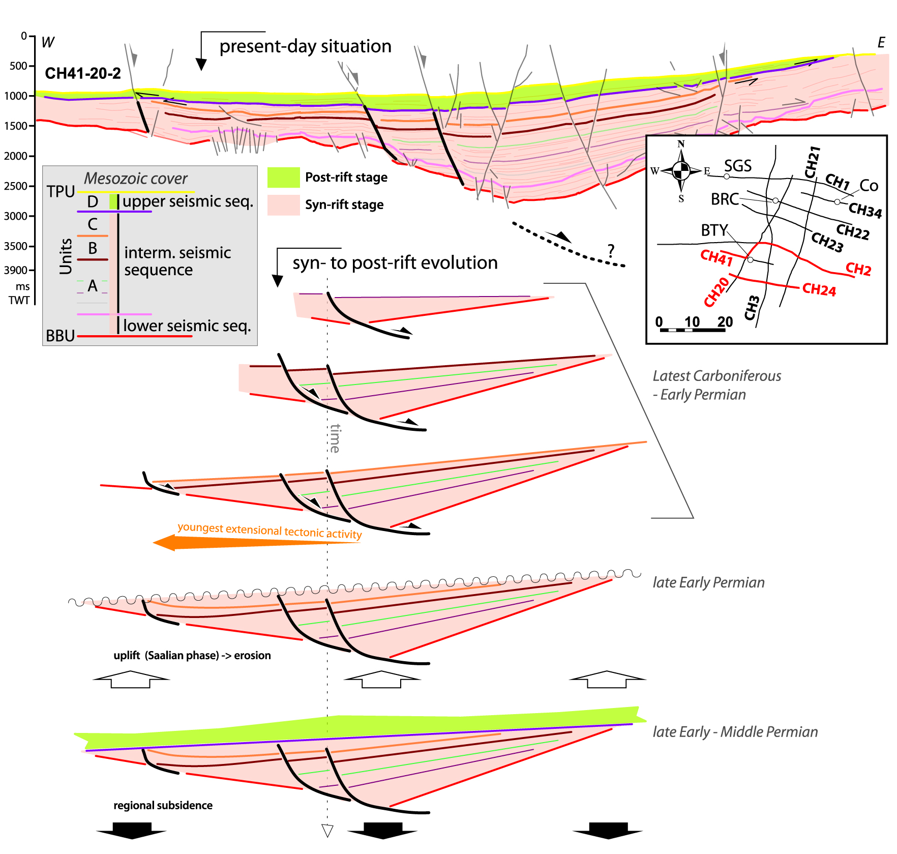
5.1.1. Syn-rift stage
The new interpretation confirms and refines the multi-step widening scenario for the Brécy depocenter, controlled by the westward migration of a few successive active normal faults and their related depocenters, thinning and onlapping each other eastward (Figure 9). Some of the normal faults may be connected to deep detachments located in the pre-Stephanian basement, giving them a listric geometry at the time of the deposition (Figure 9). In fact, upper crustal extensional detachments in the footwall of LOCPB are a common structural feature around the Massif Central [Echtler and Malavieille 1990; Burg et al. 1994; Faure 1995; Gardien et al. 2022], and such detachments have been described close to the study area in the Autun and La Serre regions 150 km east of the Brécy depocenter [Choulet et al. 2012].
This induced the creation of an accommodation space that recorded a retrogradational trend characterized by well extended lacustrine deposits (unit A), followed by a progradational trend (unit B), due to increasing sediment supply in this subsiding context, before a probably new retrogradational trend (unit C) was abruptly ended by the angular unconformity (Figures 7, 8).
The intersecting N20-trending CH3 and CH21 lines are parallel to the main structural trend (Figure 6). There, the eastward facing normal faults are sub-parallel to the lines, so that they appear as flat lens-shape features subparallel to the BBU, disturbing the geometry of its reflectors. Deeply seated highly energetic reflectors in the basement below the BBU also occur and are similarly interpreted as potential extensional detachments planes.
All the above observations point to a syn-tectonic filling of the basin in an overall extensive tectonic regime during the latest Carboniferous–early Permian, characterizing the syn-rift stage of the Brécy depocenter. The maximum thickness of the syn-rift stage is ca. 3400 m.
5.1.2. Post-rift stage
The syn-rift activity is followed by a post-rift stage, whose occurrence is documented by the toplap geometry of the horizons of the syn-rift stage (mainly belonging to units B and C) below the first deposits of the overlying unit D (upper seismic sequence, that corresponds to a new stratigraphic cycle where only its retrogradational phase is recorded due to an unconformity before Triassic sediment preservation) (Figures 5, 6, 9). The toplap geometries, observed in the whole area, provide evidence for the uplift and subsequent erosion of the syn-rift sediments before the deposition of the post-rift stage s.s. The latter is roughly isopach throughout the Brécy depocenter (ca. 0.25 s TWT, corresponding to ca. 500 m), and extends laterally beyond the syn-rift stage. Another typical feature characterizing the post-rift stage is the absence of faults controlling the sedimentation. When considered together, these features suggest that the post-rift stage developed under a regional subsidence regime, which is certainly related to the late orogenic thermal relaxation of the hot Variscan crust [e.g., Averbuch and Piromallo 2012; Vanderhaeghe et al. 2020, and references therein]. Toplaps of horizons belonging to the post-rift stage below the Triassic deposits suggest that the whole Brécy depocenter (i.e., syn-rift and post-rift stage) was then slightly tilted and subsequently eroded before the arrival of the first Triassic sediments. This erosional event may explain the relative low thickness of the post-rift stage (well depicted in the CH21, CH3 and CH41-20-2 seismic lines, Figures 5, 6). Beccaletto et al. [2015] checked and found similar geometrical and structural patterns in the adjacent Contres and Arpheuilles depocenters (thick syn-rift record beneath a thin isopach post-rift record).
The transition from a tectonic subsidence regime accommodated by discrete faults (syn-rift stage) to a regional subsidence regime (post-rift stage) through an uplift phase has not been documented yet in other French LOCPB, except in the Lorraine region (location in Figure 1). There, the latest Carboniferous–lower Permian syn-rift deposits are also controlled by listric normal faults rooting downward in deep decollement levels [Hemelsdaël et al. 2023]. They are then eroded following their uplift and tilting, before the arrival of the early to middle Permian post-rift sediments [Henk 1993; Stollhofen 1998]. The latter are then themselves eroded (toplap geometries below the Triassic deposits) before the deposition of the first Triassic sediments, as in the Brécy area [Hemelsdaël et al. 2023]. Further east in Germany, the Upper Rotliegend units of the Saar-Nahe (eastward prolongation of the Lorraine Basin), Thuringian Forest and Saale basins may also record these post-rift events [Hertle and Littke 2000; Schäfer 2011; Schneider and Romer 2010]. In the literature, the tectonic phase responsible for the uplift is attributed to the end of early Permian Saalian phase [e.g., McCann et al. 2008a; Pharaoh et al. 2010; Stille 1924; Ziegler 1990], originally described in Central Germany, where folding and local tectonic inversion occur [Hertle and Littke 2000; Kneuper 1976]. In addition to the observations made in the Brécy depocenter, the shortening phases recognized in some French LOCPB may also be related to this poorly known Saalian phase [Blès et al. 1989; Bonijoly and Castaing 1983; Gélard et al. 1986; Genna and Debriette 1994; Mattauer and Matte 1998]. Going back to the Brécy area and according to this scenario, the base of the post-rift stage (unit D) would correspond to the superposition of two regional unconformities, i.e., the post-rift unconformity and the post-Saalian unconformity.
Lastly, it is unsurprising to not find explicit evidence of such a post-rift event in the French outcropping LOCPB, as the related deposits have certainly been partly removed by subsequent Meso-Cenozoic erosion [Barbarand et al. 2013; Guillocheau et al. 2000]. They are best fully described in subsurface settings beneath their Mesozoic cover, where the Permian deposits (including post-rift sediments) are still preserved and therefore accessible to seismic observations; in other words, the subsurface prolongation of other LOCPB around the Massif Central (e.g., Brive, Rodez, Saint-Affrique) may indeed preserve such post-rift deposits, even though they have not yet been identified. The recognition of a syn-rift stage followed by a regional uplift and a post-rift stage in the late Carboniferous–Permian Brécy depocenter is of great importance, as it allows to make a geodynamic connection with known LOCBP in eastern France and Germany. It confirms that the development of late Variscan basins is controlled by a large-scale (western Europe) underlying geodynamic event [e.g., the lithospheric delamination and removal of the Variscan mantle roots, e.g., Arnold et al. 2001; Averbuch and Piromallo 2012]. Later, the arrival of the first Triassic sediments attests to the subsequent long-term Mesozoic thermal subsidence of the lithosphere, which led to the formation of the Paris Basin as a post-Variscan sag basin [Averbuch and Piromallo 2012; Prijac et al. 2000; Robin et al. 2000].
5.2. The Brécy depocenter was belonging to a much larger basin—local vs. regional correlations
In addition to structural and tectonic aspects, which are difficult to understand without seismic data, another way to look for lateral correlations of the Brécy depocenter with neighboring basins is to track the thicknesses of preserved end-Carboniferous–Permian deposits, their facies and paleoenvironments, and age similarities. In this section, we aim to connect the Brécy depocenter to the LOCPB of the northern Massif Central, before looking for wider-scale regional correlations.
First, as already demonstrated, the Brécy depocenter is undoubtedly connected westward to the Contres depocenter (which itself is connected to the Arpheuilles depocenter), as shown by the continuity of the Permian reflectors on the seismic lines between the three depositional areas [Beccaletto et al. 2015]. It is difficult to assess the occurrence of end-Carboniferous–Permian deposits north to northeast of the Brécy depocenter as there are no available seismic lines; this is also the case for its southwest prolongation. The few available spatially dispersed wells in these areas indicate that the Triassic deposits rest directly on basement rocks without intervening Carboniferous–Permian deposits (weathered granite in the Pougues-1 and Sainte-Colombres-1 wells, micaschists in the Ménetou-1 wells; location in Figure 2). It is however impossible to definitively conclude on the complete absence of Carboniferous–Permian rocks to the north of the Brécy depocenter based on such scarce data, as they may occur in between the wells. It could for instance be the case along the roughly N–S Loire-Sancerre fault zone and its northward prolongation as suggested by Delmas et al. [2002] (Figure 10). In addition, recent work done by the 45-8 Energy Company and BRGM leads to the recognition of new small subsurface Permian deposits southwest of the La Machine area [Hauville et al. 2021; Jacob et al. 2021]. This very local Permian occurrence may be connected to the Brécy depocenter, but their connection is not yet known.
Estimated extent of the “northern Massif Central Carboniferous–Permian Basin” on a present-day geological map; the geological background is from the 1:1,000,000 geological map of France [BRGM 2003].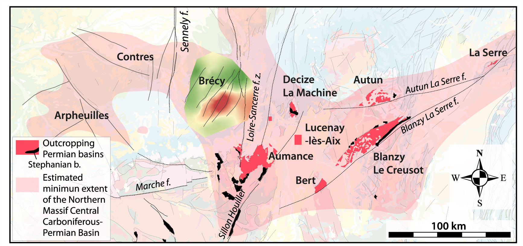
Further south, it is strongly tempting to extend the Brécy depocenter to the outcropping Aumance Basin, although there is no direct evidence for this (no seismic line or well data). Extensive research has been carried out in the Aumance area for the purpose of uranium exploration, resulting in detailed sedimentological and structural descriptions based on numerous borehole and scarce seismic data [Mathis and Brulhet 1990]. There, the Buxières Formation with gray Autunian facies has been dated close to the Carboniferous–Permian transition [298.59 ± 0.35 Ma, CA-ID-TIMS method, [Mercuzot et al. 2023]; Figure 11]. This formation is overlain by red Autunian alluvial to lacustrine facies (Renière Fm.). Both facies are similar to those belonging to the intermediate seismic sequences (units A and B) of the Brécy depocenter. When considered together, these facies provide evidence for a syn-rift stage [Mathis and Brulhet 1990; Paquette 1980]. Note that the Aumance is not located along strike of the N30-trending Brécy depocenter, but instead is shifted to the east, such that the former should not be seen as the southward prolongation of the latter but as a parallel basin (Figure 10).
Eastward, recent works from Mercuzot et al. [2021, 2022] suggest the connection of the Decize-La-Machine (including the Lucenay-lès-Aix depocenter), Aumance, Autun and Blanzy-Le Creusot Stephano-Autunian basins: their lacustrine environments (from alluvial fan/fan delta to deep lake) and depositional ages are similar [latest Carboniferous to early Permian; Ducassou et al. 2019; Pellenard et al. 2017]. Here again, the Permian facies are similar to the intermediate (units A) seismic sequences of the Brécy depocenter, and they display seven retrogradational–progradational cycles within a general retrogradational trend ended by an unconformity overlain by Triassic deposits [Mercuzot et al. 2021]. Even though we observed the same general retrogradational evolution in the Brécy area (unit A), it is not possible to make a detailed comparison between these two areas because no age is available at the top of the Permian in the Decize-La-Machine area. Consequently, the absence of sandstones in units B and C (i.e., mainly a progradational trend) in Decize-La-Machine is either due to the erosion of these units or to a local sediment supply in the Brécy area, which is not recorded in Decize-La-Machine. However, a significant difference lies in the cumulative thickness of the deposits, which are unsurprisingly much lower in the outcropping basins (ca. 1 to 1.2 km) compared to the Brécy depocenter (2.5 km; Figure 11). Such large cumulative thicknesses are only reported from the Blanzy-Le Creusot composite basin, where more than two kilometers of Stephano-Autunian deposits are described from coal exploration boreholes [Figure 11, BRGM 1989; Gand 2003]. Further east, structural connections between the Autun, La Serre, Burgundy and southern Vosges basins have also been proposed [Choulet et al. 2012].
Compilation of thicknesses and ages of the main LOCPB in France and Germany, including the Brécy depocenter as a part of the “northern Massif Central Carboniferous–Permian Basin”.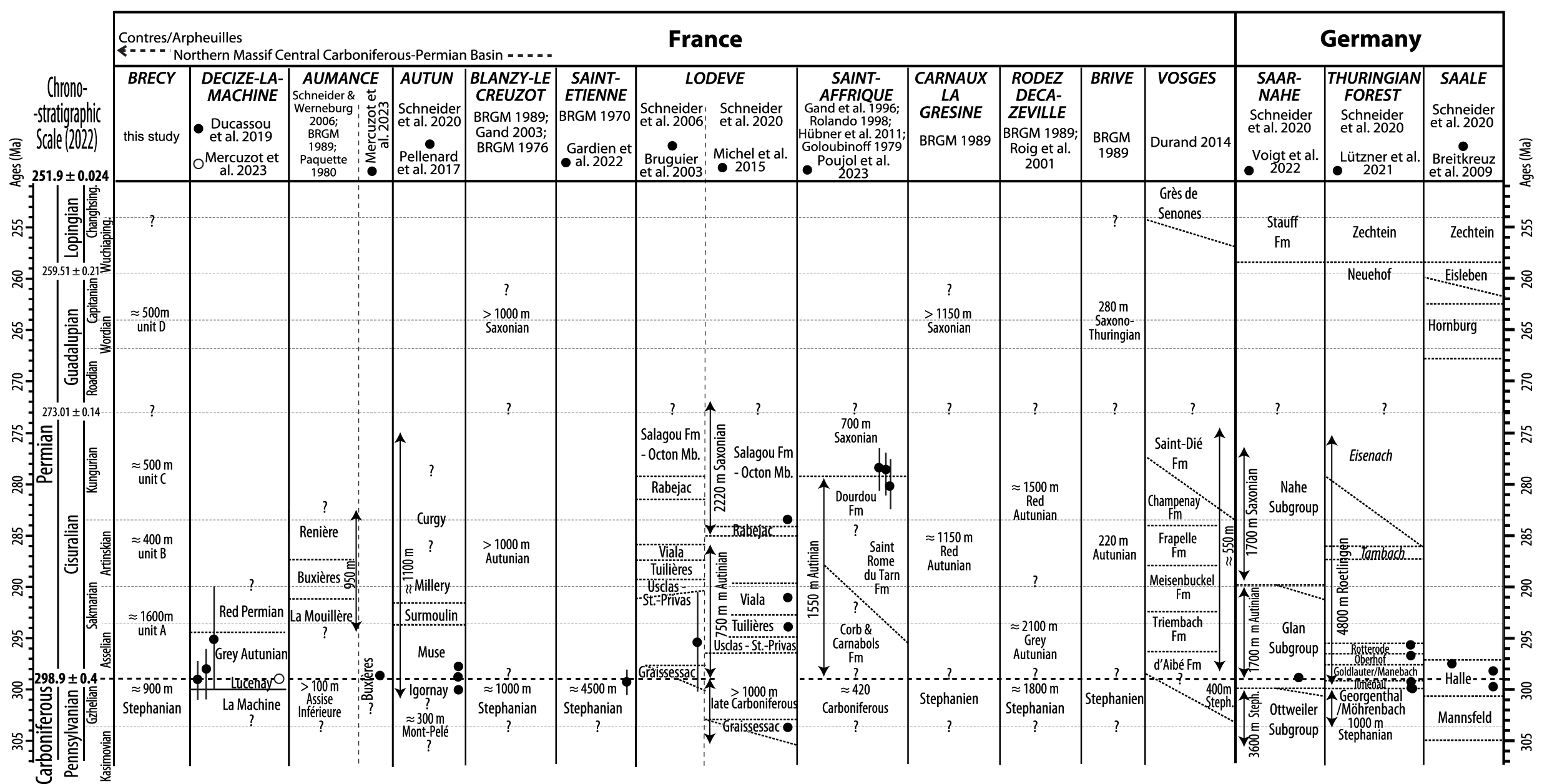
All these observations and interpretations, correlating neighboring basins to each other, imply that these present-day isolated outcropping and subsurface basins, represented by the Stephano-Autunian facies, were part of a larger basin during the latest Carboniferous–early Permian. This larger basin encompassed the subsurface Arpheuilles, Contres and Brécy depocenters and the eastward smaller outcropping basins, spanning more than four hundred kilometers in length, with a roughly W–E trend (“northern Massif Central Carboniferous–Permian Basin”, Figure 10). These regional connections are also confirmed by paleobiogeography data from freshwater shark remains found in the Stephano-Autunian sediments, suggesting connections between all the French LOCPB of the northern Massif Central [including the Aumance, Autun and Blanzy-Le Creusot basins as well as on a much larger scale as far away as Germany; Luccisano et al. 2021; Fischer et al. 2013; Schneider et al. 2020].
It is important to note that the area depicted in Figure 10 (pale blue color) may represent a minimum extent of this wide basin. Indeed, some upper Carboniferous and lower Permian deposits have certainly been removed through time and are therefore lacking, due to (i) the erosion phases known before the arrival of the Triassic sediments [as discussed above and in Beccaletto et al. 2015], and (ii) the Meso-Cenozoic uplift of the Massif Central area and subsequent erosion [Barbarand et al. 2013; Guillocheau et al. 2000].
On a wider scale, unlike the northern Massif Central, several-km-thick Stephano-Autunian deposits are encountered in several LOCPB of the southern Massif Central. These basins, such as Brive, Decazeville-Rodez, Carmaux-La Grésine, Saint-Affrique or Graissessac-Lodève, display similar Stephano-Autunian facies and ages to those observed in the Brécy depocenter and connected smaller basins, and reach thicknesses of up to four kilometers [Figure 11; BRGM 1989; Pochat and Van Den Driessche 2011; Poujol et al. 2023]. Due to the lack of subsurface seismic data, their extensional structural control is rarely imaged [Serrano et al. 2006 for a counterexample in the Aquitaine Basin] and is inferred from indirect observations [Chen et al. 2006; Pochat and Van Den Driessche 2011].
Such thick series are also known in the LOCPB of Germany, for example in the Saar-Nahe and Thuringian Forest basins [Schneider and Romer 2010; Schneider et al. 2020]. There, studies benefit both from favorable outcrop conditions and a large range of subsurface dataset including seismic lines. Consequently, the sedimentary facies and paleoenvironments are well constrained, the lithostratigraphic and extensional structural features are well described, and recent absolute depositional ages are available [Henk 1993; Stollhofen 1998; Schäfer 2011; Lützner et al. 2020; Voigt et al. 2022; Figure 11]. Based on all of these characteristics, they can be considered as other robust reference basins for large-scale LOCPB correlations.
All other LOPCB occurrences in western Europe generally occur in deformed areas as small, isolated patches with low preserved thicknesses, like in the Pyrenees (French and Spanish sides), Cantabria, Sardinia and the Alps and surrounding areas (France, Italy, Switzerland) [Barnolas and Chiron 1996; BRGM 1989; Capuzzo et al. 2003; Cassinis et al. 2012; Knight and Álvarez-Vázquez 2021; Lloret et al. 2018; Pittau et al. 2002; Toutin 1980]. We should also mention the supposedly wider basins with uncertain boundaries, thickness and age attributions that are also known offshore based on seismic data [e.g., Bay of Biscay, Western Approaches; Bois et al. 1991; Ziegler 1990]. These characteristics make all these basins unsuitable for reliable wide-scale comparisons, and cannot be considered as reference basins.
Lastly, arguments in favor of the Brécy depocenter being part of a new wider-scale reference basin (which would be useful for further large-scale correlations, and located in between the two poles represented by the LOCPB of the southern Massif Central and Germany) include: its large preserved thickness (up to 3.9 kilometers), structural record (syn- and then post-rift stages) and age calibration (paleontological and absolute ages from deep wells and comparison with close connected basins with absolute temporal calibrations).
6. Summary and conclusion
The structural pattern, thickness, tectonic evolution and depositional environments of the late Carboniferous–Permian Brécy depocenter are revealed based on the reprocessing and interpretation of 115 km of vintage seismic lines combined with deep well data.
The present-day geometry of the Brécy depocenter is controlled by seven major and eleven minor eastward dipping normal faults; all these faults were active during the Meso-Cenozoic period, and some of them were possibly connected to deep detachments active during the late Carboniferous–Permian history. The maximum thickness of the Brécy depocenter is reevaluated and estimated to be 3900 m.
The filling indicates a thick late Carboniferous–early Permian syn-rift stage overlain by a thin early to middle post-rift stage, similar to the tectonic evolution of the northeastward basins in Lorraine and Germany. The facies generally characterize lake environments, with occurrences of fluvial, alluvial and delta fan deposits. They mainly display a retrogradational–progradational pattern during the syn-rift stage, and a retrogradational pattern during the post-rift stage. The Brécy area is therefore the thickest depocenter known in the northern Massif Central by far. We propose that it was part of a larger basin during the latest Carboniferous–early Permian times, with a roughly W–E trend spanning more than four hundred kilometers in length in the northern Massif Central region. Strictly speaking, all the other so-called outcropping basins (Aumance, Decize-La-Machine, etc.) should be considered as depocenters, as they belong to a wider scale basin.
Because of the above features, this “northern Massif Central Carboniferous–Permian Basin” may be seen as a reference LOCPB, comparable to the basins known in the southern Massif Central, eastern France and Germany. Lastly, our work emphasizes the need for a further multi-method approach to explore LOCBP, especially their subsurface occurrences, as it is crucial to have a full view of these basins that contain information that is inaccessible to their outcropping remnants. It definitely highlights that LOCPB were obviously much wider and thicker than previously expected, with potential effective impacts on the understanding of the late Variscan tectonic and climatic evolution in France and western Europe.
Declaration of interests
The authors do not work for, advise, own shares in, or receive funds from any organization that could benefit from this article, and have declared no affiliations other than their research organizations.
Acknowledgements
This publication was initiated within the framework of the ICDP Deepdust project and was supported by the BRGM’s Research Division. The authors gratefully acknowledge François Baudin, coordinator of this special issue dedicated to Jean Dercourt, for his patience and perseverance. They thank the two anonymous reviewers for their constructive comments, which have greatly improved the manuscript. The authors also thank Sara Mullin for proofreading the English content.