

 CC-BY 4.0
1. Introduction
Created in 1921, the French Central Seismological Bureau (BCSF) has been working for a century to collect and disseminate seismological data relating to France. One of the original BCSF tasks was to conduct macroseismic studies, both on historical (before 1919) and instrumental earthquakes (after 1919), to qualify and quantify the strength of earthquakes regarding the severity of their effects. This task was of particular importance: it was the first step toward a seismic hazard assessment for risk prevention. Once characterized, earthquakes were listed, classified and then arranged on a map, drawing regions of different macroseismic intensity. Afterwards, this map could be used to determine a reference earthquake level for the seismic design of conventional buildings, or the so-called vital constructions or for high-risk industries. The crucial role of macroseismic studies is especially true in the context of twentieth century French seismic hazard assessment for nuclear safety that was conducted in a deterministic way in contrast to a probabilistic one. Before the twenty-first century, hazard assessment used to start with the strongest earthquake found in history and not with the global seismicity of a region. Hence, the deterministic approach gives huge importance to the individual characterization of several strong earthquakes.
At the end of the 1970s, BCSF suffered a crisis that threatened its own existence: responsibility for the macroseismic study of historical and instrumental earthquakes was withdrawn in 1978.1 In this article, I intend to shed new light on this tragic episode by reviewing the transformation of earthquakes from natural events into hazards, which took place in France between 1921 and 1986. During this epoch, the view on French seismicity was progressively reconfigured, from general neglect to edicts to create seismic maps.
I will distinguish three periods. The first extends from 1921 to 1962 and ties in with the birth of French seismicity in France under the impetus of the Rothés, father and son. Both of them successively developed, organized and managed a network of institutions, instruments, data and practices for the characterization of both old and recent earthquakes. In the second period, from 1962 to 1973, the scientific activity of macroseismic studies and the safety needs of the nuclear industry were intertwined. During this period, Jean-Pierre Rothé established himself as a key player in the assessment of seismic hazards in France and acquired a hegemonic expert status on this issue. The third and last period spanned from 1973 to 1986 and was the period when Rothé’s expertise failed. The development of large-scale nuclear industry combined with the increase in seismic expertise within nuclear organizations led to the opening of a Pandora’s box. This opening led to the disclosure of many limits in the way French seismicity was managed. In the wake of this exposure and in order to overcome the flaws, a major research and development program was launched to meet the best scientific requirements and the new needs of the nuclear industry. This program led to a difficult divorce between the nuclear industry and Rothé, as well as all macroseismic studies being transferred from the BCSF. The material used in this article is entirely extracted from my doctoral thesis [Roger 2020].
2. 1921–1962: Increase in French seismicity knowledge thanks to the Rothé family
2.1. The careers of Edmond and Jean-Pierre Rothé
The Rothés, both father and son, were among the most influential scientists in seismology not just in France, but also worldwide during the first two-thirds of the twentieth century.
Edmond Ernest Antoine Rothé (1873–1942) (Figure 1) was a lecturer in physics at the University of Nancy and belonged to a family of Alsatian descent who chose France in 1870 [Schlich and Hoang Trong 2011]. At the time of the First World War, he played an important role in the Central Bureau of Meteorology, which studied the full range of Earth Sciences for military purposes. He was in charge of simulating atmospheric flight conditions and rationalizing aeronautical techniques based on scientific knowledge of the atmosphere. At the end of the war, he took a position as professor at the University of Strasbourg and directed the meteorological service of Alsace-Lorraine as well as the seismological station, both legacies of Strasbourg’s German period [Craig 1984]. The Alsatian capital then possessed the largest seismological observatory in the world,2 and managed from 1903 the centralization and publication of international seismological surveys. The seismological station was transformed in 1921 to the Earth Physics Institute (IPG) and the French Central Seismological Bureau (BCSF), two institutes of which Edmond Rothé was the director until his death in 1942.3 He also created the first geophysical engineering master degree in France. He was Officer of the Legion of Honor and Dean of the Faculty of Sciences of Strasbourg from 1929 to 1935.4 Throughout his management mandates, he constantly developed seismic risk prevention in France and internationally.
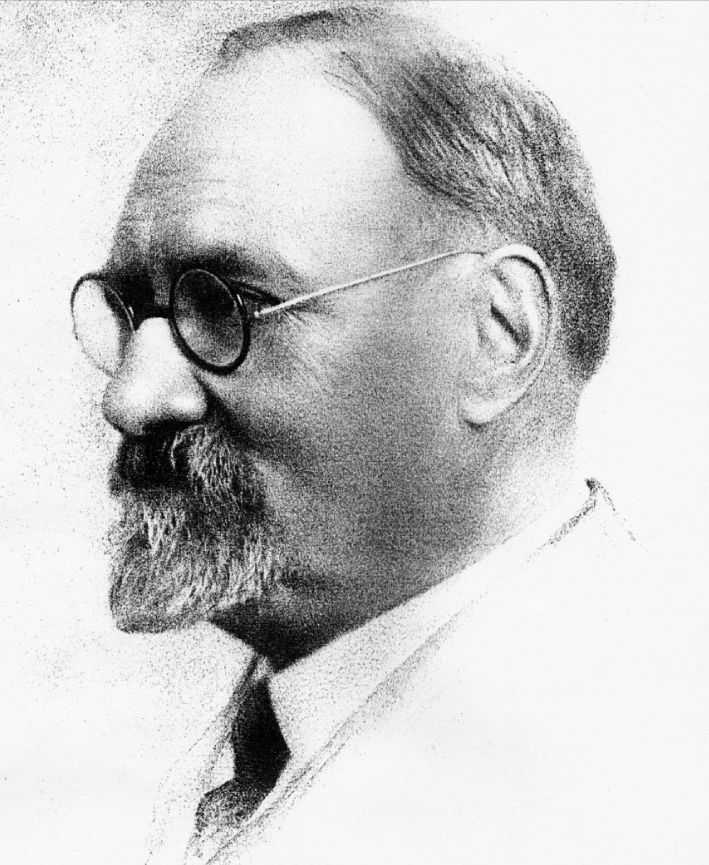
Charcoal portrait of Edmond Rothé (1873–1942), (source: EOST).
Following the death of his father in 1942, the geophysicist Jean-Pierre Rothé (1906–1991) became director of the Earth Physics Institute in Strasbourg until 1968 and of the BCSF until his retirement in 1975 (Figure 2). On a scientific level, he contributed to the discovery and recognition of plate tectonics theory thanks to the seismological data that he gathered, studied and above all shared with the international scientific community [Bates et al. 1982]. That led him to be mentioned alongside his father in the acknowledgments of one of the founding books of modern seismology wrote by Gutenberg and Richter [1949]. He was even commissioned by UNESCO to write the sequel of this classical book in 1965 to describe global seismicity [Rothé 1969]. In addition, Rothé was in constant contact with other spheres of society. In particular, he contributed to the technical, theoretical, and even practical development of mining prospecting by seismic refraction, especially for uranium research on French territory [Roger 2018]. He also participated, with Yves Rocard, in the development of a full atomic bomb tests survey with a seismometric network. This kept him abreast of French atomic tests, in particular for the purpose of calibrating measuring devices. But, above all, he was involved in seismic risk prevention [Roger 2020]. In addition to his work in France, Jean-Pierre Rothé was also mobilized to produce seismic hazard maps in Morocco and Algeria and as official UNESCO expert he worked for risk reduction in emerging countries. Finally, he played a first-rate institutional role as Director of the IPG and the BSCF, and also as Chairman of an international working group. This group brought together some of the most renowned experts in the field of seismic phenomena, which worked both with UNESCO and the European Commission throughout the 1960s and 1970s to build seismic and seismotectonic maps. What differentiates a seismic map from a seismotectonic map is that the latter also includes geological data in seismic mapping.

Photo of Jean-Pierre Rothé (at the left) on board the “Pourquoi pas?” during his expedition to Greenland from 1932–1933 in the context of the International Polar Year (source: Michel Cara).
2.2. The Rothés’ contribution to the study of seismicity and earthquake prevention in France
Both Edmond and Jean-Pierre Rothé contributed to the study of seismicity and earthquake prevention in France. Edmond undertook to establish a full history of earthquakes in France based on the compilation of various catalogs (Von Hoff, Ferdinand Montessus de Ballore and especially Alexis Perrey5 ) as well as archives of learned societies and scattered publications [Rothé 1925]. His catalog lists several hundred earthquakes, indicating their location and their date. Furthermore, he attached all the data describing the damage observed. Depending on the earthquakes considered, the number of entries varies from one to several dozen. In 1919, he also set up the annual publication of the Earth Physics Institute Yearbook (replaced by the “Annales de l’Institut de physique du globe” in 1936), which contained a section reserved for seismology with all the detailed information on the seismic tremors felt each year in France. At the same time, he built up a system for collecting information after each earthquake, by sending questionnaires to the municipalities affected. With this system, BSCF obtained systematic data in sufficient quantity to assess earthquake intensity and for each intensity, to draw the damage extent area after the earthquake (isoseismal line). Edmond Rothé’s actions provided France with a full network for collecting data on its seismicity: an orderly catalog of available archives on historical earthquakes, systematic surveys of effects after an earthquake and an instrumental recording network. At the European scale, he developed a mechanism to share seismological data across countries. However, despite his activism in this field,6 his work was not used for seismic risk prevention.
From a macroseismic study point of view and more precisely, for the conversion of earthquakes into hazards, Jean-Pierre Rothé could be considered pioneering and may be the most decisive figure in France. Firstly, he mapped the 1925–1936 earthquake records and drew their macroseismic radius via the data collected by the monitoring networks set up by his father. Later in the 1940s, he published another studies on south-eastern France seismicity [Rothé 1941]. Albeit the main purpose of those studies was to identify the occurrence of earthquakes along two seismic arcs (cf. Figure 3), a seismicity quantification was specified by a maximum magnitude of 6.2 on the Richter scale and a macroseismic intensity between VIII and X. The scale used by Rothé was the International Macroseismic Scale (IMS). For the sake of clarity, the intensities are translated on the EMS-98 scale, which shows half a degree of difference between intensities V and VIII.
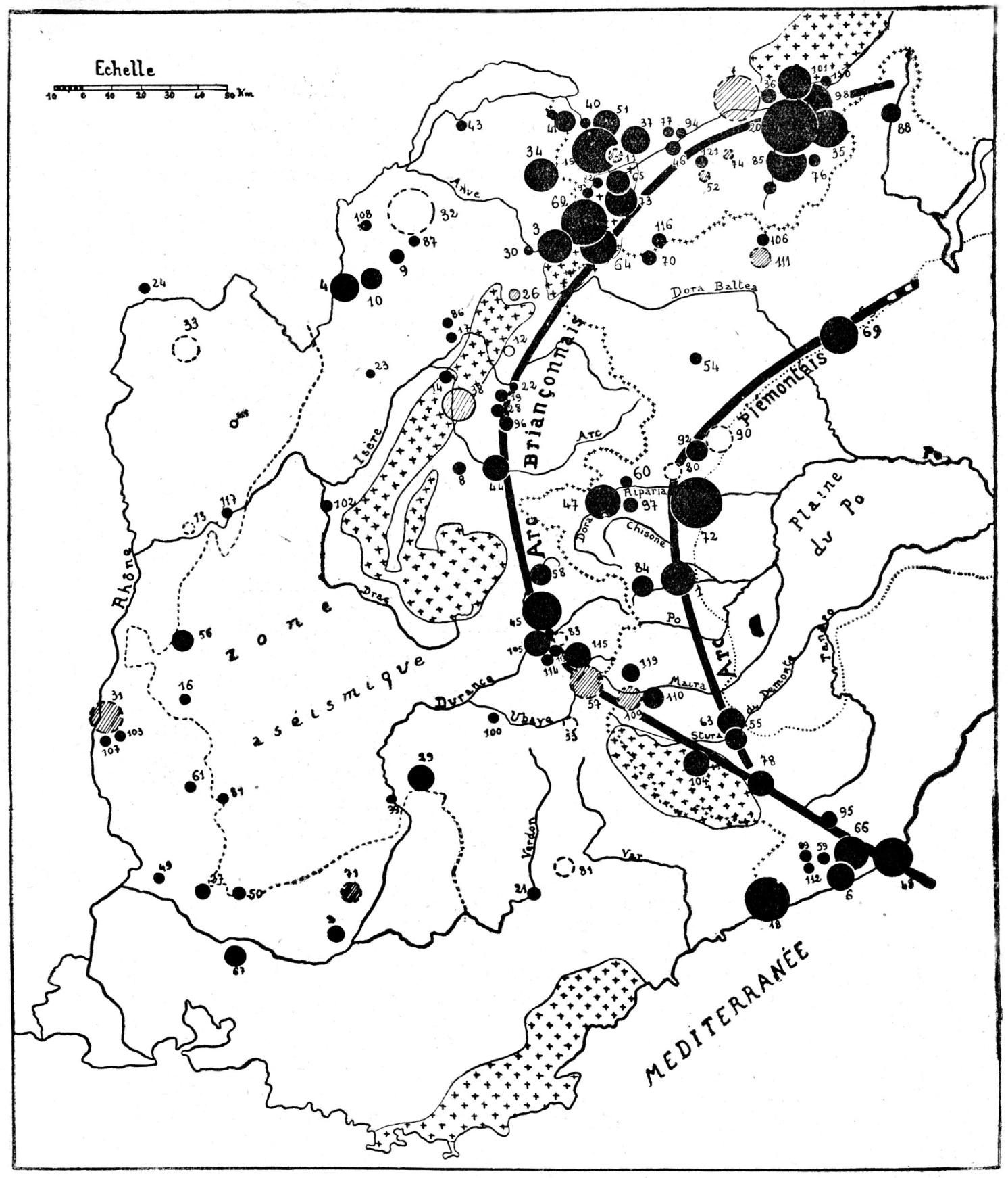
Distribution of earthquake epicenters in the Western Alps (source: [Rothé 1941]).
With the Second World War and the death of his father, Edmond, in 1942, the publication of annual seismic data was interrupted between 1939 and 1948. In 1954, Jean-Pierre Rothé and Nicolas Dechevoy published a study to fill this interruption, gathering all the seismic documentation of the period 1940–1950 [Rothé and Dechevoy 1954]. In this study, for the very first time, they accompanied the seismic catalog with a cartography representing the distribution of epicenters on the metropolitan map of France (cf. Figure 4). However, even if earthquakes were listed according to their macroseismic range, their intensity was not specified. Part of the study to determine the intensity of an earthquake consists in drawing circles, called isoseismal lines, around the epicenter, in which equivalent intensities have been observed. The wider the circle is, the deeper the hypocenter of the earthquake for an equal magnitude. Thus, the two maps drawn in these two studies were not intended for use in earthquake-resistant buildings, but they nevertheless formed the basis of a future seismic hazard map.
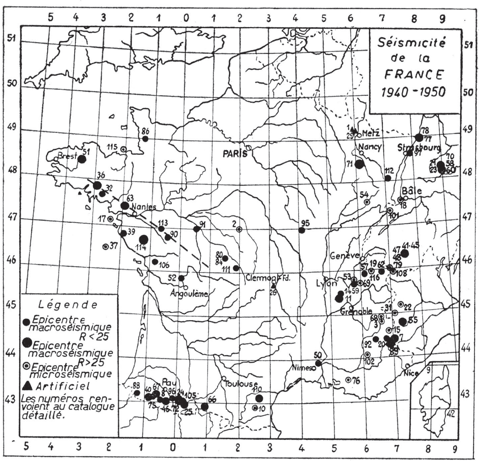
Distribution of epicenters of French earthquakes 1940–1950 (source: [Rothé and Dechevoy 1954]).
2.3. The rise of seismic risk prevention needs in France
On the night of September 8–9, 1954, an earthquake of magnitude 6.8 on the Richter scale occurred in Orléansville, Algeria (the city is now called Chlef). The first seismic hazard map was drawn up after this earthquake in Algeria, a French province at that time, and which caused the death of 1243 people, destroying more than 20,000 homes and leading to the exodus of 300,000 people. The French public saw this event as a tragedy and the government decided that Orléansville had to be rebuilt in a way that it could withstand another earthquake of this kind. Consequently, studies were undertaken to develop the first French seismic building code, the “AS55 recommendations”. Jean-Pierre Rothé joined the seismic hazard map of Algeria to the code and thereby divided the region into three different seismicity zones (none, zone A and zone B). The seismic hazard was expressed directly by seismic coefficients used by engineers without any seismicity quantification in intensity or magnitude. This building code had only a regulatory value in Algeria at a time when seismic risk was largely underestimated or even neglected for the metropolitan area.
On February 29, 1960, an earthquake of moderate magnitude (5.7 on the Richter scale) struck the city of Agadir in Morocco. This earthquake destroyed three quarters of the city and killed more than a third of its inhabitants (between 12,000 and 15,000 deaths for every 35,000 inhabitants). The disaster made the headlines in French newspapers for several days. The point was as much to describe the extent of damage as to narrate the heroism of the 1200 French soldiers conducting relief operations, who belonged to a military naval air base located a few kilometers from the city.7 Moreover, the damage extent compared to the relatively low magnitude of the earthquake was astonishing and made the French public and politicians fear a similar scenario in the metropolis. Theories have been developed to explain this disaster, including the location of the epicenter directly beneath the city (the city was rebuilt 20 kilometers further south in order to move away from the seismic fault) and the poor quality of buildings [Rothé 1962]. However, even in the modern districts of the city, there was a large amount of damage and the multiplication of destructive earthquakes in 19608 kept the public in a state of anxiety.9 Consequently, on May 15, 1960, the French Government set up a commission to review the “AS55 Recommendations” to verify their effectiveness in the face of the Agadir earthquake with the aim of developing a regulation adapted to metropolitan France. This commission was coordinated by Jean Despeyroux, engineer of Ponts et chaussés and director of the North African zone for the company SOCOTEC, author of the “AS55 Recommendations”, but this time it included geophysicists (Labrouste, Rothé and Gourinard), the order of architects, the scientific and technical center of the building, the Bureau Veritas, the Omnium technique de l’habitation, as well as representatives of the Public Works Department and the Commissariat à la reconstruction.
Nine years later, this commission led to the publication of the 1969 seismic building code.
3. 1962–1973: French seismicity and the nuclear industry
3.1. Jean-Pierre Rothé: a bridge between earthquakes studies and the nuclear industry
The year 1962 marked a turning point in the seismic risk perception of nuclear industry engineers in France. Between April 12 and July 15, 1962, a series of 28 earthquakes hit Grenoble and its surroundings, even though it was located in a region previously considered non-seismic. The strongest earthquake was on April 25, known as the Corrençon earthquake, with an estimated magnitude of 5.5 on the Richter scale. This earthquake caused significant damage in Grenoble (“a hundred chimneys were overturned”), estimated at the time at an intensity equivalent to VIII on the EMS-98 scale. In the SisFrance database, the earthquake of April 25, 1962, located in Corrençon, is characterized by an intensity VII–VIII. This earthquake is estimated at a moment magnitude of 5 and a depth of 5 km [Lambert et al. 1996]. Near to Grenoble, a Nuclear Research Center was built in 1956. Building engineers did not take into account the seismic risk in their design following Rothé’s studies of the seismicity of the Western Alps that showed Grenoble city, as well as the Vercors area, as a non-seismic region [Rothé 1941].10 They considered that Rothé’s study was “authoritative on the question”11 and took up the conclusions of the study, word for word, in their seismic hazard assessment.
Following these earthquakes, a new study was carried out by Élie Peterschmitt under the supervision of Rothé.12 His study showed that a large part of the city of Grenoble was located on “recent alluvium, poorly consolidated and low density”, which explained the extent of the damage observed. These unexpected earthquakes also led to questions about the location in the Vercors of past earthquakes, known for the damage they caused, but for which data were lacking to locate their epicenter, including the earthquakes of August 15, 1782, October 15, 1877, and June 24, 1878. Today, we know that none of these earthquakes could be linked to the Vercors region. The first two were absent from the SisFrance database while the last one was located in the Saône valley, 120 km further north.
The Grenoble nuclear site was only slightly affected by the earthquake of April 25, 1962: “buildings did not suffer from shaking and, since that time, no agitation has been detected”.13 According to the engineers responsible for the site’s safety, this was largely due to the fact that the site was located on very hard ground, unlike the city of Grenoble. Although they considered that the safety was not in question, the 1962 earthquakes left a lasting uncertainty in the minds of nuclear safety experts due to the fact that an earthquake occurred in a deemed non-seismic zone. From this date, each new nuclear project was subject to a specific prior study of the seismicity of the region. From this point on, the need for seismic risk expertise was growing in the nuclear industry and Rothé became an indispensable resource.
3.2. Zonation maps for the seismic building code in metropolitan France and its application to NPPs
In 1963, within the framework of the seismic building code revision commission, Jean-Pierre Rothé drew up the first Metropolitan seismic hazard map.14 This map divided the territory into three regions of different seismic intensities (none, low and medium) built from 50 years of instrumental records (1910–1960) (cf. Figure 5). In practice, the map takes into account the Lambesc earthquake of 1909. It is following this event that the network of seismographs was densified and that all the recordings were transferred to Strasbourg for systematic processing and compilation. The building code was used as much as amended throughout nuclear power plant construction between 1963 and 1967; this led to two intermediary versions (PS62 and PS64). The Franco-German Nuclear Power Plant project on the border site of Fessenheim was of particular importance. This project, which began in 1963 and was finally abandoned in 1969, has a central place in the history of the French civil nuclear program, since it was the first economically viable model of a national power plant. Through this project, the nuclear industry intended to move from the experimental phase to the industrial one: the idea was no longer to develop innovative technologies or to increase the power of each new reactor, but to develop a standard model of reactor that was replicable, with the objective of achieving the economic profitability of nuclear energy production [Dänzer-Kantof and Torres 2013]. This transition to the industrial age was accompanied by a strong logic of safety rationalization and design optimization. According to Rothé’s 1963 map, Fessenheim was located on the border between two area of different macroseismic intensity (VI in the north and VII in the south toward Basel). The economic impact of one or the other intensity was considerable. The additional cost of the higher intensity would account for almost 10% of the total cost [Roger 2020].
1963 seismic building code hazard map PS62–PS64.
Facing this challenge, the project’s prime contractor first called on Rothé’s expertise and then funded his work to build a new and more robust hazard map, based on greater historical depth. Throughout the years 1964 to 1967, Rothé was mobilized directly to supervise the seismic hazard assessment for Fessenheim. His expertise went beyond the simple definition of macroseismic intensity and also helped to translate intensity into indicators that could be used by engineers. Specifically, he chose the corresponding relation between macroseismic intensity and the maximum ground acceleration; he determined the quality of the site ground and its incidence on the seismic motion; he provided expertise on the representation of the seismic motion as a function of oscillation frequency (seismic motion spectra and response spectra) as well as on the sufficiency of margins taken in the design to handle uncertainties. Concerning hazard assessment, Rothé estimated that the maximum earthquake for Fessenheim had an intensity of VII and not VI, with a probability of one time in the next 50 or 100 years.15 Following this expertise, the project manager drew the consequences of this evaluation and modified the power plant design. Moreover, he mandated Rothé to work on a much more ambitious hazard assessment. Indeed, the maximum earthquake probability presented by Rothé seemed to him far too recurrent to be used as a reference for the safety of a nuclear site.
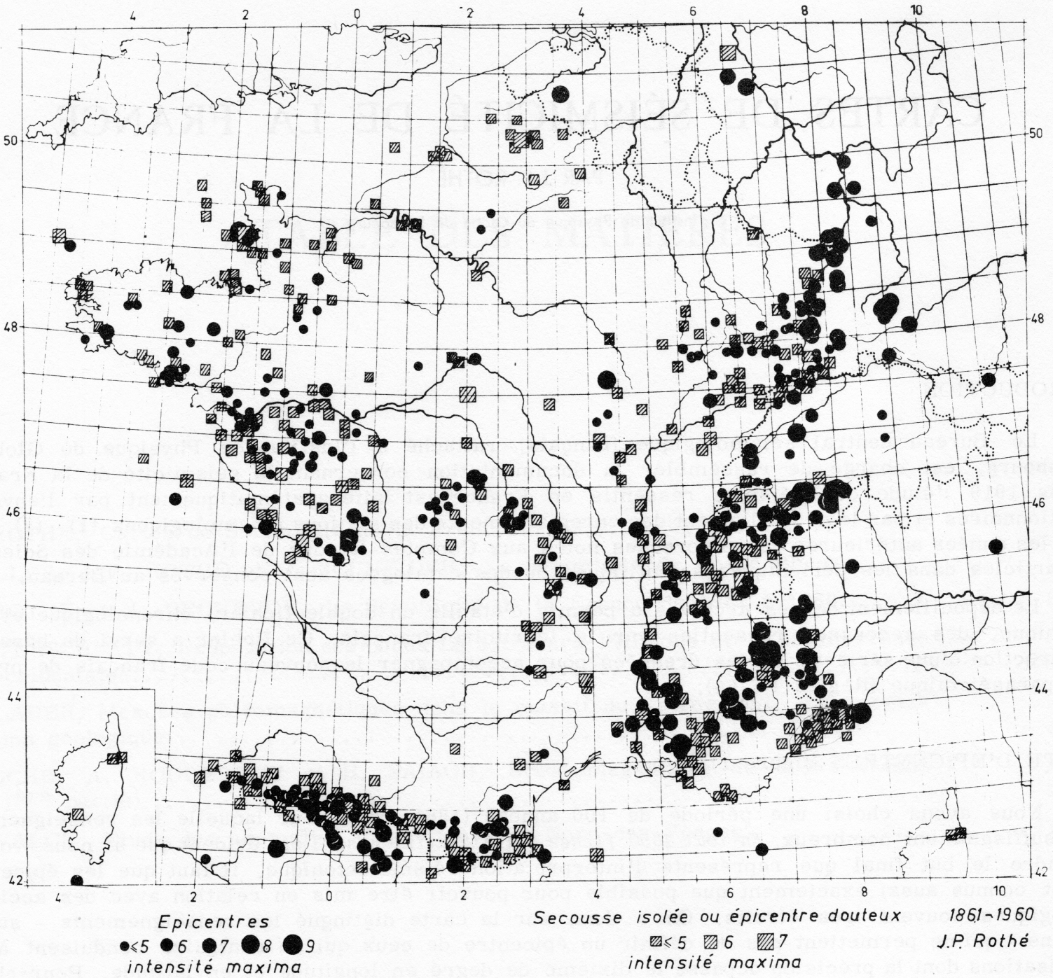
Distribution of epicenters of French earthquakes 1861–1960 (source: [Rothé 1967]).
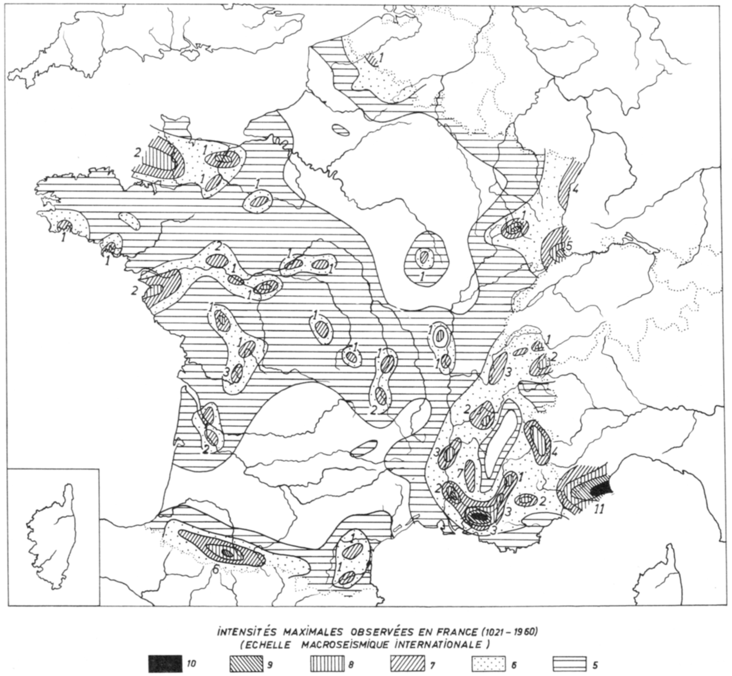
Historically known maximum intensities 1021–1960 (source: [Rothé 1967]).
Between 1964 and 1967, Jean-Pierre Rothé drew up two new additional seismicity maps, one showing the earthquake epicenters in metropolitan France from 1860 to 1960 (including instrumental recordings since 1910), the other showing maximum intensity according to the strongest known events felt over the last 1000 years, between 1021 and 1960 (cf. Figures 6 and 7). These two maps were constructed with the historical earthquake catalog of his father and by attempting to systematically assign a value of intensity to earthquakes that had already been cataloged and located. In addition, only sufficiently well-documented earthquakes were used. In the end, there were 142 earthquakes described on 2500 cards, half of which were only for the period before 1810.16 From the cross-checking of these two maps, Rothé constructed a new version of the seismic hazard map for metropolitan France that he published in 1967 (cf. Figure 8) [Rothé 1967]. This new map divided France into four regions of different seismicity according to the maximum probable intensity expected: a zero-seismicity zone, a VI–VII intensity zone, a VII–VIII intensity zone and a IX–X intensity zone. This map was included in the official publication of the 1969 seismic building code. For economic reasons, its use was reserved for special buildings while conventional buildings were based on the previous version of the map (cf. Figure 5). In the nuclear industry, this new map was used as a reference for the construction of brand-new nuclear facilities.
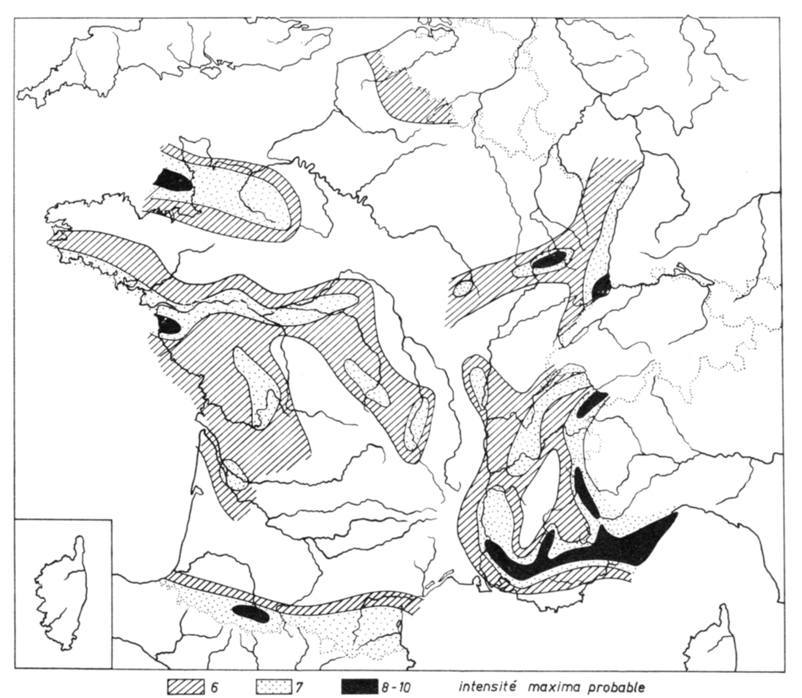
1967 seismic building code hazard map PS69.
3.3. Rothé’s expertise in the nuclear industry and his role in decision-making
At the turn of the 1970s, notably because of the first oil crisis, France gradually moved toward an all-nuclear policy for electricity production. To follow this new craze, the industrial program turned to mass production of uniform nuclear power plants. The logic was no longer to study in detail and adapt each unit design to their environment and political needs but to develop a standardized design that could be replicated in many sites according to a mass production logic like that of the automobile industry or of the construction of American warships during the Second World War [Bréchet and Fluchere 2020]. In this perspective, nuclear safety regarding seismic risks no longer depended on the adequacy of the design in relation to the seismic hazard, but on the difference between the resistance capacities of the generic model and the specific hazard of any given site. In this context, Rothé’s 1967 seismic hazard map was systematically used to determine the hazard of a site and conditioned its viability. When a site was located close to a boundary between two seismic zones or when the geological specificities of a site call into question the adequacy of a site for the standardized model of reactors, Rothé was directly mandated to provide specific expertise. Afterward, Rothé’s opinion was never questioned nor discussed. On the contrary, his opinion was directly included in the power plant’s safety report. However, from 1973, this mechanism, which gave Rothé full power in seismic hazard assessment and ultimately in the acceptance or rejection of a nuclear site, was criticized by the nuclear industry.
4. 1973–1986: When the nuclear industry reshaped French seismicity
4.1. End of Rothé’s era
The year 1973 marked another turning point in the history of seismic risk assessment in France. It was the beginning of the end of Rothé’s hegemonic position. With the first oil shock and as the civil nuclear program accelerated, the nuclear industry, and more precisely, Electricité de France (EDF), proceeded to select numerous sites that could accommodate a standardized model of nuclear power plant. Among these, one site, the Tricastin site located in the Drôme region, caught everyone’s attention in relation to the seismic issue for nuclear safety. This site was chosen to supply electricity to the nearby uranium enrichment plant under construction. It was chosen despite the seismicity of the region that outmatched the seismic reference used in the standardized model of power plant. EDF mandated Rothé to prove that the seismic hazard was in fact overestimated in his 1967 map and that the plant could be built there without any design adaptation.
Rothé’s report, delivered to EDF at the end of June 1973, was based on a very localized approach to seismic hazard assessment that involved a new type of seismotectonic data. First of all, Rothé estimated that the maximum intensity felt historically at the Tricastin site was equal to VII, compared to VIII in his hazard map. Indeed, according to him, the site was located 5–15 km from a seismogenic fault system, but no earthquake had occurred historically at the site itself. Thus, the Tricastin site was far enough for the intensity felt at the site to be attenuated by one degree. Rothé also explained that the seismic building code used a value of VIII intensity for the region to account for the average distance between buildings and faults avoiding the need for any seismotectonic study. Furthermore, Rothé stated that the seismicity of the Tricastin region was well known, due to the recurrence of seismic events and, consequently, the assessment was very accurate.17
On the basis of this report, EDF sent a request for authorization to create a standard model of power plant at Tricastin. The head of the administrative safety body was reluctant to accept the industrialist’s request to deviate from the assessment recommended by the regulations, and in turn, had the Rothé study appraised. Since the latter was based largely on geological and tectonic arguments, the administrative safety body asked the Bureau de Recherches Géologiques et Minières (BRGM), the French national geological service, and its deputy director in charge of the general inspection of the Geological Map, Jean Goguel, for his opinion on the location of faults and the possible migration of seismic events over time. In response, Goguel stated that the method used by EDF was the same as for dams and that it was applied correctly. However, he pointed out that the data used was old and could probably be improved, although he did not feel that this would clarify the definition of earthquakes to be considered. On the one hand, he said, if it was only a conscientious question of respecting a viable method, then there was no need to be afraid since Rothé was the undisputed specialist in France. On the other hand, he believed that many complementary investigations were still possible and that a more thorough assessment of seismic hazard based on all the knowledge of Earth Sciences was not only possible, but also desirable.18
Moreover, the administrative safety body head requested a counter-expertise from the CEA’s group of nuclear safety experts that would become the Protection and Nuclear Safety Institute in 1976 and then evolve into the Radioprotection and Nuclear Safety Institute (IRSN) in 2002. At the beginning of the 1970s, to follow the acceleration of the civil nuclear program, a team of engineers, geologists and seismologists was formed within the predecessor of the IRSN, which in 1976 became the Seismic Risk Assessment for Nuclear Safety Bureau (BERSSIN). For them, Rothé’s expertise, and EDF’s positioning, did not take sufficient account of the uncertainties surrounding French seismicity and did not provide sufficient margin to guarantee the nuclear safety of power plants. They argued that Rothé’s 1967 hazard map used by EDF established events that had a relatively high probability of occurring at the location under consideration. Thus, in order to obtain a sufficient level of safety, it would be necessary to take into account the maximum intensity of the whole region and not only the site itself and to add an additional safety margin to the scenario in order to compensate the relatively high probability of occurrence. They also stated that in the past, on several occasions, the seismic levels specified by Rothé had been exceeded by real earthquakes, notably in the Vercors with the Corrençon earthquake in 1962 (intensity VIII in a region considered as aseismic), but also with the Arette earthquake in 1967 (intensity VIII–IX in a region classified as VII) and Oléron in 1972 (intensity VII in a region previously classified as VI).19
A confrontation between experts from BERSSIN, EDF, the administrative safety body and Rothé took place in November 1973. During this confrontation, Rothé proved to be completely impervious to criticism and renewed his assessment with aplomb, emphasizing the fact that it was very unlikely that in the future there would be an earthquake of greater intensity than those already observed in the past; that there was a physical limit to the power of earthquakes which depended on geological characteristics and which could be identified by the historical study.20 Finally, Rothé considered that the value used by EDF for safety was high enough to cover uncertainties relating to the seismicity of the site and, in absolute terms, the seismic threat. Despite the protests of safety experts, Rothé’s position was accepted by the administrative safety body, which authorized the construction of the standard model reactor on the Tricastin site but with the condition that EDF would later conduct additional verification studies.
Following this decision, in December 1973, all safety experts involved in seismic issues in the predecessor of IRSN, including BERSSIN and the headquarters, met to outline an action plan which aimed to get a grip on a subject that seemed to be entirely in Rothé’s hands, and through him, in the hands of EDF. It was obvious for them that Rothé’s hegemonic position in seismic hazard assessment in France generated serious risks. For example, they identified several inadequacies in the data provided by Rothé, both in terms of quality and completeness. A critical review of Rothé’s expertise by safety experts highlighted a number of errors in the geographical positioning or classification attributed to some earthquakes. To remedy this situation, they planned to launch a major project to revisit and synthesize the various geological, tectonic and macroseismic maps useful for seismic hazard assessment in France.21
4.2. Seismotectonic Map of France project
In December 1975, this project was finally launched as the Seismotectonic Map of France project. The nuclear industry entrusted BRGM to handle the realization of this project, in order to give the data produced a neutral and objective character and, above all, to avoid any criticisms of bias.22 However, EDF and the predecessor of IRSN financed 70% of the 5.1 million euros project cost, the remaining 30% being paid by BRGM.23 Moreover, as the project concerned the whole territory, existing and future probable nuclear sites would be the first to be investigated, with the regions of Fessenheim and Tricastin in the forefront.24 The project was planned to last three years, two years of analysis (1976 and 1978) and one year of synthesis (1978) [Vogt 2003]. Jean Vogt, geologist at BRGM, was in charge of the project (Figure 9).

Jean Vogt at Cape Sounion (Greece) in September 1994 (source: [Fréchet et al. 2008]).
Jean Vogt was a geography graduate. He is considered by the scientific community as the founder of current historical seismology not only in France but also in Europe [Fradet 2016; Fréchet et al. 2008]. However, before 1975, he had never worked on seismic phenomena. From that pivotal year, he devoted the rest of his life to clear the archives relating to historical earthquakes in France and around the Mediterranean area. His contribution was as much to the substance, where he personally contributed to enormously enriching the amount of data on historical earthquakes, as to the methodology of treatment, for which he founded a more rigorous practice of assessing the parameters of historical earthquakes (intensity, magnitude, location, etc.). However, when he took over the direction of the seismotectonic map project, there was no indication that he would have to delve into the historical archives of past earthquakes.
Originally, the aim of the project was to draw a seismotectonic map, which would allow a better definition of the seismic provinces of France by cross-referencing different information from geology, historical and instrumental seismicity. It was a question, in the words of Vogt, of carrying out a “work of synthesis of six domains: tectonic background, neotectonics, geophysical discontinuity, lineaments, instrumental seismicity and historical seismicity”.25 Rothé was contractually associated with the project to carry out catalogs of historical seismicity by counties, specifying for each earthquake the different archives on which the evaluation of macroseismic intensity and the location of earthquakes were based.
4.3. The weaknesses in the construction of Rothé’s catalog
Vogt quickly noticed that Rothé got most of his data from Alexis Perrey’s catalog, compiled in the middle of the nineteenth century and reformatted by his father at the beginning of the twentieth century. Rothé never referred to the primary sources, but only to the excerpts taken by Perrey. Vogt then had the idea of consulting Perrey’s catalog and returning to his primary sources. Thus, he realized that Perrey had made numerous errors in copying the primary sources and that he had left out a phenomenal amount of information that would allow a better characterization of seismic intensities. Alexis Perrey was pursuing a precise goal with the constitution of his catalog, that of linking seismic and astronomical phenomena, as Jean Vogt realized [Vogt 2003]. More precisely, he wanted to demonstrate that, like the tides, the occurrence of earthquakes was correlated with lunar cycles [Davidson 1927]. This lack of consideration for the original source was not specific to Rothé or to the French practice of macroseismicity studies at this time. In fact, as Nicholas Ambraseys, Jean Vogt and many others wrote in a 1983 collective article, that kind of weakness could be found eslewhere [Ambraseys et al. 1983]. They showed that everywhere in Europe, many scientists considered the catalogs of the nineteenth and the beginning of the twentieth centuries as original historical sources and did not apply any review of primary sources. In fact, these two authors were among leading scientists that radically changed the practices of earthquake historical studies around the world.
Vogt shared his discoveries regarding the primary sources with Rothé who refused in turn to include them in his catalog. Not only did Rothé refuse to add the new data provided by Vogt in his analysis, but he also ignored Vogt’s request to share his catalog. In fact, it was not until 1982 and the public claims of the Academy of Sciences and Jean Goguel, that Rothé returned his catalog of historical earthquakes to the BCSF. Thus, Vogt wrote in his article: “In 1982, a report of the Academy of Sciences for which I had provided some elements—sometimes I find my words in it—takes stock of one or the other point of view.” Thus, we read that, “Professor Rothé’s file has never been directly accessible […]. The group recommends that the Academy of Sciences intervene so that the file is transferred to the BCSF so that it can be made available to all. On this occasion, Jean Goguel declared that this file was “the property of the people”” [Vogt 2003, p. 183]. Rothé’s attitude toward the work of BRGM and Vogt was vehement. Rothé even repeatedly and publicly called Vogt “fascist” [Vogt 2003, p. 186]. Rothé’s collaboration with the project was prematurely terminated in 1976 as a result of his attitude. Vogt undertook to revise France’s historical seismicity ex nihilo. Vogt felt that there were so many inadequacies, errors and misinterpretations in Rothé’s work that the majority of the project’s resources had to be transferred to the historical seismicity department. Vogt then carried out this work and with the help of a dozen collaborators scoured the bookshops and the various departmental archive centers across the country.
4.4. From criticism of Rothé’s work to a full seismic data overhaul
The first contract with BRGM for the Seismotectonic Map of France project ended in 1979. The objective of the project was to gather all the geological, instrumental and historical data available to characterize and evaluate the seismicity of metropolitan France. However, the importance of the work of revisiting the historical data from the Rothé catalog led to a more superficial treatment of the two other data sources. Thus, in 1979, an extension of the project over three years, then a further three years in 1982, was agreed upon with different partners. These extensions had different purposes. First, the goal was a revision of instrumental earthquake data in France, similar to what was done for historical earthquakes. Second, a computerized database of all past earthquakes, specifying as much information as possible, was planned. This second work gave rise to the SisFrance online database [Jomard et al. 2021]. Third, the final objective of the new contract with BRGM was to develop geological studies to clarify the procedure of linking historical earthquakes to seismotectonic provinces.
Firstly, BRGM considered that the seismicity of the post-1919 period was well known and they did not consider it necessary to overhaul it in the first contract for the seismotectonic map of France. It was at the end of the first contract that Vogt realized that these more recent data were also marred by many approximations [Vogt 2003]. He went to BSCF in Strasbourg where he discovered that macroseismic studies of the recent period had fallen into disuse and aroused little interest. This activity “would not bring anything to the careers” was given to him as an explanation. Indeed, what interest could a seismologist have in conducting macroseismic studies when the results would only be used by Jean-Pierre Rothé, who had assumed the exclusive right to profit from them?
Jérôme Lambert, a geologist in charge of the French seismological database from 1990, handled BRGM’s overhaul of macroseismic data from the instrumental period. Here again, there were many errors and inaccuracies found in the Strasbourg data owned and used by Rothé.26 , 27 Lambert noted that, out of 68 earthquakes of the period 1919–1974, 325 corrections on intensity values had to be made, 2 corrections on identification (dates or times), 1500 data were added and 25 identification of new earthquakes too. For Lambert, these figures indicated the obvious necessity of the task undertaken as well as its unsuspected extent.
The failure of macroseismic studies highlighted by the seismotectonic map project was so blatant that the responsibility for these studies was transferred from the BCSF to the BRGM in 1978 for earthquakes of both the historical period (before 1919) and instrumental period (after 1919). The seismotectonic map project led to a complete overhaul of the historical, instrumental and geological data that formed French seismicity. See, for example, the evolution of macroseismic questionnaires from 1978 onwards [Sira et al. 2021] Between 1977 and 1987, during three successive contracts, BRGM provided a significant amount of new data concerning all French nuclear sites, leading in many cases to a revision of earthquake assessment. At the same time, it led to the emergence of a different representation of French seismicity. In addition to these direct contributions, it also ended Rothé’s hegemony and the BCSF monopoly over all macroseismic studies. Afterward, those studies were divided between several actors on a permanent basis. In fact, even if the BCSF has taken back the responsibility of macroseismic studies for the instrumental period in 1986, the computerized database on historical earthquakes created during the project (SisFrance) remains, even today, managed by IRSN, EDF and BRGM. Thus, specific studies, particularly when it concerns nuclear safety, are being conducted today to review the seismicity of several historical earthquakes. In particular, the Manosque earthquake of the eighteenth century was the subject of a specific study by Grégory Quenet on behalf of the IRSN [Quénet 2002]. See also the thesis of Thibault Fradet [Fradet 2016].
5. Conclusion: ambiguity of the Rothé family legacy
In order to conclude, I would like to point out the ambiguity of the Rothé family legacy. On the one hand, French seismicity, and more particularly macroseismic study in France, owes much to the family investment shown by the Rothés, father and son. Together, they built and ensured the livelihood of a seismic hazard in metropolitan France at a time when the subject was of little interest. Thereby, they durably shaped French seismicity according to their practices and, out of a sense of pride, opened this field as slowly as possible to others. In doing so, they shed light on BCSF and Strasbourg as a major seismology player in the world. On the other hand, Rothé was also the cause of the most dramatic episode in BCSF’s history. Jean-Pierre Rothé’s obstinacy in wanting to preserve his expertise and in considering French seismicity as his domain led to his downfall and he almost took the BCSF with him.
This story highlights the excessive importance that great figures took in the practice of macroseismic studies. The end of the Rothé era led to the beginning of a new era, where Jean Vogt’s figure was omnipresent until the beginning of the twenty-first century. This phenomenon can also be observed on a European scale with the figure of Nicholas Ambraseys, who was an indispensable actor in earthquake engineering from the end of the 1960s until his death in 2012.
This story also shows the risks when an individual dominates seismic hazard assessment. Even if the old earthquake intensity assessment may seem relatively harmless at first glance, it was much less the case when it was used to justify the decision to build or not a nuclear power plant at a given location and to design it accordingly. Despite a significant evolution in France at the turn of the 2000s, with a more open way of assessing seismic risks, integrating more scientists, some subcategories of seismic hazard are still dominated by a few. Considering that French seismicity still has many industrial, political and economic stakes, including the nuclear industry, the scientific community must be aware of and pay close attention to a research program’s origin and orientation or risk seeing old demons resurface.
Acknowledgments
Christophe Sira, Michel Cara, Hervé Jomard, Frédéric Masson and both journal reviewers made many helpful comments on this paper. The gap between the first proposal and the final paper is huge thanks to them. I also have to especially thank Christophe Sira who found and shared the six maps in this paper in good resolution and Michel Cara for sharing with me the extremely rare picture of Jean-Pierre Rothé. Finally, this paper is an extract from a broader work that owes a lot to the people of ESOT and IRSN who kindly welcomed me and opened their archives. I could never have done this study without their help.
1Protocol of agreement between the National Institute of Astronomy and Geophysics acting on behalf of the BCSF and the Bureau of Geological and Mining Research of January 1, 1978.
2See the history of the Strasbourg seismology station on the website of the School and Observatory of Earth Sciences of the University of Strasbourg at the following address: https://eost.unistra.fr/leost/historique/ (web page consulted on October 17, 2017) or the website of the Museum of Seismology of the same university at the following address: http://musee-sismologie.unistra.fr/ (web page consulted on October 17, 2017).
3In the same year, he became Director of the International Central Bureau of Seismology and First Secretary of the International Association of Seismology, which is part of the International Union of Geodesy and Geophysics. (source: “Mesurer les séismes : la station de sismologie de Strasbourg”, Inventory of the heritage of the University of Strasbourg, Jardin des sciences, Édition Lieux Dits, 2011).
4Information collected on a web page dedicated to him, URL: http://edmondrothe.free.fr/articles.php?lng=fr&pg=12&mnuid=8&tconfig=0, (web page consulted on February 17, 2021).
5Perrey, A., 1845. Mémoire sur les tremblements de terre ressentis dans le bassin du Rhône. Annales des sciences physiques et naturelles, d’agriculture et d’industrie, publiées par la Société royale d’agriculture, etc., de Lyon, t.8, p. 265–346.
6Edmond Rothé said as early as 1936, in an article in the Revue scientifique, that he regretted, as president of the French Commission for the Study of Calamities, the lack of consideration given to the seismic risk in French constructions in metropolitan France and even more for the overseas territories [Rothé 1936].
7See the headlines of the Figaro of March 2 and 3, 1960.
8“The rapid succession of disastrous tremors that have hit Mélouza in Algeria, Agadir in Morocco, Lār in Iran and especially a large part of central Chile, has deeply moved public opinion, which wondered whether we were witnessing a resurgence, perhaps worrying, of seismic activity. The notes that follow will show that in fact the seismic energy released in these few months remains much lower than that which had marked some years […]. The tragic toll of the 1960 earthquakes (tens of thousands of deaths) is largely due to the poor quality of construction; architects and public works contractors must learn from this” [Rothé 1960].
9Correspondence between the Securitas office and Professor Rothé, sent on August 22, 1960 in preparation for the first meeting of the Commission.
10Siloé Safety Report, CEA 2307, 1963 available online on the IAEA INIS platform.
11Report CEA/CEN-G, Radiation Protection Section, April 1963, p. 60 (IRSN archive collection, Fontenay-aux-Roses, box n° 249992).
12Peterschmitt, “Note on the seismic activity of Vercors”, November 1962.
13Minutes of the 12th meeting of the CSIA of February 6, 1963, p. 5 (IRSN Archives, Fontenay-aux-Roses, box n° 251686).
14Rothé, “Note sur la sismicité de La France Métropolitaine”, appendix B.2 of the seismic building code PS62, April 1963.
15GAAA, “Final report of the GAAA’s visit to Professor Rothé”, November 17, 1965, p. 5 (Edmond and Jean-Pierre Rothé Archives, EOST, Box 5).
16Rothé, Jean-Pierre, “Sismicité de la France : carte d’épicentre” December 2, 1974 (IRSN Archives, Fontenay-aux-Roses, box 259747).
17Plichon, “La sismicité de la vallée du Rhône (Donzère–Pierrelatte–Aramon)”, minutes of the meeting of June 15, 1973, held at La Défense with Jean-Pierre Rothé, July 20, 1973 (Edmond and Jean-Pierre Rothé archives, EOST, box n° 2).
18Letter from Jean Goguel to Jean Servant dated September 12, 1973, transmitted to Didier Costes on October 10, 1973 (IRSN Archives, Fontenay-aux-Roses, box n° 260225).
19CEA-DSN, “Protection des centrales vis-à-vis des séismes — Présentation par le DSN devant le Groupe permanent Réacteurs”, DSN Report N° 50, 14 October 1974, p. 18–19. (IRSN Archives, Fontenay-Aux-Roses, box n° 260225).
20SCSIN, “Compte-rendu de la réunion du 20 novembre 1973 au ministère du Développement industriel et scientifique”, SIN n° 28, 30 January 1974, p. 1 (Fonds d’archives IRSN, Fontenay-Aux-Roses, box n° 260125).
21Minutes of the “earthquake” meeting of December 4, 1973, between the various members of the DSN, January 31, 1974, p. 1 (IRSN archive, Fontenay-Aux-Roses, box n° 260225).
22Candès, Pierre, “Compte-rendu de la réunion du groupe de travail CEA-EDF Séismes du 3 juillet 1975”, DSN/75-528, September 15, 1975 (IRSN Archives, Fontenay-Aux-Roses, box n° 258915).
23Letter from Jean Servant to the Director General of EDF on November 18, 1975, “Cartographie sismotectonique de la France à échelle 1/1000 000”, SIN N° 1034/75, November 18, 1975 (IRSN archive, Fontenay-Aux-Roses, box n° 258915).
24Ibid.
25Jérôme Lambert, “Fichier informatique de sismicité historique : bilan partiel des intégrations liées au contrôle des archives du Bureau central sismologique français”, BRGM, Technical Note N° 82, September 1982 (Fonds d’archives IRSN, Fontenay-Aux-Roses, boîte n° 217972).
26Ibid.
27Protocol of agreement between the National Institute of Astronomy and Geophysics acting on behalf of the BCSF and the Bureau of Geological and Mining Research of January 1, 1987.