


 CC-BY 4.0
1. Introduction
The Paris Basin is a region of very low seismicity—even quasi-aseismic when considering the instrumental catalog since 1962 (Cara et al., 2015)—within the European intraplate platform, foreland to the Alpine belt that was actively deforming during the Neogene. Nevertheless, a few historical earthquakes have caused notable damage (Manchuel et al., 2018), and rare potential indications of recent (Plio-Quaternary) tectonic deformation are documented in national databases (Baize, Cushing, Lemeille and Jomard, 2013; Baize, Cushing, Lemeille, Granier, et al., 2002; Jomard et al., 2017) (Figure 1). The 2019 Le Teil earthquake (Mw 4.9, November 11, 2019, Ardèche, Southern France) demonstrated that moderate earthquakes can produce surface ruptures in a setting analogous to that of the Paris Basin—an intraplate domain characterized by inherited Variscan faults cutting through thick Meso-Cenozoic cover sequences (Wyns, Duperret, et al., 2016). In Ardèche, for the La Rouvière Fault, the source of the Le Teil earthquake as well as in the Pays de Caux and Vexin regions, for the Pays de Bray structure, these faults were mapped prior to 2019, but their Quaternary activity remained unknown due to a lack of dedicated investigations and paleoseismological approaches, despite the presence of significant societal and industrial stakes (populated areas, industries, ports). Following the Le Teil earthquake, appropriate studies on the La Rouvière Fault revealed its prehistoric activity (Ritz et al., 2022). In this context of heightened awareness—marked by limited knowledge, significant stakes, and seismic hazard—it seemed pertinent to revisit detailed data collected over 30 years ago.
General context of the site of interest, near Beauvais. Top: Map of the northwestern part of the Paris Basin. Seismicity information is reduced to the major events (Manchuel et al., 2018). Major fault traces are from the French geological survey (BRGM). The Upper Cretaceous Pays de Bray cuesta marks the lithological boundary between stiff limestones and softer marls, and underlines the general surface shape of the Pays de Bray anticline. Neotectonic clues are from the NEOPAL database; St-Martin-Le-Noeud (Wyns, 1980) and Précy (briefly described in the text) being the closest sites with neotectonic evidence. sh is indicative, averaging the data available to the SE in the Paris basin (Heidbach et al., 2025). Bottom: Simplified geological section redrawn from Gély et al. (2014), based on a depth migrated seismic-reflection profile. The section illustrates the relationship between the SW-dipping fault and the surface folding.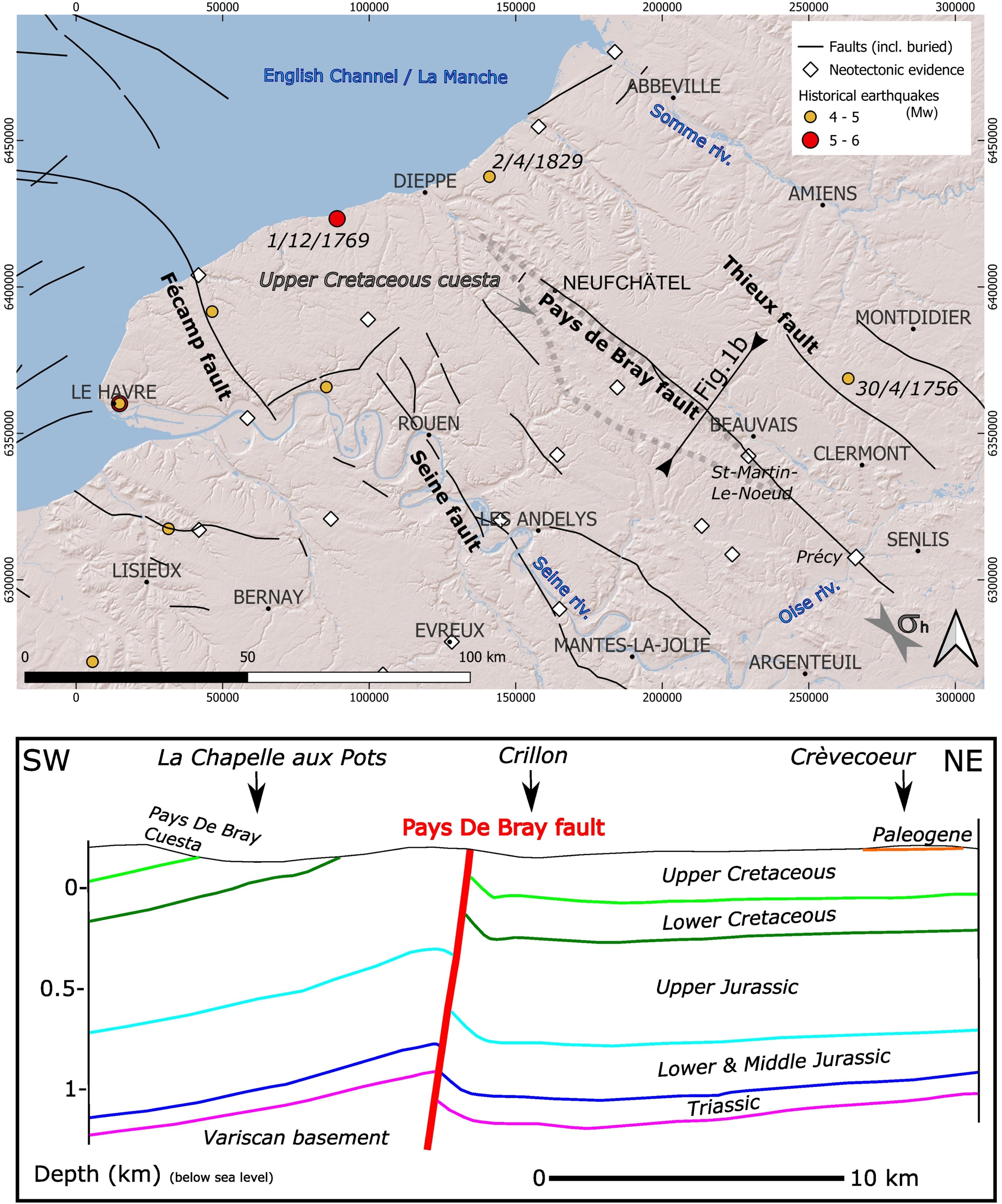
Here, we present evidence suggesting the activity of the Pays de Bray fault and related anticline (or an associated secondary structure) during the Upper Pleistocene (Weichselian). The region lacks high-quality outcrops that would allow for the description and analysis of tectonic history over the past few million years. As in other parts of France, we leverage stratigraphic work conducted during archaeological excavations, such as those at Biache-Saint-Vaast in the north of France (Colbeaux et al., 1981). Specifically, we draw on stratigraphic investigations carried out in 1993 along the excavation of the RN-31 road on the periphery of Beauvais, at the “La Justice” hill (hereafter named BLJ). We describe and analyse a site exhibiting brittle deformation features affecting a Upper Pleistocene pedosedimentary sequence including aeolian sands, clayey-sandy slope deposits and paleosols, and extending through Tertiary layers (glauconitic sands of the Thanetian) and Upper Cretaceous bedrock (Campanian chalk). The aeolian sands, making the base of the Quaternary sequence, yields a rich Middle Palaeolithic archaeological horizon dated to about 60 ka using thermoluminescence (TL) dating on heated flint artefacts.
This work represents a significant contribution to the national effort initiated in recent years under the Epos-France Transverse Thematic Action on Seismicity (Baize and Ritz, 2022). Accumulating such information will improve the characterization of regional seismic hazard and ultimately advance our understanding of intraplate deformation processes, which remain poorly understood (Mazzotti et al., 2020).
In addition to a precise stratigraphic description, we present detailed chronological data and outline correlations with the regional Upper Pleistocene reference sequence (Antoine, Coutard, et al., 2016). When considered in the context of the regional structural framework, these results provide new insights into Quaternary tectonic deformation associated with the Paris Basin’s major structure—the Pays de Bray fault and related anticline—and likely its associated buried crustal fault.
2. Regional tectonic background
2.1. The Pays de Bray fault and anticline
The Paris Basin is embedded within a vast Meso-Cenozoic sedimentary domain characterized by a broad monocline structure dipping toward the depocenter to the east/south-east. This overlies a Paleozoic and Proterozoic basement that was structured during the two major Upper Paleozoic tectonic phases—the Caledonian and Variscan orogenies (Gély et al., 2014). At the surface, the Paris Basin is intersected by several tectonic structures, one of the most significant being the Pays de Bray fault and related anticline, which extends over 110 km from Saint-Vaast (20 km south of Dieppe) to Coye-la-Forêt, 10 km south-west of Senlis (Figure 1). The anticline is asymmetric, with a steep northeastern flank. It has been demonstrated that this fold is associated at depth with a major fault—the Pays de Bray Fault—which causes relative uplift of the southwestern block. This is illustrated by the ECORS seismic profile, which clearly shows a significant south-dipping discontinuity at depth (Cazes et al., 1985).
According to seismic tomography (Averbuch and Piromallo, 2012), the Bray structure lies vertically above a remnant of a Variscan lithospheric slab and corresponds to a paleoslab tear fault. This megastructure separates two lithospheric domains rejuvenated during the Upper Paleozoic, within which the roots of the Variscan orogen have been flattened to similar depths on either side. On a larger scale, Averbuch and Piromallo (2012) extend this deep-seated Bray structure to the Wight Fault, though this continuity does not appear to be confirmed in the sedimentary cover, particularly along the southern margin of the offshore Dieppe-Hampshire Tertiary Basin (Hamblin et al., 1992; Jollivet-Castellot, 2018), contrary to the proposal by Wyns, Duperret, et al. (2016). Instead, the Bray structure seems to branch westward within the sedimentary cover as inverse or fold structures with a more E–W orientation, potentially connecting to extensions of the Fécamp Fault or structures bordering the Channel Basin. These relationships are not confirmed in the Paleozoic basement (Jollivet-Castellot, 2018).
While geological maps do not indicate any significant structures near the coastline Duperret et al. (2012) propose vertical reactivation with uplift of the eastern block in the Dieppe area, based on outcrops observed in coastal cliffs. Southeast of the surface-expressed fold, deep geophysical data—particularly gravity data—have led some authors (Autran et al., 1986; Lefort and Agarwal, 1996) to consider a deep structural continuity between the Bray structure and the Vittel Fault, which would separate the Saxo-Thuringian (to the south) and Rheno-Hercynian (to the north) Variscan zones (Ballèvre et al., 2009). Geological maps reveal a fault bordering the steep northeastern flank and a few minor oblique E–W faults. This E–W direction aligns with anomalies derived from 3D gravity modeling, which places deep E–W anomalies in the basement beneath the Beauvais area (Alessandrello et al., 1983).
From the Triassic to the Upper Cretaceous, the Bray Fault was a syn-sedimentary normal fault, subsiding the southwestern block (Guillocheau et al., 2000). The so-called Pyrenean inversion, marked by uplift and significant flexure of the southwestern block (Beccaletto et al., 2011), is also reflected in sedimentary facies changes in Paleogene layers (Blondeau, Cavelier, et al., 1964). Seismic sections show that the fault reaches the surface in the central part (Figure 1b) (Gély et al., 2014) but does not propagate markedly into the shallowest layers toward the tips, such as in the Oise Valley (Beccaletto et al., 2011). Instead, it manifests as an asymmetric fold, particularly obvious on large-scale geological maps. The seismic section in the Oise Valley shows a 0.15 ms TWT offset (ibid.), which could correspond to an inverse displacement of approximately 150–200 m at the level of the Lower Cretaceous. At the surface, the anticline is asymmetric, with a gently dipping southwestern flank (5°–10°) and a steeper northeastern flank, reaching up to 45° in the Cretaceous. The dips diminish rapidly toward the synclinal trough associated with the anticline along the Thérain Valley.
To the south of the fold, in the Précy quarry, we identified strike-slip faulting along WNW–ESE planes with dextral slickenlines developed on reddish weathering clays (Figure 1a for location). These faults are locally bound to decametric karstic depressions filled with deformed Quaternary sediments (Figure 2). The chaotic character of the deformation features in the sands is probably related to gravitational and/or periglacial processes during the karst depression collapse; however, the colocation of the Tertiary/Quaternary karst and the sharp-shaped fault could indicate a Quaternary fault rejuvenation. Closer to Beauvais to the north, (Wyns, 1980) shows that the deformation associated with the fold, such as dextral motions along brittle fold-related faults, particularly in the Saint-Martin-le-Nœud quarry (Figure 1a), is compatible with post-Cretaceous N–S shortening. This contraction has recently been dated between ∼25 and 50 Ma on the Weald-Boulonnais area, in the northern part of the Paris Basin (Blaise et al., 2025).
Deformation features of the chalk and karst deposits in the Précy-sur-Oise quarry (observations done in 2000). (A) The N110° E-striking fault zone delineates a karstic cavity and its infilling; (B) several secondary planes related to this fault zone show dextral calcite slickenlines; (C) internal deformation (faulting and tilting) of karstic infilling (redeposited loess and sandy loess) is related to sinkhole development in the karstic void.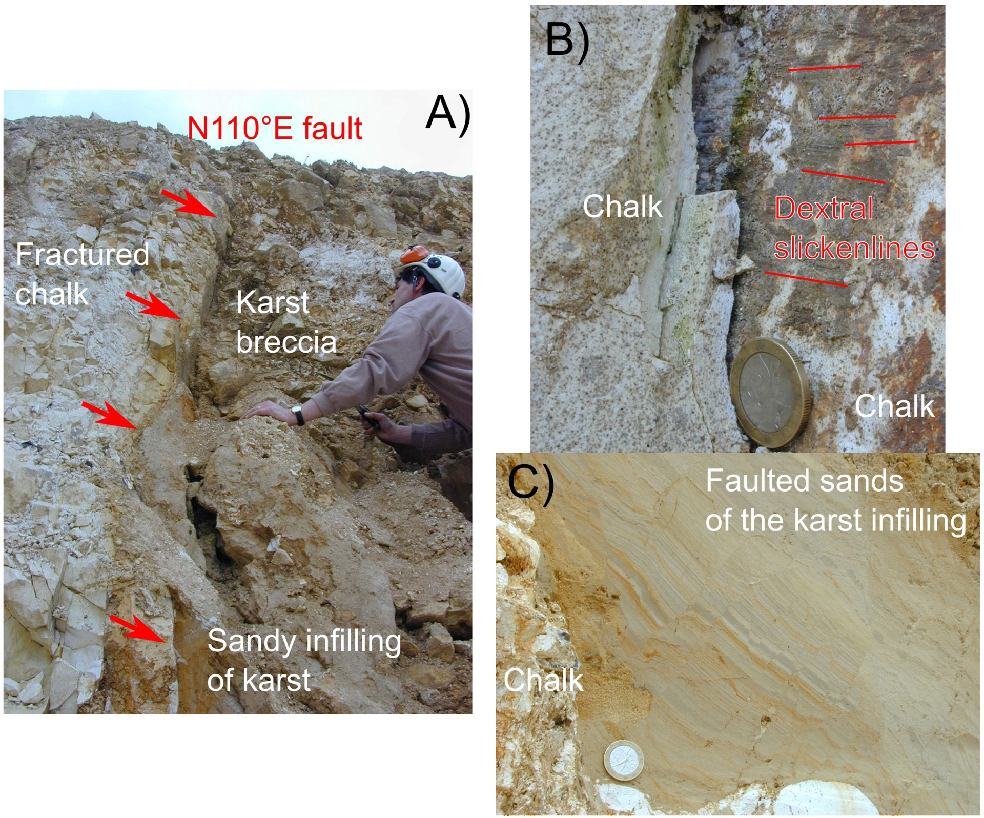
The Beauvais “La Justice” (BLJ) study site is located approximately 6 km east of the Pays de Bray anticlinal axis, above geophysical anomalies that may correspond to buried faults in the substratum.
2.2. Recent and current deformation, seismicity
In the Paris Basin, there is a general consistency in GNSS velocity directions, resulting in a significant NE–SW shortening of approximately 1 × 10⁻⁹ yr−1—a value similar to that observed around the Cévennes Fault (Masson et al., 2019). Vertical velocities indicate generalized subsidence (∼−0.3 mm⋅yr−1), except around Paris. The amplitudes of seasonal signals are more pronounced in this region than elsewhere in France, suggesting that hydrological processes may contribute to the observed deformation. In terms of stress data, there is a paucity of relevant information due to the absence of recent earthquakes. However, by extrapolating available breakdown borehole data from the southeast part of the Paris Basin, it can be inferred that the maximum horizontal stress (𝜎Hmax) is oriented NW–SE, similar to the Pays de Bray structure (Figure 1). To explain how significant strain can occur with such low seismicity, Petit et al. (2019) propose that the thick Mesozoic sedimentary pile of the Paris Basin could act as a “sticky layer”, binding together the basement rocks and increasing crustal cohesion, thereby preventing failure. Nevertheless, the broader region has experienced historical earthquakes of moderate significance, some of them causing damage. The strongest recorded earthquake in the region is the Veules-les-Roses earthquake on December 1, 1769, with its SISFRANCE (the national reference for historical seismicity, https://sisfrance.net/) epicenter situated on the English Channel coast, 20 km west of the blind Bray structure, with a poor location quality D (uncertainty up to 50 km). With a high epicentral intensity (Io = 6.5), its magnitude and depth were estimated at Mw 5.1 and 14 km, respectively (Manchuel et al., 2018). In the same region, the Bacqueville earthquake on April 2, 1829, produced moderate effects (epicentral intensity of 5), with an estimated magnitude and depth of Mw 4.3 and 16 km, respectively (ibid.). While these earthquakes do not appear to be directly linked to the Bray structure, their large uncertainties in their epicentral locations prevent definitive conclusions.
Blondeau, Cavelier, et al. (1964) mention an earthquake that supposedly occurred on April 27, 1910, in Noailles (see Figure 3 for location), thus possibly related to the Pays de Bray fault, citing Lemoine (1911). According to this account, the event was strong enough to cause the collapse of a building in Ponchon (see location in Figure 3). However, Rothé (1976) associates this event with local intensities of 5.5 in Laboissière-en-Thelle and 4.5 in Boncourt, a portion of Noailles municipality, and questions the narrative of a building collapse in Ponchon. According to this further interpretation, the 1910 Noailles earthquake would be a more moderate event than proposed by Lemoine (1911). The SISFRANCE database, however, classifies this event as a “false earthquake.” Actually, a brief search in regional and national press archives via Retronews (https://www.retronews.fr/)—a tool of the Bibliothèque Nationale de France—, reveals a chronicle that may correspond to a different event in 1910. A paper from “L’Indépendant Rémois” (May 5, 1910) reports a several-second tremor felt on the night of May 3–4, 1910, in Noailles, Ponchon, and Laboissière, causing no damage. Thus, there could effectively be an earthquake in the Noailles area potentially related to the fault and related anticline activity, but at a different time and a lower intensity than suggested by Lemoine (ibid.).
Location map of the BLJ site in its local geological context. The information includes fault and fold axes traces, stratigraphic labels, all of them from the French geological survey database (BRGM) (c1: lower Cretaceous; c2: upper Cretaceous; e1: Paleocene; e2: Eocene; q3: Holocene). Geophysical information is from BRGM (regional scale gravity anomaly) and from Alessandrello et al. (1983) = (AEA, 1983) (secondary axis of gravity anomaly). Town names underlined in white locate the 1910 earthquake information discussed in the text.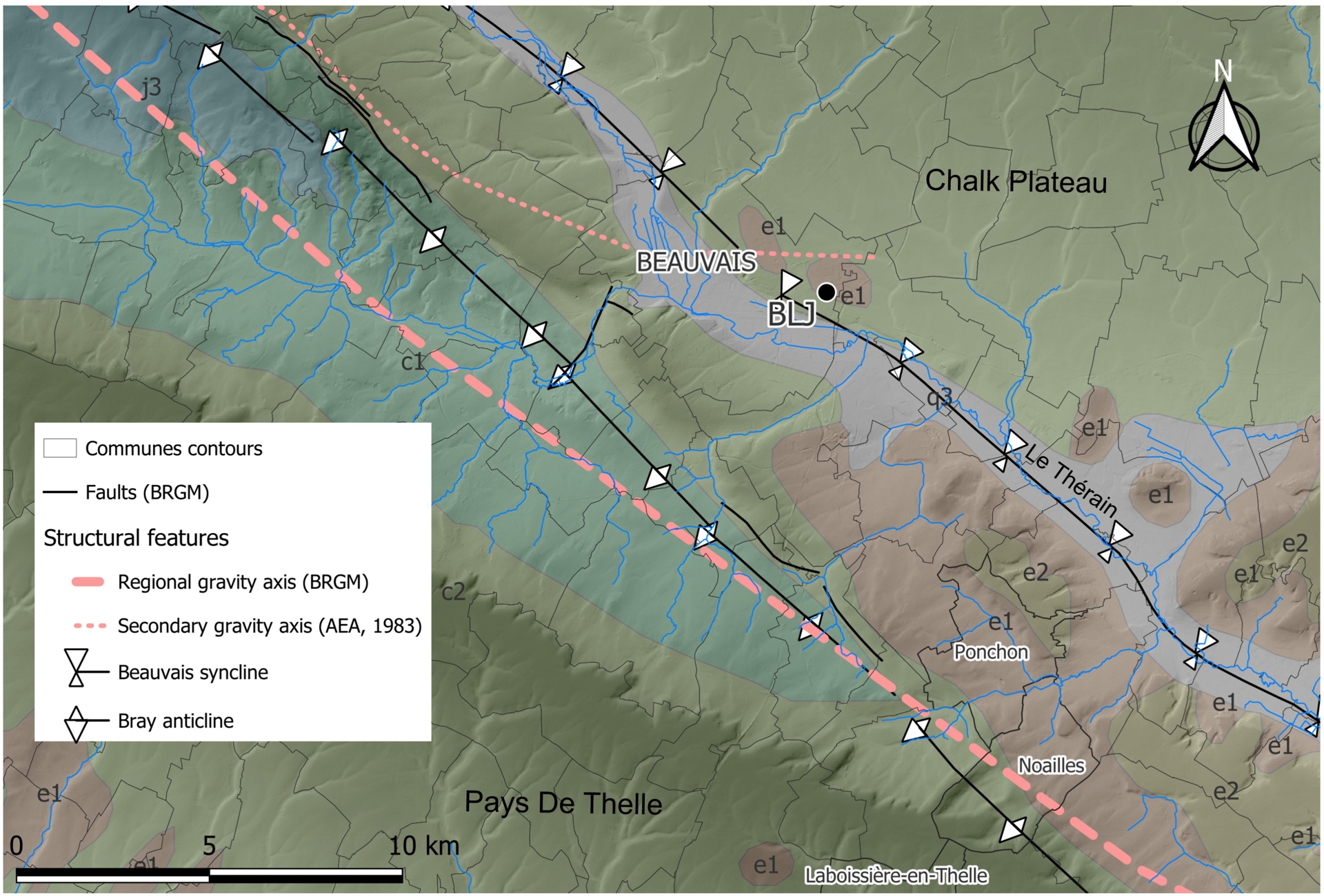
Finally, the Breteuil seismic sequence, about 25 km northeast of Beauvais, culminated on April 30, 1756, with the Wavignies earthquake (epicentral intensity 6), estimated at Mw 4.4 and 11 km depth (Manchuel et al., 2018). This earthquake is rather well constrained (quality B, location uncertainty ∼10 km), suggesting a possible association with a basement fault beneath the secondary NW–SE to NNW–SSE Thieux anticlinal axis (see Figure 1 for location).
Several geomorphological indicators have led several authors to propose that the southern flank of the asymmetric Pays de Bray anticline is uplifting (Blondeau, Cavelier, et al., 1965; Larue, 2005; Larue, 2000; Wyns, 1977). The Oise River, a major tributary of the Seine, crosses the structure almost perpendicularly, which would presumably induce vertical movement of the southwestern block. The Oise and its tributary valleys exhibit upstream congestion near the anticlinal axis, with the river narrowing and shifting southeastward as it crosses this axis. Concurrently, valley-floor alluvium appears to thin along the anticlinal axis. Based on statistical analysis and rigorous extrapolation across the entire Oise Valley Grimaud et al. (2025) conclude that this narrowing and deepening of the valley floor—previously highlighted upstream of Beaumont-sur-Oise, a village a few km SW of Précy, by Larue (2000)—shows a geometry consistent with the Quaternary uplift of the Bray anticline. The increased elevation of the chalk substratum at the Bray anticline area, more pronounced than in other areas of the same valley, is compatible with active uplift; however this fluvial pattern change could also be explained by local lithological changes, transitioning from chalk to soft Cenozoic sandy or clayey sediments. Furthermore, similar variations in substratum altitude at the watershed scale are clearly linked to meandering patterns or confluences (Grimaud et al., 2025). According to Larue (2005), the uplift of the anticlinal axis may also be responsible for enhanced upstream incision of valleys flowing south-southwestward along the southern flank of the anticline between the Oise River and Beauvais, without any lithological change.
Decades of geological and geomorphological research have not produced a comprehensive neotectonic catalog or demonstrated the tectonic origin of the few observations made. Baize, Cushing, Lemeille, Granier, et al. (2002) listed a series of mostly structural or geomorphological indicators, offering low confidence in terms of active tectonics, and it does not reference any paleoseismicity clues in the Seine-Maritime, Eure, Somme, or Paris regions, including the Pays de Bray structure which is actually not included in the BDFA database (Jomard et al., 2017). The nearest confirmed evidence of recent tectonics is near another major fault in the Paris Basin—the Marqueffles Fault—in the Hauts-de-France region (Colbeaux et al., 1981).
In this context, the discovery and dating of faults cutting through Quaternary deposits and the underlying Cretaceous substratum in 1993, during a preventive archaeological excavation at the Middle Palaeolithic site of Beauvais “La Justice” (Locht et al., 1995), appear particularly significant. This finding is the subject of original development in the present paper.
3. The Beauvais la Justice site (BLJ)
3.1. Geological context
The BLJ site is located on the southwestern flank of a Paleocene hill (denoted as e1 in Figure 3), which itself overlies the Upper Cretaceous chalk plateau (denoted as c2 in Figure 3). It is situated a few hundred meters from the asymmetric Beauvais fault-related syncline, which runs beneath the Thérain Valley. The Pays de Bray anticline extends approximately 5 km from the syncline, exposing Lower Cretaceous (c1) and Upper Jurassic (j3) formations. The anticlinal axis is accompanied by short NW–SE fault segments at the surface (Blondeau, Delattre, et al., 1982; Blondeau, Pomerol, et al., 1974; Blondeau, Cavelier, et al., 1965), primarily between Neufchâtel and Beauvais, along roughly 60 km of its length, particularly in the study area. Locally, oblique structures to the NW–SE axis—sometimes concealed—have been proposed to explain changes in the axis direction, especially in Beauvais itself (Figure 3). Significant fracturing has been documented in former quarries and mines, most of which are now filled or inaccessible (Blondeau, Pomerol, et al., 1974), except for rare cases such as the underground quarry of Saint-Martin-le-Nœud near Beauvais (Wyns, 1980; Wyns, 1977). In an old quarry between Saint-Sulpice and Abbecourt, approximately 5 km southeast of Beauvais, the fault brings Gault Clay (Albian) into contact with Turonian chalk. Further north, about 5 km west of Beauvais, in the former sandpit of Saint-Germain-la-Poterie, deltaic to continental sandy-clay facies of the Lower Cretaceous (“Wealdian” facies) are affected by a network of low-displacement faults and significant flexuring of the overlying Barremian clays.
The former quarry of the La Justice hill is the type locality of the Bracheux Sands (“Sables de Bracheux”), a stratigraphic milestone of the Thanetian stage (end of the Paleocene) in the Paris Basin (∼55 Ma) (Wyns, Perreau, et al., 1981). Despite being internationally recognized as a geological heritage site since the early 1950’s, the quarry has been intensely exploited afterwards and there has not been a proper outcrop in this old sandpit for many years (see http://www.donnees.picardie.developpement-durable.gouv.fr/IMG/File/patnat/sites/60-02.pdf). Resting unconformably on Campanian chalk, the quarry once exposed a conglomerate of green-gray glauconitic sands with flint pebbles, overlain by approximately 5 m of fossiliferous yellowish-grey sands, capped by a 1-meter-thick layer rich in marine bivalve and gastropod fossils (https://www.musee-delapparent.com/fr/tiroirs/8-b-12-thanetien-bracheux-bassin-de-paris-france).
Regarding Quaternary formations, this sector of the Beauvais plateau is characterized by a very thin (or locally absent) loess cover overlying an irregular layer of clay with flint (“argile à silex”) derived from the dissolution of the underlying Upper Cretaceous chalk. Numerous test-pits conducted in 1992 along the A16 highway confirmed this observation (Antoine and Coudret, 1991) revealing a highly discontinuous loess cover, generally less than 1 m thick, resting on the clay with flints layer. The highly irregular thickness of this layer results from multiple phases of chalk dissolution (sinkholes/dolines) during temperate interglacial and early glacial periods (Antoine, Coutard, et al., 2016), as well as cryoturbation (chalk cryo-injection) during permafrost degradation in full glacial conditions (Bertran et al., 2017). Significant loess-paleosol sequences (3 to 4 m on plateaus, locally 5 to 7 m on east-northeast-facing dry valley slopes) are only found ∼30 km to the north-northeast (Fransures region) (Antoine, 2019).
Finally, according to “Banque du Sous-Sol” borehole database accessible online (https://infoterre.brgm.fr/), the Weichselian-Holocene fill in the Thérain Valley reaches ∼8 m in thickness within the Beauvais urban area (boreholes BSS000GWLU and BSS000GWHB). Recent prospection work in the Warluis gravel quarries, a few kilometers upstream, indicates a relatively thin and condensed (1 to 3 m max.) Weichselian Late Glacial and Holocene sedimentary infilling (Coutard et al., 2010). Two additional boreholes downstream of Beauvais at the wastewater treatment plant (borehole BSS000GWKW) reveal chalk at depths of 7.5 m (T782626) and 6.80 m (T782628). A piezometer in the Chouvet quarry provides equivalent values but over Tertiary sands at the base (S417542 = BSS004ASNU).
3.2. Pleistocene stratigraphic sequence
3.2.1. Site overview: the Palaeolithic site of Beauvais La Justice
The Palaeolithic site of Beauvais La Justice (49°25′53.89′′N, 2°7′23.28′′E) is situated on the edge of a plateau overlooking the right bank of the Thérain Valley, approximately 3 km upstream from the city centre of Beauvais. Located at an elevation of 89–90 m a.s.l. (NGF reference), 30 m above the river, and 600 m north of the slope break of the chalk plateau, the site occupies the northern edge of the La Justice hill, a Tertiary remnant composed of Bracheux Sands (Thanetian). We analysed the LiDAR Digital Elevation Model (DEM) available for the study region (open-access data: https://cartes.gouv.fr/telechargement/IGNF_MNT-LIDAR-HD) (Figure 4). The flat topography of the Chalk plateau is locally cut by smooth NNE–SSW talwegs flowing southward to the Thérain Valley. Several circular depressions, weakly expressed (maximum vertical relief of 1 m) and of limited size (diameters less than 50 m), were identified in the vicinity of the study site, more than 500 m to the north, east, and south. In the western quadrant, the topography is heavily altered by anthropogenic modifications, preventing the identification of natural structures of comparable size. These circular features may correspond to partially infilled sinkholes of karstic origin (dolines). Additionally, a morphological trace, oriented in a direction consistent with the faults observed at the site, extends eastward. We consulted the past aerial pictures (https://remonterletemps.ign.fr/) and this suggests that the origin of this feature is very probably related to agriculture works, as it aligns with the boundary of a former parcel limit or track as shown in the 1950 aerial photo.
(a) DEM and aerial view of the Beauvais la Justice area with location of the excavation site along the RN-31 road (DEM from Géoportail; aerial view from © Google Earth image) and the former “Sables de Bracheux” sandpit. DEM shows several topographic features that illustrate the strong anthropogenic control of landscape. The origin of depressions is unknown. (b) Map of the excavation of palaeolithic layers at Beauvais la Justice with the location of the two main stratigraphic profiles (P1 and P2), a detailed log from P1, the location of the exploration pit regarding to P2 and the drawing of all the fault strands (red lines).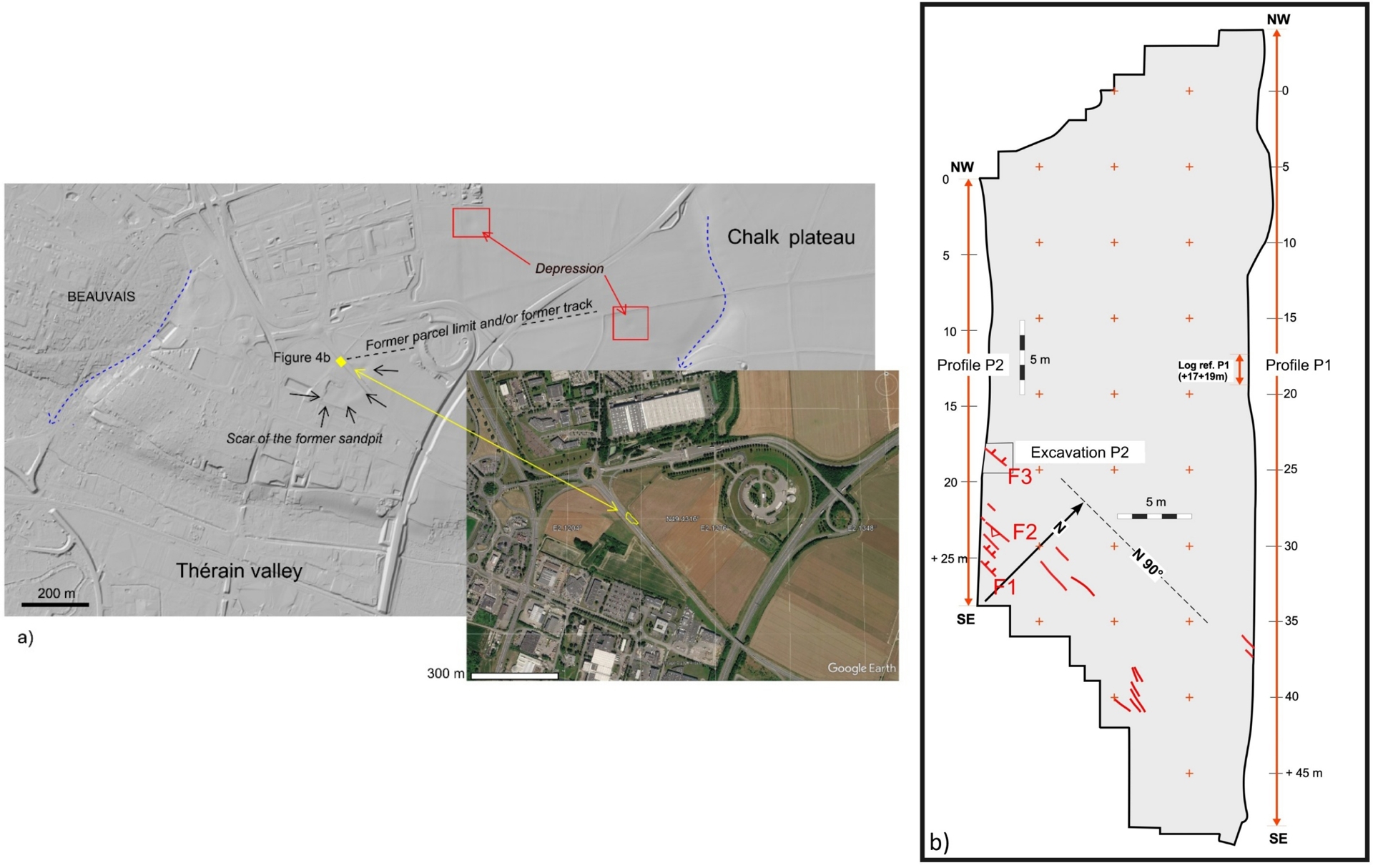
The site was discovered in 1993 by J.-F. Pastre during archaeological prospection surveys conducted prior to the construction of a bypass connecting the RN-31 (Beauvais-Clermont) to the A-16 highway (Figure 4). The Beauvais La Justice site (BLJ) underwent an extensive excavation campaign lasting over five months (Figure 5A), documenting Palaeolithic material in sandy layers (Figure 5B), a rich fauna (Figure 5D, E) and deformation features (Figure 5; Plate C) (Locht et al., 1995; Michel et al., 1999).
General and detail information about the Beauvais La Justice site. (A) General view of the archaeological excavation at Beauvais La Justice (March 1993) with the location of the southern part of profile P1(Photo J.-L. Locht). (B) Close-up of unit 6 (central part of the excavation) (Photo P. Antoine): U6a—laminated aeolian sands with aeolian ripples; U6b—Homogeneous aeolian sands with ripples and abundant reworked fragments of Tertiary marine mollusc shells and an in situ Middle Palaeolithic archaeological level dated at 55.6 ± 4 ka at the base; (C) photo detail of a fault with an apparent normal throw of 14 cm affecting the Quaternary sands of Units U5 and U6 and the Tertiary green sands (Bracheux Sands: Sbx) (Photo P. Antoine); (D) close-up of remnants of mammoth teeth (photo J.-L. Locht); (E) reindeer antler and flint artefact from the lower archaeological level (base of U6b) (Photo J.-L. Locht).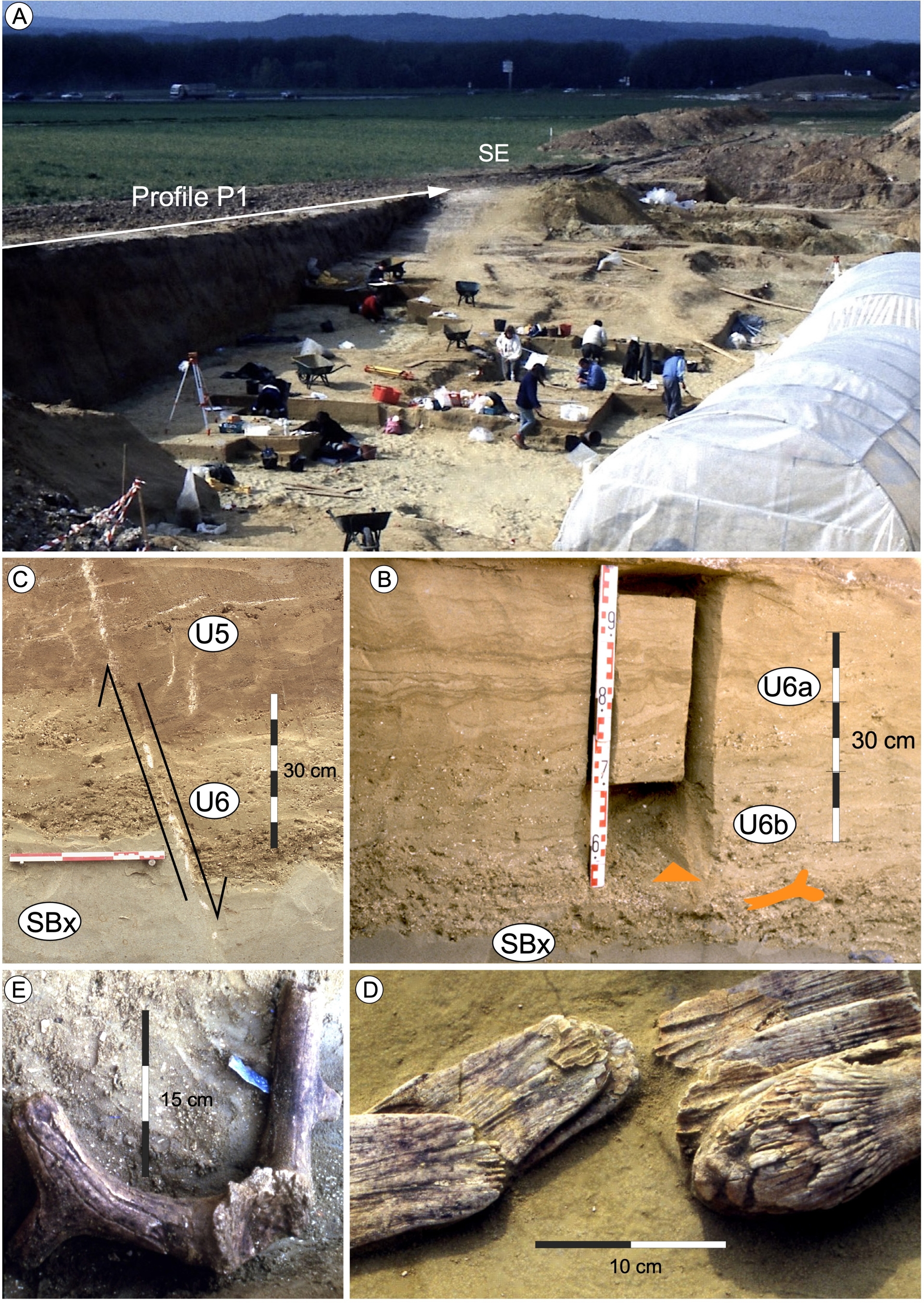
The BLJ site represents one of the few documented examples of Neanderthal occupation dating to the Weichselian Lower Pleniglacial (∼60 000 years ago) in northern France (Locht et al., 1995). The lithic assemblage is characterized by discoidal core reduction, with tools including simple scrapers and pseudo-Levallois points (ibid.). During the 1993 excavation campaign, over 13 000 flint artifacts and many large mammal bone remains were recovered from a total excavation area of 763 m2. Evidence of fireplaces, including heated flint flakes and blocks, as well as charred bone fragments, was also identified. The heated flints provided a reliable and precise thermoluminescence (TL) date for the archaeological layer embedded within a wind-blown sand deposit rich in reworked Tertiary shell fragments (Unit U6b, Figure 5B and Figure 6). The high concentration of carbonate debris facilitated the exceptional preservation of large mammal bone remains in an otherwise acidic sandy environment, where such remains are typically degraded (Figure 5D and E).
Stratigraphic and chronological framework of the Beauvais la Justice site. (A) Profile P1 with the location of the reference log (B), and of the area affected by faults (ZF) to the SE end of the section (description of the units: see text). (B) Reference log of BLJ site (see text for explanation). (C) Stratigraphic correlations between Beauvais “La Justice”, the regional reference section of Villiers Adam “Le Chamesson” (Antoine, Bahain, et al., 2003, modified) and the global reference sequence for Last Glacial loess-palaeosols records in northern France (based on Antoine, Coutard, et al., 2016, modified: last 60 000 years only). Tertiary Bedrock: SBx: Bracheux sands (Thanetien); SBp: Beauchamp sands (Stampian). Quaternary sequence (lower part not represented): 1: surface soil; 2: homogeneous calcareous loess; 3: Cryoturbated humic tundra gley (Nagelbeek tongue horizon); 4: carbonated laminated loess with cryo-desiccation micro-cracks; 5: cryoturbated tundra gley doublet with intermediary loess; 6: homogeneous calcareous loess; 7: cryoturbated tundra gley horizon and large ice-wedges network; 8: arctic brown soil; 9: sandy silts or calcareous loess; 10: greyish tundra gley horizon; 11: Greyish arctic meadow soil horizon; 12: Boreal brown soil horizon; 13: heterogeneous bedded slope deposits and sandy silts (thermokarst gully infilling); 14: homogeneous calcareous loess; 15: thin tundra gley doublet including a calcareous loess unit; 16: homogeneous brownish non-calcareous colluvial silts/incipient soil (arctic meadow horizon). Graphic symbols. (A) Ap horizon of topsoil; (B) Bt horizon of topsoil; (C) Calcareous loess; (D) Bw horizons of Boreal to Arctic brown soils; (E) Tundra gley horizons (GL Hz, Gelic gleysols); (F) Weak greyish arctic-meadow soil horizon; (G) Stratified sandy loamy colluvial deposits (infilling previously incised topography or gullies). (H) Large ice wedge casts features and associated erosion features (thermokarst gullies). (MD) Major erosional unconformity.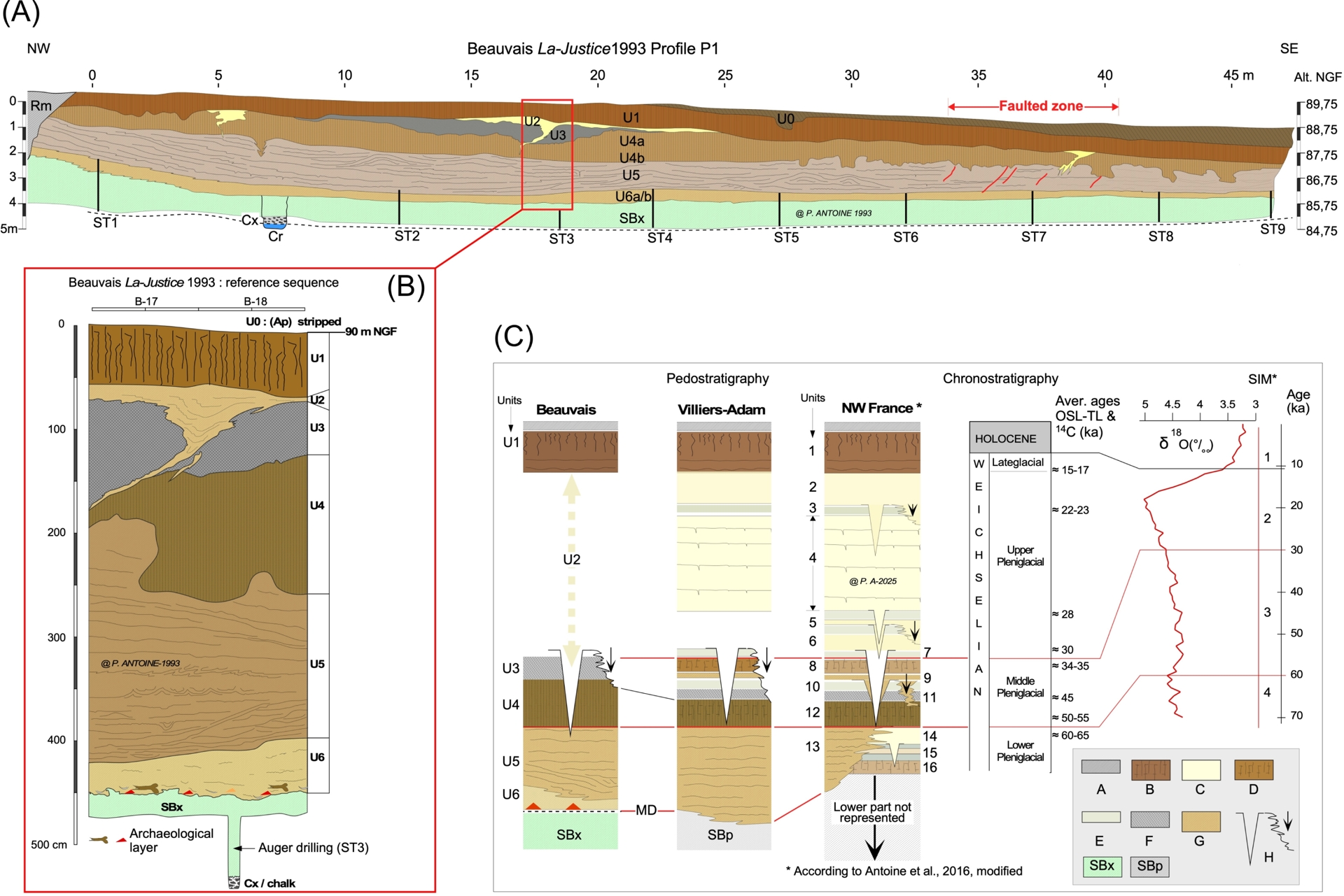
During the archaeological excavation, faults were exposed in the sections (Figure 5C), and a detailed planimetric survey of these structures was conducted (Figure 4). Additionally, two stratigraphic profiles, measuring 45 and 25 m in length (P1 and P2, respectively), corresponding to the two embankments of the future road, were documented at a 1:10 scale (Figures 6 and 7). These profiles were supplemented in the southeastern part of the northern profile (P2) by a deep test pit that extended through the Bracheux Sands down to the Campanian chalk (Figure 7). Finally, a series of hand-auger boreholes (STx) systematically identified the base of the Thanetian sands (Cx) (Figure 6A).
Focus on the Beauvais la Justice profile P2 where the fault zone (10 m wide) is well represented. (A) Stratigraphic interpretation of Profile P2 (see Figure 6 caption for description of stratigraphic units) with detail of the most external fault F1 (see B and Figure 4 for location) and close-up of the pit crossing the fault F3 (C) down to the chalk bedrock between distance 17.5 and 19.00 m along the section (description of the units: see text). The fault zone F2 is complex, with apparent normal and reverse faults of opposite dip directions, together with thickness changes of affected horizons (U6). Individual vertical separation around faults range between a few cm to 14 cm. SBx: Bracheux sands (Thanetian).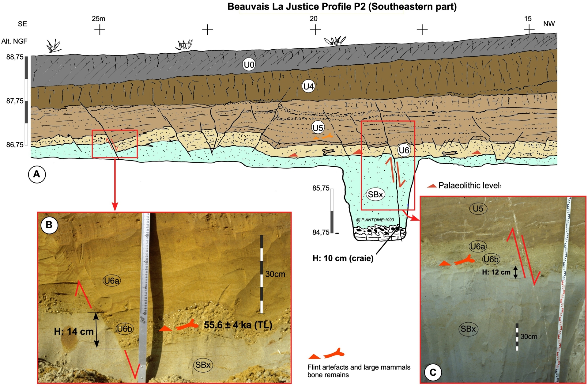
3.2.2. Stratigraphy, palaeoenvironments and dating
Description and palaeoenvironmental interpretation of stratigraphic units (Figure 6) Quaternary and topsoil units
- U0 (0.3–0.75 m): Greyish-brown silty-clay loam with scattered flint fragments. Ploughing horizon (Ap) of surface soil, primarily composed of colluvial silty-sand material, largely stripped from the site.
- U1 (50–100 cm): Reddish-brown silty-clay loam with high root porosity and diffuse prismatic structure. Bt horizon of brown leached soil (Luvisol), locally degraded by hydromorphy.
- U0 & U1 Represent the post-glacial topsoil.
- U2 (preserved only in P1, between ∼22–35 m): Homogeneous, non-calcareous, light-yellow sand infilling degraded ice-wedge casts (permafrost features).
- U3 (50–80 cm): Grey-brown clayey-humic silt with polyhedral structure. Humic Arctic medow soil horizon is heavily degraded by surface soil processes.
- U4 (100–120 cm): Non-calcareous, brown silty-clayey loam with diffuse lamellar structure, significant root porosity, and numerous ferromanganese concretions. Boreal brown type horizon (Bw) developed on silty sand during interstadial period(s). From regional stratigraphic correlation, this unit is associated with the early Middle Pleniglacial (MIS 3).
- U5 (120–220 cm): Laminated, grey-yellow sandy-clay deposits, predominantly sandy, with grey clayey layers, micro-channels (2–20 cm), small cryoturbations (2–5 cm) and rare syngenetic small frost cracks. Periglacial slope deposits reworking surrounding Tertiary sediments by hillwash and solifluction processes. Compared to present-day processes in cold regions under bare soil environments the whole unit could have deposited in a very short time (≈1000 years?).
- U6a (20–30 cm): Homogeneous, non-calcareous, yellow to light yellow-brown aeolian sand with irregular millimeter-scale darker layers (organic matter) (Plate B). This units contains the upper Palaeolithic levels in its middle section. Aeolian sands are deposited in a periglacial fully open landscape.
- U6b (5–10 cm): Light yellow-brown sand with abundant reworked marine shell fragments (Thanetian) and oblique stratification (aeolian ripples) (Plate B). The lower boundary of this unit is marked by scattered pebbles and numerous wind-polished flints. The main Palaeolithic level (Lower) is preserved at the base of U6b and locally rests directly on the Tertiary sand surface (SBx). This level yielded calcined bone fragments associated with traces of burnt soil, fireplaces fuelled by the combustion of large mammal bones. Heated flint artefacts were also found, and the thermoluminescence dating of these provided a robust chronological constrain for this layer (end of the Weichselian Pleniglacial, end of MIS 4).
Bedrock Units
- SBx (100–180 cm): Light green-grey well-sorted sands locally containing marine shell layers (Bracheux Sands, Thanetian).
- Cx (10–30 cm): Heterometric flint gravel with greenish flint and pebbles (glauconite coating) in a sandy matrix, forming the interface between the Bracheux Sands and the underlying chalk bedrock.
- Cr: In situ chalk bedrock of the Upper Cretaceous (Campanian).
3.2.3. Chronoclimatic and chronostratigraphic interpretation
The chronoclimatic interpretation of the Beauvais sequence is based on the comparison of its pedosedimentary record with the regional reference sequence for the last Interglacial–Glacial cycle (Antoine, Coutard, et al., 2016) (Figure 6C). This interpretation relies mainly on stratigraphic correlation with the Villiers-Adam reference sequence, located 40 km to the south near the Oise Valley, which provides the most complete stratigraphic record for this region at the southern margin of the loess zone (Antoine, Bahain, et al., 2003). It is further supported by available dating, particularly a thermoluminescence (TL) date on heated flints (55.6 ± 4 ka) in Unit 6, considered the most reliable.
Across the excavated area, boreholes and observations made after the excavation during road construction revealed that the Bracheux Sands (SBx) rest unconformably on the Campanian chalk, with an erosional surface that appears relatively flat and devoid of dissolution features such as sinkholes or dolines. This unconformity is marked by the Cx gravel layer, composed of green-patina flints embedded in a glauconitic sand matrix, typical of the base of the Thanetian transgression (Wyns, Perreau, et al., 1981).
The oldest Quaternary unit (U6b) is separated from the underlying Thanetian sands by an erosional unconformity, resulting from an episode of intense aeolian deflation. This Pleistocene deposit consists of homogeneous aeolian sand rich in reworked Tertiary marine shell fragments. Unit U6b contains the lower Palaeolithic level, characterized by knapped flints and large mammal remains. In an acidic sandy environment, these faunal remains were exceptionally preserved due to the high carbonate content from abundant reworked Tertiary fossil fragments. Faunal analysis indicates the dominance of reindeer (Figure 5E), along with woolly rhinoceros, mammoth (Figure 5D), and horse, suggesting a steppe environment with a cold, dry, and continental climate, corroborated by rodent fauna studies. The evolutionary stage of species such as woolly rhinoceros and mammoth aligns with an attribution to the early Middle Weichselian. In its middle and upper sections, Unit U6a exhibits fine, dark, wavy silty laminae (Figure 5B), indicative of nivo-eolian processes like those described in modern Arctic environments, where particles are trapped on the snow surface and deposited during spring thaw. Given this sedimentary facies, faunal content typical of a cold steppe, TL dating of heated flints (55.6 ± 4 ka), and stratigraphic correlations with the Villiers-Adam reference sequence, units U6b and U6a are attributed to the end of the Weichselian Lower Pleniglacial, corresponding to the end of Marine Isotope Stage MIS 4. This arid period, characterized by intense deflation and aeolian sedimentation, is generally poorly represented regionally. Only a few profiles, such as those at Havrincourt in northern France (Antoine, Goval, et al., 2014) and Harmignies in Belgium (Haesaerts et al., 2016), record the deposition of the first allochthonous calcareous loess, marking the Lower Pleniglacial. Dated to ∼60 000 years, these deposits coincide with the first major sea-level drop (∼−90 to −100 m) (Siddall et al., 2003), which exposed deflation zones associated with paleo-fluvial networks in the Eastern English Channel (Antoine, 2019).
Unit U5, which systematically overlies these aeolian sands, consists of a thick, laminated sandy-clay formation with scattered gravel and micro-cryodesiccation cracks. Its structure and composition are typical of a humid periglacial context, with extensive evidence of gelifluction and intense slope runoff (Figures 5 and 6). The base of this slope unit is highly discordant with the underlying U6 sands, from which it likely eroded a significant portion. Its facies, characterized by intense runoff structures with oblique, heterogeneously filled bedding, implies a large water supply which, in these arid periglacial environments, is primarily available during melting events of ice trapped in ice-rich permafrost, particularly in large ice-wedge networks. By comparison with the Villiers-Adam reference section, the U5 deposits are interpreted as those trapped in a large thermokarst incision gully cutting into the slope (Antoine, Bahain, et al., 2003). Given its stratigraphic position beneath the interstadial brown soil complex (U4–U3) and the dating of the underlying aeolian sands, the U5 deposit at BLJ, resulting from an intense and widespread slope erosion episode, serves as a marker of the Lower to Middle Pleniglacial transition. This major slope erosion event has also been documented in the Somme Valley at Morcourt (Sambourg et al., 2025), and in the Nussloch reference section in Germany (Antoine, Rousseau, et al., 2001; Rousseau et al., 2002). The end of this erosive episode marks a return to a drier environment, with slope stabilization in a context where aeolian sedimentation reactivates, favouring the deposition of homogeneous silty aeolian sands, as seen at Villiers-Adam (Figure 6C, Unit 13). Given the reduced loess dynamics in Western Europe during this period —and particularly in northern France and the Paris Basin—, the Tertiary sands constitute easily re-mobilizable material through aeolian deflation and redeposition. It is suggested that this erosive phase, which rejuvenated the topography and remobilized a large quantity of Tertiary sands, may have renewed the sedimentary stock available for aeolian deflation in the form of foot-slope spreads and/or sand bars in fluvial valleys such as the Oise or Thérain rivers. At BLJ, the end of this episode is marked by the deposition of increasingly homogeneous silty-sandy aeolian material toward the top of Unit 5, like that observed at Villiers-Adam (Figure 6C).
The BLJ sequence is subsequently characterized by a compact, brown, silty-clay loam corresponding to a Bw horizon of a particularly thick boreal brown soil (U4). Its stratigraphic position and facies suggest a correlation with the main soil constituting the base of the Saint-Acheul-Villiers-Adam Soil Complex (Figure 6, Unit 12), dated to ∼55–45 ka and attributed to the early Middle Pleniglacial (early MIS 3). Above this soil, in the eastern section (P1), a greyish-brown silty-clay loam horizon (U3) is locally observed over ∼15 m. This horizon, slightly less compact than the U4 soil, exhibits a poorly developed isohumic soil facies of the arctic meadow type, later enriched in clay due to its proximity to the topsoil Bt horizon. It is comparable to the small horizon described in the Middle Pleniglacial soil complex at Villiers-Adam (Figure 6, Unit 11), and possibly to that described at Nussloch at the top of the upper Gräselberg soil, dated to 45 000 years and attributed to the end of interstadial GI-12 in the NGRIP record (Rasmussen et al., 2014).
The end of the sequence, represented by non-calcareous yellow aeolian sands (U2), is preserved only in the fillings of large ice-wedge pseudomorphs that open at the top of the U3 soil (Figure 5). Given its stratigraphic position, the size of the associated ice-wedge pseudomorphs, and the limited sedimentary record attributable to this period in the Beauvais area, this facies is assigned to an indeterminate Upper Pleniglacial (∼30–20 ka). Its purely sandy nature likely represents an initial stage of the Upper Pleniglacial, before the deposition of typical calcareous loess became widespread. Even at Villiers-Adam, where Upper Pleniglacial loess is present, this period is only preserved in localized sedimentary traps linked to thermokarst incision valleys (Antoine, Bahain, et al., 2003, Figure 6C).
Finally, beneath a ploughing horizon (Ap/U1), locally developed on recent agricultural colluvium up to 75 cm thick toward the southeast, the BLJ sequence concludes with a thick, compact, reddish-brown Bt horizon of leached brown soil (Luvisol) on silty-clay loam. This unit represents the weathering record under a temperate oceanic climate and deciduous forest of the silty-sandy material previously deposited during the Upper Pleniglacial, following the aeolian sands of U2. Its formation corresponds to the climatic improvements of the Late Glacial and then to the Holocene Interglacial.
As shown by its truncated surface and the thickening of colluvial deposits covering it toward the southeast (U1), this soil is strongly truncated by anthropogenic erosion processes, which, according to recent studies, intensified regionally during the Bronze Age (Pastre et al., 2015).
3.3. The fault network
During the excavation and logging, numerous faults affecting part of the Quaternary deposits were observed in the southeastern sector (Figure 4), between +35 and +40 m on profile P1 (Figure 6) and between +15 and +25 m on profile P2 (Figure 7). The fractures are commonly coated by white calcite, which correspond to secondary precipitation associated with roots activity. These structures clearly cut through Units U5 and U6 and the Bracheux Sands (SBx). They were precisely mapped on the surface of the archaeological excavation (Figure 4). The surveys indicate that the fault segments span a width of 5 to 10 m, exhibiting a consistent E–W directional trend across the site and a kinematic coherence, with downthrown blocks to the north. Vertical displacements of a few centimeters to about 10 cm are documented on individual segments, which are short ranging from 1 to 5 m in length (Figure 4). They are recognized across the entire width of the excavation (25 m) at the level of the archaeological layer.
The vertical continuity of the northernmost structure (named F3) was demonstrated thanks to the excavation of a 2-meter-deep test pit along the southern end of P2 (Figure 7). In this pit dug down to the chalk, the fault cuts through Units U5 and U6, the Bracheux Sands (SBx), and the flint gravel layer forming the interface with the chalk (Cx). An apparent normal offset of 12 to 14 cm was measured on this particularly clear structure at the interface between the Bracheux Sands (green) and the grey-yellow Quaternary aeolian sands (U6a and U6b). At the base of the pit, the offset of the chalk surface is approximately 10 cm. The other main faults, labelled F2 and F1 (from north to south), were not explored beyond the Pleistocene/Thanetian interface.
The stratigraphic observations presented above demonstrate that the N-90° faults clearly affect part of the Quaternary deposits (U6, U5 and the base of U4), with maximum vertical offsets of about 10 cm on individual fault segments. The cyclostratigraphic analysis of the BLJ sequence and the dating of the U6 sands suggest that the youngest unit affected by these faults could be the base of U4, which is capped by the apparently undisturbed major core of U4. This would lead to an event attributable to the first half of the Middle Weichselian Pleniglacial, after ∼56 ± 5 ky (Figure 6). Due to the proximity to the surface and the pedological alterations associated with the post-glacial soil (U1), as well as the clayey (plastic) nature of the U4 material, it is challenging to really constrain the upper limit of the deformation which seems to stop within U4 (∼50 ky, according to regional stratigraphic correlations) and we cannot exclude that the deformation reaches the upper part of U4. Since these faults disappear within Unit 4, we infer that their activity ceased before the formation of the humic soil of Unit 3, and thus before 45 000 years ago.
4. Discussion
4.1. Origin of the deformations observed at Beauvais
In the broader regional context of northern France, the brittle structures cutting through dated Quaternary deposits, their Tertiary and Cretaceous substratum, as observed at Beauvais “La Justice”, constitute an exceptional example, alongside Biache-Saint-Vaast (Colbeaux et al., 1981). While numerous faults have been documented by various authors in the Quaternary deposits of northern France, these typically result from periglacial processes (e.g., ice-wedge casts, slope decompression) or, more commonly, from localized dissolution of the underlying chalk substratum like karst sinkholes and dolines (Antoine, Coutard, et al., 2016; Antoine and Limondin-Lozouet, 2024; Baize, Coulon, et al., 2007; Bertran et al., 2017; Van Vliet-Lanoë et al., 2017).
However, at Beauvais La Justice, no doline or karst sinkhole deformations were observed at the scale of the site, despite a systematic search for the Quaternary-Cretaceous contact during the excavation and subsequent observations during the RN-31 roadworks, which revealed a rather regular chalk surface and an absence of karst cavities or depressions in this area. While anthropogenic cavities (e.g., marl or underground quarries) can also cause surface deformations, no such cavities are recorded in the national database within the site or slightly to the north to explain the observed deformations, despite the risk classification of the municipality of Beauvais (Pannet and Schroetter, 2011). The hypothesis of a landslide linked to the proximity of a gently sloping hillside toward the Thérain river in the southwest of the section is unlikely, despite the colluvial nature of the youngest affected deposits (U5), as it would be incompatible with the northward dip of the normal faults. A periglacial origin also seems unlikely: the brittle deformations at BLJ are rooted in the substratum, are mechanically consistent from top to bottom, and bear no morphological resemblance to any periglacial structures in northwestern France, such as ice-wedge pseudomorphs, cryoturbation involutions, or sediment-filled pots. Additionally, glacitectonic deformation can be ruled out, as the region was never occupied by ice.
Thus, a tectonic origin appears to be the most plausible explanation for these deformations. In such a hypothesis, we propose an attempt to characterize and quantify the tectonic deformation. When considered as a whole, the fault zone (F1 to F3) separates two vertically offset blocks by approximately 25 cm (Figure 7). The largest vertical displacement is concentrated around fault zone F2, which exhibits a complex pattern with both apparently reverse and normal offsets and opposite dip directions. If we assume that all segments are connected at depth to a single fault, this pattern can be interpreted coherently in terms of kinematics, with a curved/listric geometry for the F2–F3 ensemble (Figure 8). When additionally considering the change of thickness and mismatching of U6 across a fault segment between F1 and F2, we could propose a lateral component of the movement. Figure 8 shows a right-lateral component without any constraint (it could be left-lateral).
Tectonic and kinematic interpretation of the P2 profile, accounting for the units and faults geometry. We highlight the major role of F2 in separating the two blocks vertically offset (0.25–0.3 m) and the secondary impact of other faults, including F1 and F3. F2 fault zone shows a complex pattern of apparent reverse and normal offset, with abrupt thickness changes and mismatching layers apart strands. This geometry could be explained by a combination of dip and strike-slip motion on curved and merging planes (F1/F2 fault zone, at least). Interestingly, the stratigraphic context constrains a probable single event deforming the Cs to U5/base of U4 pack, capped by undisturbed sediment of the U4 unit.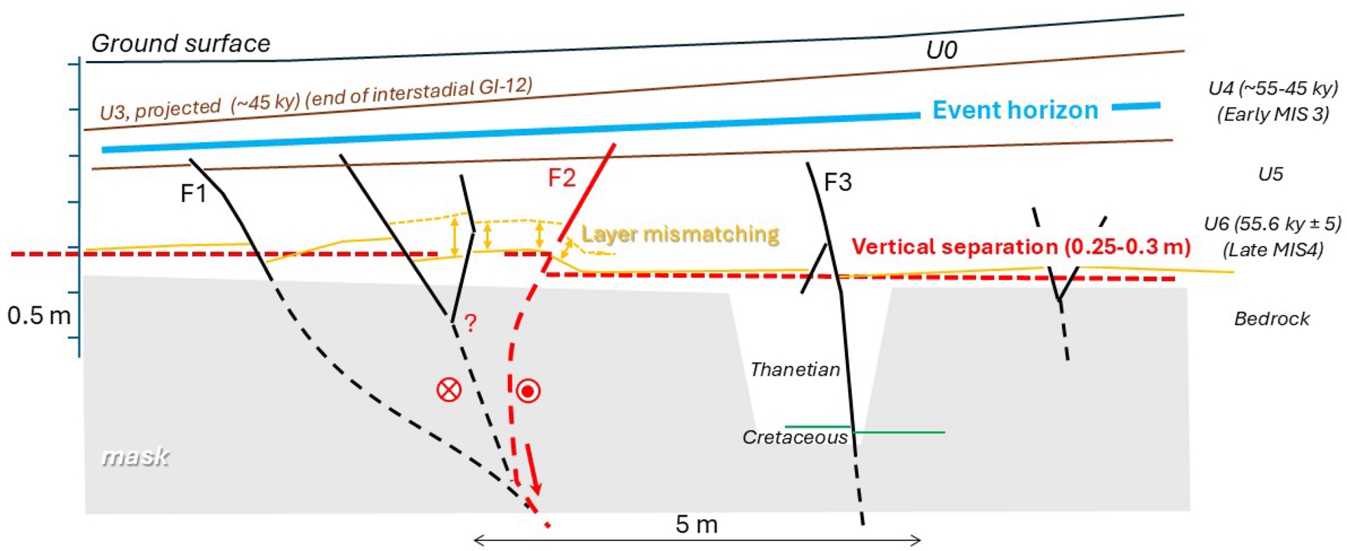
The arrangement of these structures reveals strong segmentation, with parallel meter-scale strands spaced a few meters apart, grouping into clusters. While the excavation area is extensive, it remains too limited to fully understand the organization of a potential coseismic surface rupture. For comparison, similarly complex geometries are common at similar scales, as illustrated by the 2016 Norcia earthquake (Mw 6.5) in Italy (Villani et al., 2018) where ground ruptures exhibited intricate and segmented patterns.
Therefore, the BLJ fault system may represent a localized expression of a larger, more complex rupture system, possibly linked to deep-seated tectonic structures. Further investigations, including high-resolution geophysical imaging and paleoseismic trenching, would be necessary to clarify the three-dimensional geometry and kinematic behaviour of this fault network. This study and related archeological framework would be useful to analyse those further investigations.
4.2. Implications for seismic hazard assessment
The recent age of tectonic deformations at BLJ raises questions about our understanding of seismic hazard. The region is classified as an area of very low seismicity, with no mandatory earthquake-resistant building regulation, even for critical infrastructure (buildings and bridges). Critical plants potentially belong to the same seismotectonic zone as the BLJ site according to the (Baize, Cushing, Lemeille and Jomard, 2013) seismotectonic scheme, and to date their hazard could be controlled by the reference earthquake of Veules-Les-Roses (1769). This event is characterized by an epicentral intensity of 6.5 and an equivalent magnitude/depth pair of Mw 5.1 and H = 14 km (Manchuel et al., 2018). If the BLJ observations are associated with a prehistoric earthquake involving surface rupture, questions arise in terms of seismic hazard and its potential reassessment in the region. What magnitude could this paleoearthquake have had? Which structure generated this event? What is the potential of this structure in terms of maximum earthquakes and their recurrence intervals? Could a similar feature exist elsewhere in the same seismotectonic zone and where?
The Bray Fault is absent from the French Database of Potentially Active Faults (BDFA) (Jomard et al., 2017) but described as a neotectonic structure with very low activity in the (Baize, Cushing, Lemeille and Jomard, 2013) database. It is the largest geological structure near the BLJ site, consisting of a deeply rooted fault dipping southwestward. While it outcrops only partially along its extension at depth, it likely extends to the contact between the Lower and Upper Cretaceous, approximately 5–6 km southwest of the site. This major fault is associated with an asymmetric anticline and syncline (Gély et al., 2014), with the syncline axis passing about 500 m south of the site. Gravimetric data suggest that the bedrock of the study area may include a secondary E–W transverse structure, roughly at the same latitude as another NE–SW trending brittle structure (Figure 3).
The tectonic deformations at BLJ are thus not located directly above a mapped fault but seem collocated with a fold structure and potentially above a geophysical anomaly with a same direction. One hypothesis is that those features in BLJ represent distributed deformations associated with a major coseismic rupture on a distant main fault, such as the Bray Fault. However, this fault is too distant (over 5 km), making such distributed ruptures with high amplitudes (25 cm) very unlikely. These would typically be associated with major events of magnitudes greater than 6.5 or even 7 (Nurminen et al., 2022; Visini et al., 2025), which seem unrealistic in the context of the Paris Basin.
An alternative possibility is that the observed deformations correspond to the rupture of an unmapped ∼E–W fault, a secondary crustal fault structurally related to the Bray Fault, during a significant earthquake. Using empirical scaling relationships, the magnitude of such an earthquake can be estimated between Mw 6.2 and 6.5 for normal or strike-slip mechanisms if the deformation is due to a unique event, according to the documented offset (∼25 cm) across the entire fault width (∼5–7 m) based on the Wells and Coppersmith (1994) relationship applicable to active tectonic contexts, and Mw 5.3 to 5.65 for dip-slip and strike-slip earthquakes (respectively) using Leonard (2014) intraplate scaling law. To date, we have no clear evidence of multiple events in the observed stratigraphy: we cannot confidently interpret any of the upward attenuating deformation features (Figure 7) for proper fault terminations which would attest to recurring events. Moreover, the spatial distribution of faults visible on map is not an argument of multiple events, as this pattern is commonly observed during modern Mw ∼ 5.5–6.5 earthquakes’ surveys (Nurminen et al., 2022). The geometric relationships and the ages obtained for the affected and unaffected formations, ∼55 ± 5 ka and 45 ka respectively, therefore suggest that the site records only one event since the deposition of the aeolian sands containing the Palaeolithic layer. Therefore, no usable information is available on the recurrence interval of equivalent events or the possible slip rate of the underlying fault. The available data remains too fragmentary to extend beyond the assertion of active tectonics within the last 60 ka in the region.
Regardless of the magnitude of the interpreted paleoearthquake, questions remain about the potential of the Bray Fault, even if the reported observations are not linked to it but to a peripheral structure. Large earthquakes on transform interplate and mature faults are commonly triggered by branch and immature faults (e.g. 2002 M7.9 Denali (Alaska), 2016 M7.8 Kaikoura (New Zealand) or 2023 M7.7 Pazarcik (Turkïye)) (Stein and Bird, 2024). The region of interest is under a drastically different seismotectonic environment and regime; however one could question the possibility that the potentially BLJ structure could trigger a larger earthquake on the crustalscale, (probably) mature and old buried Bray fault. Structural complexities are also thought to be a location of stress buildup at the initiation of large intraplate earthquakes (Talwani, 2017). The seismogenic thickness (10–15 km), along with the lateral and depth extent of the nearby Bray structure, thus raises questions about its capacity to generate large earthquakes capable of producing damaging ground motions and surface ruptures.
The timing and location of this event questions the triggering phenomenon. Actually, the age bracket of the event, between 55 and 45 ky, more or less coincides with the retreat of the MIS 4 Fennoscandia-British Islands icesheet that were partly covering Northern Europe (Batchelor et al., 2019). The BLJ site being located on the southern margin of this massive icesheet, it could have been influenced by glacio-isostatic adjustments (GIA) that likely modified the strain-rate and stress conditions as during and after the Late Glacial Maximum (Craig et al., 2023). MIS 4 ice sheet southern boundary is much less constrained than that of MIS 2 (Batchelor et al., 2019), its exact location in relation to the BLJ site is uncertain; however, it was at least 400 km to the north-northeast.
Even if the far-field tectonic loading may remain the long-term control of loading and mechanism of faulting, transient changes are prone to trigger seismicity on critically stressed faults, especially during the early period of post-glacial adjustment. One important consequence of such a triggering process would be that, at first glance, the hazard would have been larger at that time than during the present days and the near future (Linsalata et al., 2026). Actually, despite a large number of observations in the framework of archaeological rescue and soundings, there has never been an observation of LGM-related post-glacial event. However, as stated by Wang et al. (2021), the current “no (measurable) strain” does not mean “no hazard” in the context of a visco-elastic earth responding to a large-scale isostatic post-glacial rebound, especially dealing with a fault deeply seated in the crust like the Pays De Bray structure. In other words, the early loading of a fault, caused by GIA, may still be stored, and it may still be close to failure and available for further events.
In any case, these results encourage further detailed exploration of the potential underlying structure, using high-precision near-surface geophysical methods (e.g. ground-penetrating radar, S-wave reflection seismics, electrical resistivity tomography) and additional paleoseismic excavations, as well as a reassessment of the whole Bray Fault, which has been overlooked until now.
5. Conclusion
More than 30 years after the initial study of the Beauvais La Justice site, we report here observations concerning a fault system (N 90°) cutting across a Weichselian pedosedimentary sequence including at its base a Middle Paleolithic site preserved in an aeolian sand layer well-dated to nearly 60 ka using TL on burned flint artefacts. A re-examination of the stratigraphic sections of this site, originally analysed for paleoanthropological and paleoenvironmental purposes, from a tectonic perspective reveals that the geometry, kinematics, and spatial arrangement of the deformations—within the local morphologic context—are consistent with a tectonic origin.
In the context of heightened seismic risk awareness following the Le Teil earthquake, we emphasize the urgent need to re-examine all potential indicators of neotectonic activity documented in existing databases. It is then essential to collect evidence of potentially tectonic deformation from local geoscience stakeholders, whether they are involved in the Epos-France FACT consortium. We demonstrate here that French archaeologists and geomorphologists, who—through the national preventive archaeology law in France—have acquired unparalleled territorial knowledge of anthropogenic remains and associated stratigraphic horizons, can significantly contribute to this effort.
Moreover, to inform seismic hazard models, we argue that these data must be supplemented by broader acquisitions at the scale of associated geological structures capable of generating paleoearthquakes. This includes quantitative geomorphology and paleoseismology, as well as the exploitation of available geophysical data, whether from subsurface exploration (e.g., reflection seismics) or regional deformation quantification (geodesy or seismology).
This is particularly relevant for large nearby regional structures, such as the Pays de Bray anticline and its associated crustal fault, whose Quaternary activity remains poorly characterized. A comprehensive, multidisciplinary approach is necessary to refine seismic hazard assessments and better constrain the potential for future earthquakes in intraplate regions like France.
Acknowledgments
We sincerely thank Klaus Reicherter, Brigitte Van Vliet-Lanoë and an anonymous reviewer, as well as Eric Calais, Editor-in-Chief at the journal “Comptes Rendus Géoscience Earth Sciences”, for their insightful comments and constructive feedback. They greatly contributed to improving the quality of this manuscript. This work is part of the collective effort of the national community gathered within the Active Faults Study Group, Epos-France/ATTS/FACT. Archeological survey was led by J.-L. Locht with continuous stratigraphic monitoring by P. Antoine (Figures B, C, D; Plate A). Large mammal remains were analysed by P. Antoine (CNRS-USTL-Lille), while thermoluminescence dating of archaeologically heated flints was performed by N. Debenham (TL Survey Nottingham). Concurrently, V. Michel and J.-J. Bahain (IPH-MNHN, Paris) conducted U/Th and combined U/Th-ESR dating on dental enamel of large mammals, yielding results consistent with those obtained from thermoluminescence.
Declaration of interests
The authors do not work for, advise, own shares in, or receive funds from any organization that could benefit from this article, and have declared no affiliations other than their research organizations.