


 CC-BY 4.0
1. Introduction
Before the advent of instrumental seismology at the end of the XIXth century, knowledge of earthquake phenomena was based entirely on the analysis of macroseismic effects of past earthquakes. In France, the first macroseismic survey may have been conducted in 1783 by the Academy of Dijon for an earthquake in Burgundy [Schlich 1984], and earthquake catalogues published by Alexis Perrey (1807–1882) have been the main source of information for years [Fréchet 2008]. Indeed, at the beginning of the XXth century, very few instrumental data were available. Promoting the installation of new seismographs and facilitating international exchange of the data was then a major challenge for seismologists. For this purpose, Georg Gerland, professor of Geography at the German University of Strasbourg, promoted the idea of an international association of seismology [Rothé 1981]. The association officially started in 1904 with its central Bureau at the University of Strasbourg (Bureau central de l’association internationale de sismologie (BCIS)).
At that time, seismology was much less developed in France than in other European countries like Germany, where Strasbourg was located until 1918, Italy, or the United Kingdom. In 1909, during the third meeting of the permanent commission of BCIS, the recently appointed director of the French “Bureau central météorologique” (BCM) in Paris, Alfred Angot, announced the May 23, 1908, governmental decision, creating a seismological service for “France and its colonies” [Angot 1909]. Its seismographic station was fixed in Parc St Maur near Paris, while stations were already functioning in the cities of Besançon, Marseille, Toulouse, Lille, and in Puy-de-Dôme near Clermont-Ferrand. A 7th station was also planned to be installed in Algiers. The Lambesc (Provence) June 11, 1909 earthquake was the opportunity of launching the first large BCM macroseismic survey made with questionnaires [Angot and Lemoine 1910; Fréchet 2008]. By “questionnaire” in the text, we mean a document that allows you to answer a series of open-ended, semi-open-ended, or tick-box questions (more contemporary version of survey questionnaire).
In 1919, at the end of World War I, Edmond Rothé took the chair of geophysics at the new French University of Strasbourg. He became responsible for both the international association and its central Bureau. The former BCM seismological service was moved to Strasbourg and the French government decided on July 28, 1921, the creation of the “Institut de Physique du Globe de Strasbourg” (now “Ecole et Observatoire des Sciences de la Terre” (EOST)) and its “Bureau central sismologique pour la France et les colonies” (BCSF).
Since 1921, macroseismic questionnaires are collected by the BCSF, except during a few years between 1978 and 1986 when the French “Bureau de recherches géologiques et minières” (BRGM) was in charge of this task [Roger 2021]. These questionnaires were fulfilled by local authorities and/or individuals after each felt earthquake. Observations derived from this macroseismic information (intensities) and mixed with instrumental seismicity are published in different forms and in a more or less homogeneous way between 1920 and 1970.
Considering the renewal of interest in macroseismic data for seismic hazard investigations, the present paper aims at summarizing how macroseismic observations were collected and have been processed in France by BCSF over the past 100 years.
2. Macroseismic scales
Effects of an earthquake on persons, objects, buildings, and sometimes on the natural environment, are commonly evaluated in terms of macroseismic intensity, an indicator that characterizes the severity of the seismic ground shaking in a given restricted area. By convention, intensity is expressed by an integer number written in Roman letter. Macroseismic scales are the tools allowing any analyst to fix the intensity degree in a conventional way. Before 1921, the 10-degree Rossi–Forel scale [De Rossi 1883] was the macroseismic standard adopted in France. This scale did not consider the vulnerability of buildings for estimating the ground shaking, and this question remained for years as an important issue for interpreting data collected in past macroseismic survey.
An important step in the concept of macroseismic intensity is due to Cancani [1904]. He noticed that the ground “accelerations increase following a geometrical rule with a common ratio of two” as compared with intensity. As a consequence, macroseismic intensity behaves as the logarithm of the ground acceleration, which doubles between two degrees of intensity. This makes him suggesting that the former 10-degree Rossi–Forel scale should be extended to twelve degrees in order to cover the most devastating earthquakes [e.g. Cara et al. 2008]. Mercalli [1902] and Sieberg [1912, 1932] followed Cancani’s suggestion, and introduced a detailed description of seismic effects in the scale. In Europe, and in France, in particular, the 12-degree Mercalli–Cancani–Sieberg (MCS Scale) has been broadly used, and many successive versions of the modified MCS are still in use worldwide, for example, in Italy and North America, under the name “modified Mercalli scale” [e.g., Wood and Neuman 1931]. In France, between 1955 and 1973, J. P. Rothé used a scale almost similar to the MCS called EMI scale (Echelle macrosismique internationale), notably for his participation in the edition of the French building code of 1969 [Commission des règles parasismiques 1970]; he writes in this edition “This scale is currently the one used by almost all seismologists”. The evolution of the MCS scale led to the development of the MSK-64 scale [Medvedev et al. 1964], where the characterization of the vulnerability of buildings used in France from 1973 onwards was better described than in the modified Mercalli Scale. A first reflection on the updating of the MSK-64 scale was made by the working group on macroseismic scales of European Seismological Commission at Postdam in December 1989 [Grünthal 1989]. After discussions between the members of the European Seismological Commission, the revision of the MSK-64 gave rise to the EMS-92 [Grünthal 1993], which was drafted in its completed form in 1998 [Grünthal 1998] and used by BCSF from 2000 onwards. This later evolution of the scale provides us much more comprehensive view of the statistics of seismic effects used when assessing a value of intensity in a given place. Although no comparison is strictly valid between the degrees of intensity described in the different scales, Musson et al. [2010] proposed some equivalences between the previous macroseismic scale and EMS-98 in order to facilitate the reappraisal of historical earthquake data according to present standards.
Differentiation of buildings structures by seismic vulnerability classes [EMS-98, Grünthal 1998].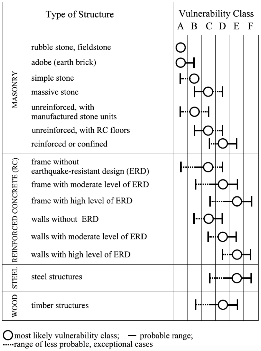
The new scale better considers spatial statistics of macroseismic effects and the low vulnerability of constructions built according to the recent earthquake-resistant building codes (Figure 1). Furthermore, EMS-98 becoming the standard in Europe, this macroseismic scale facilitates international exchange of macroseismic information across boundaries, as for the Rambervillers February 22, 2003 earthquake in the Northeast of France [magnitude 5.4, maximum intensity VI–VII; Cara et al. 2003, 2005].
Statistical table of damage grade by seismic vulnerability classes according to EMS-98.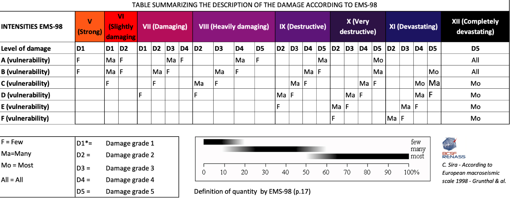
For each level of intensity, EMS-98 provides us a great deal of details in the expected behaviour of seismic indicators that can be observed and compared from place to place. Descriptions of building typologies and vulnerability classes have been detailed and expanded in this scale. Furthermore, the degrees of damage and the qualitative statements “few, many, most” are clearly defined, as summarized in Figure 2. Two full sections of the document describing the EMS-98 scale are dedicated to building vulnerability with examples. The EMS-98 is also commented with many remarks in order to help the experts in their analysis: use of negative information, uses of high buildings effects, warning on soil conditions, assessment of quality and uncertainties of intensities, and effects on the natural environment, which are mentioned but not taken into account for assessing intensity values. [EMS-98; Grünthal 1998].
3. Collecting and analysing macroseismic observations
Since the establishment of the first intensity scales, macroseismic observations have been processed according to similar procedures. Observations that are comparable from one place to another (human perceptions, objects, buildings, and the natural environment) are collected through questionnaires filled by territorial authorities or during expert field surveys. More recently, spontaneous witnesses filling up Internet questionnaires provides us many observations. Observed effects displayed by the media are also considered. In a second step, macroseismic intensities are determined on the basis of an analysis of these observations according to a macroseismic scale. At the end, cartographic representation of the intensities and drawing of isoseismic lines allow us to visualize the geographical distribution of the macroseismic intensities.
3.1. Collecting information questionnaires
3.1.1. Evolution of macroseismic questionnaires
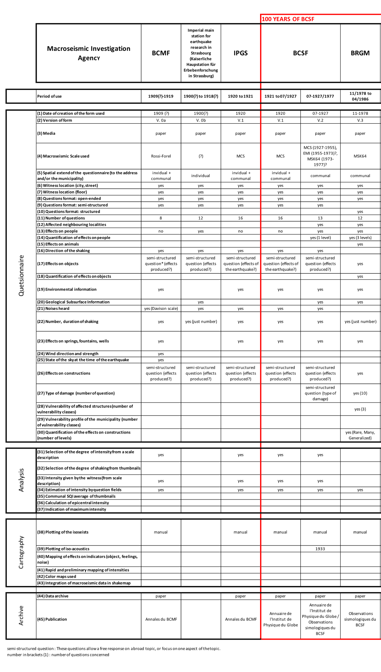
The structure of questionnaires has largely evolved since 1910 [Table 1, Sira et al. 2021a], from a semi-directive one (e.g., what effects did you notice?), to a list of standardized questions allowing the analyst to qualify and quantify an effect with maximum objectivity (e.g., qualification of the terms “low, medium, high” and quantification by “few, many, most”).
In the 1910 BCM questionnaire (Figure 3), the witness had to fix the Rossi–Forel intensity degree he experienced in his territorial unit by himself, according to a description of the scale given in the form. The questionnaire is presented in two parts, one for assessing intensity of the ground motion and the other one for the so-called “accidental noise” estimated with the Davison scale [Rothé 1934]. In 1914, the sound perception scale was removed from the form, but the more general issue of acoustic noise was kept.
1910 questionnaire of the Bureau central météorologique français based on the Rossi–Forel and Davison scales (BCSF archives).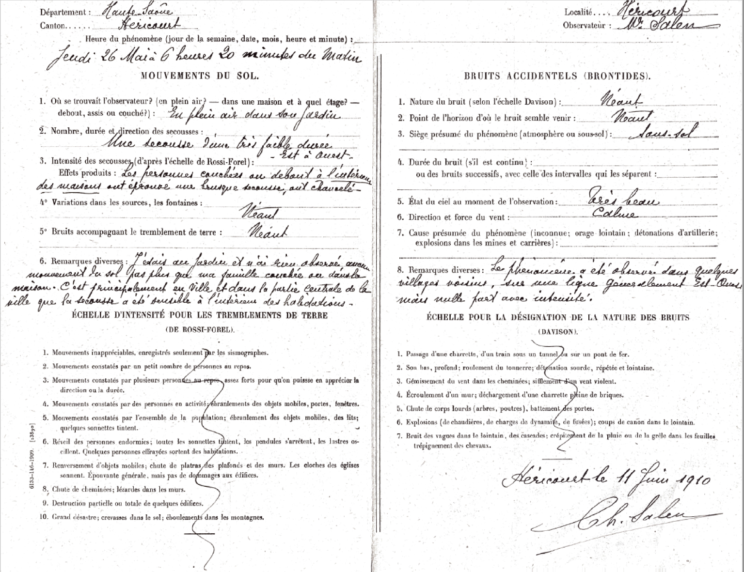
In 1920, the BCM questionnaire was changed (Figure 4). The Mercalli intensity with 12 degrees (Mercalli scale modified by Cancani in 1904 with 2 extra degrees at the top of the scale—according to the questionnaire in BCSF collection) can still be selected, but the witness is invited to answer additional questions, the BCSF adopted this form from 1921 to 1927.
1920 questionnaire based on the 12-degrees Mercalli scale (BCSF archives).
In 1928, BCSF created its own form with a denser questioning (Figure 5). However, the effects of several indicators (buildings, crockery, furniture, objects, or chimneys, etc.) are sometimes grouped together in a single question. The semi-directive questionnaire mentioned a single type of effect only (example: vibration of crockery). This leads to uncertainty and the impossibility of discretizing the effects according to different levels, as is done with a modern form (weak, medium, strong vibration, displacement, falling objects). The proportion of people who felt the earthquake, for example, is formulated in its simplest description: “did more than one person felt the earthquake in the locality?”
BCSF used this form until 1978 [Sira et al. 2021a], while the macroseismic scales in use (MCS, EMI, MSK-64) were evolving towards an increasingly fine gradation of effects and indicators. It is therefore likely that the 1928 questionnaire leads to an increasing uncertainty in the reported macroseismic intensity over time, until a questionnaire more adapted to the scale in use is introduced.
1928 questionnaire based on the 12-degrees Mercalli modified scale (BCSF archives).
In 1978, a new questionnaire based on the MSK-64 scale was designed by BRGM. The witness is no longer invited to determine the intensity by himself, but he must fill in a check boxes questionnaire. Questions are sorted according to observation types, and typical effects are given (vibration of dishes, falling objects, etc.). For the first time, the percentage of these effects (5%, 50%, 75%) is asked at the communal level. Damage to buildings by degree and frequency associated with the three MSK-64 vulnerability classes are requested. It is clear that this new scale, and the associated questionnaire have a major impact on the quality and accuracy on the estimated intensities. The intensity degree has then been determined by the expert analyst and no longer by the person answering the questionnaire [Schlich 1984].
Slight changes were made when BCSF took back the surveys in 1986. Acoustic noise, often mentioned by witnesses but absent in the MSK-64 scale, has been reintroduced. A revision of the questionnaire was made in 1995 with a few additional questions. This later change could have improved the quality of the information collected, but it made the questionnaire more difficult and longer to fill.
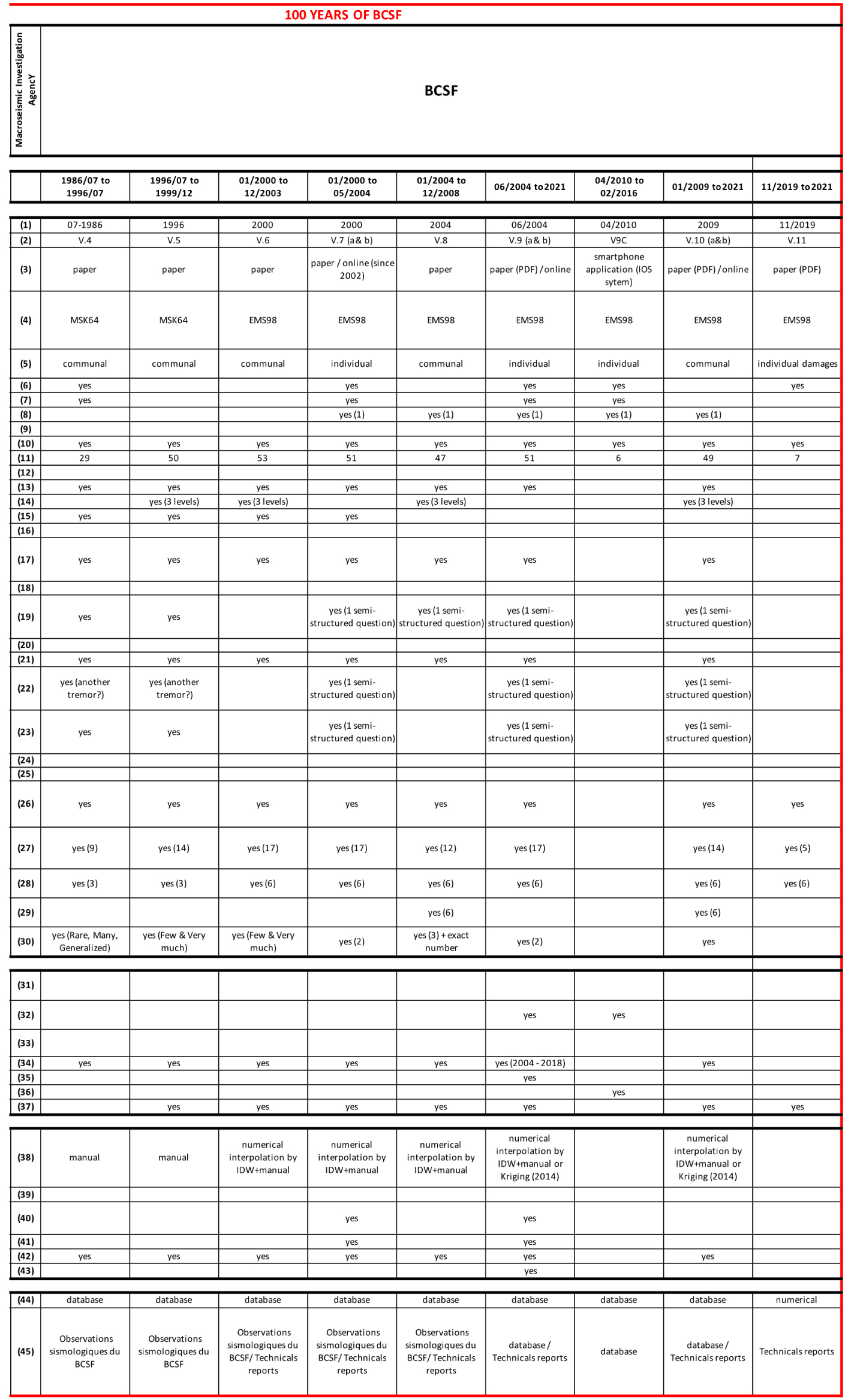
In 2000, BCSF adopted the EMS-98 scale. Two questionnaires were then designed, one dedicated to city agents asking for the effects observed over the whole commune, hereafter referred to “communal” questionnaire, and one dedicated to isolated witness, hereafter referred to “individual” questionnaire. Except for the number of classes of vulnerability of the constructions considered, the change in the list of questions between the MSK-64 and EMS-98 questionnaires remains marginal. Its layout was adapted to semi-automatic optical recognition.
In 2004, after experiencing the survey of the 2003 Rambervillers earthquake, the communal questionnaire was improved in order to better assess the percentages by type of structure (stone, concrete, wood, etc.), as well as the number of damages observed in each category. A version of the questionnaire adapted to the types of constructions of the West Indies was designed after the earthquake in Guadeloupe on November 21, 2004.
Extract from the first BCSF online internet questionnaire in 2001.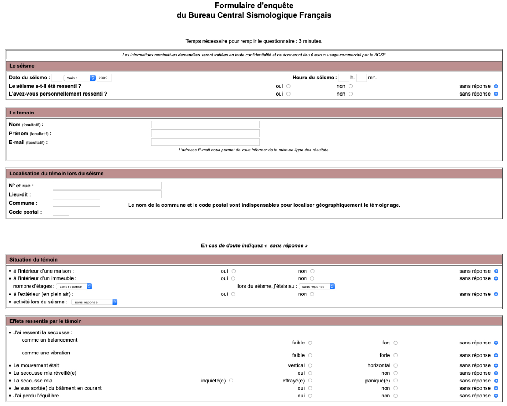
Extract of thumbnails to be selected in BCSF individual macroseismic questionnaire based on EMS-98 (inside building part).
In 2001, the first French online individual questionnaire “j’ai ressenti le séisme” was launched by BCSF (Figure 6). It was completed in 2004 by adding seven thumbnails describing the felt effects for the degrees II to VIII of EMS-98 (Figure 7). The idea was then to cross-check the coherency between answers to the questionnaire and the more global view coming from the selected thumbnails [Sira 2018]. This is, to our knowledge, the first time that such a strategy was implemented worldwide.
The most recent change in the communal questionnaire was made in 2009 in order to better describe the damage in buildings. Today, several information on residential building categories are accessible in public databases for French localities. Land declaration database, such as MAJIC II [Martin et al. 2008], allows us to estimate a vulnerability profile at the scale of a city or district [Schlupp et al. 2011]. Future versions of the questionnaire could be simplified and developed in a conditional questionnaire (some questions only appear when they become relevant) making the questionnaires shorter and more pertinent to the person filling out the questionnaire.
3.1.2. Collection of data with questionnaires
In France, systematic macroseismic investigation by a central service started at BCM after the Lambesc earthquake of June 11, 1909. Following this event, 4200 questionnaires were returned, filled in by the mayors and teachers of all concerned communes [Angot and Lemoine 1910; Fréchet 2008]. After 1921, Edmond Rothé, director of BCSF, pursued the way BCM organized the dissemination of questionnaires. For example, after the Rastatt, Germany, earthquake of February 8, 1933, among 1500 questionnaires sent, 1329 were returned, allowing BCSF to determine 530 intensity data point (IDP) [Rothé 1934]. IDP determines the geographical location, the name of the place (usually the commune), and the intensity value in a given macroseismic scale.
The local press, which is rich in reports of data corresponding with small intensities, may bear valuable additional information, but it is used by BCSF only in rare circumstances [Vogt 2003]. Calls for testimonials have sometimes been relayed in daily newspapers such as in “France Soir” when Professor Lemoine from the “Musée d’Histoire Naturelle” insert a macroseismic questionnaire after the Flanders earthquakes of June 1938 [Rothé 1941].
Summary table of macroseismic questionnaires from BCSF archives
 |
 |
In 1940, during the Second World War, BCSF moved to Clermont-Ferrand, South of the armistice line of demarcation. BCSF macroseismic investigations were made possible until 1950, thanks to the press media and the staff of the French meteorological stations [Rothé 1941, 1954]. Reports from the observers of meteorological stations remain an important source of information until 1961.
After the large earthquake in Arette of August 13, 1967 in the Pyrenees, 1191 questionnaires were sent back to BCSF (Figure 8) while, on its own initiative, the geography department of Pau launches an ad hoc macroseismic questionnaire and gathers more than 1500 answers from school teachers. Many such studies conducted by individuals, on their own initiative, were reported to BCSF. This is the case of the seismologist Pierre Stahl for the south west of France. If the observations collected induce some uncertainty in the estimated intensity, Pierre Stahl’s network of observers allows us to determine intensities for very low magnitude events, rarely surveyed by BCSF.
Evolution of macroseismic map, Arette earthquake 1967 [Rothé 1972], La Rochelle earthquake isoseists drawing by kriging interpolation [Sira et al. 2016a].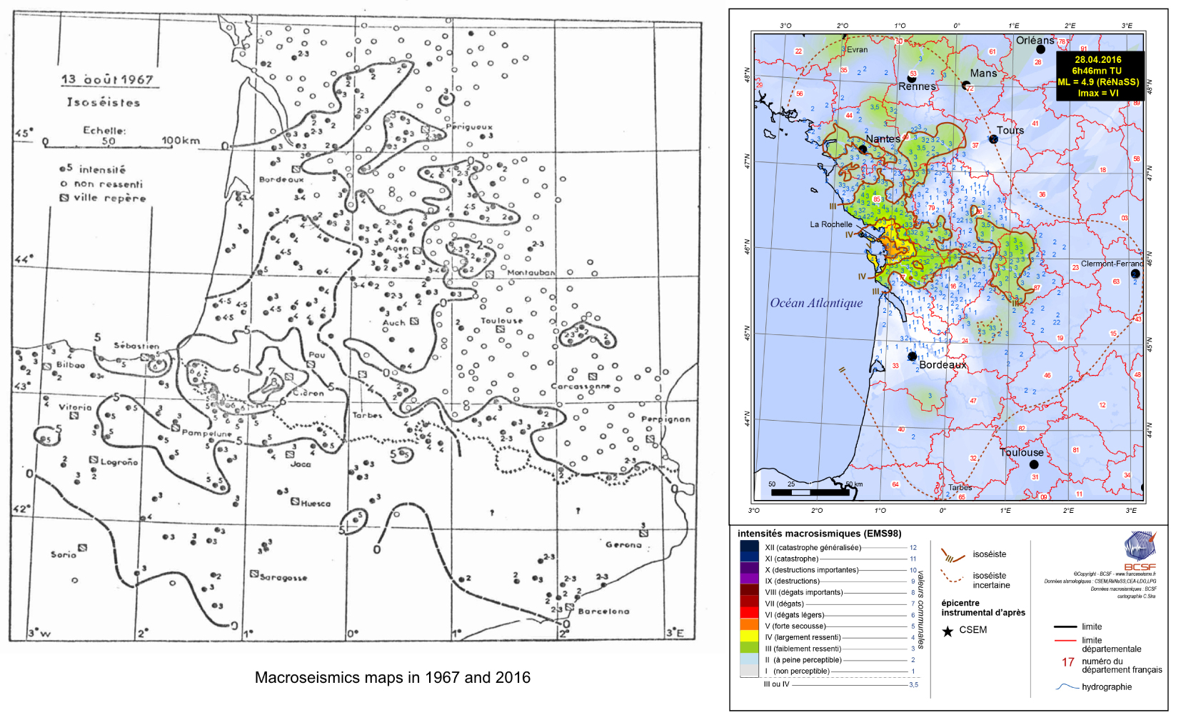
At the end of the 1970s, seismic alerts launched 24 hours a day by the geophysical laboratory of the French “Commissariat à l’Energie Atomique” (CEA), in close connection with the Civil Security authorities, became the main source of information for starting macroseismic investigations, in particular for low-magnitude events, solely locally felt. The more or less lack of interest in macroseismic surveys by academic organizations, the need to better take into account seismic hazard in the growing French nuclear plant programme, and the retirement of Jean-Pierre Rothé in 1975, motivated BRGM to take over the conduct of the surveys in 1978. “BRGM has recreated a network of correspondents with the Civil Security authorities. Public awareness and support of the regional press have greatly facilitated the work of the investigators” according to Vogt [2003].
After 1980, the development of the academic instrumental network “Réseau national de surveillance sismique—Rénass” with headquarters located next to BCSF in Strasbourg became the new actor complementing the CEA network for launching macroseismic investigations. After nine years of macroseismic investigation based on the MSK-64 scale, BRGM reduced its involvement in this field and the management of the surveys came back to BCSF pursuing the survey model used by BRGM.
Cross-border macroseismic intensity map of the Rambervillers earthquake, February 2003, ML 5.4 [Cara et al. 2003].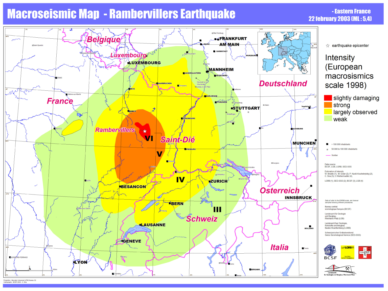
Until 2000, the distribution of communal paper questionnaires, with the help of the regional authorities, was the rule. After having tested several types of distribution networks, it became obvious that the development of the Internet could deeply change the way to collect macroseismic information. The first opportunity for BCSF to test such an Internet procedure was the 2003 Rambervillers earthquake [Cara et al. 2003]. BCSF collected nearly 13,000 individual Internet testimonies and 7376 communal questionnaires. Thanks to the new Internet media, 6154 IDP have then been obtained at distances up to about 650 km away from the epicentre (Figure 9).
In early 2009, the communal paper questionnaire procedure was replaced by an Internet communal questionnaire dedicated to local authorities through restricted access. The answers are then directly integrated into a database for analysis. This reduced the delay time for launching macroseismic investigation to less than 48 hours after the earthquake. In February 2010, BCSF launched the first smartphone application SismoCom in order to collect individual testimonies based on a selection of thumbnail images (Figure 7) [Sira et al. 2010]. Stopped in 2016, this application will be replaced by an adaptive multi-platform system.
In the French West Indies, since Les Saintes Earthquake in 2004 [Cara et al. 2005], the “Observatoire sismologique et volcanologique de Guadeloupe” and the “Observatoire sismologique et volcanologique de Martinique” of “Institut de Physique du Globe de Paris” systematically relays the calls for individual testimonies, as well as for communal surveys requested by the governmental regional authorities.
In Mayotte, Indian Ocean, REVOSIMA (Réseau de surveillance volcanologique et sismologique de Mayotte), created after the volcano-seismic crisis that started in June 2018, now helps to relay the calls for individual testimonies. BCSF was set up in 2020 with a group of correspondents with the Mahoran authorities in order to respond online to communal questionnaires after significant earthquakes.
Since 2000, in order to increase the number of individual testimonies for each macroseismic survey, a BCSF press release is sent directly to the regional and/or national media. It was replaced in 2014 by an automatic seismological information mailing list. In 2009, two social pages were created on Twitter (@franceseisme, 4955 followers in 2020) and Facebook (@franceseisme, 4460 subscribers) for the same purpose. Today, BCSF launches around twenty macroseismic surveys per year in metropolitan France and the overseas territories.
3.1.3. Collection of data by field survey
Field survey conducted by experts is the only way to reliably estimate macroseismic intensities in localities, where the level of shaking causes damage on the most vulnerable constructions (I ⩾ V). Indeed, the vulnerability of buildings and the frequency of damage are then key information for a correct evaluation of intensity. During the XXth century, macroseismic field surveys have been very limited in France. Among noticeable exceptions, let us mention commandant Spiess’ survey. As a military officer and member of the French Geological Society, he reported damage assessment after the 1909 Provence earthquake with rigour and accurate details [Lambert 1997], and Rothé and Vitart [1969] reported their survey of the 1967 Arette earthquake in the Pyrenees with description of the damage in relation to the building vulnerability.
A first inter-agency collaboration in the field was launched in 2003, after the Rambervillers earthquake. Four scientists were involved [Cara et al. 2003] for estimating 35 communal intensities. In 2004, the November 21th Saintes earthquake in Guadeloupe, French West Indies, (magnitude 6.4, maximal intensity VII–VIII EMS-98) was the occasion of renewing this collaboration in the field. It made it possible to estimate 32 communal intensities [Cara et al. 2005]. In 2007, 11 scientists took part in the macroseismic study in Martinique after the November 29th earthquake (magnitude 7.4, Imax VI–VII EMS-98) and 34 communal intensities were determined [Schlupp et al. 2008]. The necessity for launching a field survey above intensities V motivated BCSF to create the French macroseismic intervention group (Groupe d’intervention macrosismique (GIM)) in 2011 [Sira 2015].
In 2011, in connection with the GIM, BCSF brought together 18 new members for a first training session dedicated to field investigations, in particular for vulnerability and damage degree assessment according to EMS-98 scale. Specific documents for estimating the degree of vulnerability and damage have been prepared and are regularly improved after each field surveys. To date, BCSF has organized 8 training sessions for more than 80 experts from France and neighbouring countries ready to participate in macroseismic field surveys.
The GIM was activated after the 2014 Barcelonnette earthquake in the Alps, [Sira et al. 2014], the 2016 La Rochelle earthquake on the west coast of metropolitan France [Sira et al. 2016a], the volcanic crisis in Mayotte [Sira et al. 2018] and the November 11, 2019 Le Teil earthquake in the Rhone valley (Imax = VII–VIII) [Schlupp et al. 2021]. The GIM field surveys have to take place in the days following the earthquake, after the rescue of the victims and before, when possible, a series of aftershocks which could make it difficult assessing the intensities of the main shock. Based on his experience with the GIM, BCSF participates in a joint effort to set up a cross-border macroseismic group trained with experts from France, Spain, and Andorra (GIM-PYR) dedicated to field survey of potential damaging earthquakes in the Pyrenees (POCRISC.eu, For a Common Culture of Seismic Risk).
3.2. Analysis of macroseismic information
Little information is available on the analytical methods used at BCSF for estimating intensities, other than to rely on descriptions of macroseismic scales. Unfortunately, the scale used is not systematically indicated on published macroseismic assessments, and only the search for clues in publications or on the questionnaires themselves can confirm this with more or less certainty. Although some variations in the interpretation of questionnaires occur from one expert to another with the same scale; the most recent scales reduce this difference and open up the reinterpretation of past questionnaires once a clear and shared decision strategy has been decided upon.
The 1928 questionnaire, used by BCSF until 1978, invites the witnesses to give some various information, including their own assessment of macroseismic intensity. In the light of this questionnaire, it is clear that in case of building damage, little attention is paid to the vulnerability classes and the frequency of damage. Without information coming from additional sources, reassessing intensities from the questionnaires is almost impossible according to modern standards. Except in a few cases, the reassessed intensity values should thus present a large uncertainty. Such an exception is the February 10, 1937 earthquake in Algeria (Imax = IX), for which a particular attention was, for example, paid to the description of damage [Rothé 1940].
Another issue that often arose from the use of the ancient scales is the presence of intermediate value between two intensity values. These intermediate values (e.g., V–VI) do not necessarily represent the same information and unfortunately, no information is given in the publication about the exact significance of these intermediate values. Sometimes they express uncertainty in the intensity values, sometimes they result from the average of communal values over a larger territorial unit such as the “canton” as it is the case for the earthquake of the June 11, 1938, in Belgium [Rothé 1941]. Half values of intensity may also reflect the presence of two distinct values within the site under study, as it is sometimes the case for intensity determined during more precise field surveys since 2000 [Les Saintes earthquake, 2004; Barcelonnette earthquake 2014; Le Teil earthquake, 2019 [Schlupp et al. 2021]].
Vogt [2003] pointed out that in the past, many of the BCSF intensity estimates are questionable. To the credit of the analysts in charge of the intensity determinations at BCSF, the shortcomings in the qualification and quantification of the effects in the 1928 BCSF questionnaire could only leave a large part of subjectivity in the evaluation or re-evaluation of intensities. This is only since 1978 that the BRGM questionnaire became formatted as a series of questions, facilitating the determination of intensity by experts. The fact that different macroseismic scales are referred to in BCSF data base (12-degrees Mercalli, MSK-64, and now EMS-98) is an additional difficulty for assessing homogeneous macroseismic intensities in earthquake catalogues. In order to circumvent these difficulties, the historical database SisFrance uses a unique macroseismic scale (MSK-64) when reassessing the different intensities, while BCSF keeps the original values in its database, leaving the user making the choice of conversion table to interpret the different values.
For the February 29th, 1980 Arudy earthquake in the Pyrenees, the building damage degrees and vulnerabilities have been reported and considered according to MSK-64. However, even in this case, the vulnerability information remains too poor for determining the proportion of damages per class of vulnerability for both MSK-64 and EMS-98 intensity estimations. Since 2000 and the use of EMS-98, the analysis of the building information is improved. The knowledge of the vulnerability classes at the communal level [Schlupp et al. 2011] helps us to better estimate the frequency of damage degree by class of vulnerability and then greatly improves the quality of the intensity value as representative of the ground shaking.
Since 2000, communal intensities are determined at BCSF following two main methods. First, within a commune, a preliminary intensity is rapidly estimated from individual testimonies and the thumbnails selected by witnesses. In the case of a few observation points, no statistic on indicators effects can be done within the commune, and the selected thumbnails method just provides us a Single Questionnaire Intensity (SQI) for each geolocated individual testimonies (city, street, or exact address). Testimonies at floors above the 4th or underground are excluded, and SQI at 3rd and 4th floors are reduced by 1 degree. The automatic average of SQIs per municipality gives us a preliminary intensity for rapid information [Sira et al. 2016b]. From 2004 to 2016, 35,000 questionnaires were analysed by hand in order to compare the individual intensities so obtained with the values of individual intensity coming from the selected thumbnails [Sira et al. 2013]. In these preliminary intensities, an underestimation of epicentral intensities higher than V was noted, mainly due to the absence of testimonies from people who were heavily affected by the damage and were mainly busy solving accommodation, insurance, and security problems [Sira et al. 2021a,b; Schlupp et al. 2021].
Damage comparison tool with EMS-98 descriptions by intensity levels, e.g., by average statistics approach (the statistical reference level (base of calculation) can be changed in this comparison file).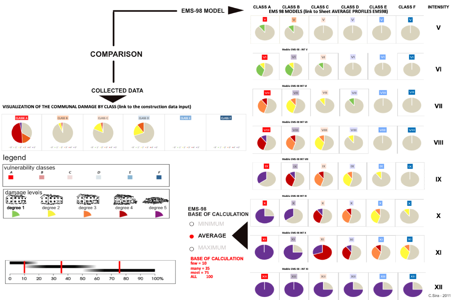
Second, the communal reference intensity is determined from the answers to the EMS-98 communal questionnaires. If there are more than 10 SQIs collected in the same commune, the answers to individual questionnaires are also considered in the analysis. In the case of an earthquake generating damage to buildings, the GIM group carries out in the field an assessment of degree of damage (5 levels) for each vulnerability class (6 classes) and their frequency in each commune. These results are then compared with the statistical levels expected in the EMS-98 scale for each intensity (Figure 10) in order to determine the definitive intensity. Additional data provided by the communal authorities can complete the set of documents used in this evaluation. Let us note that the statistical representation of the macroseismic observations collected by the authorities can be affected by some biases, but the definition in EMS-98 of the quantity within three levels (few, many, at most) limits its impacts on the quality of the intensity estimation and at the end, the GIM estimates are predominant over all other analyses.
3.3. Mapping representation
Macroseismic intensities of the most significant earthquakes are presented on isoseist maps since the Neopolitan earthquake in 1857 [Oliveira 2021]. These types of maps have undergone a strong evolution due to the plotting method as well as ways of representing the intensities (Figure 8). In addition to intensities, local directionality or site effects correlated with the geology are sometimes shown on the map [Rothé 1941]. BCSF published the first map of isoseists for three earthquakes in the Pyrenees in 1922 [Rothé 1923]. In the past, many isoseismal maps were described in BCSF reports but were not printed [Rothé 1924]; the high cost of reproducing such maps in publications prevented their publication [Rothé 1924]. With a few exceptions, mainly tables of intensity were reported until 1935. BCSF archive contains many unpublished manual drawings of intensity maps. The number of macroseismic maps increased rapidly when Jean-Pierre Rothé became director of BCSF [Rothé 1954].
Preliminary internet intensity map (www.franceseisme.fr, 2012), Saint-Pé-de-Bigorre (Pyrénées) earthquake (31/12/2012, ML: 4.9).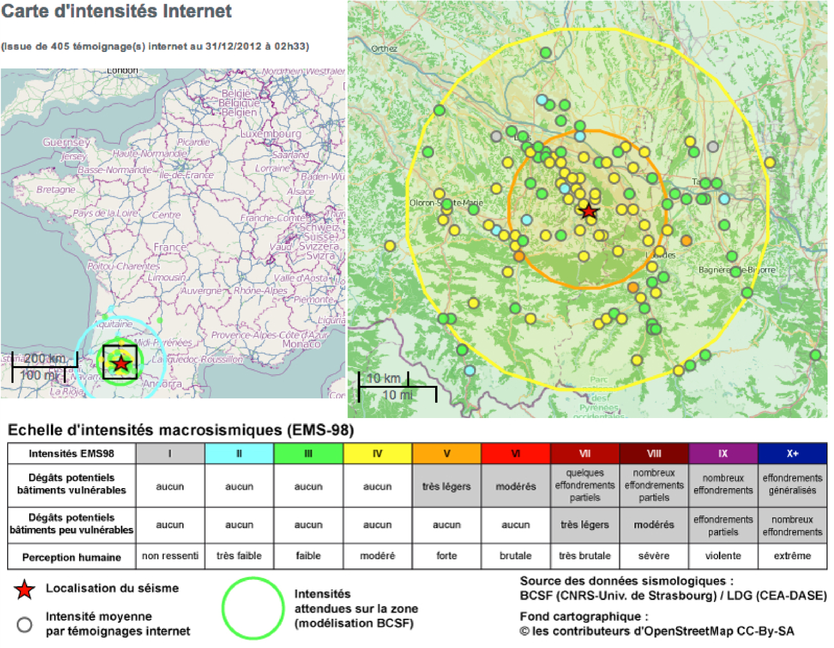
Map of the effects on witnesses (most frequent value in the commune, all floors of the witness): panic (in red), fear (in yellow), anxiety (in green), without anxiety (in grey). Le Teil earthquake 2019 (ML 5.2).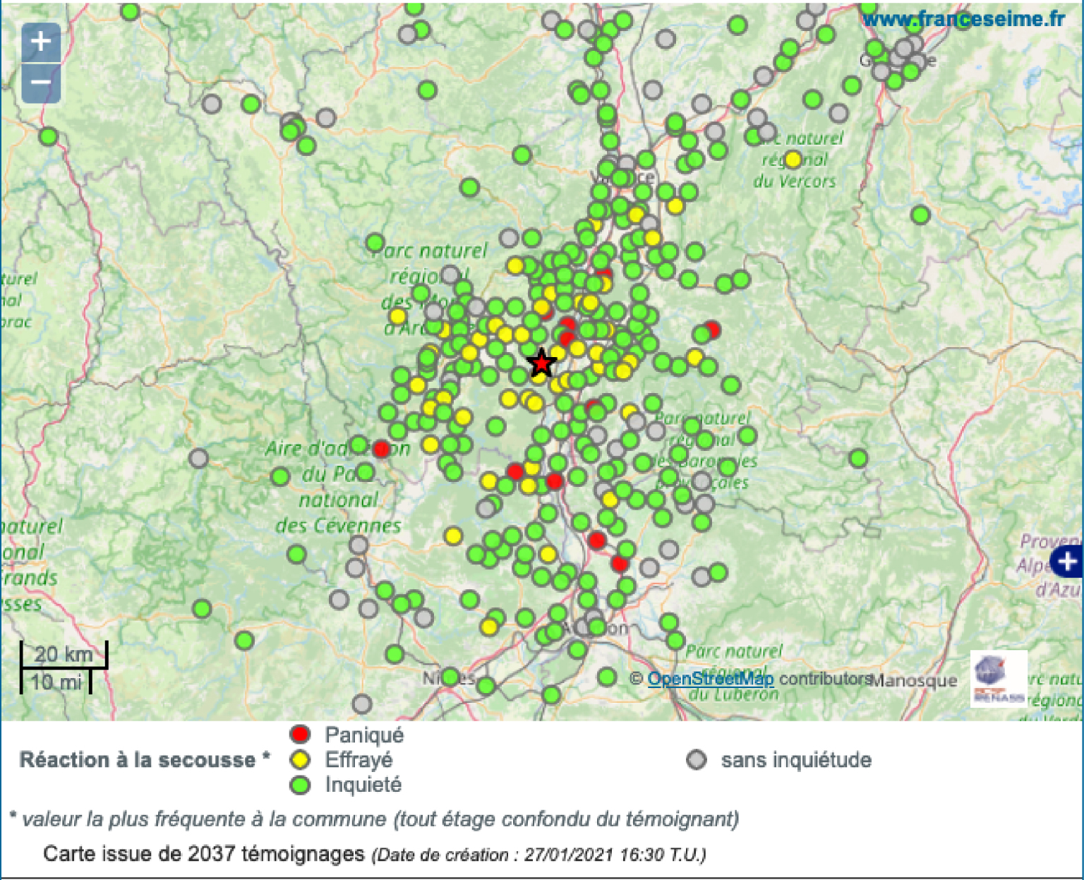
The colour maps, together with the first numerical drawing of isoseists were produced for the 1989 events [Schlich and Hoang Trong 1994], while previously, they were drawn by hand by an expert. In 2000, the Geographic Information System (GIS) allowed to perform a computer interpolation of intensity points and then semi-automatic isoseismic lines. The spatial distribution of intensities is based on colour ranges overlaid on topographic maps. Until 2012, the interpolation was based on a deterministic Inverse Distance Weighting (IDW) approach and since 2016 on kriging (Figure 8). Since 2012, an automatic rapid mapping of preliminary communal intensities (Figure 11) is implemented on the BCSF-Rénass website (www.franceseisme.fr) based on the average SQI of individual testimonies, as well as maps of some others indicators of seismic effects (Figure 12): noise, falling objects, and witness perception. This mapping is automatically updated as soon as new information are received.
Because many earthquakes in Europe are located near the country borders, merging coherent macroseismic information in cross-border maps is also an important issue (e.g., Figure 9 for the Rambervillers earthquake). After the recent work of Van Noten et al. [2017] aimed at merging the cross-border intensities data of the 2011 ML 4.3 Goch earthquake (SE UK), and the 2015 ML 4.2 Ramsgate (Germany), an European mapping project merging individual Internet testimonies is being developed by the Macroseismic working group of the European Seismological Commission.
3.4. Storage and dissemination of information
Since 1921, BCSF archives have been mainly managed by the “Institut de Physique du Globe de Strasbourg” (now by EOST) within the Faculty of Sciences of the French University of Strasbourg. When BCSF moved to Clermont-Ferrand during the Second World War, some documents may have been lost but many original works have been preserved. BCSF archives include data on all earthquakes studied and felt in metropolitan France and overseas since 1919. Macroseismic survey documents from 1919 to 2012 are kept in a dedicated room in archival boxes on about 40 linear metres [Schirr 2011]. Unfortunately, fungi affect some of the oldest boxes and other documents have suffered from mechanical damage. To safeguard this content of scientific value, the digitization of 70,000 selected documents, out of about 350,000, started in 2020 with the strongest earthquake documents. They contain individual data subject to the GDPR (https://ec.europa.eu/info/law/law-topic/data-protection/data-protection-eu_en), but they should be progressively accessible online for scientists from 2022.
In 2000, BCSF developed a macroseismic database called “Epicentre” for the storage of information allowing the mapping of results with a GIS. The macroseismic questionnaires from 1996 to 2012 are stored in digital format, as well as all the estimated intensities in the different macroseismic scales since 1920. After 2012, the online questionnaires, individual and communal, have been integrated into the database.
To date, BCSF database contains more than 121,000 communal intensity data points (IPD) starting in 1921 for nearly 2000 recorded events. Since 1996, more than 181,000 questionnaires have been recorded in the database (Figures 13, 14, 15). Today, definitive IDP starting from 1996 are included in a Contemporary Macroseismic Database which are freely accessible online (http://www.franceseisme.fr//donnees/BD-MFC/). A new database is being developed with all IDP and connection between the macroseismic and instrumental data. The SisFrance historical intensities (BRGM—Electricité de France—Institut de radioprotection et de sûreté nucléaire) will also be associated with the intensities of BCSF-Rénass.
Location of macroseismic surveys in BCSF-Rénass macroseismic database.
Number of intensity data points in BCSF-Rénass macroseismic database.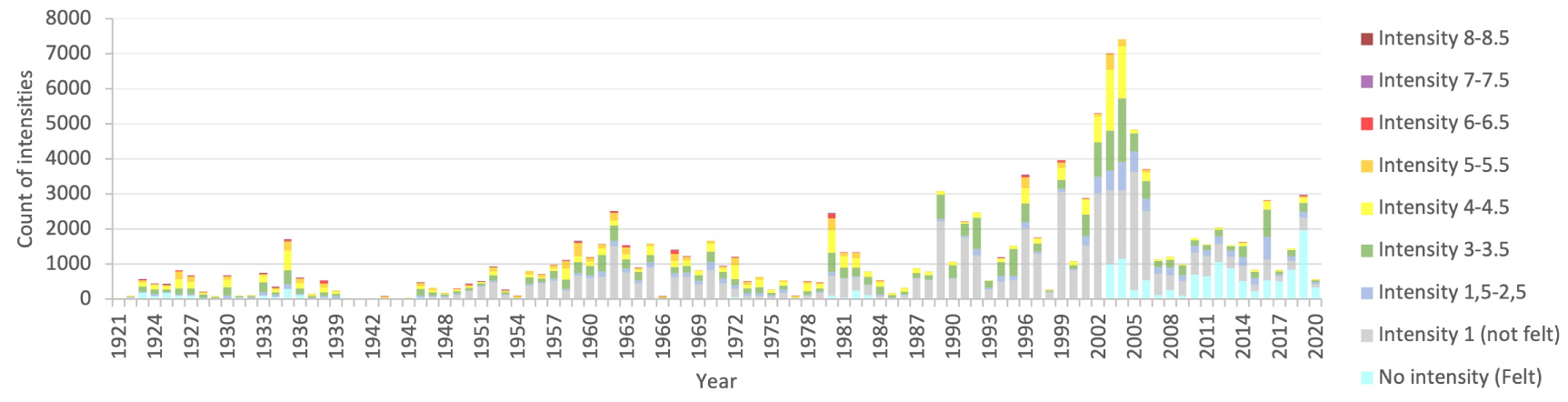
Number of macroseismic surveys in BCSF-Rénass macroseismic database.
Sixty macroseismic reports, illustrated with numerous maps, have been published on www.franceseisme.fr for the most important French earthquakes since 1989.
4. Use of the French macroseismic data
Despite the development of permanent seismic networks, except when dense local networks are present, as in the Alps and the Pyrenees, macroseismic data remain the only, or if not the most relevant data, in the first kilometres around the epicentres. The nearly 35,000 French municipalities indeed form a much denser network than the about 400 sites equipped with seismic sensors. The only limitation is the presence of observers in the affected area who can report macroseismic observations or macroseismic indicators affected by the shaking (objects, buildings). Far from drying up, as might have been thought at the end of the 20th century, the volume of macroseismic data collected is still increasing rapidly. Those interested in earthquakes and seismic risk frequently consult data that are disseminated and published by BCSF-Rénass like preliminary maps produced quickly, finalized reference maps, or various analyses.
The use of macroseismic data and intensities is constantly increasing and their dissemination is largely facilitated by the implementation of databases and Application Programming Interface (API) at BCSF-Rénass. The main purposes are: behaviour of the observed indicators (people, objects, furniture, constructions), severity of the tremor, estimation of the affected zone, calibration of source and attenuation parameters in relation to instrumental data, ground motion modelling, site effects, risk management, scenario simulation, seismic hazard assessment; so many fields in which macroseismic data are today indispensables.
4.1. Earthquake parameters
At the territorial level, instrumental catalogues, mainly for events after the 1960s [Cara et al. 2015], display accurate epicentre locations, but in some cases, even today, earthquake locations remain poorly constrained (poor azimuthal distribution of stations, absence of stations close to the epicentre, simplified velocity model), and in most cases the focal depth is poorly determined. In these cases, without a surface break on a fault (e.g., the Teil earthquake of November 11, 2019 [Cornou et al. 2021]), accuracy of the instrumental location may be larger than 10 to 20 km. Sometimes, macroseismic data reveal major inconsistencies between the zones of highest intensity and the location of the instrumental epicentre that would otherwise have gone unnoticed. Going back to the first half of the 20th century or even earlier, these data become essential, if not the only ones, for determining a “macroseismic epicentre” and the magnitude/depth of the earthquake in France [Cecić 1996; Scotti et al. 2004; Musson and Cecić 2012; Manchuel et al. 2018]. In the absence of a seismological station in the epicentral zone, the focal depth of small earthquakes can be apprehended by the pattern of macroseismic intensities around the epicentre [Traversa et al. 2018].
Many estimates of magnitude have solely been determined with the epicentral intensity parameter on epicentral intensity in the past. Indeed, the earthquake magnitude can be linearly related to the epicentral intensity because up to 1.25 Hz (corner frequency of the Wood Anderson seismograph with which the Richter magnitude has been originally defined) of the output signal is proportional to the ground acceleration [e.g. Aki and Richards 1980]. Peak acceleration can thus be considered as proportional to intensity (see GMICE section below). However, the intensity at the epicentre, I0 is often derived by interpolation from surrounding observations. It is also sensitive to site effects and the depth of the hypocentre. For this reason, I0 is by far not the best parameter for assessing magnitude of historical or contemporary earthquake, but it is often the only one when there are few observations available. Other parameters, such as the radius of iso-intensity lines, are more robust when available [Frankel 1994; Cara et al. 2008]. Depending on the available data, Traversa et al. [2018] selected different methods for estimating the moment magnitudes Mw of past earthquakes that were used for the seismicity catalogue FCAT-17 of metropolitan France [Manchuel et al. 2018].
4.2. Regional attenuation laws
Concerning attenuation properties, macroseismic data have made possible the identification of strong differences between regions of metropolitan France [BakunScotti 2006; Baumont et al. 2018] which were not clearly quantified in instrumental data because, until recently [Mayor et al. 2018], instruments were concentrated in border regions of the Alps, the Rhine graben and the Pyrenees. These results on various attenuation characteristics are, for example, confirmed by the macroseismic and instrumental observations of recent earthquakes of magnitude >4 located in western France [Sira et al. 2016a; Sira and Schaming 2018; Sira et al. 2019].
In 2004, after the Saintes earthquake in Guadeloupe [Cara et al. 2005—Imax VIII in the commune of Terre-de-Haut], Beauducel et al. [2011] set up a simple attenuation model for French West Indies based on instrumental data with 13 accelerometric stations (magnitude, hypocentral distance, and peak ground acceleration (PGA)). On the basis of PGA-intensity relationships, they set up for the first time in France semi-automatic information specifying the probable intensities just after the occurrence of an earthquake.
4.3. Intensities versus instrumental ground motion parameters
For a wider use of the numerous macroseismic data, by coupling them with instrumental data, it is necessary to establish conversion laws between instrumental and macroseismic observations (GMICE). As early as 1904, Cancani indicates a factor of 2 in the PGA difference between two degrees of intensity. Many relationships published since then are the subject of numerous comparisons [Caprio et al. 2015]. The most frequently used conversions are with PGA, but Lesueur et al. [2013] show a better correlation between intensities and peak ground velocity (PGV). On the other hand, Atkinson and Sonley [2000] from California data and Souriau [2006] from French data identify a dependence with the epicentral distance for the PGA—Intensity relationship due to the modification of the frequency content, and thus a frequency dependence of the regional attenuation characteristics. The recent study of Mayor et al. [2018] shows that considering a realistic 2-D distribution of absorption will improve the macroseismic intensity attenuation models.
4.4. Site effects
Site effects are included in macroseismic observations and the intensities determined according to modern macroseismic scales. Hence various attempts are made to identify them. They first need to identify the intensities not “at the rock” and those potentially affected by topographic site effects. This can be envisaged when there is precise geolocation of individual testimonies allowing cross-checking with large-scale (at least 1/50,000) local geological or topographical data. But this becomes a challenge with communal data, mostly located in both rocky and sedimentary areas, in varying proportions [Cara et al. 2007]. This is a clear limitation in site effects studies that cross-cut communal intensities, which are located at the official commune coordinate single point, with geological maps. The results from studies using small-scale geological data, as in Bossu et al. [2000] based on 1/1000,000 scale geological map, should be considered irrelevant. However, these local effects are sometimes visible during post-seismic macroseismic field studies (GIM) with variability between sediment and rock zones within the same commune. They are currently represented at BCSF-Rénass by double intensity levels for the same commune (e.g., V–VI or VI–VII). This double value can mean an uncertainty between two intensity values or for estimates from precise field observations, one or the other value is present in the municipality (this can indicate local site effects). Despite the EMS-98 rule to indicate the lower value, the BCSF has chosen to keep the indication of the double values to allow a better link with the estimates using past scales (MSK-64 in particular). While it is easy to convert half values to lower values, the reverse is not.
4.5. Seismic hazard investigations and seismic zonation
Seismic hazard investigations strongly rely on seismicity catalogues that must be as complete as possible and should cover as long time as possible. For metropolitan France, Rothé [1967] took up the macro- and microseismic data covering the period 1021–1960 in a first attempt to create a seismotectonic map. The Perrey catalogues [e.g., Perrey 1845] as well as 1650 documents of BCSF archives were incorporated in his study. For each earthquake, the maximum intensity is indicated and is associated with a known geological accident. The double chronological and geographical file issued from Rothé’s work became the main source of information for the first French seismic code (rules PS-64). Today, probabilistic and deterministic seismic hazard studies still strongly rely on macroseismic intensities. The most recently published seismicity catalogue based on macroseismic and instrumental data is the FCAT-17 catalogue [Manchuel et al. 2018], and the comparison between the macroseismic intensities of metropolitan France with a European probabilistic seismic hazard model has been made by Rey et al. [2018]. The intensities are, for instance, used in the deterministic approach [Scotti et al. 2014] for nuclear facilities safety rules [ASN 2001, RFS-2001-01] and for the hazard studies to produce the regulatory seismic zone map (last French decree in 2010).
4.6. Shakemaps based on macroseismic and instrumental data
The first rapid shakemap calculations were initiated by the TriNet project [Wald et al. 1997], thanks to the very rapid availability of instrumental data in California, mainly for crisis management purposes. The USGS quickly distributed a “ShakeMap” programme for operational computation [Wald et al. 2005] that is used worldwide. The macroseismic intensities derived from the “USGS-Did You Feel It” online form quickly appeared to be relevant [Atkinson and Wald 2007] and led the USGS to develop version 3.5 of the ShakeMap programme. This version was implemented in France since 2012 [Masson et al. 2021]. Macroseismic intensities collected in France from Internet testimonials on www.franceseisme.fr are integrated and shared with the scientific community via an API from the first minutes after the event. They provide major spatial information, particularly in the first 50 km, with a ratio of up to a hundred between the number of communal intensities and instrumental measurements. As soon as earthquakes occur and for crisis management, the shakemaps deduced in particular from the preliminary intensities make it possible to rapidly model damage if one has knowledge of the vulnerability of buildings in the affected zones [Guérin-Marthe et al. 2021]. Beyond crisis management, the final intensities derived from the communal questionnaires and the field mission can be used to produce a reference shakemap for the event.
4.7. Intensities and official recognition of natural disaster
In case of major damage, BCSF-Rénass is officially in charge of determining the communal macroseismic intensities in the area affected by damages within a short period of time and to transmit them to the Department of Civil Defence and Emergency Preparedness. This department is in charge of the natural disaster classification for insurance involvement in France. Through this procedure, BCSF-Rénass has been the reference player for 33 years. The work is mostly based on field investigations for the precise estimation of degree of damage to buildings by vulnerability classes EMS-98.
4.8. Seismic risk studies
Macroseismic intensities, linking building vulnerability and damage through a simplified three-level statistical approach [few, many, most Grünthal 1998] are used to predict damage, notably via the Risk-EU conversion matrices [Milutinovic and Trendafiloski 2003]. Thus, within the framework of crisis preparedness or seismic risk awareness, the impact of the intensities of some historical earthquakes in France can be used to simulate the level of damages and cost in the current urban areas by considering the evolution of vulnerabilities [Lambesc earthquake 1909, Riedel et al. 2014].
4.9. Media information, public awareness, and education
Macroseismic data have been available online for nearly 20 years, enabling effective participatory science to be engaged in a win–win relationship. Internet users inform the scientists who return to them, via the website or the media, the results of the analysed testimonies. Nearly 116,000 testimonies from citizens, including 15,000 from overseas departments, have been collected since 2000. Visits to the website www.franceseisme and the social networks pages by the public show their interest for a better knowledge of telluric phenomena. Better understood, the seismic risk is thus better considered by the citizens and elected officials who are better able to measure the importance of respecting appropriate behaviours and seismic building regulations.
5. Perspectives and evolutions
Macroseismic studies experienced less and less scientific interest in the second half of the 20th century, when earthquake phenomenon became more and more understood, thanks to instrumental development, in particular with the accelerometric networks. However, since 1970, more quantitative information can be gathered from macroseismic data, first due to the improvement of intensity scales, with MSK-64 and then EMS-98, and second with the use of other indicators of the ground motion, such as “vibratory motion” felt by witnesses or “displacement and falling object”, which are clearly frequency-dependent sensors [Lesueur et al. 2013]. Although there is still room for improvement in the description of seismic effects according to intensity levels, in relation to the magnitude and distance from the epicentre, considerable progress has been made at BCSF since the time when a first seismicity map of France was presented by Jean-Pierre Rothé in 1937 (Figure 16). A comparison with the map of maximum intensities covering the period 1920–2020 in metropolitan France (Figure 17) illustrates the progresses made in both the number and quality of macroseismic data.
Map of the distribution and extension of earthquakes in France. The different colours do not have any special meanings and are intended to make it possible to distinguish the areas of the extensions of the main earthquakes for the years 1925–1936. [Rothé 1937] (with gracious authorization of Hatier edition).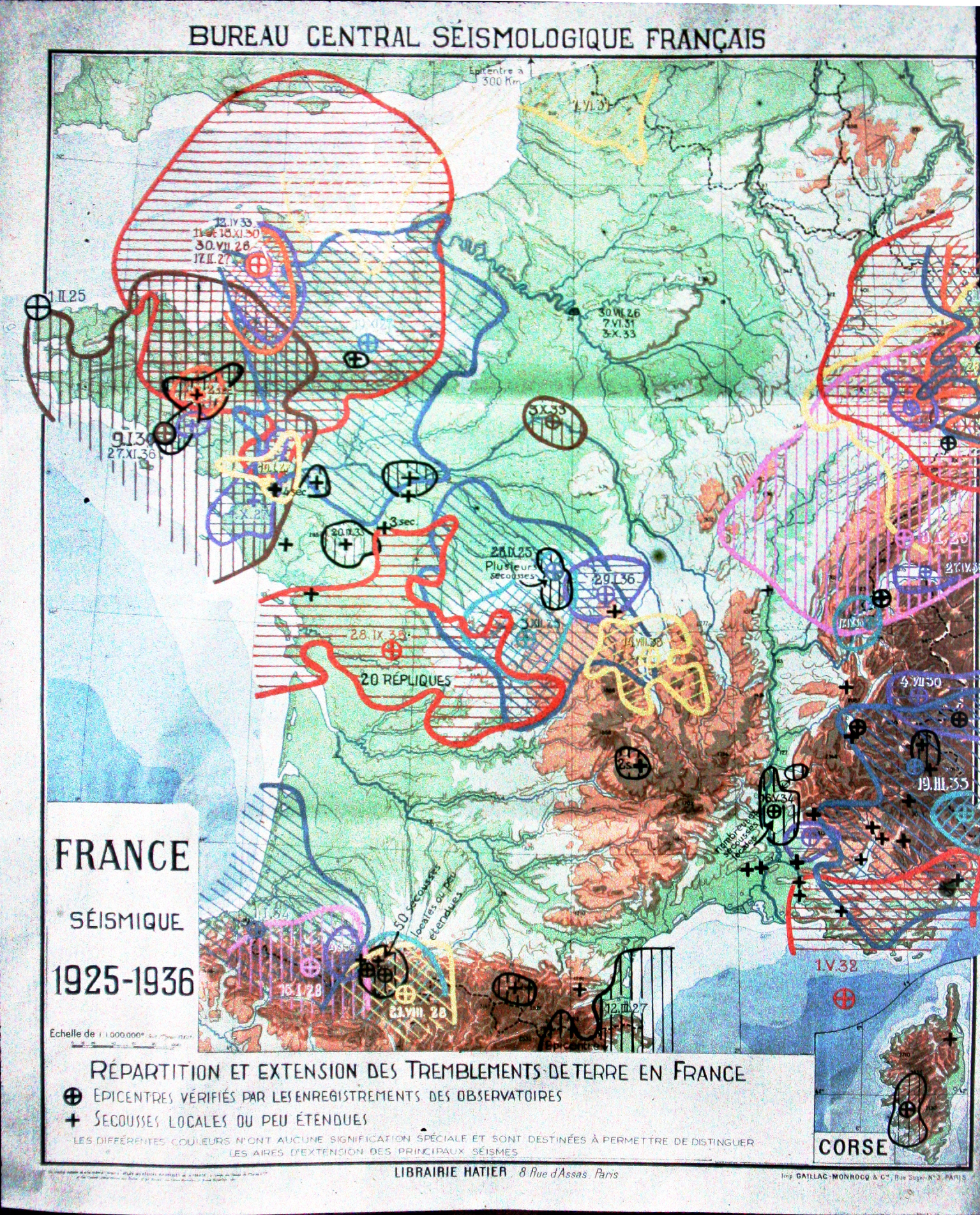
Maximum communal intensities from 1920 to 2020 (BCSF-Rénass database-December 2020).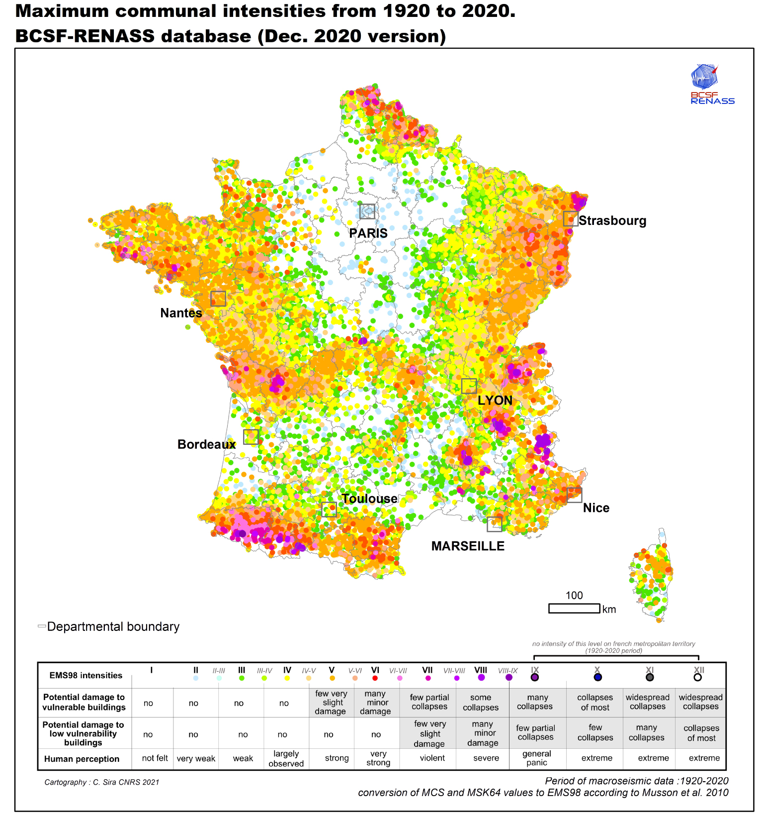
Given new methods of information collection (individual and communal internet questionnaires, social networks, field expertise) and analysis (data mining algorithms on testimonies or press articles), the amount of accessible information becomes an important resource for updating intensity scales and for supplementing the necessarily scattered information from the accelerometric networks.
Information collection can be improved and several challenges remain to be addressed. A balance needs to be found between the classical questionnaires (individual or communal) that are very informative but time-consuming to fill in, and simplified questionnaires less reliable and informative, that can cover the affected area with more numerous data points but reduce the reliability of the response and the accuracy of observation. Complete and accurate information remains essential for the studies of indicators properties and the improvement of macroseismic scale and other tools. Concerning individual testimonies, a strategy that should be explored is also to rely on a panel of subscribed witnesses who can be called upon for each event, sufficiently representative at the municipal level. This would allow us to avoid working only with spontaneous reports, mainly positive and too often in small numbers in case of weak tremors.
Data analysis can also benefit from significant improvements through the implementation of automatic response processing using expert systems [Musson 2006]. This can save time and increase the reliability and homogeneity of estimates, for rapid shakemap, for example. However, the subjectivity of the analysis will always be present, implicitly integrated in the programming of the response processing algorithm.
The drawing of the isoseists remains another important issue to be better addressed in the future. Even if the use of digital interpolation programmes has made it possible to considerably reduce human subjectivity in plotting, the various parameters included in the interpolation must be made accessible in the metadata of this procedure, in order to better take into account the possible biases of these calculations: geographical distribution of the data used, interpolation methods and parameters used, discretization thresholds, variogramme, etc. Thus enlightened, the plot of isoseists, more or less generalized or simplified, can be selected according to the uses sought [Bormann 2012]. These “biases” could be positively used as uncertainties on the results by multiplying the computation with all possible parameters.
Given the often cross-border nature of seismic effects in France, it remains also important to pursue the efforts undertaken when the European EMS-98 was set up. Overcoming administrative borders by facilitating the exchange of macroseismic data in a standardized format remains an essential task for the scientific community. Cross-border collaboration through the establishment of macroseismic expert groups (GIM-PYR project, pocrisc.eu, ESC working group, www.escmacroswg.rm.ingv.it/) and the use of similar survey methods is another challenge to improve cross-border macroseismic estimation.
An effort must be made in the future to better characterize the macroseismic data with metadata specifying the version of the survey questionnaire, the number of data used, the type of source (questionnaires, press article, spontaneous letter …), the type of information on vulnerability used for the damage analysis, the upper and lower bounds of possible intensities with the preferential value, etc. These are all key points necessary and requested by users for a better use of macroseismic databases.
Exploration of BCSF archives since 1921 shows that some of our data are not yet fully exploited. This is the case of unpublished maps, photos of some building damages, or some personal archives (Jean Vogt for BRGM and Pierre Stahl for the Pyrenean earthquakes). The ongoing digitization of BCSF archives complementing digitizations performed in various organizations (national, university, notary, or press archives …), will help facilitate further studies. New methods of documentary research, such as research in press archives, character recognition and keyword searches, will also make it possible to identify felt earthquakes that have not yet been catalogued.
All the work currently being carried out by the BCSF-Rénass to improve the methods for collecting macroseismic data, analysis, and dissemination of information is discussed within the Research Infrastructure Resif-Epos in the Transverse Seismicity Action [Masson et al. 2021].