


 CC-BY 4.0
1. Introduction
Detecting and characterizing active faults in mainland France is a difficult task. Until recently, a way of determining whether a fault should be considered as potentially active (or not) was to analyze the tectonic deformations over a period of time of several millions of years, for instance after the Miocene [e.g. Jomard et al. 2017]. Such an approach was guided by the combination of (1) a potential poor coverage of Upper Pleistocene to Holocene deposits (i.e. typically the last 100 ka), hence limiting the capacity to detect recent deformations in the geological record, and (2) a need to include a series of earthquake recurrence intervals, which could eventually represent time spans from tens to hundreds of thousands of years in intraplate regions, or even more to several million years [see for instance International Atomic Energy Agency, IAEA 2010]. This approach aimed at covering an appropriate time span to capture the present-day behavior of faults in terms of kinematics (i.e. sense of movement and slip rate), considering that the boundary conditions and processes controlling these deformations have remained stable through time.
However, permanent and temporary geodetic measurements (mainly GNSS), recorded over the past 20 years in France [e.g. Masson et al. 2019], show that the strain field observed at the surface is not consistent anymore with the Mio-Pliocene contraction inferred from geological data, especially in the Alpine and Pyrenean ranges and forelands, whereas the national-scale or regional-scale stress orientation inferred from focal mechanisms, can be consistent with far-field plate tectonics [e.g. Mazzotti et al. 2021; Mathey et al. 2021, respectively]. This suggests a combination of processes at play behind current deformation and seismicity, at least locally, possibly diverse in origin, from plate tectonics, to isostatic or local forces, even gravitational potential of the lithosphere [e.g. Camelbeeck et al. 2013; Vernant et al. 2013; Calais et al. 2016; Genti et al. 2016; Sternai et al. 2019; Mathey et al. 2021; Malcles et al. 2020].
The entire mainland France can be described now as a part of a plate interior. But despite very low strain rates [∼10−9 an−1, Masson et al. 2019], France and neighboring regions have experienced moderate (5 < M < 6) or even strong (M⩾6) earthquakes in history [ref. Sisfrance and Manchuel et al. 2018]. Although the historical archives cover several hundred years, this very low strain rates setting requires extending the recording to geological information in order to complete the earthquake information. The “Failles ACTives France” axis (FACT) in the Action Transverse Sismicité (ATS) of the Resif-Epos consortium aims at filling this gap [see Masson et al. 2021].
In this paper, we argue that the knowledge of active faults in mainland France is still largely fragmentary and we emphasize that a significant effort needs to be engaged to bring robust data, especially on the numerous faults which have not been studied yet. These data will provide an important input not only for further seismic hazard models but also for conceptual models describing the processes behind seismicity. We hereafter focus on some recent examples of investigations performed along suspected active faults in mainland France. These faults are located in mountainous areas, their forelands or the remote lowlands and even offshore (Figure 1). Along them, new approaches and new tools are being implemented in order to go further in the characterization of their past activity.
General map of mainland France and surrounding areas with neotectonic features. Fault lines and their ranking are from Grellet et al. [1993] and Jomard et al. [2017], neotectonic evidences from NéoPal database [Neopal 2009] and Baize et al. [2002]. Black rectangles depict the location of focused areas and related figures described in the article.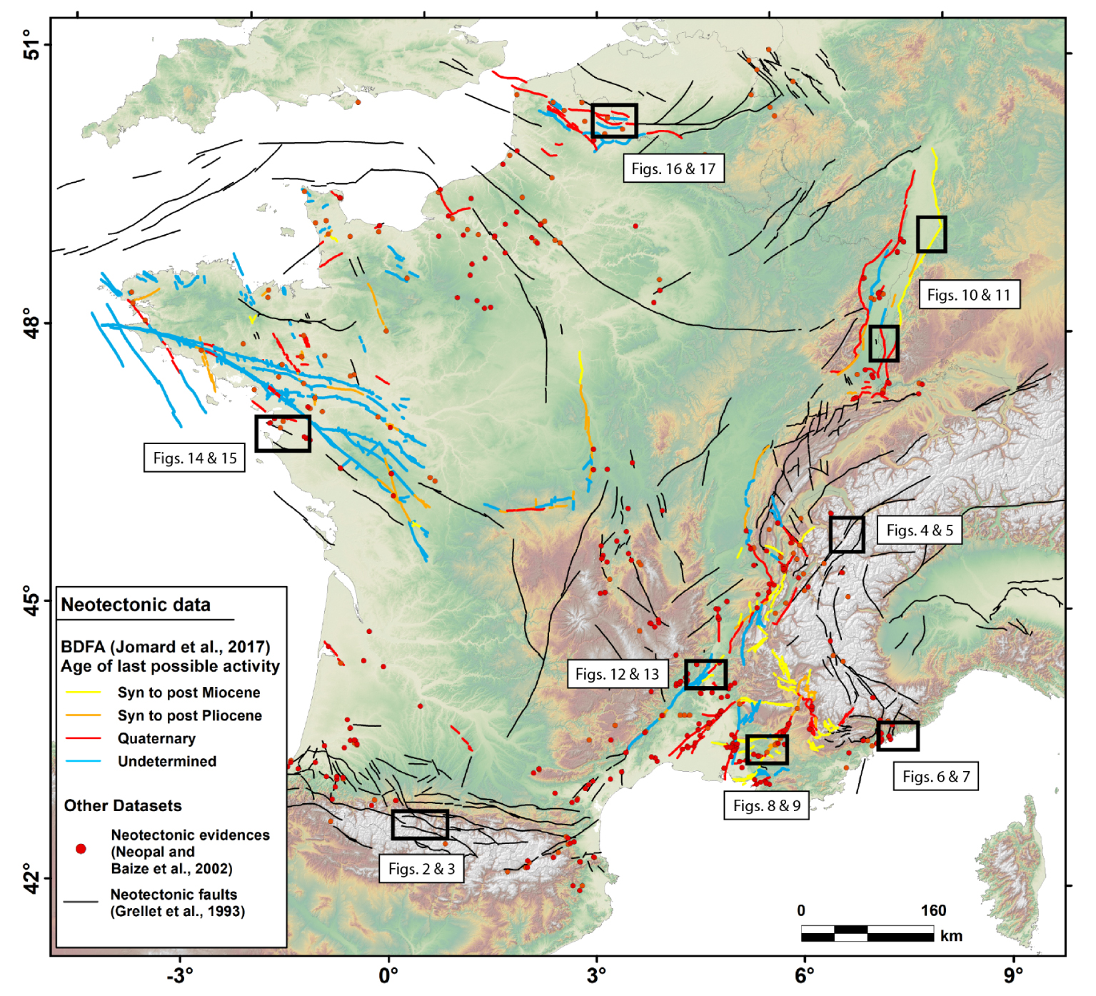
2. State of the art
It is during the last twenty years that the unequivocal explanation of the tectonic deformation and seismicity in mainland France by the Africa–Eurasia convergence has been questioned, largely from the results obtained from geodetic networks. Since the recent installation of these networks, spatial geodesy has failed to show measurable and significant crustal deformation around the main seismotectonic structures [e.g. Nocquet and Calais 2003]. At this time scale of observation, mainland France was usually considered belonging to a rigid block at the resolution of ∼0.25 mm/yr [Nocquet 2012]. It is only recently that Masson et al. [2019], using a field of densified GNSS velocities and alternative calculation strategies, detected regional deformation rates of the order of 10−9 yr−1, based on regionally coherent GNSS velocity fields. Other authors combining modeling and other geodetic data [e.g. Fuhrmann et al. 2015; Mathey et al. 2020], succeeded in detecting relative block movements around major geological structures (the Haute-Durance fault and the Upper Rhine Graben faults, respectively).
Geology and its branch of study of past earthquakes, paleoseismology, which a priori considers longer-term markers of deformation, paradoxically have provided little robust information on activity of faults in France, and on a limited number of cases. The old literature, which is often driven by other objectives than demonstrating active tectonics, is full of more or less reliable “evidences” of surface deformation, which have been partially analyzed and discussed in various compilations in terms of neotectonics [Baize et al. 2002; NéoPal Database; Bellier et al. 2021]. Recently, efforts to integrate these “evidences” in order to define seismogenic sources have been undertaken, first of all in the definition of seismotectonic zones and faults at the scale of the national or regional scale [e.g. Larroque et al. 2012; Baize et al. 2013], then more specifically in the periphery of nuclear sites as part of a joint Institut de Radioprotection et de Sûreté Nucléaire (IRSN)–Environment Ministry effort to define basic parameters characterizing potentially active faults (degree of activity, geometry, kinematics), compiling data available in the literature (BDFA)[Jomard et al. 2017].
Actually, few faults have been investigated in-depth, exploring their relationships with current seismicity, seeking the recent stratigraphic record of past earthquakes, and quantifying their seismotectonic parameters. Indeed, the endeavor to obtain convincing results is big, because the level of tectonic activity is low during the recent and relevant period (i.e. Quaternary), and major morphogenic earthquakes (M > 6) are rare. Moreover, tectonic deformations are easily balanced or erased by external processes (erosion and sedimentation), and then difficult to detect.
Among the faults studied in a thorough and relatively complete manner, we can point out the Middle Durance fault zone which carries a recurrent historical seismicity (one significant event per century, since the sixteenth century), extensively mapped and defined from a geometric point of view, thanks to the analysis of seismic profiles and of microseismicity [Cushing et al. 2008], completed by paleoseismological results [Sébrier et al. 1997]. Recent tectonic activity and geometry of the Vuache fault, the source of the 1996 ML ∼ 5.3 Epagny earthquake [Thouvenot et al. 1998], have been clarified by Baize et al. [2011] and, in the same region, the Holocene activity of the Culoz fault system has been demonstrated by seismic profiles in the Lac du Bourget sediments [De La Taille et al. 2015]. In the Alps, Cara et al. [2017] identified, on the basis of tectonic and seismological data, several surface faults as potential sources of the damaging Chamonix earthquake (Mw ∼ 5.3; 1905), a hypothesis which is currently under investigation (see hereafter, the Vallorcine fault). Thouvenot et al. [2003] and Billant et al. [2015, 2016] explored the Belledonne Fault activity, the major active fault close to Grenoble, respectively with seismological and geological approaches. In a suposedly less active area of France, the study of the Dover Strait faults (Pas-De-Calais), the suspected source of the 1580 Dover earthquake (M ∼ 6) highlighted a remarkable structural signature but limited surface activity, prior to the Lower Pleistocene [García-Moreno et al. 2015]. Paleoseismological studies themselves, demonstrating the coseismic character of the deformations on the fault and possibly the timing of these, were carried out successfully only on a few cases, such as along the Trévaresse fault [Chardon and Bellier 2003; Chardon et al. 2005], the Achenheim [Lemeille et al. 1999] and Reinach faults in the Upper Rhine Graben [Ferry et al. 2005], or on a segment potentially connected to the Nîmes fault [Carbon et al. 1993]. Unfortunately, this kind of extensive studies on geological objects can be considered as exceptions [see more details in the article by Bellier et al. 2021].
3. Studying active faults in Metropolitan France: new studies and perspectives
3.1. Faults in high-elevation mountain ranges
Surface deformation within high-elevation mountain ranges in intraplate areas is not univocal in terms of interpretation. Fault lines with tectonic-like geomorphological expression are common, however sometimes caused by external processes involving gravitational forces at different scales [e.g. Hippolyte et al. 2006; Jomard et al. 2014].
3.1.1. The Maladeta-Bedous fault system in the High Pyrenean Chain
The Pyrenean orogen results from the collision of the Iberian and Eurasian plates mainly between the Upper Cretaceous and the Early Miocene, during the Alpine Cycle [Muñoz 2002]. However, high local reliefs with peak elevations around 3000 m and a mean elevation of ∼2000 m at the Axial zone, contrasts with this apparent relatively old formation and the lack of influence of the present-day Africa–Europe convergence [Asensio et al. 2012; Nguyen et al. 2016; Masson et al. 2019]. An ongoing activity is attested by the seismicity, which is moderate and shows a dominant extension within earthquake focal mechanisms [Rigo et al. 2015] (Figure 2). Some notorious historical and instrumental earthquakes, notably in 1373 and 1923, point toward the North Maladeta fault system as the most likely seismogenic source [Ortuño et al. 2008]. The magnitudes of those events are 6.5 and 5.6, respectively, according to Manchuel et al. [2018]. Additionally, the 1660 event, the larger historical earthquake recorded in the Pyrenees, could also be related to some other faults within the Maladeta-Bedous fault system [Lacan 2008; Lacan and Ortuño 2012; Ortuño and Viaplana-Muzas 2018].
Seismological map of the Pyrenees [modified from Fillon et al. 2021, fault traces from Lacan 2008 and Ortuño and Viaplana-Muzas 2018]. The figure includes the major historical earthquakes, the epicenters with “extension dominant” focal mechanisms [from Rigo et al. 2015], and the SiHEX catalog epicenters [Cara et al. 2015]. (B) Instrumental seismicity projected on the structural cross section of the Central-Western Pyrenees [modified from Séguret and Daignières 1986; Casas-Sainz and Pardo 2004; Lacan and Ortuño 2012]. BF: Bedous Fault; LF: Laruns Fault; PF: Pierrefitte Fault; PMBF: Pic du midi-Bigorre Fault; NMF: North Maladeta Fault; SPFT: South Pyrenean Frontal Thrust; NPFT: North Pyrenean Frontal Thrust; NPZ: North Pyrenean Zone; SPZ: South Pyrenean Zone.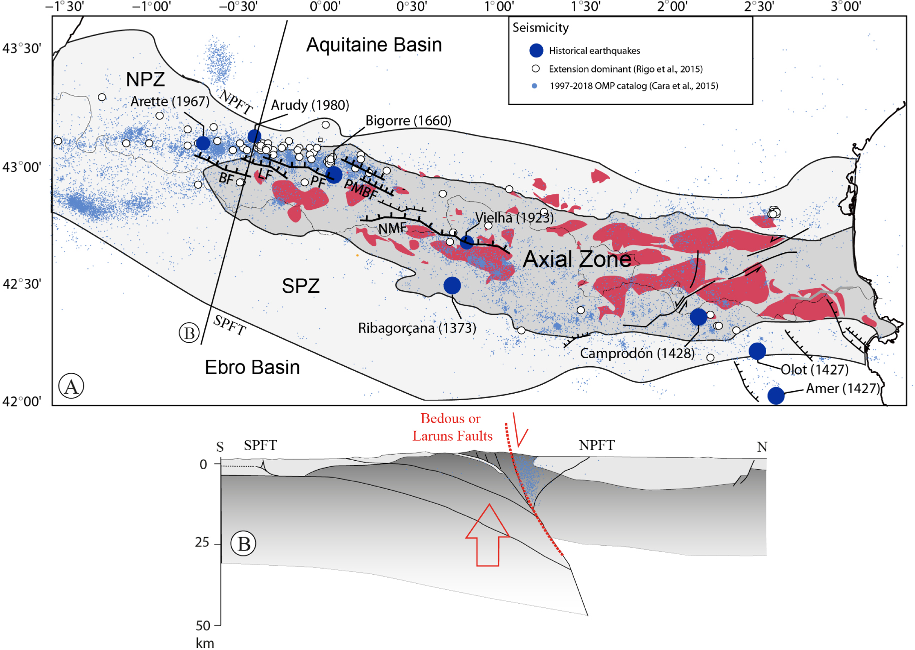
The Maladeta-Bedous fault system is one of the structures accommodating late Miocene to present vertical movements. It stretches over 150 km between the Aspe valley in the Atlantic Pyrenees and the Aran valley in Catalonia (Figure 2A). Individual faults within the system were identified through geomorphological evidences such as the displacement of high-elevation low-relief surfaces (LRS) generated during the Oligocene and Miocene. These LRS are the result of the slow and long-term degradation of the landscape in the absence of a marked fluvial incision (Figure 3A) [Ortuño 2008; Ortuño et al. 2008; Ortuño and Viaplana-Muzas 2018]. Other indicators of activity are river knickpoints and differential incision of valleys and ridges [Lacan 2008; Lacan and Ortuño 2012; Uzel et al. 2020]. The coincidence of the fault traces with the main Pyrenean thrusts led to the proposal that they correspond to a single system [Ortuño and Viaplana-Muzas 2018] that results from the inversion of major thrusts (Figure 2B); [Lacan and Ortuño 2012; Dumont et al. 2015]. The model matches well with the interpretation of instrumental seismicity of Bedous-Pic de Midi de Bigorre faults (Figure 2B) since most of the instrumental seismicity in the High Chain is relatable to this fault system [Lacan 2008; Lacan and Ortuño 2012].
(A) Oblique view of the North Maladeta Fault [modified from Ortuño and Viaplana-Muzas 2018]. Note that the low-relief surfaces’ elevations are higher (orange-red colors) in the footwall block than in the hanging wall block (yellow-orange colors). (B) Field view of the North Maladeta fault eastern termination from the Beret plains.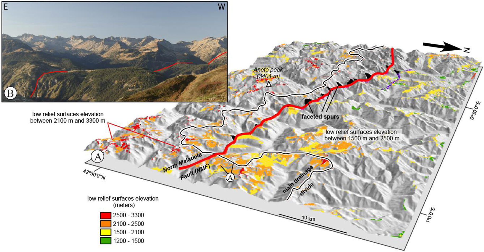
The characterization of the Maladeta-Bedous fault system has benefited from the analysis of 25 m resolution Digital Elevation Models (DEMs) combined with field observations [Ortuño and Viaplana-Muzas 2018]. Significant uplift along the Axial zone is also attested at present by InSAR mapping [Berthelon et al. 2019]. These latter results take advantage of the recent advances in mapping vertical motions by the emergence of satellite imaging with Sentinel-1 fleet deployment where no GPS data is available. They resolve mm-scale differential vertical displacement between the High Chain and the Northern Pyrenean Zone, which are separated by these faults.
A better characterization of the Quaternary activity of the Maladeta-Bedous fault is the next step, with the detection of offset Quaternary landforms and/or sediments (Figure 3B). The analysis of high-resolution LiDAR-derived Digital ground elevation models, progressively available in the Pyrenees [e.g. Ortuño et al. 2017], is regarded as a promising tool to locate young sediments along the trace of the fault system, allowing for trenching analysis as well as the identification of fault bedrock scarps suitable for exposure dating. Additionally, the study of the lacustrine record preserved in the neighboring lakes [e.g. Larrasoaña et al. 2010; Simonneau et al. 2013] could contribute to understand the recurrence of moderate-large earthquakes caused by the active faults in the area.
3.1.2. The Vallorcine Fault in the Western Alps
In the high chain of the Western Alps, the Vallorcine Fault is one of the main seismically active structures at the scale of the last century. Two Mw > 4 earthquakes were associated to this fault system in 1905 [Mw 5.3, Cara et al. 2017] and in 2005 [Mw 4.5, Fréchet et al. 2011], and repeated seismic swarms lasting several months occurred during the past 30 years. The length of the fault is estimated to be at least ∼70 km [Cara et al. 2017].
The fault trace is visible in the morphology on the eastern flank of Aiguilles Rouges massif, at an elevation of 1500–2000 m. It runs linearly over at least 8 km through several glacial landforms, such as polished bedrock and moraines, creating scarps across them. In this context, the limiting factors for observing tectonic deformation at surface are the markers degradation by hillslope processes and the presence of forest patches hiding large parts of the fault trace. An airborne LiDAR survey, performed in 2012 by CEMAGREF/INRAE for studying avalanche corridors, allowed obtaining decimetric resolution DEM. This high-resolution DEM allowed revealing the micro-topography all along the fault trace (Figure 4) highlighting a dominant post-glacial dextral strike-slip movement (Figure 5).
Digital Elevation Model from airborne LiDAR data of the Vallorcine Fault on the eastern slope of the Aiguilles Rouges massif. The high resolution of the 3D image and the penetration of the waves through the vegetation reveal a 8 km long linear fault scarp.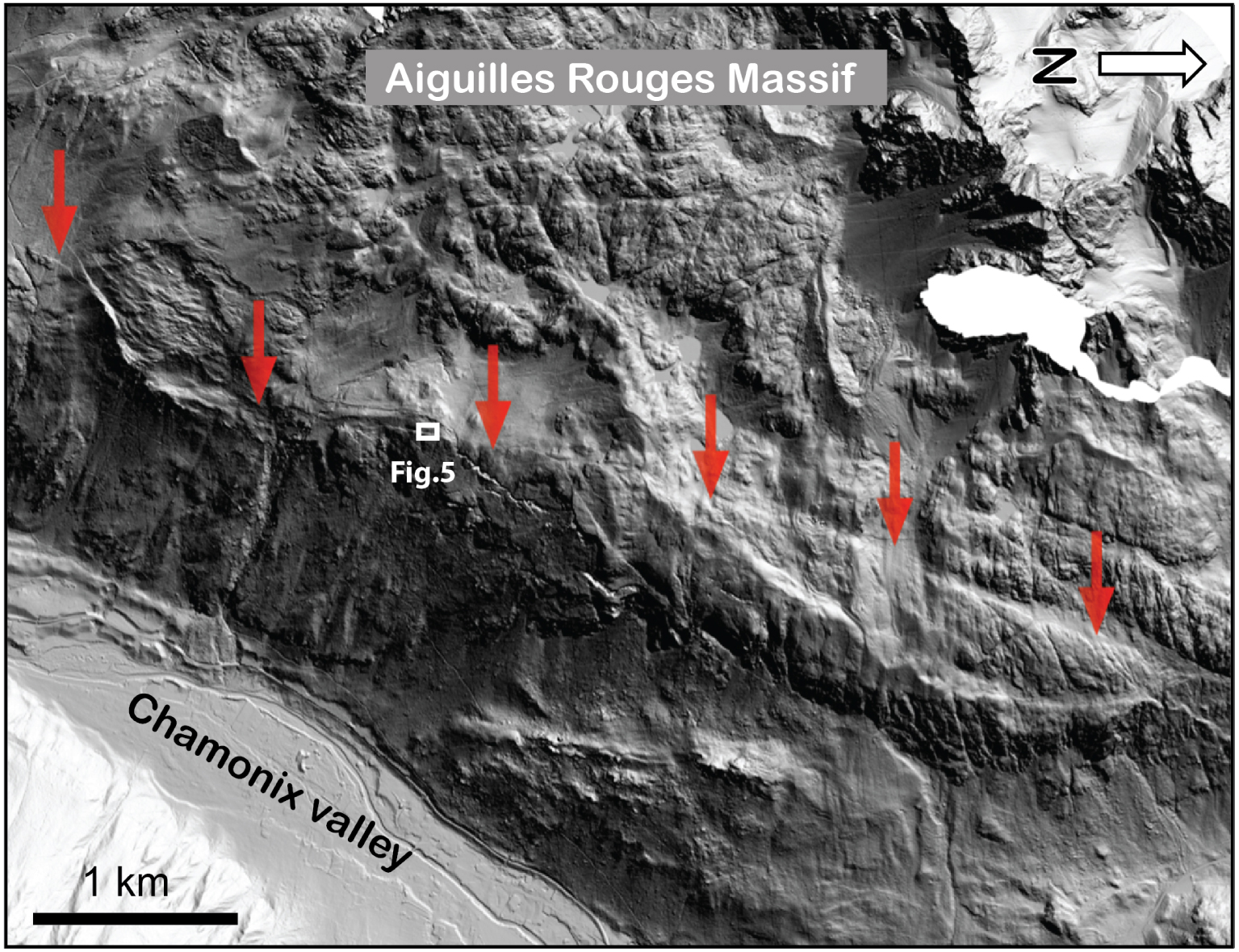
Helicopter (A) and ground (B) views showing a portion of the fault scarp affecting polished bedrock (trees and anti-avalanche scaling the picture). On the ground view (B), people stand in the axis of a gully right-laterally displaced of several meters by the fault. The accurate analysis of different displaced markers revealed a dominant dextral strike-slip kinematics.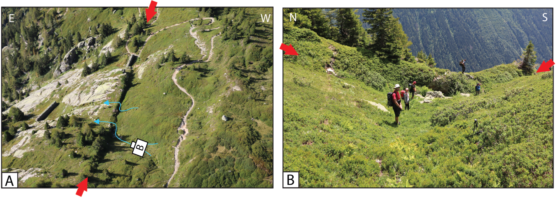
Next steps of the study will involve in situ-produced 10Be cosmogenic dating of an offset moraine to estimate the slip rate along the Vallorcine fault over the upper Pleistocene–Holocene period, while paleoseismological investigations will be carried out, typically within sites as the one shown in Figure 5, to constrain the ages of the past surface-rupturing events. The area could also benefit from a detailed analysis of the InSAR (Sentinel-1) based vertical displacement map, which revealed to be an appropriate tool to decipher local relative motions at the scale of the Western Alps [Mathey 2020].
[Modified from Larroque et al. 2011]: (A) Map of the Ligurian fault system. (B) Path of the HROV Ariane during the 2018 dive (colored dots). “Zone A” shows the place where mounds are fewer on the seafloor. The bathymetry of the Marcel fault acquired during the 2006 MALISAR survey is plotted in color (meters). The sonar swath profile images the area between the white lines, the center of the sonar swath (nadir) being the middle one [modified from Larroque et al. 2011]. a, b, c, and d point to the locations of video extracts from the HD camera showing different features identified on the seafloor (see Supplementary Material).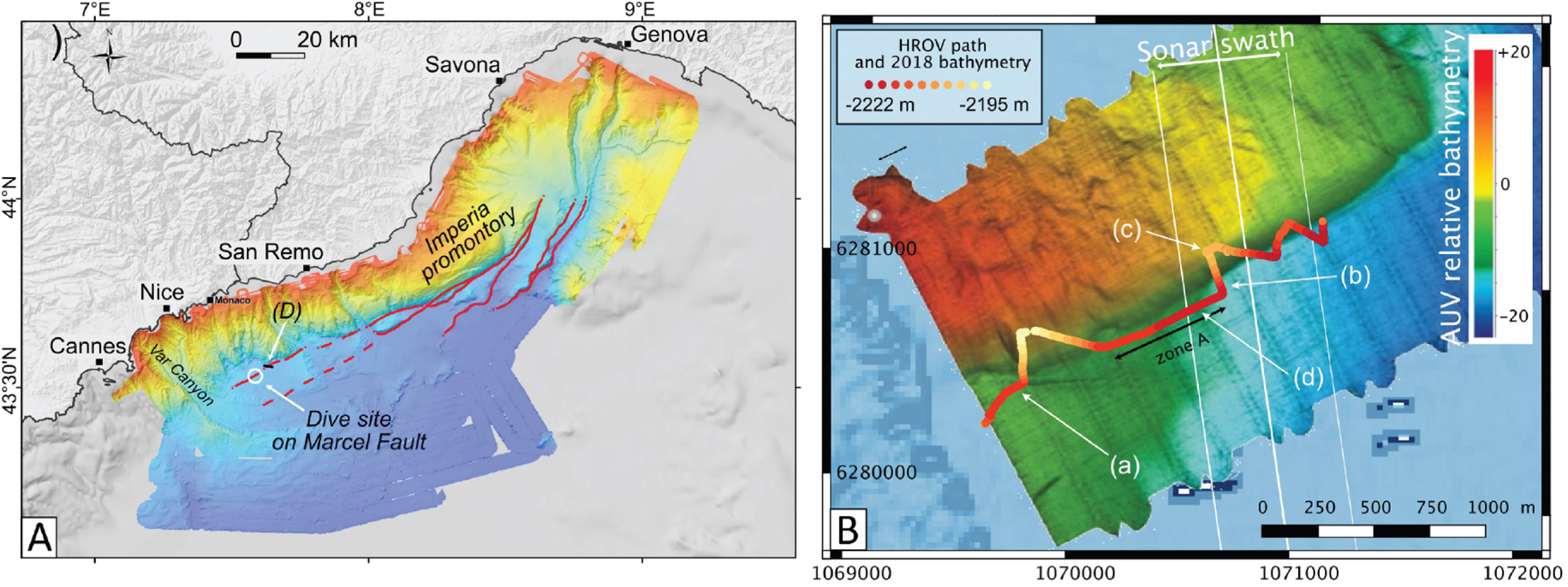
3.2. Faults in the mountain range forelands
Foreland surface faults are abundant in southeastern France, reflecting the successive Tertiary tectonic phases. Some of them are suspected to be seated in a décollement layer (Triassic evaporites), in agreement with shallow to very shallow historical and instrumental earthquakes. However, the relationship between cover and deep-seated structures is poorly understood and one can provisionally suspect that basement-sourced large events could have ruptured the surface in the past.
(A) Sonar swath profile crossing the Marcel scarp (see Figure 6B). (B) Chirp (Mud penetrator, 3.5 kHz) profile on the eastern part of the Marcel scarp. Black lines are reflectors shifted on both side of the faults, yellow units are Mass-Transport Deposits, green- and blue-colored units highlight the offset of Quaternary sedimentary deposits.
3.2.1. The submarine Ligurian fault system
The southeast coast of France area marks the southern margin of the Alpine Range, and northern boundary of the Ligurian oceanic domain. This area records both onland and offshore shallow seismic activity with mainly moderate magnitude and few strong events [e.g. Béthoux et al. 1992]. The strongest event [Imperia earthquake: Mw 6.7–6.9; Larroque et al. 2012; Manchuel et al. 2018] took place offshore on February 23, 1887 within a sequence of seven strong earthquakes during the XIX century [Larroque et al. 2021].
In the past decades, several oceanographic campaigns have acquired traditional marine geophysical data (multi-channel seismic reflection and multibeam bathymetry) that allowed characterizing the margin, whose structure is primarily inherited from the Oligo-Miocene opening of the Ligurian marginal basin [e.g. Rehault et al. 1985; Sage et al. 2011], and whose morphology is furthermore marked by several active submarine canyons and failure scars [e.g. Migeon et al. 2011]. The most recent data were used to identify a 80 km long ENE–WSW striking fault system running along the base of the Ligurian margin, offshore and east of Nice [Larroque et al. 2011] (Figure 6). The Ligurian fault system is thought to be responsible for the Imperia earthquake and an induced tsunami [Ioualalen et al. 2014]. While focal mechanism analysis indicates that this system accommodates present-day compression at depth, mainly along northwards dipping planes [e.g. Larroque et al. 2009], the nature of the faults near the surface is unclear. Multi-channel seismic reflection data only image the crust up to 3 km below seafloor and show that the faults are sub-vertical [Larroque et al. 2011]. Several of these faults ruptured the sea floor creating fault scarps. In order to get new insights about the nature and the age of the scarps, direct observations were implemented using Remotely Operated Vehicles (ROV) mounted with high-resolution optical cameras. This study was inspired by the pioneering work by Escartín et al. [2016] and Billant et al. [2019] within the Lesser Antilles and the study of the 2004 Mw 6.3 Les Saintes surface-rupturing event.
On December 5th 2018, a dive was performed using the Hybrid-ROV Ariane (Ifremer) operated from the R/V L’Europe, during the scientific cruise TELEPRESENCE (PIs: O. Soubigou and F. Leclerc) along the Marcel fault scarp, belonging to the western part of the Ligurian fault system that had been investigated in 2006 and 2007 during the MALISAR surveys (Figure 6A). Multibeam bathymetry reveals a clear 15 to 30 m high offset of the seafloor above the inferred location of the fault (Figure 6B). A sonar image acquired across the fault scarp revealed grooves imprinted on the scarp surface allowing the assumption that the Marcel fault was outcropping at this location (Figure 7A) [Larroque et al. 2011]. Showing reverse and left-lateral motion, the grooves’ geometry is consistent with the present-day fault kinematics deduced from focal mechanisms, and their presence was therefore interpreted as slickensides witnessing active reverse faulting. The HROV dive lasted 3 h at a mean depth of 2280 m b.s.l., and was recorded by two cameras, the HD one allowing a forward viewing angle, the other showing the seafloor from the right side of the vehicle [IFREMER 2018]. The HROV Ariane proceeded at 1.5–2 m above the seafloor, heading NE, and zigzagging across the fault scarp at the very location of the sonar image in an attempt to confirm the earlier observations (Figure 6B). Overall, the seafloor is covered by hemi-pelagic sediments. The scarp is hardly visible but revealed by a 15–20 m bathymetric smooth change recorded by the HROV. However, we did not identify any morphology that would resemble the grooves along the scarp. The only noticeable features are sub-metric forms (e.g. rounded mounds and tunnels of probable biologic origin, burrows, dark spots of possibly a terrestrial origin as associated with plant debris and litters, see figure in Supplementary Material). All in all, these features are unevenly distributed on the seafloor, their position seems unrelated to the scarp [unlike fluid seepage identified along faults in the Marmara sea, e.g. Zitter et al. 2008]. The fact that the grooves were not identified indicate that either the fault has been recently covered by sediments, hiding the slickenlines, or that the seafloor in this submarine environment is subjected to current activity that can carve, produce, and erode such morphology. Such current activity cannot be linked with the overall Western Mediterranean circulation as the only known current in the area is the Ligurian Current whose maximum recorded depth is about 500–600 m b.s.l. [Béthoux et al. 1988]. Even during stormy periods, large-scale rapid currents only reach a maximum depth of 1100–1200 m [Taupier-Letape and Millot 1986] which is still too shallow to directly impact the area of the Marcel scarp 2280 m b.s.l.
In fact, it seems likely that different types of turbulent gravity flows initiated upstream, and could have flown along the base of the scarp since 2006–2007, leading to the erosion of mounds, transporting plant debris and litter, and depositing sediments. These phenomena contribute to rapidly transform the seafloor morphology. This observation is supported by a chirp profile (oblique to the scarp) acquired during the 2006–2007 Malisar cruise, across the eastern part of the Marcel fault, that display folded and faulted Quaternary sediments, covered by a submarine landslide (Figure 7B).
This first experiment shows that the HROV Ariane is a promising tool for the investigation of submarine fault scarps. It allows very precise imaging as well as surface and/or core sampling. Future dives will focus on scarps that are located in a priori more protected environments, as the ones forming the Imperia promontory in the eastern part of the Ligurian fault system where scarps showing tectoglyphs will be sampled to tentatively date their exhumation.
3.2.2. The Provence faults
In Provence, paleoseismologic investigations were carried out to identify faults with surface-rupturing events during the Late Quaternary, and have been mainly focused on two structures, the Middle Durance Fault system (MDF) and the Trévaresse fault (TF) because they correspond to areas with the highest density of historic and instrumental seismicity [see Bellier et al. 2021]. Evidence of past earthquake events were found on those fault systems, however no available samples were gathered in the different trenches for dating the events. The timing of these past earthquakes, as well as the recurrence intervals between them, are therefore lacking. Other potentially active faults have been studied in Provence, but the main challenge remains uncovering potential deformed Quaternary surfaces and fault scarp morphologies. The competition between denudation rates [30–140 mm/ka, e.g. Siame et al. 2004; Godard et al. 2016; Thomas et al. 2018] and estimated slip rates along faults [30–100 mm/ka, e.g. Cushing et al. 2008] implies that tectonic fault scarps are not well preserved in the morphology and therefore remain unmapped. In addition to this problem of preserving surface traces of ruptures, there is that of the vegetation and the anthropic constructions masking the morphology.
Recently, airborne LiDAR acquisitions have been used in Provence to generate DEM corrected from the vegetation and human-made structures along the Trevaresse and the Maragrate faults [Thomas et al. 2018, 2021]. Along the TF fault zone, the Lidar data allowed highlighting the fault segments across which had been carried out the first trench investigations within alluvial fan deposits [Chardon et al. 2005; Nguyen et al. 2007]. It also allowed detecting new fault segments [Thomas 2018] (Figure 8). Along the Maragrate fault (MF), 30 km east of the TF area, south of the village of Vinon-sur-Verdon, the LiDAR data allowed evidencing a 300 m long morphological scarp, which has been interpreted as resulting from both differential erosional processes and the presence of a fault between stiff Miocene layers and loose Pliocene deposits (Figure 9A). The high-resolution DEM allowed detecting a morphotectonic signature associated with the MF. But its extension is limited due to the incision and alluvial processes in the Maragrate valley [Thomas et al. 2021]. Complementary geophysical investigations were carried out for imaging the extent of the MF contact at depth beneath the Maragrate valley deposits, and for driving subsequent paleoseismic investigations. Among the three opened paleoseismic trenches, one trench provided age constraints on the chronology of the sedimentary units and their deformation thanks to the Optically Stimulated Luminescence (OSL) method that allowed dating alluvial and colluvial units (Figure 9B). Results showed that the fault (mainly reverse with potentially a slight sinistral component after observed slickensides) affects Quaternary 195.9 ± 30.8 ka conglomerates, and had not ruptured the ground surface since 19.4 ± 1 ka. This result suggests recurrence intervals for surface-rupturing events of several thousand years or even tens of thousands of years.
(A) Aerial view from Google Earth of the “Ganay” area along the Trévaresse fault (coordinates in Lambert 93). (B) 1 m-resolution LiDAR DEM of the area, with a sun illumination at N315° E [after Thomas 2018]. The red arrows highlight the topographic scarps where fault zones were identified. TRF: Trévaresse Reverse Fault, EF: Ermitage Fault. Yellow numbers indicate trench studies: 1: Nguyen et al. [2007], 2: Chardon et al. [2005]. The comparison of the two pictures clearly illustrates the relevance of LiDAR acquisition to map the scarps in covered areas.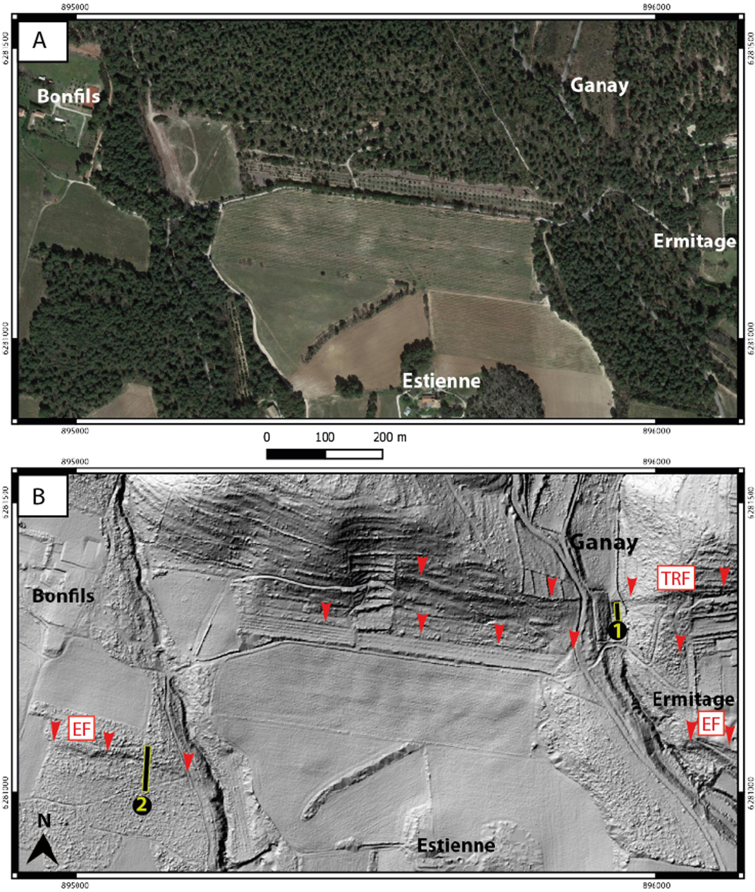
[Modified after Thomas et al. 2021] (A) Shaded relief LiDAR DEM (30 cm resolution) of the Maragrate valley area. Red arrows point to the N120° E trending Maragrate fault scarp (visible under the vegetation). (B) Photomosaic of one of the southern walls of one of the trenches opened across the Maragrate fault in 2016 (see Figure 9A for location) with location of OSL samples [see [Thomas et al. 2021] for more details]. Note the sharp contact between the dark red clays interpreted as fault gouge (oblique marks are backhoe strokes) and the loose yellow conglomerates.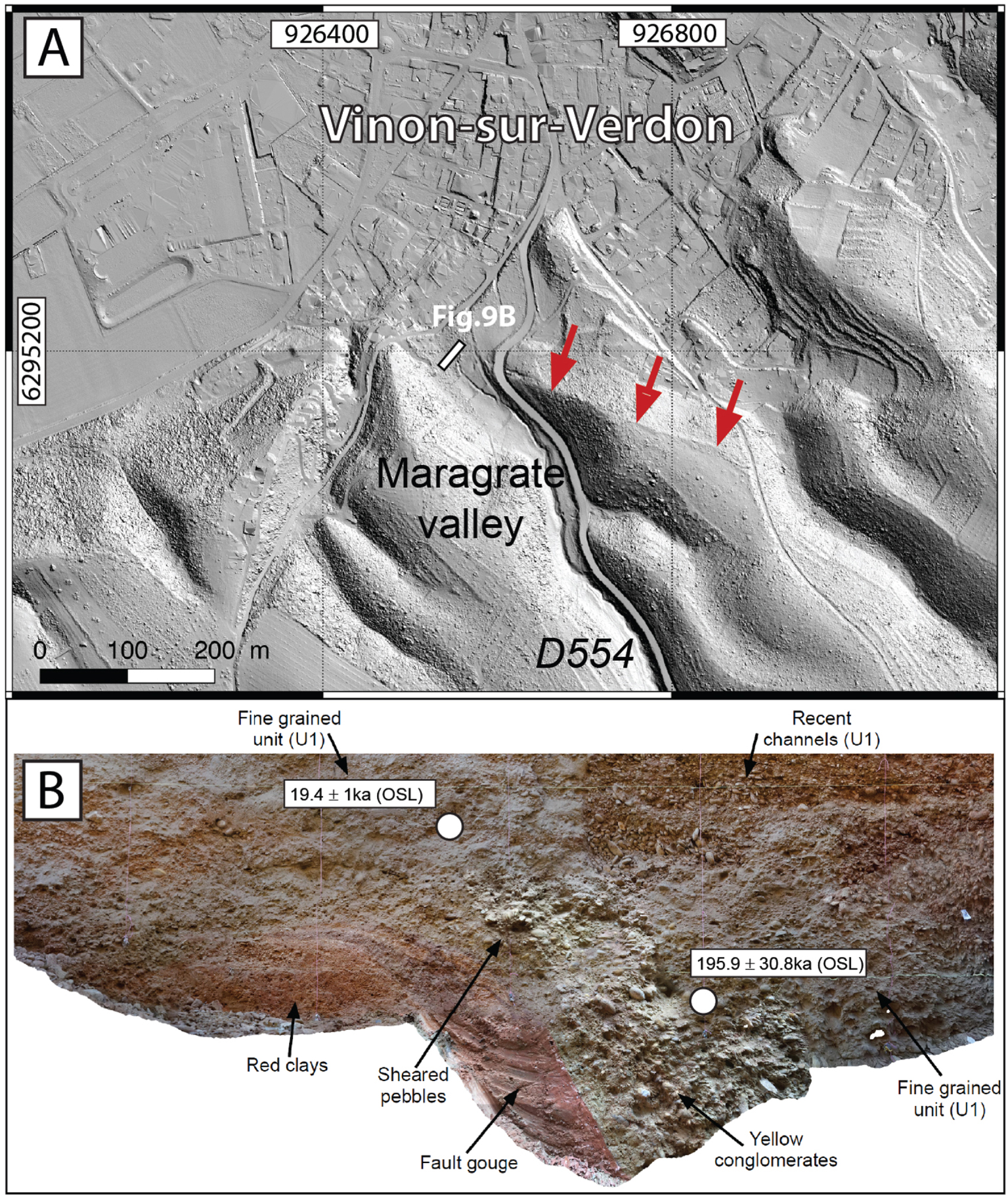
New investigations are planned to re-investigate the Trévaresse fault zone, where a similar depositional setting (alluvial) has been observed, in order to provide age constraints on the paleoseismic history of the fault [cf Chardon et al. 2005]. We will use in particular the OSL dating method to bracket the different surface-rupturing events that will be characterized in trenches.
3.3. Faults within the Upper Rhine Graben area
Faults in the Rhine Graben are mostly inherited from the Oligocene extension and Mio-Pliocene strike-slip regime [Rotstein and Schaming 2011]. Their potential reactivation during recent times, including the Pleistocene and Holocene, is mostly accepted, and the current kinematics of faulting processes inferred from seismicity, is strike-slip [e.g. Edel et al. 2006]. However, the kinematic expression of active tectonics could not be yet inferred from morphological and geological expression at the surface. In several places, salt diapirism may control the faulting, including up to the ground surface.
(A) Sketch map of deep seismic lines location (orange lines) performed within the southern zone of the Upper Rhine Graben. The dots are available borehole locations (red are for petroleum ones). Dashed pink areas show saliferous unit location at the base of Plio-Quaternary [from Lutz and Cleintuar 1999]. Section underlined in green across the Weinstetten diapir and associated fault is presented in (B) [detailed map for fault locations from Behrmann et al. 2003]. This section is a composite line where profiles SBAD7602 and KAIS7701 are merged. Boreholes used to calibrate seismic units are indicated in blue. Red horizon: Plio-Quaternary lower limit, yellow horizon: top of the gray collection (i.e. lower limit of Chattian (Upper Oligocene)), green horizon: top of upper saliferous, orange horizon: top of medium saliferous, pink horizon: top of lower saliferous, blue horizon: top of Jurassic.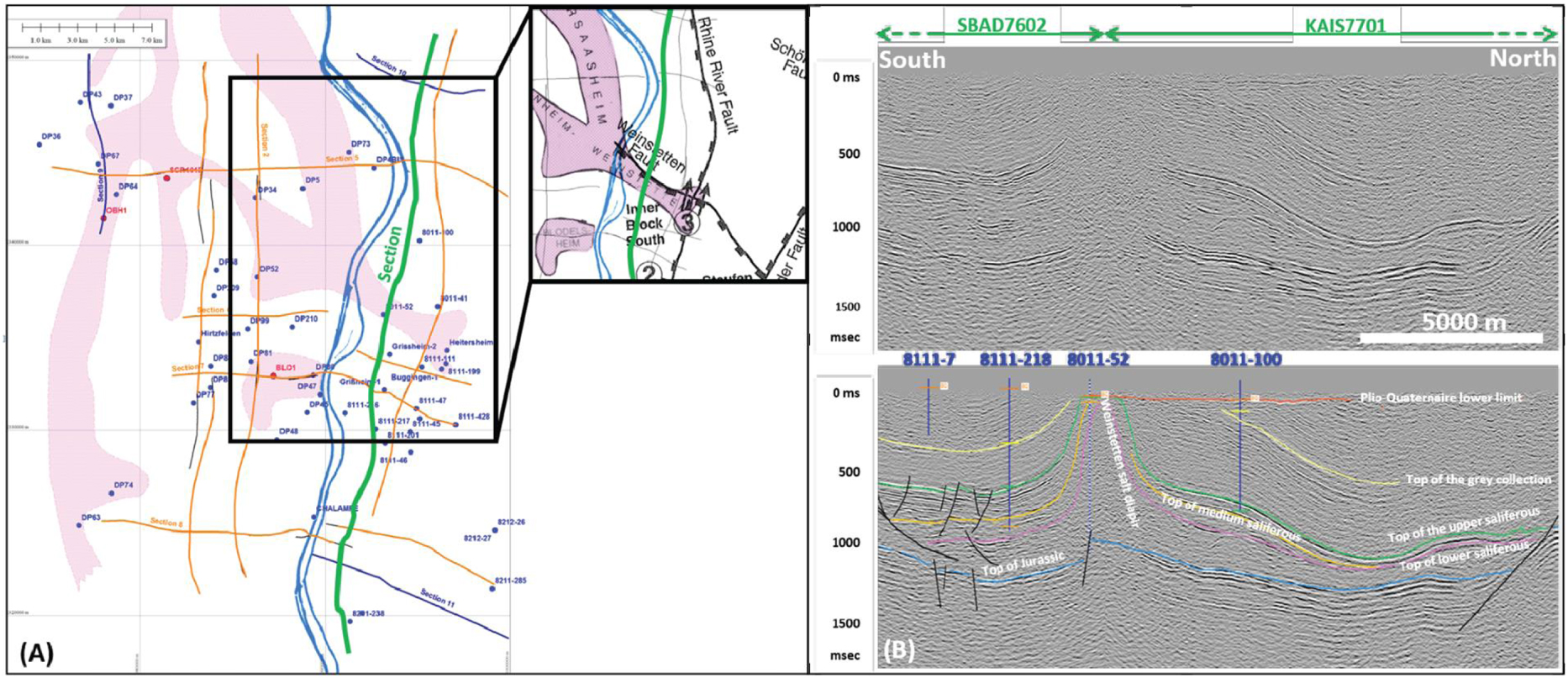
3.3.1. The eastern border faults
In the last twenty years, several studies have been focusing on the Upper Rhine Graben (URG) and its fault activity during the Quaternary (see references hereafter). This mega structure has been active during the Oligocene extensional period, similarly to the Cévennes fault system (CFS), generating large-scale normal faults.
(A) 3D view (vertical exaggeration ×2) of a 15 km long section of the eastern Main Border Fault of the Upper Rhine Graben and its surrounding area, in Germany (Ettlingen, close to Karlsruhe), that separates the Black Forest Massif and the Rhine River Valley. This graphic illustrates the clear scarp (a–b) associated with the inherited Oligocene fault, between Triassic sandstones (Buntsandstein) in the footwall and the Tertiary to Quaternary deposits in the hanging wall, and the smoothed facets, several beheaded streams in the hanging wall. The sharpness of (a–b) main scarp, and the occurrence of parallel scarps within the valley, at the toe of the Tertiary hills (c–d) and within the Quaternary filling itself (e–f), strongly show a recent surface activation of the fault system, which is confirmed by the Oberweiller trench walls (B) where Late Pleistocene to Early Holocene deposits are faulted beneath a scarplet a few tens of meters west of the Main Border Fault.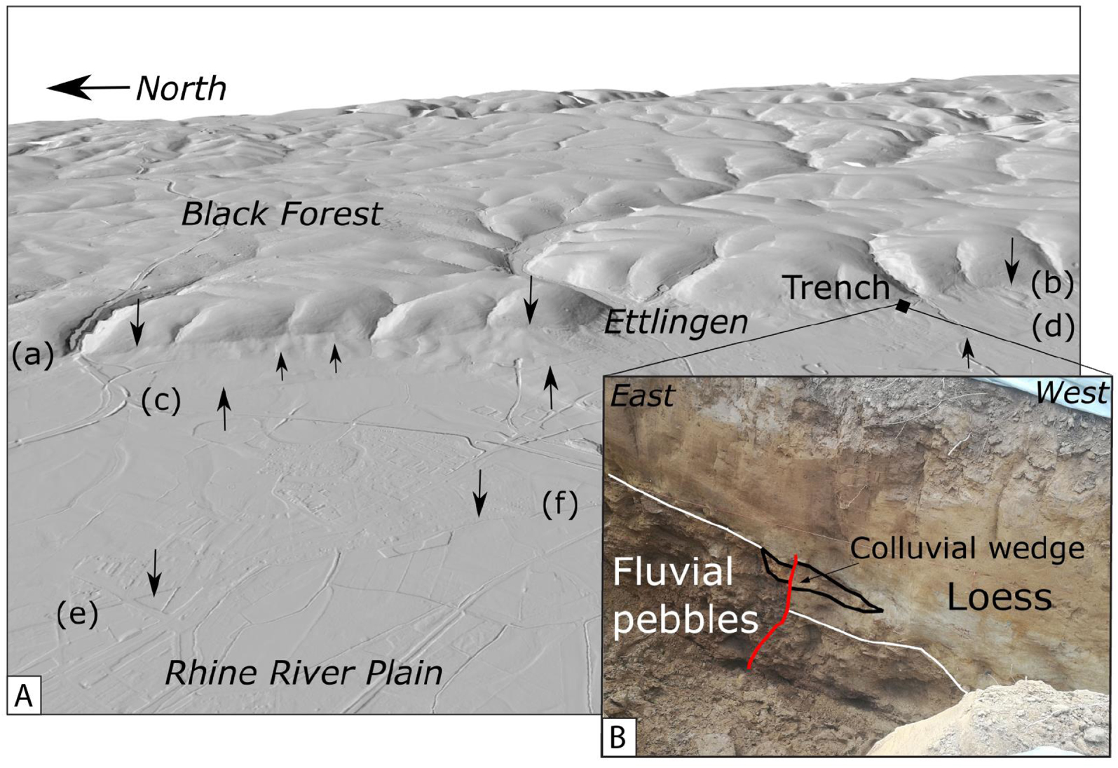
Examples of tectonic studies include: (1) the synthesis produced in the framework of an European project [GeORG team project 2013], which provides a service for producing geological sections and mapping geological interfaces from geophysical and drilling data, (2) specific geomorphological and paleoseismology studies of active fault strands in the Quaternary on the western [Lemeille et al. 1999; Peterset al. 2005; Peters and van Balen 2007] or southern [Ferry et al. 2005] edge of the URG. Until 2008 and mainly in recent years, the eastern side of the URG has remained little studied. Bertrand et al. [2006] and Nivière et al. [2008] began to investigate the eastern and southern boundary of the graben thanks to geophysical analyses along the Rhine River, and a regional analysis in the Freiburg-im-Breisgau (Fribourg en Brisgau) region based on low-resolution drilling and geomorphology data, respectively. More recently, the use of new tools, such as the 1 m LiDAR coverage of the Baden-Würtemberg region [Reicherter et al. 2021], as well as new accurate processing of old seismic reflection data opened the gates to the improvement in the characterization of the eastern fault network. Conventional approaches (paleoseismological trenches) also opened new perspectives for a better knowledge of the seismic hazard of this region.
In the southern zone of the URG, some of the faults are buried and only deep geophysics can give new insights on their location, geometry and kinematic history. In past years, a large dataset of seismic lines, produced in the frame of petroleum exploration, both in France and Germany, was built by EDF. A total length of around 240 km of seismic profiles, acquired during the 70’s and 80’s, has been re-processed and interpreted, by using borehole data available to calibrate seismic lines (Figure 10A). Figure 10B allows to image the Weinstetten salt diapir geometry and the associated Weinstetten Jurassic fault below, where the diapir could have been initiated. This example shows the benefit of using such existing deep data in increasing geological and tectonic knowledge at depth.
Additional data at the subsurface scale (e.g. UHRS seismic profiles), remains crucial to address the question of activity of inherited buried faults. In this same area, the high-resolution topography reveals the Quaternary reactivation of the nearby Rhine fault and the border fault, with deflections or offsets of the drainage network across the Main Upper Rhine Graben Border Fault [Rudmann 2019] and with alluvial surface offset (Staufen alluvial fan) [Baize et al. 2017]. The potential relative displacements observed are consistent with left-lateral kinematics, with a vertical component. In the northern region, near Karlsruhe, 1 m-resolution LiDAR data are used for the first time to illuminate a series of parallel scarps associated with the main border fault escarpment (Figure 11A). Those features are spaced a few tens to hundreds of meters apart. The major fault is remarkably imaged by its large-scale morphological signature [Diederichs 2020], with triangular facets (probably partly associated with the exhumation of the inherited Oligo-Miocene fault), as well as perched and/or inverted valleys. Lateral deflections of the Plio-Pleistocene drainage system, consistent with cumulative left-lateral slip, have been identified and, for the first time in this region, bedrock seated faults affecting Late Pleistocene to Holocene sediments have been documented with oblique slip [Reicherter et al. 2021], suggesting the occurrence of paleoearthquake(s) less than a few tens of thousands of years old (Figure 11B).
These results, essentially qualitative, will be refined and deepened with new paleoseismic trenches, geomorphological surface dating (combining in situ-produced cosmogenic nuclides, 14C and OSL methods), and suitable geophysical instrumentation, to produce quantitative parameters associated with active faulting. Other tools, such as InSAR mapping of ground displacements, or monitoring of ground deformation, could be applied at the regional scale associated with GNSS campaigns, or even at more local scales around geothermal sites or potash mines where they could improve the knowledge of active structures.
3.4. Faults in margins
In the Mainland French margins, shallow to deep (0 to 20 km) seismicity is distributed over large areas within the Variscan massifs (Central, Armoricain) and surroundings, with no concentration or alignment around or along mapped faults, including those which affect Plio-Quaternary deposits. Seismicity is remarkably rare inside the so-called Meso-Cenozoic basins (Paris, Aquitaine) despite a similar basement at depth, suggesting a role of the thick sedimentary pile on basement rheology [e.g. Petit et al. 2019]. Several faults, inherited from Paleozoic times, are potentially active in both areas and their long-term deformation is expected to be tectonic in origin, potentially modulated by transient forces [e.g. Ampuero et al. 2019]. Unfortunately, the whole area almost lacks any in-depth study of faults.
3.4.1. The northeast termination of the Cévennes fault system
The CFS corresponds to a major polyphase crustal structure, inherited from the Variscan orogeny. This NE–SW trending, 120 km-long fault system is located at the boundary between the Massif Central crystalline basement and the sedimentary basin of southeastern France. Several authors stated that this fault system could have been active and mainly transcurrent during recent times, based on geomorphological analyses, however missing definitive evidence of past surface-rupturing events and leading to intense debate [e.g. Bishop and Bousquet 1989; Lacassin et al. 1998; Ambert et al. 1998].
(A) Simplified geological map of the northeastern termination of the CFS within the region of the Le Teil showing the surface rupture associated with the 11-11-2019, Mw 4.9 Le Teil earthquake along the ancient Oligocene normal LRF (red lines). The map depicts as well the location of other potential active faults that will be investigated: PCF: Pontet-de-Couloubre Fault; MF: Marsanne Fault [modified from Ritz et al. 2020]. (B) 0.25 cm resolution LiDAR-derived shaded DEM of the central part of northern section of the La Rouvière Fault along which occurred the 11-11-2019 Le Teil earthquake (red stars are surface rupture observations); note the Oligocene cumulative normal fault scarp in the morphology. (C) Field photo of the fault scarp (the limestone scarp has recently be exhumed by anthropic activity). (D) Field photo showing a paleorupture across the periglacial sediments.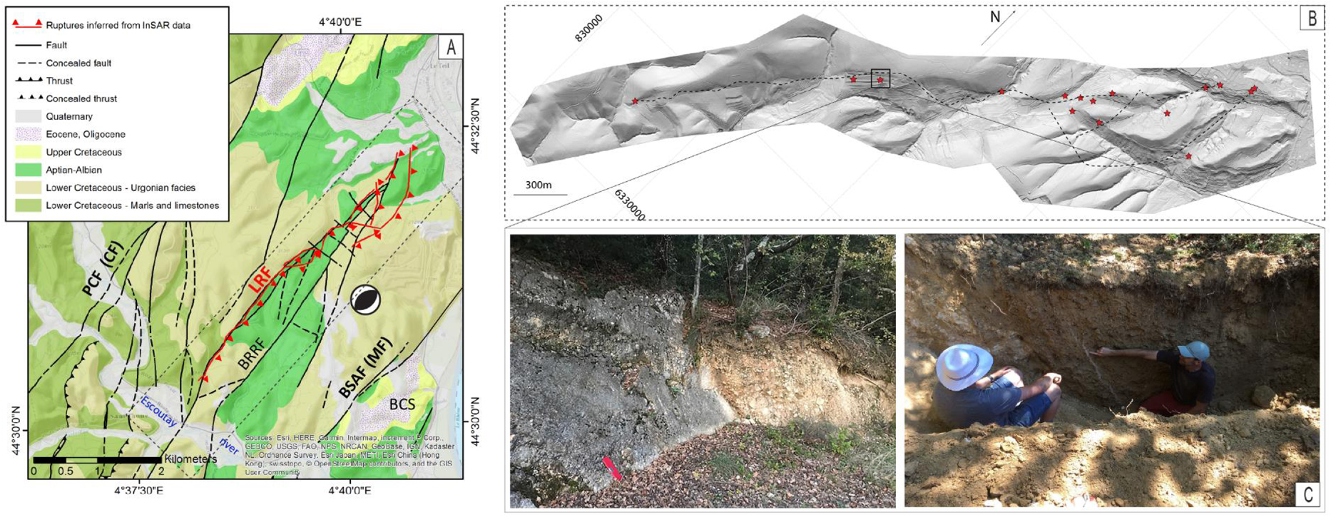
On November 11th, 2019, the Mw 4.9 Le Teil earthquake occurred on the northeastern termination of the CFS along a segment called the La Rouvière fault (LRF). This very shallow (1–1.5 km) moderate magnitude and reverse-faulting event inverted an Oligocene normal fault which was not assessed to be potentially active [see Jomard et al. 2017], causing surface rupture and strong ground shaking [Ritz et al. 2020; Cornou et al. 2021; Causse et al. 2021; Vallage et al. 2021] (Figure 12A).
The morphology along the fault shows no evidence of cumulative reverse faulting during the Quaternary, which leads to the question whether the fault was reactivated for the first time since the Oligocene during the Le Teil earthquake, or if it had broken the surface before, during the Quaternary period, but could not be detected. Instead, the 0.25 m-resolution LiDAR DEM (Figure 12B) evidences a preserved Oligocene cumulative normal fault scarp between NW (stiff Barremian limestones) and SE (loose Bedoulien marls) compartments, smoothed by the erosion and the accumulation of colluvium against the fault plane (Figure 12C). To tackle the past seismic and kinematic history of the LRF, paleoseismic investigations were launched in 2020, all along the LRF to analyze and characterize evidences of paleo-ruptures in Quaternary deposits. Despite a context of incised hilly reliefs with steep slopes—which is not a priori the best setting for preservation of sediments and then of paleoearthquake traces—14 trenches were dug in aeolian deposits and slope colluvium lying against the ancient LRF normal fault mirror carved in the Barremian limestones. Among this set, five trenches yielded favorable Quaternary deposits to document deformation suggesting that one paleo-event, perhaps two, occurred with kinematic characteristics (sense of movement, amount of displacement) similar to the 2019 event [Ritz et al. 2021]. The radiocarbon dating of the deformed units (“bulks” collected from the colluvium clayey-silty matrix) suggests, in particular, that at least one event (penultimate, prior to the Le Teil earthquake) occurred in the past 13.5 Ka (Figure 12D). The fact that these events are not preserved in the morphology could be explained by the small amount of displacement and a long recurrence interval, consistent with the low strain rate (0.5–1.0 × 10⁻⁹ yr−1) measured by GPS at the regional scale [Masson et al. 2019].
The reactivation of LRF during the Le Teil earthquake, located in the middle of the northeastern termination of the CFS network raises also the question of knowing whether other faults of the CFS have produced such kind of surface-rupturing event in the past. A preliminary field reconnaissance along mapped faults document some evidences of possible fault reactivation in Quaternary sediments. In parallel to the first set of paleoseismological investigations carried out along the LRF, detailed geophysical surveys were performed at the intersection areas between the CFS faults and the Quaternary markers, especially at the Marsanne fault which bounds the northeastern CFS termination in its southeastern border. This fault is mentioned as a potential active fault in BDFA database [Jomard et al. 2017].
A UHRS (Ultra High-Resolution Seismic) survey [Vergniault et al. 2019] on a site where the Marsanne fault is mapped below Plio-Quaternary deposits has been performed (Figure 13A). The seismic section shows an interruption of the horizontal continuity of some reflectors that are interpreted as the occurrence of the Marsanne fault (Figure 13B). Nevertheless, processing of S-wave seismic data remains a difficult task, especially when velocity contrasts are high, which can lead to biased images and interpretations. Opening trenches within the overlying young deposits where the singular geological deposit geometries are observed at depth on the UHRS line will allow analyzing the Quaternary activity of the Marsanne fault (Figure 13B).
(A) Location of UHRS profile across the Marsanne fault (MF). See Figure 12 for map location at regional scale. LRF = La Rouvière Fault. (B) Seismic line (lower section = potential interpretation).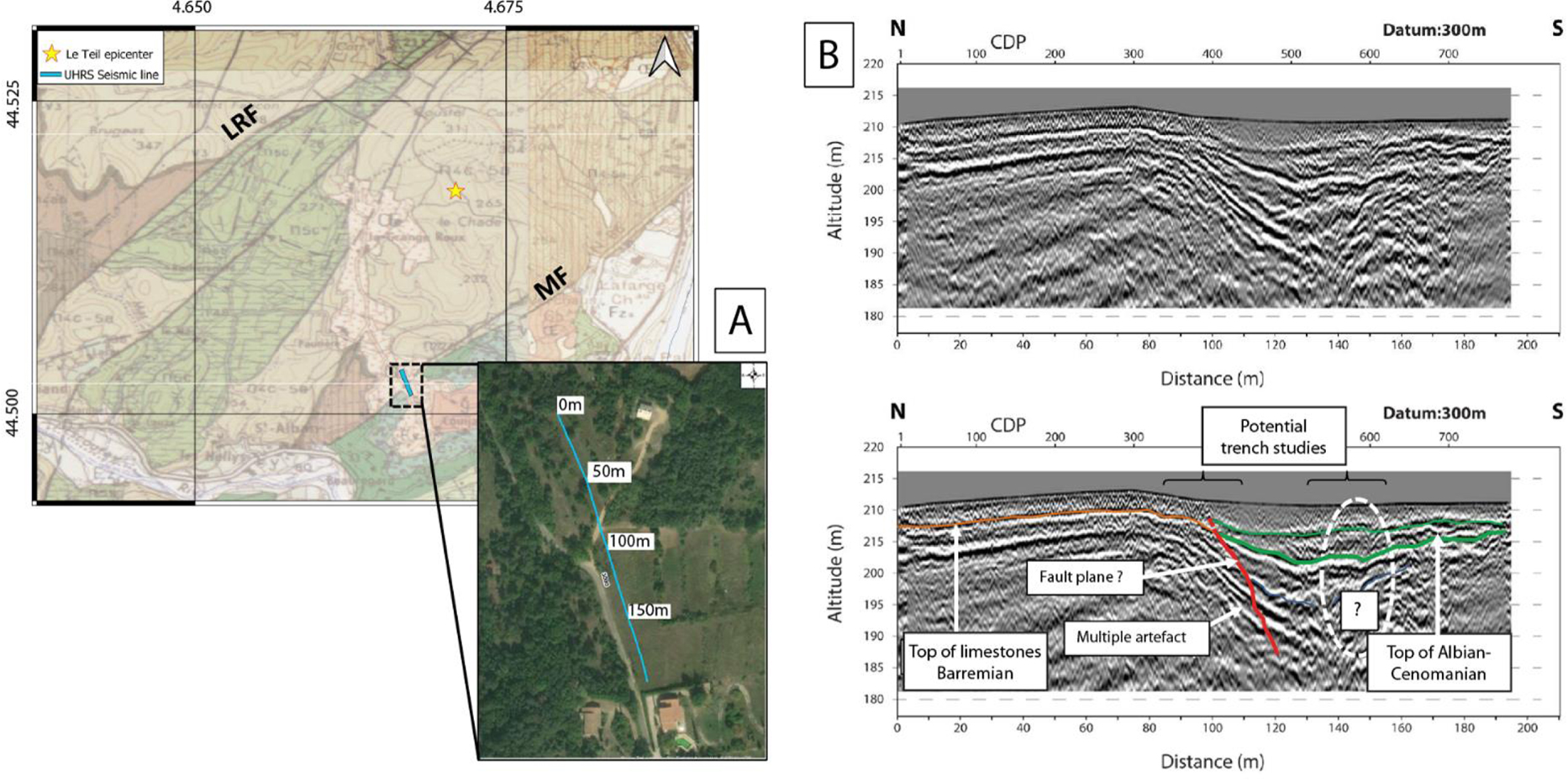
Further studies will also include geomorphological analyses at the regional scale. In particular determining the ages of the abandoned fluvial terraces across the CFS (e.g. along the Escoutay river), using cosmogenic (both surficial and burial ages) and ESR dating methods, allowing the determination of the incision rates and analyzing their potential variations. This approach, which has been performed across the central section of the CFS along the Hérault River between Ganges and Saint Bauzille-de-Putois, revealed a difference of incision rates of a factor of two, between the NW and SE fault compartments [Malcles 2021].
3.4.2. The Machecoul Fault within the South-Armorican platform
The recent study of the Machecoul Fault (Vendée, NW France) by Kaub et al. [2021] underlines the key role of a multidisciplinary approach, including offshore and onshore studies, to unearth the activity of a coastal area fault. One of the strongest known earthquakes in metropolitan France: the ∼M6 Bouin event took place on January 25th, 1799 in coastal Vendée, (Figure 14A). The seismogenic source potentially responsible for this event remains marginally documented. The Machecoul Fault, bounding to the north an extensive Holocene marshland, the Marais Breton, and its marine extension the Baie de Bourgneuf, is a potential candidate for this earthquake. This N110–N130 Variscan structure represents the southern boundary of a northward tilted basement block [Ters et al. 1979, 1982; Sellier 2015]. In order to determine the geometry of this fault and its recent activity, a multidisciplinary study was carried out onshore and offshore, in the 1799 earthquake mesoseismal area [Kaub et al. 2021].
[Modified after Kaub et al. 2021] (A) Simplified geological map of coastal Vendée, and location of Figure 15. Black star depicts the 1799 Bouin earthquake epicenter (Sisfrance). (B) Neogene to Quaternary sediment thickness obtained from onshore drill-hole data (BRGM, French Geological Survey) and seismic profiles from RETZ1 and RETZ2 cruises [Le Roy et al. 2016; Kaub et al. 2017].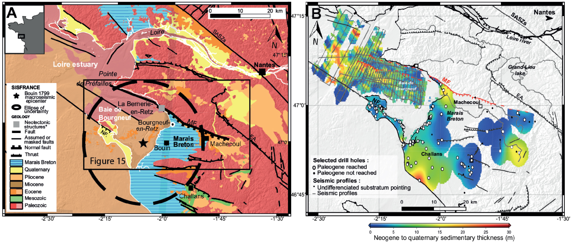
The offshore fault segment geometry and the sediment infilling in the Baie de Bourgneuf were investigated from 700 km of high-resolution low penetration offshore seismic data acquired using a single-channel (SIG) streamer and a SPARKER source, as well as a sub-bottom profiler simultaneously (Figures 14B and 15D) [Le Roy et al. 2016; Kaub et al. 2017] and high-resolution Geoswath interferometric sonar bathymetry data with a total coverage of 40 km2 (Figure 15A, B, C). Lithologic and chronostratigraphic attributions of seismic units are based on the acoustic facies variability defined in previous studies of the South-Armorican platform [e.g. Delanoë et al. 1976; Menier 2004; Huerta et al. 2010; Proust et al. 2010] to infer the Neogene to Quaternary sediment thickness. To extend the sediment infilling data set and to better constrain the basin geometry onshore along the whole Machecoul Fault, gravity data from the Bureau Gravimétrique International (BGI)1 were used (data available at http://bgi.obs-mip.fr/.), and drilling data from the French national drill-hole database (Banque du Sous-Sol—BSS available at https://infoterre.brgm.fr/page/banque-sol-bss) supplemented by geological cross-sections and/or simplified lithostratigraphic columns along the wells to infer the Neogene to Quaternary sediment thickness (Figure 14B).
[Modified after Kaub et al. 2021] (A) Morphological map of the Machecoul Fault from RGEALTI (5 m resolution) and HOMONIM (100 m resolution) and the new high-resolution bathymetric data acquired during RETZ2 cruise merged with the previous POPCORE 2016 cruise DEM [Baltzer 2016]. (B) Plots of bathymetric profiles 10 to 16 and topographic profiles 1 to 9 located on the map Figure 2A. (C) 3D view of the main high-resolution bathymetric surveyed area. (D) Seismic profile of RETZ2 cruise with a 10x vertical exaggeration. (E) View (to the north) of the scarp presumably associated with the Machecoul Fault, in the Marais Breton plain. This feature will be explored in order to identify a suitable place for paleoseismological trenching.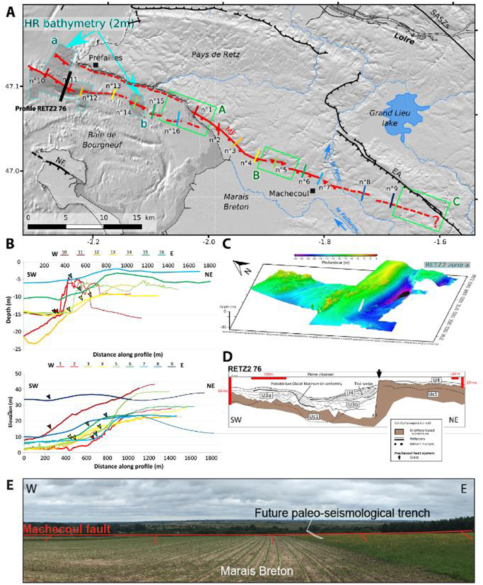
Offshore and onshore observations suggest a recent activity of the segmented Machecoul Fault bounding the basin to the north. Onshore, the topographic signature of the Machecoul Fault is very tenuous even if the escarpment is locally well expressed (Figures 15A, B and E). Its morphological trace diminishes gradually eastward with a relative fault escarpment height that varies between 28 and 7 m. Seven segments were distinguished with length ranging from 2.5 to 12.5 km (Figure 15A). On the footwall, the hydrographic network organization is generally consistent with the southward slope direction of the fault escarpment and the surrounding tectonic structures, except for the Tenu epigenic river flowing northward through the Machecoul Fault escarpment, which reflects its antecedence. Offshore, the extension of the Machecoul Fault is composed of two parallel escarpments in the vicinity of the Pointe de Préfailles (Figure 15A). The fault trace is discontinuous and sinuous, in some places strongly expressed up to the seafloor and in others no longer visible under the recent sedimentary cover. The height of the escarpment varies laterally due to spatial variations of rock roughness or marine erosion processes associated with tidal currents.
The overall sedimentary thickness deduced from a gravity modeling approach based on the BSS drill-hole data is consistent with the observed Bouguer anomaly and indicates a shallow basin depth. According to drill-hole data only, the overall thickness of onshore Plio-Quaternary deposits increases both toward the Machecoul Fault and seaward (Figure 14B). According to the seismic data, all the segments of the Machecoul fault system are southwest dipping normal faults with an apparent subsidence of the hanging wall (e.g. Figure 15D). The offshore Plio-Quaternary units infill paleovalleys and seem to increase in thickness westward (up to 25 m in the main valleys). The deposition of these units appears to be controlled by the southern escarpment of the Machecoul Fault. The planar contact between the Plio-Quaternary sediments and the basement along the fault trace as well as the thickening of these sedimentary units near this contact suggests tectonic control rather than erosion.
(A) Location of potential active faults in northern France; fault traces are from Jomard et al. [2017]. BF: Bray Fault, WBAS: Weald–Boulonnais–Artois Structure, SF: Sangatte Fault, MF: Marqueffles Fault, LHF: Lille-Hazebrouck Fault, MTA: Mélantois-Tournaisis Anticline. (B) Detailed photograph (P. Antoine) of an archeological trench at Beauvais “La Justice” along the Bray Fault (BF) showing a N090–100° E trending normal fault shifting the contact surface between the Tertiary (Thanetian) and Quaternary (Upper Pleistocene–Weichselien) (note that downward, the fault also affects the Upper Cretaceous top surface of chalk (out of frame) which evidences a neotectonic origin) [Locht et al. 1995].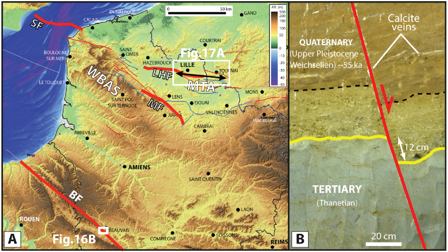
Offshore and onshore observations suggest a recent activity of the segmented Machecoul Fault bounding the basin to the north, although Holocene activity cannot be categorically demonstrated. However, these new data obtained in the framework of this study, combined with the spatial distribution of the seismicity recorded between 2011 and 2017 [Kaub et al. 2021] are consistent with this interpretation. The Kaub et al. [2021] study documents new argument suggesting that the Machecoul Fault is a serious candidate for being the likely source of the historical 1799 ∼M6 Bouin earthquake. Further studies, involving subsurface geophysics, neotectonics and paleoseismological survey (Figure 15E) are required to eventually demonstrate the relation between the fault and earthquake.
3.4.3. Faults in the northern Paris basin
Northern France presents mostly a very low level of seismic hazard with very weak and sparse historical and instrumental seismicity, slightly increasing toward the Belgium border. Among the strongest seismic events of northern France, the Ms ∼ 6, 1580 Strait of Dover earthquake [García-Moreno et al. 2015] and the Ms 5, 1896 Lens-Arras earthquake have been presumably associated with identified faults, respectively the Sangatte fault (SF) and the Marqueffles Faults (MF) [Camelbeeck et al. 2007], both segments of the Weald–Boulonnais–Artois structure (WBAS) [e.g. Minguely 2007]. Geological evidence of past large surface-rupturing earthquakes are fairly rare all over the Paris basin, where large basement faults propagate from deep Paleozoic structures to the Mesozoic and Cenozoic formations [Minguely 2007; Van Vliet-Lanoë et al. 2000]. Sheared Quaternary fossils in the archaeological site of Biache-Saint-Vaast, nearby the MF, are interpreted to document mid-to-late Pleistocene tectonic deformation [Colbeaux et al. 1981]. Further south, near the city of Beauvais, archeological trenches have exhumed a clear evidence of faulting in the Cretaceous and Thanetian layers and the Quaternary–Upper Pleistocene aeolian sands, in the vicinity of the Bray fault and a related surface anticline (Figure 16).
In order to document the paleosismological activity of regional faults, Camelbeeck et al. [2012] started first to perform geophysical surveys to match morphological features with potential fault at shallow depth. A series of electrical profiles were, for instance, carried out along the MF, but results remained unfortunately unclear, and could neither confirm a Quaternary activity nor identify a suitable site for paleosismological trenching. Recently, Znidarsic [2021] performed a geomorphological investigation along the Lille-Hazebrouck (or Haubourdin) Fault (LHF), a potentially active fault [Jomard et al. 2017]. This fault strikes roughly parallel to the E–W open Mélantois-Tournaisis anticline that folds the Upper Cretaceous chalk and the underlying Paleozoic basement [Hennebert 1998].
(A) Digital Elevation Model from airborne LiDAR along the Lille-Hazebrouck Fault (see Figure 16) at the hinge of the Mélantois-Tournaisis Anticline (MTA) (data source: IGN-RGE-Alti for France and SPW for Belgium). A several meter WNW–ESE trending topographic scarp is clearly visible between Haubourdin and Lesquin. (B) 1.5 m high topographic scarp observed at Wannehain, corresponding to the eastwards extension of the MTA (B). (C) Catchments with headward erosion features suggesting a recent incision resumption due to local surface uplift (these features are located along the presumably extension of the LHF in Belgium).
The LHF is a sub-vertical ∼50-km-long fault striking N100° E, few kilometers south of the Lille urban area (Figures 16A, 17A). Its recent activity is suggested by a change in Quaternary fluvial deposits thickness of the Deûle river [Sommé 1977; Waterlot 1960]. Moreover, the high-resolution DEM from several LiDAR surveys in France MEL (2018),2 IGN (2015)3 and Belgium SPW (2014)4 suggests a morphological signature that could be associated to a recent activity within its eastward extension toward Belgium (Tournai or Rûmes Fault; https://bdfa.irsn.fr/). On the French side, striking features consist in two topographic scarps, with several meters of throw in the Haubourdin–Lesquin region, and by a 1.5 m topographic scarp in the eastern Wannehain region (Figure 17B). On the Belgian side, near the Guignies city, two peculiar drainage anomalies with remarkable evidences of headward erosion are observed (Figure 17C). These features could suggest a recent uplift along the fault system. Data from the French national drill-hole database (BRGM,5 Banque du Sous-Sol) confirm the position of the fault on the French side but does not help to clarify whether the above mentioned scarps are controlled by inherited lithological effects or by active faulting.
The next step will be to characterize the subsurface geology with non-penetrative geophysical methods and identify sites for trenching. Preliminary investigations have been carried out to document the subsurface geometry of the Wannehain scarp, thanks to a series of ground-penetrating radar (GPR) profiles. Unfortunately, GPR results have not yet allowed the identification of a clear near-surface fault signal. Meanwhile, both topographic and geophysical results are integrated in a 3D geological model of the Mélantois Anticline. This model is built gradually with the MOVE software, from boreholes and geophysical datasets, in collaboration with the French Geological Survey (BRGM) and the Lille European Metropolis administration [Graveleau et al. 2018]. This work will contribute to characterize and potentially relocate the LHF and its likely connection with the Tournai Fault.
Further neotectonic studies are therefore necessary in the Hauts-de-France region to document potential active faults. Particularly, prospective subsurface geophysical surveys followed by paleoseismologic trenching appear necessary to evidence relationships between regional faults, neoteotectonic deformation and earthquake sources. In addition, in the context of northern France, which has been subject to important Quaternary glacial/periglacial morphogenetic processes, it is important to improve our ability to decipher the origin of surface deformation features, either linked to glacial phenomena or to seismic events.
4. Discussion and conclusions
In this contribution, we have emphasized some basic results and highlighted several clues, methods and strategies that are currently under development to characterize active faults in mainland France. These investigations involve new and innovative techniques as well as classical approaches, and mobilize earth scientists from various fields of expertise (geologists, geophysicists, geomorphologists, earthquake geologists).
4.1. Toward a contribution to the quantification of fault activity
The examples presented here cover a large panel of settings, and illustrate that the tectonic context in the different French regions affected by earthquakes is complex, and probably controlled by several different geodynamic processes as summarized by Mazzotti et al. [2020] and developed in references therein. These processes comprise long-term and large-scale tectonics including the African–Eurasian convergence, the counter-clockwise rotation of the Adria microplate [e.g. Eva et al. 2020; Mathey et al. 2021], the Atlantic ridge push [Gölke and Coblentz 1996], the isostatic motions related to local or regional internal and/or external phenomena [e.g. Sternai et al. 2019; Malcles et al. 2020], the stresses caused by Gravitational Potential Energy [Camelbeeck et al. 2013] and/or transient processes [e.g. Grasso et al. 1992]. The understanding of “faults” in a conceptual framework is then difficult and the classical scheme established for fast faults with a tectonic loading governing a seismic cycle probably becomes unsuitable in the state of knowledge [Calais et al. 2016]. Seismic hazard calculation models will however undoubtedly benefit from a better characterization of active faults. Determining fault geometry at the surface (length, segmentation) and at depth (width, dip angle) with geological and geophysical data, estimating the fault kinematics with seismological or paleoseismological data, or assessing their slip rates with geodetical or geological information, are the keys to convert those faults into potential earthquake sources for seismic hazard models. Such geological information are necessary to define fault models through their related magnitude-frequency distribution of seismicity, including in slowly deforming regions [e.g. Clément et al. 2004; Chartier et al. 2017; Gómez-Novell et al. 2020; Valentini et al. 2020].
4.2. Unclamping the caveats
To pursue the effort already engaged (see the foregoing sections) with a good chance of success, some caveats must be taken into account and the recent studies’ background helps a lot in understanding how to overcome them.
First, and echoing the previous sections, we emphasize that the cases analyzed had been explored with success by the following appropriate strategies depending on the setting, sometimes favoring the geology of superficial formations (e.g., trenches), sometimes subsurface geophysics, sometimes tectonic geomorphology, or even the use of advanced seismological data. The feedback of the La Rouvière Fault study near Le Teil (see above) has reminded to us, trained earthquake-geologists, that fault activity could be recorded as well in a priori unsuitable settings, such as slopes in hilly and covered regions. This underlines the potentiality and relevance of “classical” geological and paleosismological investigations, and the necessity to include them in the first stages of investigations. However, we stress that the intraplate context of low deformation makes it necessary to conduct multidisciplinary research to describe the geological features at various temporal—while remaining in the Quaternary period limit—and spatial scales, and to discuss the potential controls on the apparent deformation, whatever they are external or internal processes. Such studies should involve complementarity of the invested researchers.
Concretely, some technical means are also crucial to move forward. The acquisition or provision of a very high-resolution DEM appears necessary to detect potential morphotectonic signatures of fault activity, small surface deformations and a good visualization of the terrain that precedes any investigation on surface formations. For instance, the availability of the LiDAR DEM of Baden-Würtemberg (Germany) or in Provence enabled imaging of potential deformation markers prior to trenching [e.g. Thomas 2018; Reicherter et al. 2021].
InSAR is also now widely used to access the slow ground displacements at regional scales, and the results could be particularly relevant in neotectonics and fault study because of their spatial coverage which drastically complete the GNSS velocity fields [e.g. Berthelon et al. 2019; Mathey 2020].
Several dating methods (e.g. in situ-produced cosmogenic radionuclides, OSL, ESR, 14C) now allow to date almost all types of material/deposits (quartz, carbonates, volcanic, detrital, organic, etc.) exposed in surface or buried, and to (almost) all Quaternary time scales: this could allow reaching time constraints unequaled until today. Thus, we can quickly revisit the shortcomings of dating associated to known deformation markers, among them undated potential paleoseismic events [e.g. see the Trévaresse Fault trenches: [Chardon et al. 2005]; the Courthézon trench deposits: Carbon et al. 1993] or fault mirrors [e.g. Vignaroli et al. 2020].
High-resolution geophysical subsurface prospecting techniques will be beneficial, including georadar [e.g. McClymont et al. 2008], electric tomography [e.g. Nguyen et al. 2007; Villani and Sapia 2017], seismic reflection in S waves [e.g. Wang et al. 2021]. Such techniques will help in locating faults below the Quaternary deposits (see the example of the Marsanne fault above). Within the offshore region of mainland France, active faults can be investigated thanks to appropriate techniques such as multi-channel seismic reflection and multibeam bathymetry, and Remotely Operated Vehicles) [e.g. Escartín et al. 2016, and the Ligurian fault system presented above].
4.3. Further studies strategy
The strategy of targeting the epicentral area of large historical earthquakes as an indicator of the seismic activity of active geological structures and as a guide to studying them has proved to be successful in most cases. However, it has also shown its own limits with the occurrence of the Le Teil earthquake, relatively far from any significant historical epicentral area. The occurrence of this earthquake in 2019 also revealed the gaps in our knowledge on the active faults: the source fault (La Rouvière fault) is now proved to have been responsible for tectonic deformations during the Pleistocene–Holocene [Ritz et al. 2021], while it was missing from any study in the literature and hence in the BDFA [Jomard et al. 2017].
How can we proceed in order to improve our state of knowledge? The first option can be to continue on the “track of the historical earthquake”, investigating the faults in their immediate vicinity. However, given the long recurrence intervals of earthquakes, we also need extending beyond, by targeting the inherited structures longer than 5 km with either a morphological signature, or limiting Plio-Quaternary sedimentary basins. The target areas could still be very wide in Mainland France and one could suggest piloting studies by societal issues such as proximity to populated areas, environmentally hazardous facilities, or strategic areas for communications, transport of essential resources, etc. Anyway, defining targets, as well as implementing complementary approaches, implies close collaboration between academic researchers, with their thematic knowledge, institutional scientists, with their regional and regulatory knowledge, and finally industry/stakeholders, with their prioritization of the facilities to be protected.
The FACT group within the ATS consortium action [Masson et al. 2021] has been exactly built in the perspective of rendering the active fault studies efficient, gathering the national scientific community to define the priority targets, propose the best technical and scientific strategies and tools, and discuss the results and their interpretation, and build up the most complete possible database of active faults for the Quaternary period. It gathers volunteer earthquake geologists, who are involved in fieldworks in nine regions of mainland France, with one or two points of contact per region. Those are in charge of coordinating a reassessment of the existing databases, and of the launching of new investigations with the appropriate methods. A close collaboration with neighboring countries (Belgium, Germany, Italy, and Spain) has been established to cover the transnational geological objects and themes.
Conflicts of interest
Authors have no conflict of interest to declare.
Author contributions
JFR, SB: conception and design of the work, writing of the Introduction (1), State-of-the-art (2) and Discussion sections (4), and homogenization of the Regional sections; acquisition, analysis and interpretation of data; conception of figures.
LA, CA, FG, CK, PL, CL, FL, KM, JLM, MO, MR, RV: writing of the Regional sections (3); drafting the text and revising it critically; acquisition, analysis and interpretation of data; conception of figures.
PAn, PAr, JB, LB, MF, CF, LG, HJ, PLR, JLL, SM, CP, JP, GR, KR, OS, CV, MVM, JVDW: revising the text; participating in acquisition, analysis and interpretation of data and/or to the FACT working group.
Acknowledgments
We thank the Transverse Seismicity Action (ATS) of the Resif-Epos Consortium for its support to the “Failles ACTives France” (FACT) axis, and the INSU-Tellus program for funding several research projects (e.g. The morphotectonic and paleoseismological investigations along the CFS, following the Le Teil, 11-11-2019 earthquake, and the ongoing studies along the Vallorcine and the Trevaresse faults). The FACT axis Region 1 (Cevennes) acknowledges also the IRSN and the CEA for their support during the paleoseismological investigations along the La Rouvière Fault. SB and HJ field work and projects were funded by IRSN. LB work was funded by the CEA. JFR, SB and LA thank also V. Godard, E. Beucler, Y. Gaudemer, M. Meghraoui, for their help and their implication in the management of the FACT axis at the regional scale. RV and JLM thank F. Berger and J.-M. Monnet (INRAe Grenoble) for granting them the use of their Chamonix LiDAR data. FL thanks the Flotte océanographique française and Ifremer for its support during the TELEPRESENCE project, and the captain and crew of the R/V L’Europe. Géoazur participation was supported by the RiTMICA project (Risques Telluriques Multiples, Intégrés, sur la Côte d’Azur—granted by IDEX UCAJedi). We also thank two anonymous reviewers whose comments and corrections helped improve a first version of the manuscript.
1BGI. Bureau Gravimétrique International. Data available at http://bgi.obs-mip.fr/.
2MEL (2018). Modèle Numérique de Terrain (MNT LiDAR). Available at https://webimaging.lillemetropole.fr/externe/lidar/2018_scot/raster/MNT/.
3IGN (2015). RGE Alti®. Available at https://www.geoportail.gouv.fr/donnees/rge-alti-sources.
4SPW (2014). Modèle Numérique de Terrai (MNT LiDAR). Available at https://geoportail.wallonie.be/catalogue/6029e738-f828-438b-b10a-85e67f77af92.html.
5BRGM. Bureau de Recherches Géologiques et Minières. Banque de données du sous-sol (BSS), available at http://infoterre.brgm.fr/page/banque-sol-bss.