

Version française abrégée
1 Introduction
Le Sud–Ouest de Taiwan est une région-clé où les structures de la collision arc-continent de Taiwan empiètent sur la marge continentale passive chinoise. Le front de déformation qui limite en mer, à l'ouest, les structures du prisme d'accrétion sédimentaire de Manille passe au pied de la pente continentale, adopte une direction nord–est au niveau du plateau continental de Kaoping et se connecte à la faille de Tainan, le chevauchement frontal des piémonts sud–occidentaux de l'orogène de Taiwan [6,17,21], Fig. 1A.
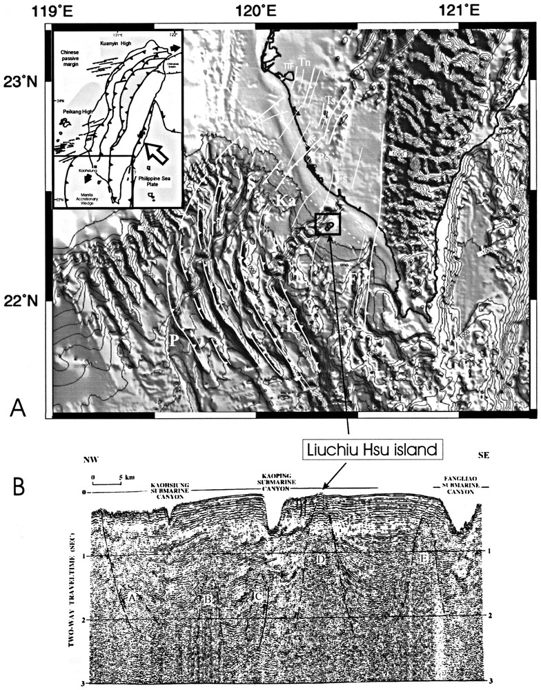
(A) Shaded bathymetric map and main morphological/structural features of SW Taiwan (after Liu et al. [22]). Depth contours in 200 m interval. Heavy lines with triangles are thrusts (TTF: Tainan Thrust Fault; MTF: Meilin Thrust Fault), associated thinner lines are related anticline axes. Canyons labelled as: K: Kaoping, Ka: Kaohsiung, P: Penghu, S: Shoushan, F: Fengliao. Anticlines: Tn: Tainan, C: Chungchou, Ts: Takangshan, Ps: Panpingshan, Fs: Fengshan. (B) NW–SE seismic profile showing mud diapirs and related anticlines. Location on the bathymetric map. Anticline labelled A on the seismic profile is correlated with the Panpingshan anticline on-land Taiwan. Anticline labelled D on the seismic profile is the Liuchiu Hsu anticline. Modified after Liu et al. [21].
(A) Carte bathymétrique ombrée et principales structures morphologiques dans le Sud–Ouest de Taiwan (d'après Liu et al. [22]). Isobathes : intervalle de 200 m. Traits épais avec triangles : principaux chevauchements (TTF : chevauchement de Tainan ; MTF : chevauchement de Mailin), lignes plus fines associées : axes anticlinaux. Canyons : K : Kaoping, Ka : Kaohsiung, P : Penghu, S : Shoushan, F : Fengliao. Anticlinaux à terre : Tn : Tainan, C : Chungchou, Ts : Takangshan, Ps : Panpingshan, Fs : Fengshan. (B) Profil sismique NW–SE montrant les diapirs de boue et les anticlinaux associés (localisation sur la carte bathymétrique). L'anticlinal marqué A sur le profil est corrélé avec l'anticlinal de Panpingshan à terre. L'anticlinal marqué D sur le profil est l'anticlinal de Liuchiu Hsu. Modifié d'après Liu et al. [22].
D'un point de vue morphologique, les reliefs dominants en mer sont des rides orientées NNW–SSE qui tournent dans une direction NNE–SSW près de la pente continentale de la Mer de Chine du Sud et s'enfouissent sous les sédiments du plateau continental de Kaoping. D'un point de vue structural, ces rides constituent le prolongement des structures chevauchantes du prisme d'accrétion de Manille et se connectent, au nord, aux chevauchements du Sud–Ouest de Taiwan (Fig. 1A). D'importants canyons sous-marins entaillent le plateau continental, comme les canyons de Kaoping, Fengliao, Kaohsiung, Penghu et Shoushan (Fig. 1A), dont la plupart sont liés à une érosion sous-marine guidée par les structures compressives [21,30].
L'ı̂le de Liuchiu, située à proximité immédiate des côtes de Taiwan, a une surface de 10 km2. Sa formation a été récemment attribuée à l'émersion d'un diapir de boue [21], dont les terrains surincombants ont été érodés par le paléo-canyon de Kaoping [5].
L'objet de cette Note est de reconstituer l'évolution tectonique de l'ı̂le à partir d'observations de terrain, de la comparer à celle des structures à terre et de discuter l'hypothèse « diapir » pour la genèse de l'ı̂le.
2 Contexte sédimentaire et structural
Pendant le Pliocène–Pléistocène, les environnements de dépôts dans le Sud–Ouest de Taiwan ont évolué de marin profond, avec d'importants dépôts de boues argileuses et de silts en provenance de l'orogène, à marin peu profond, puis deltaı̈que ; la tectonique compressive combinée à la surcharge sédimentaire a provoqué un diapirisme de boue dans ce secteur.
Les diapirs de boue sont aisément reconnaissables en sismique-réflexion par leur signature acoustique « amorphe ». Certains sont parvenus à la surface, ce qui suggère qu'ils sont encore actifs [4]. Beaucoup d'entre eux sont remontés vers la surface le long de chevauchements (Fig. 1B).
L'ı̂le de Liuchiu est installée au sommet d'un de ces diapirs (Fig. 1B) ; elle est composée essentiellement de mudstones pliocènes recouverts en discordance par 4–10 m de calcaires récifaux pléistocènes [3,13].
3 Méthodes d'analyse tectonique
Malgré le peu d'affleurements dans l'ı̂le, nous avons effectué une analyse de la fracturation (failles à stries, fentes d'extension) et une reconstitution des paléocontraintes fondée sur la méthode maintenant classique d'inversion des données de failles [1]. On déduit le tenseur réduit des contraintes, c'est-à-dire l'orientation des axes principaux de contraintes σ1, σ2, et σ3 (σ1⩾σ2⩾σ3, pressions positives) et le rapport Φ, Φ=(σ2−σ3)/(σ1−σ3).
Les calcaires pléistocènes de Taiwan fournissent également un matériau favorable à la reconstitution des paléocontraintes fondée sur l'inversion des données de macles de la calcite [15,26], qui conduit également au tenseur réduit des contraintes. Ces calcaires contiennent de gros cristaux de calcite sparitique d'orientation quelconque ; les lamelles de macles fines et rectilignes indiquent une déformation faible (moins de 2 %) et de basse température (<200 °C). Un échantillon de calcaire a été analysé le long de la côte nord de Liuchiu Hsu, où aucun affleurement ne permet l'observation de fractures.
4 Résultats : analyse des fractures et reconstruction des paléocontraintes dans l'ı̂le de Liuchiu Hsu
La structure de l'ı̂le est dominée par un anticlinal d'axe N040° (Fig. 2A).

(A) Structural map of Liuchiu island. 1. Pleistocene reef limestones; 2. Pliocene mudstones; 3. Holocene reefs; 4. Gravels; 5. Submarine part of Liuchiu Hsu mud diapir; 6. Anticline axis; 7. Shallow normal faults around Liuchiu Hsu (Chow et al. [5]). Fault-slip data: thin curves represent fault planes and dots with double arrows (left- or right-lateral) or simple ones (centripetal-reverse/centrifugal-normal) indicate striations. Stars indicate stress axes with five points (σ1), four points (σ2) and three points (σ3). Equal area projection. Planes without striations represent extension fractures. Large black arrows: Direction of compression (convergent arrows) and extension (divergent arrows); Dashed lines represent bedding. Stress axes on smaller diagrams are determined from calcite twin data. (B) Schematic tectonic evolution of the Liuchiu Hsu island, in section and map-view.
(A) Carte structurale de l'ı̂le de Liuchiu. 1. Calcaires récifaux pléistocènes ; 2. Mudstones pliocènes ; 3. Récifs holocènes ; 4. Graviers ; 5. Partie sous-marine du diapir de Liuchiu Hsu ; 6. Axe anticlinal ; 7. Failles normales superficielles autour de Liuchiu Hsu [5]. Données de failles : traces cyclographiques des plans avec les stries correspondantes, Projection de Schmidt, hémisphère inférieur. Les étoiles à 5 branches indiquent σ1, 4 branches σ2 et 3 branches σ3. Les plans sans strie correspondent aux fractures en extension. Flèches noires : Direction de compression/extension ; Tiretés : plan de stratification. Les axes de contrainte reportés sur les petits diagrammes sont déterminés par les macles de la calcite. (B) Evolution tectonique schématique de l'ı̂le de Liuchiu Hsu, en carte et en coupe.
Deux grands types de fracturation ont été identifiés, qui diffèrent selon la lithologie. Dans les mudstones pliocènes, on observe, soit des décrochements et des failles inverses compatibles avec une compression NW–SE, soit des failles normales compatibles avec une extension radiale (Fig. 2A), ce que confirment les faibles valeurs du rapport Φ. Les chronologies entre ces systèmes de fractures semblent incompatibles, ce qui pourrait refléter une alternance au cours du temps. Les autres fractures, uniquement observées dans les calcaires, sont des fentes d'extension à cristallisations de calcite, d'orientations variables d'un site à l'autre. L'inversion des données de macles de la calcite dans l'échantillon de calcaire de la côte nord indique une compression NW–SE et une extension parallèle [25].
5 Discussion
Evolution tectonique de l'ı̂le de Liuchiu Hsu
Nous interprétons la compression NW–SE comme liée au raccourcissement orogénique plio-pléistocène. Cette compression, bien connue à terre, a alterné avec une extension radiale locale liée au développement de l'ı̂le à l'apex d'un diapir de boue. Les récifs pléistocènes se sont développés au sommet de ce point haut où l'influx détritique était moindre. Pendant le Pléistocène, la compression NW–SE a accentué la structure anticlinale, puis un ploiement général de l'ı̂le probablement lié à un soubressaut tardif de remontée diapirique a engendré une extension radiale, réouvrant toutes les fractures formées lors du serrage NW–SE (Fig. 2A).
Comparaison avec les structures à terre
Les profils sismiques montrent que les structures chevauchantes et les anticlinaux associés se poursuivent à terre par les chevauchements et les plis connus dans les piémonts méridionaux, ce qui suggère que la zone transformante de Kaohsiung (KTFZ [6]), si elle existe [17], n'est associée qu'à un décalage très faible ou local des structures. L'anticlinal dissymétrique de Panpingshan est un de ces plis associés à des chevauchements à vergence ouest, coiffé par des calcaires récifaux pléistocènes interstratifiés dans les mudstones (e.g., [2,8]) et du même âge que les calcaires de Liuchiu Hsu. Gong et al. [7] et Lacombe et al. [16,17] ont proposé que ces calcaires se soient développés au sommet de hauts structuraux, un scénario qui peut s'appliquer aux récifs de Liuchiu Hsu formés au sommet d'un diapir dont la remontée est contrôlée par la tectonique. La reconstitution de paléocontraintes, dans ce pli comme dans celui de Takangshan, a conduit à une compression NW–SE suivie d'une compression est–ouest [15,16,26], et à une compression WNW–ESE dans l'anticlinal de Fengshan [17].
L'évolution tectonique de Liuchiu Hsu est donc, sur quelques points, similaire à celle des structures à terre (compression NW–SE), mais en diffère en ce sens que la compression est–ouest récente, interprétée comme la signature du début de l'échappement pléistocène dans le Sud–Ouest de Taiwan [18] n'a apparemment pas affecté l'ı̂le ; son histoire plio-pléistocène a plutôt été dominée par la remontée d'un diapir de boue entraı̂nant une extension radiale locale, contemporaine du raccourcissement orogénique NW–SE.
Les anticlinaux dans le Sud–Ouest de Taiwan : tectonique ou diapirisme ?
Les diapirs de boue au large de Taiwan apparaissent comme des rides allongées de direction NNE–SSW parallèles aux plis, chevauchements et alignements de diapirs observés à terre. Le diapirisme de boue a été expliqué par le déséquilibre causé par le dépôt rapide et préférentiel de sédiments terrigènes dans les synclinaux, les chevauchements le long des diapirs (Fig. 1B) apparaissant, d'abord en réponse au raccourcissement, puis en relation avec le diapirisme [21]. Une origine diapirique a également été proposée pour les anticlinaux de Tainan, Chungchou, Panpingshan et Fengshan du Sud–Ouest de Taiwan [12,14,24,29].
Comme déjà discuté par Lacombe et al. [17], un moteur purement diapirique ne peut cependant pas rendre compte de la dissymétrie des anticlinaux et du caractère allongé des rides, plus en accord avec une genèse contrôlée tectoniquement par des chevauchements. La cohérence régionale des directions de compression reconstituées à terre et en mer (Liuchiu) suggère que le moteur principal soit tectonique. Nous proposons que les plis du Sud–Ouest de Taiwan à terre comme en mer, s'initient en relation avec des chevauchements à vergence ouest, les contacts tectoniques et le décollement basal guidant la circulation et l'émergence des fluides, comme cela est connu dans d'autres zones de subduction (e.g., La Barbade [11,20], ou le prisme d'accrétion de Nankai [10]). Le diapirisme s'amorce alors par la remontée des boues saturées de fluides en réponse au raccourcissement, et est stimulé par le dépôt rapide au niveau des synclinaux d'importantes épaisseurs de sédiments terrigènes sur ces boues épaisses et peu consolidées.
1 Introduction
The area off southwestern Taiwan is the place where the arc-continent collision zone encroaches the Chinese passive continental margin. The deformation front separates the fold-and-thrust structures of the convergent zone and the horst-and-graben structures of the passive margin; it extends from the eastern edge of the Manila Trench and Penghu Canyon NNW – ward to the foot of the continental slope, then turns northeast-ward across the continental slope and the Kaoping Shelf, and connects to the frontal thrust of the Taiwan mountain belt, the Tainan fault (TTF) [6,17,21]; Fig. 1A.
Major morphological features in the Kaoping Slope region are the NNW–SSE trending ridges which turn into a NNE–SSW direction near the South China Sea slope and are then buried by the Kaoping Shelf sediments. Structurally, these ridges are the northward extension of the ramp anticlines formed by mostly west-vergent thrusts in the frontal portion of the Manila accretionary wedge [21]. These ridges connect to the north to the fold-and-thrust belt of the Western Foothills on land Taiwan (Fig. 1A).
Several submarine canyons cut across the Kaoping Shelf mainly in a NE–SW direction, which include the Kaoping, Fengliao, Kaohsiung, Penghu and Shoushan canyons (Fig. 1A). These canyons generally result from a fault-controlled submarine erosion, well documented for the Penghu Canyon or the Shoushan Canyon [21,30].
The Liuchiu Hsu island is located off the southwestern coast of Taiwan, next to the Kaoping canyon (Fig. 1A). Its NE–SW axis is about 5 km long, and its maximum width in the NW–SE direction is 3 km. The total area above sea level is about 10 km2. The formation of the island has been recently related to the emergence above sea level of a mud diapir [21], the erosion of the overlying sedimentary layers by the Kaoping paleo-canyon allowing the diapir to rise up to the sea floor in response to the reduction of its overburden [5].
A diapiric origin has also been proposed for the on-land anticlines trending NE–SW in southwestern Taiwan (e.g., Huang [14]). However, as discussed by Lacombe et al. [17], a model of fold development mainly driven by mud diapirism does not account for the general asymmetry of the west-vergent anticlines, since mud diapirism usually results in more symmetric features. Offshore, the elongated character of the ridges formed by diapir alignments also argues in favour of a tectonic origin with initiation along northeast trending thrusts. The Liuchiu Hsu island is therefore a key place to collect new tectonic data and to test the previously proposed models. In addition, this place has never given rise to microtectonic data although it makes a useful bridge between on-land and offshore observations.
The aim of this paper is to investigate the tectonic evolution of the island, based on field observation. New tectonic data were collected in order to discriminate between a structural evolution, mainly driven by mud diapirism, from that also controlled by orogenic forces. As a result, we compare the tectonic histories of on-land and offshore structures and provide an alternate interpretation to the previously proposed model of mud diapirism for Liuchiu Hsu island formation.
2 Sedimentary and structural setting
In the Early Pliocene, the paleoenvironment of the offshore area of southwestern Taiwan was deep marine. Large amounts of mud and silt derived from the orogen were deposited during that time, and in the Pliocene–Pleistocene, a thick fine-grained sediment sequence was deposited and folded. In response to the arc-continent collision, the depositional environment in this area evolved into shallow marine and deltaic, and the compressive tectonic forces of this still-active collision, together with the unbalanced sediment load, combined to trigger mud diapirism in this region.
In the offshore Tainan–Kaohsiung–Hengchun area, fold-and-thrust structures are buried beneath thick sedimentary strata. Diapirs are the most prominent features on the seismic profiles since they can be easily identified by their acoustically amorphous character (Fig. 1B). Most of the diapirs are also buried beneath young sediments, but some have pierced through the very young sedimentary cover and become exposed on the sea floor, suggesting that they are still active (Chow et al. [4]). Seismic profiles show that many mud diapirs have moved up along thrust faults which may not extend upward to the sea floor (Fig. 1B) because of the rapid deposition of terrigenous sediments.
The Liuchiu Hsu island is located on one of these diapirs that has been raised above the sea surface; it is composed of Pliocene gray mudstones unconformably overlain by a 4–10 m thickness of Pleistocene reef limestones [3,13].
3 Methods of tectonic analysis
Because of the absence of visible macrostructures, we carried out a detailed study of small-scale brittle deformation, such as striated fault surfaces and extension fractures. The location of sites is reported in Fig. 2A. The dynamic interpretation of these microstructures, in terms of stress patterns, brought constraints on both the Plio-Quaternary tectonic mechanisms and the kinematics of tectonic units.
Computation of paleostress tensors was mainly performed on the basis of inversion of fault slip data (Angelier [1]). The basic principle consists of finding the best fit between the observed directions and senses of slip on numerous faults and the theoretical shear stress induced on these planes by the tensor solution of the inverse problem. The analysis leads to the reduced stress tensor (orientation of the three principal stress axes σ1, σ2, and σ3 (σ1⩾σ2⩾σ3, pression considered positive and the Φ ratio, Φ=(σ2−σ3)/(σ1−σ3)). Additional information is obtained from extension fractures. The procedure for separating successive stress tensors and related subsets of fault slip data is based on both the mechanical reasoning (e.g., [1]) and the relative tectonic chronology data (especially, superimposed striations on fault surfaces or crosscutting relationships between faults).
The Pleistocene reef limestones in Taiwan also proved to be a suitable material for paleostress reconstructions based on inversion of mechanical twins in calcite [15,26], which also leads to the reduced stress tensor. They contain large sparry calcite crystals displaying nearly homogeneous size and nearly random crystallographic orientations; these crystals result from the diagenetic recrystallization of primary aragonitic material and micritic calcite. Twin lamellae within these grains are straight and narrow, indicating low strain (less than 2 or 3%) and low temperature (<200 °C). A limestone sample collected on the northern coast of Liuchiu Hsu where no outcrop allowed observation of fracture or fault (Rocher [25]) was therefore analysed.
4 Results: fracture analysis and paleostress reconstructions in the Liuchiu Hsu island
The Liuchiu Hsu island is dominated by an anticline structure with a N040° axis (Fig. 2A). However, the scarcity of outcrops together with the poor record of faulting by the Pleistocene reef limestones and the difficulty to identify senses of slips on fault surfaces in the mudstones explain the absence of previous tectonic investigations and the few data which could be collected during fieldwork.
Two main types of fractures have been observed, depending on the lithology. The first one was observed in Pliocene mudstones and consists of minor striated faults with offsets of few centimeters. Some of these faults are nearly east–west trending reverse faults (site 6) or subvertical conjugate sets of north–south to N020° trending sinistral and N100° to 130° trending dextral strike-slip faults (site 3), both consistent with a NW–SE compression (Fig. 2A). The others are normal faults with dips ranging between 50 and 75° and with various orientations (sites 1 and 3). Despite the small number of data, the various trends of these normal faults strongly suggests omni-directional faulting; the Φ ratios computed from these sets of normal faults (Table 1) are close to 0, which argues in favor of nearly radial extension. In the mudstones, unconsistent relative chronology criteria between strike-slip faults and normal faults (superimposition of striations suggesting that normal movements postdate strike-slip movements but normal-type dips of strike-slip fault planes) support that compression probably alternated with extension (Fig. 2B).
Results of stress tensor determination based on fault slip/calcite twin data
Résultats de la détermination des tenseurs de contrainte fondée sur l'analyse des failles à stries et des macles de la calcite
| Site | Diagram | Trend (Plunge) of the principal stress axes | Ratio between differential stresses (Φ) | Number of data F, F′, T/UT | Quality of tensor (Q) | ||
| σ 1 | σ 2 | σ 3 | |||||
| 1 | 179 (61) | 049 (20) | 311 (20) | 0.0 | 5F | c | |
| 2 | A | 158 (31) | 295 (50) | 054 (22) | 0.1 | 42/13T/UT | a |
| B | 341 (62) | 228 (12) | 133 (25) | 0.4 | 24/13T/UT | b | |
| 3 | A | 156 (11) | 260 (49) | 057 (39) | 0.0 | 16F | b |
| B | 096 (76) | 343 (06) | 251 (12) | 0.1 | 14F | a | |
| 4 | – | – | – | – | 12F′ | – | |
| 5 | – | – | – | – | 10F′ | – | |
| 6 | 321 (09) | 052 (02) | 154 (81) | 0.5 | 13F | b | |
| 7 | – | – | – | – | 11F′ | – | |
| 8 | – | – | – | – | 40F′ | – |
The second type of fractures consists of subvertical extension fractures filled with calcite locally associated with highly dipping planes displaying evidence of normal and strike-slip movements (sites 4 and 8). Such fractures are observed only in Pleistocene limestones and display various orientations, from north–south in the south (site 8), NW–SE on the eastern coast (site 5) and east–west along the western coast (site 7) (Fig. 2A). The inversion of calcite twin data from the limestone sample collected along the northern coast indicates a NW–SE compression and a subparallel extension [25].
5 Discussion
5.1 Interpretation of results: tectonic evolution of the Liuchiu Hsu island
We interpret the consistent NW–SE to NNW–SSE compression at high angle to the mid-island anticline axis in the mudstones as the signature of the Plio-Pleistocene shortening. The radial character of the extension identified in sites 1 and 3 is supported by the omnidirectional character of normal faulting and the related very low computed Φ ratios (Table 1). Furthermore, this radial extension is local and linked to the development of the island at the apex of an uprising mud diapir; it well accounts for the pattern of larger shallow normal faults located below sea level around the Liuchiu Hsu mud volcano (Fig. 2A). These faults presumably developed in response to differential loading forces arising from the rise of the diapir and the subsidence of the surrounding regions from where the diapir is fed [5].
Pleistocene reefs then developed on top of the high created by the uprising diapir where decreasing clastic flow induced local favorable paleoecological environment for reef-building organisms. During the Late Pleistocene, the NW–SE compression was still prevailing as revealed by twinning analysis in limestones, and the anticline structure of the island was emphasized; in response to this compression, NW–SE fractures mainly formed as extension fractures, while north–south and east–west fractures presumably partly developed as shear fractures. The late general opening of all these fractures indicated by their calcite infill and the extension identified from twinning are also consistent with a radial extension linked to a diapir-related late doming of the island which led to the quadrant-like distribution of reef outcrops (Fig. 2A).
Superimposition of NW–SE compression and radial extension with unconsistent chronology in Pliocene mudstones of site 3, as well as recognition of NW–SE compression from calcite twins in the Pleistocene limestones, as well as late general extensional opening of preexisting fractures with various orientations, indicate that compression and radial extension presumably alternated during the Pliocene and the Pleistocene. As a result, we propose a Plio–Pleistocene tectonic history dominated by alternating phases of dominant NW–SE to NNW–SSE shortening and of dominant uprise of mud diapir, resulting in local radial extension.
5.2 Comparison with onshore structures
Seismic profiles show that NNE–SSW trending fold-and-thrust structures observed in the Western Foothills on-land Taiwan extend almost continuously to the offshore region underneath the thick Coastal Plain and Kaoping shelf sediments. For example, the west-vergent thrust fault labelled A on the profile of Fig. 1B (modified after Liu et al. [21]) which extends to the sea floor, can be structurally correlated to a major thrust fault that bounds the Panpingshan anticline in the Kaohsiung area, the Meilin fault (MTF, Fig. 1A). This suggests that the Kahsiung Transfer Fault Zone (Deffontaines et al. [6]), if it exists (Lacombe et al. [17]), is associated with a very small or local offset of thrusts and fold axes.
The Panpingshan anticline (Fig. 1A) provides a good example of fault-propagation folds commonly observed in southwestern Taiwan. Its steeply dipping northwestern flank is limited by the northwestern vergent Meilin thrust fault, whereas its eastern flank dips gently to the southeast. The top of this anticline is covered by thick Pleistocene reefal limestones interbedded within the clastic layers of the Gutingkeng Formation [2,8], similar to the reef limestones of the Liuchiu Hsu island. Gong et al. [7] and Lacombe et al. [15,16] have proposed that on-land Pleistocene reefs developed on structural highs raised by folding, the relative topographic high isolating them from the clastic influxes from the orogen: according to this model, reefs developed on top of folds related to west-vergent thrusts until they reached the sea level and emerged. Reef formation was also probably enhanced by a relative rise of sea level in this area of southern Taiwan, since the Pleistocene is a period of increasing deposition rates in the foredeep (Mouthereau et al. [23]). This scenario also applies to reef development in Liuchiu Hsu on top a tectonically-controlled uprising mud diapir/anticline. In the Panpingshan anticline and neighbouring folds, Lacombe et al. [15,16] and Rocher et al. [26] reported a Pleistocene NW–SE compression, followed by an east–west compression, and a WNW–ESE compression in the Fengshan anticline [17].
The tectonic evolution of the Liuchiu Hsu island is therefore similar to that of the onshore structures in that it was dominated by a NW–SE to NNW–SSE compression, consistent with reverse-left-lateral motion on NNE to northeast trending thrusts. It however differs in that the recent east–west compression associated with a southwards increasing component of north–south extension and interpreted as the signature of the Late Pleistocene onset of tectonic escape in SW Taiwan [18] has apparently not been recorded in Liuchiu Hsu; the Plio–Pleistocene tectonic history of the island was rather dominated by diapir uprise and related radial extension alternating with the NW–SE orogenic shortening.
5.3 New insights into anticline development in SW Taiwan: tectonics versus mud diapirism
The mud diapirs offshore SW Taiwan appear as NNE–SSW elongated ridges parallel to fold structures, faults, and diapir alignments observed on-land [14,21,27] (Fig. 1A). Diapirism has been related by these authors to inhomogeneously distributed, hence unbalanced, loading caused by fast deposition of recent channel deposits along the syncline structures; they proposed that faults alongside of the mud diapirs formed first in response to the Pliocene compression and later by the Pleistocene diapiric movement, which could be enhanced by erosion of overburden by canyons on top of anticlines [5]. The rapidly accumulated thick muddy sediments of the subsiding Taiwan foredeep provided a source material for these mud diapirs.
A diapiric origin has also been proposed for the Panpingshan anticline based on the lack of seismic reflectivity in the core of the anticline which reflects an intrusion of the mudstone of the lower member of the Gutingkeng Formation (Wu [29]). Pan [24], Hsieh [12] and later Huang [14] also consider the on-land Tainan, Chungchou, Panpingshan and Fengshan anticlines (Fig. 1A) as mud diapiric anticlines.
However a model of development of the on-land anticlines mainly driven by mud diapirism does not account for the general asymmetry of the west-vergent anticlines, underlined by location of reefs on the eastern flanks of the folds [17]. Offshore, the elongated ridges formed by diapir alignments are more probably of tectonic origin: they initiated along northeastern trending folds and thrusts. This is supported by the overall structure of Liuchiu Hsu dominated by a N040°-trending anticline and a Plio–Pleistocene tectonic history dominated by NW–SE compression.
The regional consistency of the tectonic mechanisms and stress orientations identified within the on-land and offshore fold structures indicate that the tectonic forces related to the Plio–Pleistocene shortening were the major factor controlling the structural evolution in this region. We propose that the anticlines onshore and offshore Taiwan (including Liuchiu Hsu) initiated as thrust-related anticlines. Fluid and mud emergences were guided along major décollement and tectonic contacts as indicated by mud volcanoes observed on-land. This is similar to what is commonly observed in subduction zones throughout the world (e.g., Barbados ridge [9,11,19,20,28], or Nankai accretionary prism [10]). Mud diapirism was initiated by upward migration of fluids and fluid-saturated mud material, in response to, and coeval with, continuing contraction due to thrusting and folding. It was then enhanced by both the loading of recent deposits over poorly consolidated muddy sediments in synclines and the local overburden removal by submarine erosion on top of anticlines.
Acknowledgements
The authors warmly thank Professor Liu C.S. from the Institute of Oceanography, National Taiwan University for kindly providing them with the shaded bathymetric map shown in Fig. 1A. They also thank Georges Mascle for a constructive review. Fieldwork was supported by the France-Taiwan cooperation framework in Earth Sciences and the Central Geological Survey.