

1 Introduction
The Upper Rhine Graben (URG) is a segment of the European Cenozoic rift system that developed in the northwestern forelands of the Alps [13]. It is a NNE–SSW trending crustal-scale small-displacement continental rift [5] that extends over 300 km, from Basel (Switzerland) to Frankfurt (Germany), with an average width of approximately 40 km. It is flanked, in the south, by the Vosges and Black Forest (Schwarzwald) mountains, to the west and the east, respectively. Subsidence and syn-rift sedimentation started in the Late Eocene, and the main rifting phase occurred during the Oligocene and Miocene [10]. Overviews of the geological history of the URG can be found in the literature [6,7,10,12,13].
Despite a relatively low level of seismicity and its intra-plate situation, the URG has experienced several seismic events, among which the 1356 Basel earthquake is one of the strongest ever felt in continental Europe (e.g., [8]). The present diffuse but continuous seismicity, associated with a relatively well-preserved topography of its shoulders, suggests recent to present-day tectonic activity in the URG. Ongoing deformation of the URG has been suggested by several authors (e.g., [1,2]), but very few data are available on the inner part of the graben and/or the kinematics of faulting. This paper presents new results on Quaternary faulting within the central part of the southern URG, obtained from high resolution seismic reflection river profiling.
2 Data acquisition and processing
A high-resolution multichannel seismic reflection survey was carried out on the River Rhine, from 1st to 12th July 2002, between km 421 (Mannheim) and km 149.5 (Rheinfelden). This campaign has been completed within the framework of the MONIT Interreg 3 project (RSCS/OMS N° 3c.9/PAM N° 3.1.3), dedicated to the modelling of diffuse pollution in the URG aquifer, under the coordination of the ‘Landesanstalt für Umweltschutz Baden-Württemberg’. Twenty-one seismic profiles (lines 1 to 23, lines 8 and 20 were not considered valid) were completed, for a total length of approximately 250 km (Fig. 1).
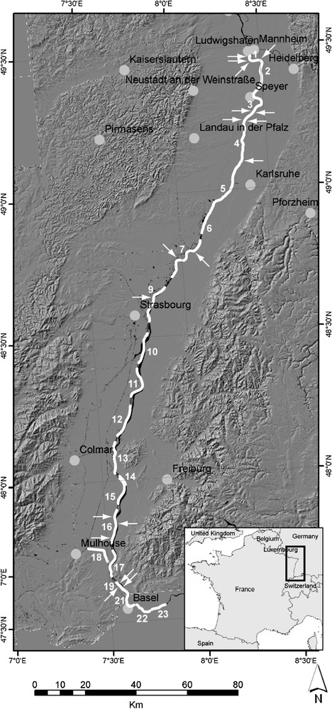
Location map of the high resolution multi-channel seismic reflection lines completed in July 2002 along the River Rhine for the MONIT Interreg III Project. Thick white lines and numbers are seismic profiles and profile numbers; white arrows show locations of faults observed on the profiles that offset Quaternary horizons.
Carte de localisation des profils de sismique réflexion haute résolution multitrace, acquise en juillet 2002 dans le cadre du projet Interreg III MONIT. Les lignes et nombres gras en blanc sont les lignes sismiques et leurs numéros ; les flèches blanches indiquent la position des failles observées sur les profils qui décalent des horizons quaternaires.
The seismic source was a 30-ci Sodera MiniGI high-pressure air gun (2000 PSI) towed at 1 m depth. Signals were received by two 24-channels hydrophone streamers also towed at 1 m depth. Distance between shot points was 3.125 m (6.25 m when ground speed was over 1.6 m/s), measured by DGPS (Trimble ProXRS with Omnistar real-time differential correction). Recorded data were stacked, time migrated and time-depth converted. Depth sections (SEG-Y 2 byte integer format) were interpreted using the Geographix SeisVision software.
3 Identification of Quaternary faulting
From well documented logs of boreholes located along the River Rhine, sedimentary horizons were identified on the seismic profiles, amongst which several are of Quaternary age. Several faults were identified, amongst which 19 clearly offset the base of the Quaternary and younger horizons (Fig. 2). Twelve out of these 19 faults were observed on the northern profiles and the remaining 7 on the southern ones. Because of their poor quality, it has not been possible to clearly identify tectonic structures on central profiles, although this does not exclude possible Quaternary faulting in this area.
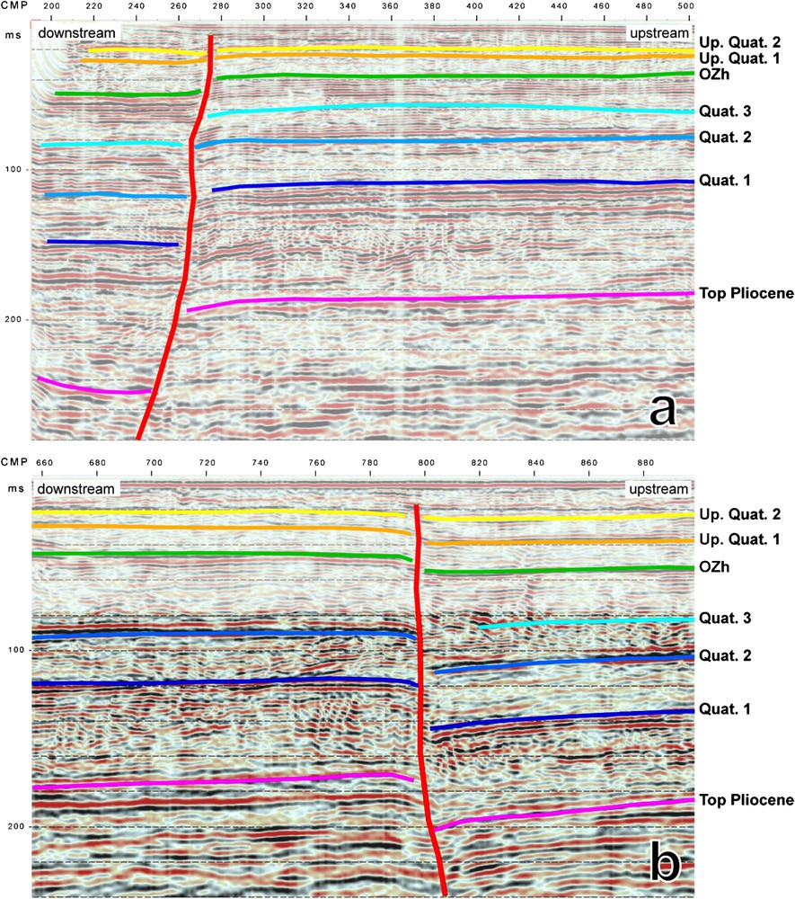
Examples of reflection seismic sections showing faults offsetting reflectors of Quaternary ages; a, line 1, CMP 270; b, line 2, CMP 800.
Exemples de profils de réflexion sismique montrant des failles décalant des réflecteurs d'âge Quaternaire ; a, ligne 1, CMP 270 ; b, ligne 2, CMP 800.
The high resolution reflection seismic profiles that were completed along the River Rhine form a linear pattern that does not allow the measurement of the strike of identified fault planes. We then tried to correlate the structures on the seismic lines with previously described faults. Industrial data in our possession did not extend close enough to the river, so we used the fault pattern from the 1979 Geothermal Synthesis [4]. Using a GIS, map locations of faults identified on seismic lines and the fault pattern of the 1979 Geothermal Synthesis were georeferenced. It was then possible to propose a strike for 15 out of the 19 faults that offset Quaternary horizons on the seismic lines. Most of these faults, i.e. 10 out of 15, strike approximately parallel to the graben (Fig. 3). The remaining five are oblique to the trend of the graben.
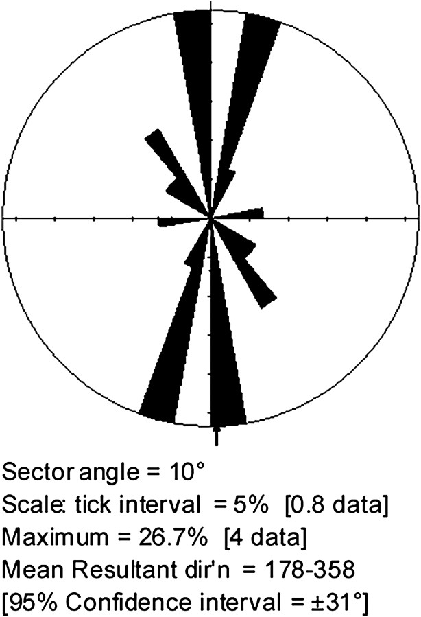
Rose diagram of proposed strikes of faults identified on the river seismic sections and offsetting Quaternary horizons, deduced from a comparison with the 1979 Geothermal Synthesis fault pattern.
Diagramme circulaire des directions des failles identifiées sur les profils de sismique fluviale et décalant des horizons quaternaires, déduites de la comparaison avec le réseau de failles de la synthèse géothermique de 1979.
However, one should keep in mind that, although the seismic line positioning using DGPS is very accurate, the georeferencing of the Geothermal Synthesis fault pattern combines several sources of uncertainties. These are: (i) uncertainty on the real location of faults in the original maps (drawn at 1/250 000 scale, and some faults were ‘deduced’ rather than ‘observed’); (ii) uncertainty resulting from scanning the original paper documents and manually digitizing the fault traces; (iii) uncertainty resulting from georeferencing the document (manual rectification). As a consequence, the strikes we propose for the Quaternary active faults observed on the seismic lines, deduced from their geographic correlation with the Geothermal Synthesis fault pattern, have to be considered very cautiously.
4 Quaternary offsets and slip rates
Nineteen faults were observed, on river seismic sections, that offset the base of the Quaternary (top of Pliocene) and, for most of them, younger horizons. Cumulated offset of the base Quaternary horizon by these faults ranges from 7.1 to 61.7 m. Despite poor constrains on fault strikes, vertical velocities averaged over the Quaternary can confidently be deduced from these apparent vertical offsets (throw, considered here as equivalent to dip separation since fault planes are all steeply dipping). Considering an age of 1.8 Ma for the base Quaternary horizon, we propose vertical slip rates ranging from 0.0039 to 0.0343 mm/yr. All are in the order of a few thousandths to a few hundredths of mm/yr (Fig. 4). These velocities are slow, even in the intraplate slow deformation tectonic context of the URG. Moreover, we considered a relatively young age for the base Quaternary horizon (1.8 Ma); an older age would have yielded even slower velocities.

Apparent vertical slip rates versus latitude (Gauss Kruger DHDN 3 metric system) diagram for 19 individual faults that affect Quaternary horizons on river seismic sections. Positive slope of the linear regression (dashed line) suggests a possible northward increasing gradient of tectonic activity.
Vitesses verticales apparentes de glissement en fonction de la latitude (système Gauss Kruger DHDN 3 métrique) sur 19 failles affectant des horizons quaternaires sur les profils de sismique fluviale. La pente positive de la droite de régression (ligne pointillée) suggère une tendance à l'accroissement de l'activité tectonique vers le nord.
One should keep in mind here that only vertical velocities are considered. The reasons are that: (i) large uncertainties are attached to the determination of fault strikes and (ii) it is not possible from our data set to quantify horizontal displacements (strike separations). However, a Quaternary strike-slip component along some faults observed on river seismic lines could not be excluded as some sections show clear ‘flower structures’ typical of such horizontal displacements.
Linear regression on the velocity versus latitude diagram (Fig. 4) has a positive slope that shows a tendency for velocities to increase northward. This might indicate a northward increase of Quaternary tectonic activity. This would be in good agreement with the distribution of Quaternary deposits within the URG, i.e. thicker to the North and thinner to the South. This observation, however, remains to be confirmed as our data are too scarce to be statistically significant.
5 Evolution of tectonic activity during Quaternary
One of the Quaternary horizons identified on the river reflection seismic profiles is the ‘Oberer Zwischenhorizont’ (OZh). Out of the 19 faults offsetting Quaternary horizons on the seismic lines, eight cut through or are sealed by the OZh horizon. These eight faults were identified on seismic lines 1 to 3 (northernmost), near Mannheim, Ludwigshafen and Speyer (Fig. 1). The OZh horizon was either absent or not identified in the vicinity of the other 11 identified faults with Quaternary activity. Based on palynology data, the OZh horizon is considered, in this area, to be of Cromerian age [3]. If we consider offsets (or absence of offset) of the two horizons of known age (base Quaternary and OZh), it is possible to deduce pre- and post-Cromerian vertical velocities (Lower Pleistocene and Middle Pleistocene to Present-day, respectively; Table 1). We have considered here a standard age of 0.7 Ma for the OZh horizon. Vertical slip rates are presented on Fig. 5. For all 8 faults, pre-Cromerian (i.e. Lower Pleistocene) velocities are faster than post-Cromerian (i.e. Middle Pleistocene to Present-day). Five faults show a clear decrease of vertical slip rates since the Middle Pleistocene relative to the Lower Pleistocene, while the remaining three ones even become inactive. These results suggest, since Cromerian time, either: (i) a decrease of tectonic activity in the URG, or (ii) a migration of tectonic activity from the Mannheim area to other (northern?) parts of the graben.
Offsets and vertical slip rates on 8 individual faults from the three northernmost river seismic profiles for the Lower Pleistocene (pre-OZh) and the Middle Pleistocene to Present (post-OZh) periods. OZh is considered to be of Cromerian age (700 kyr) in this area. See text for discussion
Décalages et vitesses verticales apparentes sur huit failles des trois profils les plus septentrionaux de sismique fluviale pour les périodes Pléistocène inférieur (pré-OZh) et Pléistocène moyen à Actuel (post-OZh). L'horizon OZh est considéré comme étant d'âge Cromérien (700 ka) dans cette partie du Fossé rhénan. Voir discussion dans le texte
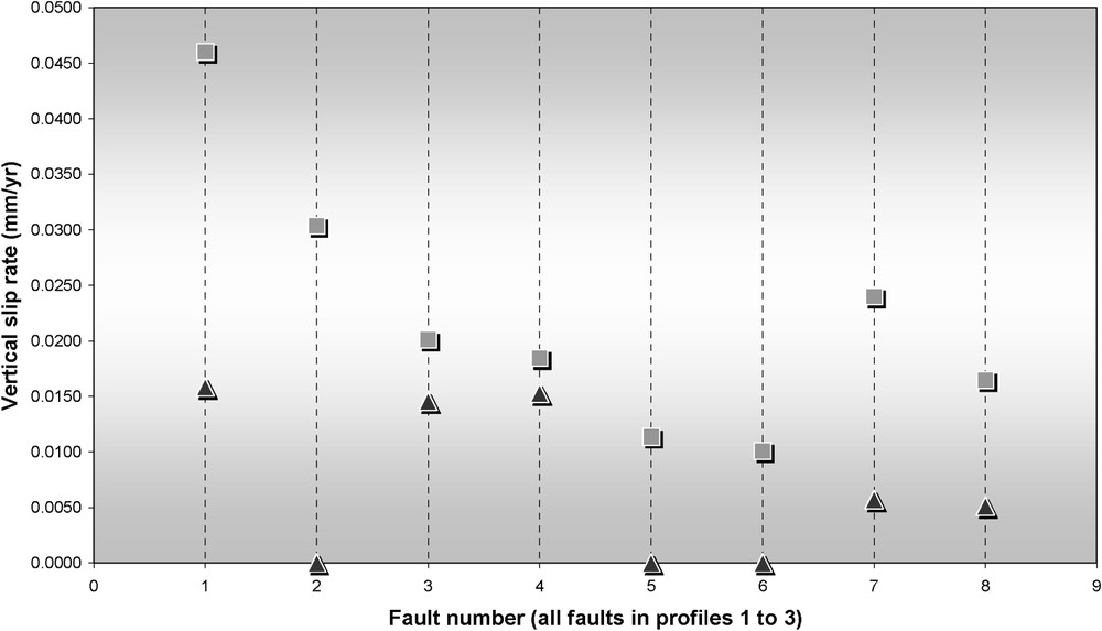
Apparent vertical slip rates during the Lower Pleistocene (grey squares) and the Middle Pleistocene to Present (black triangles) on eight individual faults from the three northernmost river seismic profiles where the OZh (‘Oberer Zwischenhorizont’) was identified. OZh is considered to be of Cromerian age (700 kyr) in this area. See text for discussion.
Vitesses verticales apparentes au Pléistocène inférieur (carrés gris) et du Pléistocène moyen à l'Actuel (triangles noirs) sur huit failles des trois profils les plus septentrionaux de sismique fluviale où l'horizon OZh (Oberer Zwischenhorizont) a été identifié. L'horizon OZh est considéré comme étant d'âge Cromérien (700 ka) dans cette partie du Fossé rhénan. Voir discussion dans le texte.
However, these data show that Quaternary tectonic activity within the URG was not uniform throughout time. It has decreased and/or been redistributed since the Middle Pleistocene. A thorough knowledge of ages of Quaternary horizons from the river seismic profiles would allow, for each fault, to trace the history of its Quaternary kinematics. Compilation of these data would display the evolution and distribution of tectonic activity within the URG through the Quaternary. To our knowledge, these chronological data are unfortunately not available at this time.
6 Conclusion
These preliminary results confirm that the URG suffered tectonic activity during the Quaternary. However, calculated vertical velocities are slow, of the order of a few thousandths to a few hundredths of mm/yr, even within the intraplate slow displacement tectonic context of the URG. A recent study from Nivière et al. [9], on major faults in the Freiburg area (southeastern URG) yielded similar velocities (of the order of a few hundredths of mm/yr since the Middle Pleistocene). On the other hand, Rozsa et al. [11] suggest higher velocities, in the order of a few tenths of mm/yr, on individual faults in the Freiburg area, although these values are deduced from levelling data and could include other causes than tectonics alone. We could not exclude, however, that large structures bounding the graben might accommodate higher velocities than intra-graben faults.
Anyway, such slow vertical slip rates suggest that the Quaternary sedimentary filling of the URG does not solely result from faulting. Other causes have to be considered, such as subsidence or climate, which may have played a major role on the Quaternary sedimentation in the URG and the shaping of its present day morphology.
In addition, these results suggest a possible decrease and/or migration of tectonic activity in the URG since the Middle Pleistocene. One should keep in mind however that we are missing, to this point, crucial chronological data (ages) on Quaternary horizons to confirm this conclusion. Such data would allow us to better constrain tectonic and kinematical processes involved in the Quaternary evolution of the URG.
These results however give new insights on the Quaternary evolution of the URG. They allow one to foresee promising research developments in active tectonics and seismic hazard, which are crucial topics in this densely populated and industrialized region.