

Version française abrégée
La limite Jurassique moyen–supérieur (Callovien–Oxfordien) représente une période de profonds changements dans la sédimentation, avec la disparition de la majorité des plates-formes carbonatées à fort potentiel de production. Ces changements sont à mettre en relation avec des modifications paléoclimatiques et dans le cycle global du carbone [1,3,9,20]. À l'échelle ouest-téthysienne, cet épisode se traduit par l'expansion des dépôts condensés à oolites ferrugineuses, des dépôts siliciclastiques et des séries marneuses et argileuses. Les séries condensées à oolites ferrugineuses et les séries sédimentaires marneuses sont également largement représentées dans l'Est du bassin de Paris pour la période allant de la fin du Callovien inférieur jusqu'à l'Oxfordien inférieur. Ces dernières séries ont été retenues par l'Agence nationale pour la gestion des déchets radioactifs (Andra) pour l'implantation d'un laboratoire souterrain dédié à l'étude des possibilités de stockage des déchets radioactifs à vie longue. Dès la base de l'Oxfordien moyen, à l'échelle du bassin de Paris comme ouest-téthysienne, une réinstallation des plates-formes carbonatées, notamment des plates-formes récifales, est observée en relation avec un réchauffement climatique [3].
Une trentaine de coupes situées sur la plate-forme bourguignonne s.l. ont été étudiées. Elles se distribuent le long d'une bande étroite orientée NE–SW et longue d'environ 150 km (Fig. 1). Les séries condensées (quelques mètres d'épaisseur) ont été étudiées en affleurement, à l'occasion de la construction de route ou rafraîchies à l'aide d'une pelle mécanique (par exemple, coupe de Courban) [6]. Le secteur en limite des départements de Meuse et de Haute-Marne a été étudié à partir de sondages carottés. La coupe de Saint-Blin, située géographiquement entre les séries condensées (quelques mètres d'épaisseur) de la plate-forme bourguignonne au Sud-Ouest et les séries dilatées au Nord-Ouest, constitue la seule coupe naturelle intermédiaire et continue (60 m d'épaisseur) couvrant le même intervalle stratigraphique.
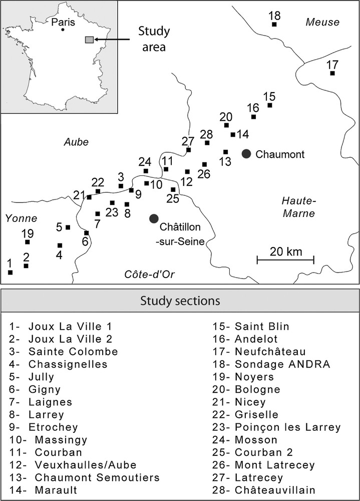
Location of the study sites in the eastern Paris Basin.
Localisation des sites étudiés dans l'Est du bassin de Paris.
Dans toutes les séries étudiées, l'abondance des ammonites permet de se caler dans un cadre biostratigraphique à haute résolution bien établi pour la période considérée [2,7,8,19,25, ce numéro]. La précision est généralement de l'ordre de la sous-zone d'ammonites, voire de l'horizon d'ammonites pour le Callovien supérieur et l'Oxfordien inférieur.
L'analyse sédimentologique des séries sédimentaires callovo-oxfordiennes de l'Est du bassin de Paris a permis de définir six faciès caractéristiques, correspondant à six environnements de dépôts, qui s'étagent depuis le domaine de transition entre le shoreface et l'offshore supérieur jusqu'à l'offshore inférieur distal [4–6]. Les faciès à oolites ferrugineuses sont répartis des milieux les plus proximaux, situés à la transition shoreface–offshore, jusqu'à l'offshore inférieur proximal. La distribution de l'abondance des oolites ferrugineuses montre un maximum dans les environnements d'offshore supérieur médian à distal (faciès 3) qui correspondent à leur milieu de formation. Elles sont aussi représentées, mais souvent sous forme de débris, dans les environnements d'offshore inférieur proximal qui correspondent aux milieux dans lesquels elles sont exportées (faciès 4). Au contraire, les oolites ferrugineuses sont rares, voire absentes à la transition shoreface–offshore supérieur proximal (faciès 1 et 2) et dans l'offshore médian (faciès 5). Les ensembles épais à dominante marneuse et sans oolites ferrugineuses, de même âge et reconnus latéralement, traduisent des environnements clairement plus profonds d'offshore inférieur distal (faciès 6).
L'étude de nombreuses coupes et la reconnaissance de différents faciès, interprétés en termes d'environnements de dépôt dans un cadre biostratigraphique très haute résolution (Fig. 2), ont permis d'établir 12 cartes paléogéographiques de l'Est du bassin de Paris, depuis le Callovien inférieur, zone à Gracilis, sous-zone à Enodatum, jusqu'à l'Oxfordien supérieur, zone à Bimammatum, sous-zone à Semimammatum (Figs. 3 et 4). La distribution des différents environnements de dépôt permet ainsi d'appréhender l'évolution paléogéographique et morphologique de la plate-forme pour la période considérée.

Sedimentary volumes conserved in each of the study sections, replaced in the high-resolution biostratigraphic framework for the period under consideration. Interpretation in terms of facies and depositional environments.
Volumes sédimentaires préservés dans chacune des coupes étudiées, replacés dans le cadre biostratigraphique haute résolution pour la période considérée. Interprétation en termes de faciès et d'environnements de dépôt.
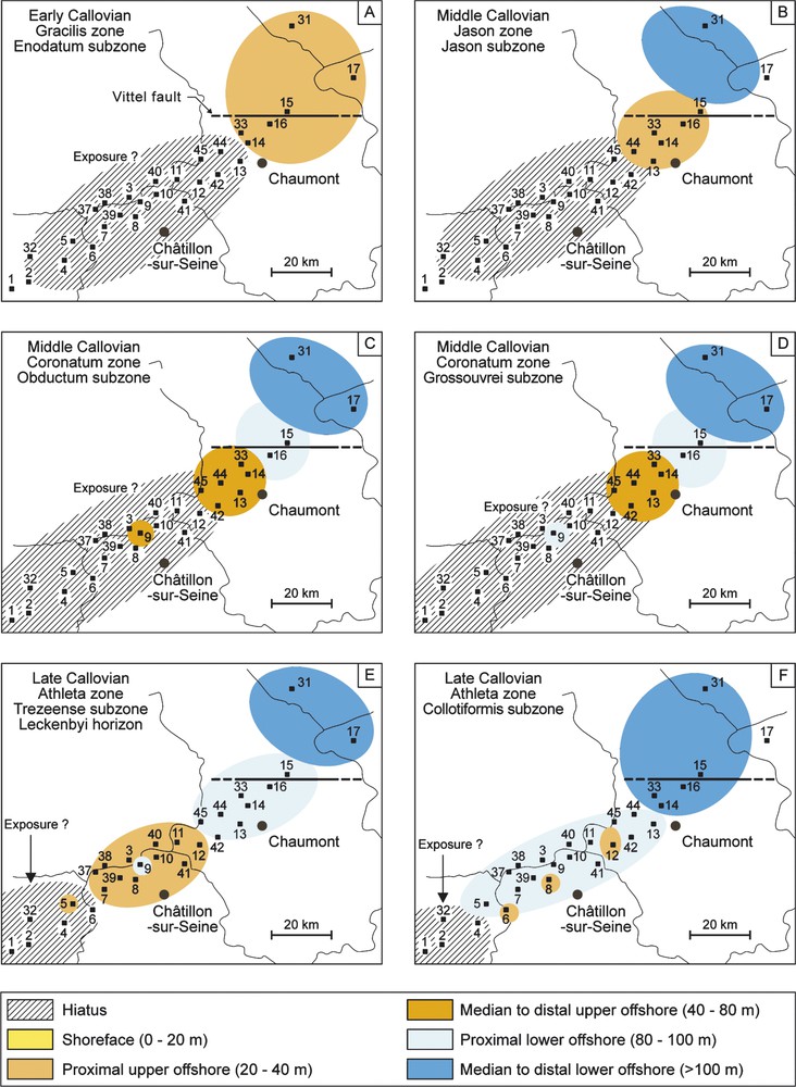
Palaeogeographical maps of the eastern Paris Basin for the Early Callovian–Late Callovian. After a break in sedimentation marked by a bored surface, with no indication of subaerial exposure, found capping the Early Callovian carbonate formations, sedimentation resumed at the end of the Late Callovian, with the deposition of new condensed iron-ooid strata (A). Progressive flooding of the shelf is observed until the end of the Late Callovian (B–F). Condensed sedimentation in the Southwest and thick marl sedimentation in the Northeast reflect two sectors with different subsidence rates. The line of transition between the two areas is the Vittel Fault.
Cartes paléogéographiques de l'Est du bassin de Paris pour la période Callovien inférieur–Callovien supérieur. À la fin du Callovien supérieur, après une arrêt de la sédimentation marqué par une surface perforée, sans indice d'émersion, repérée au toit des formations carbonatées du Callovien inférieur, la sédimentation reprend, avec le dépôt de niveaux condensés à oolites ferrugineuses (A). Un ennoiement progressif de la plate-forme est observé jusqu'à la fin du Callovien supérieur (B–F). La sédimentation condensée au Sud-Ouest et la sédimentation marneuse épaisse au Nord-Est traduisent deux secteurs avec une subsidence différentielle. La transition entre ces derniers se fait au passage de la faille de Vittel.
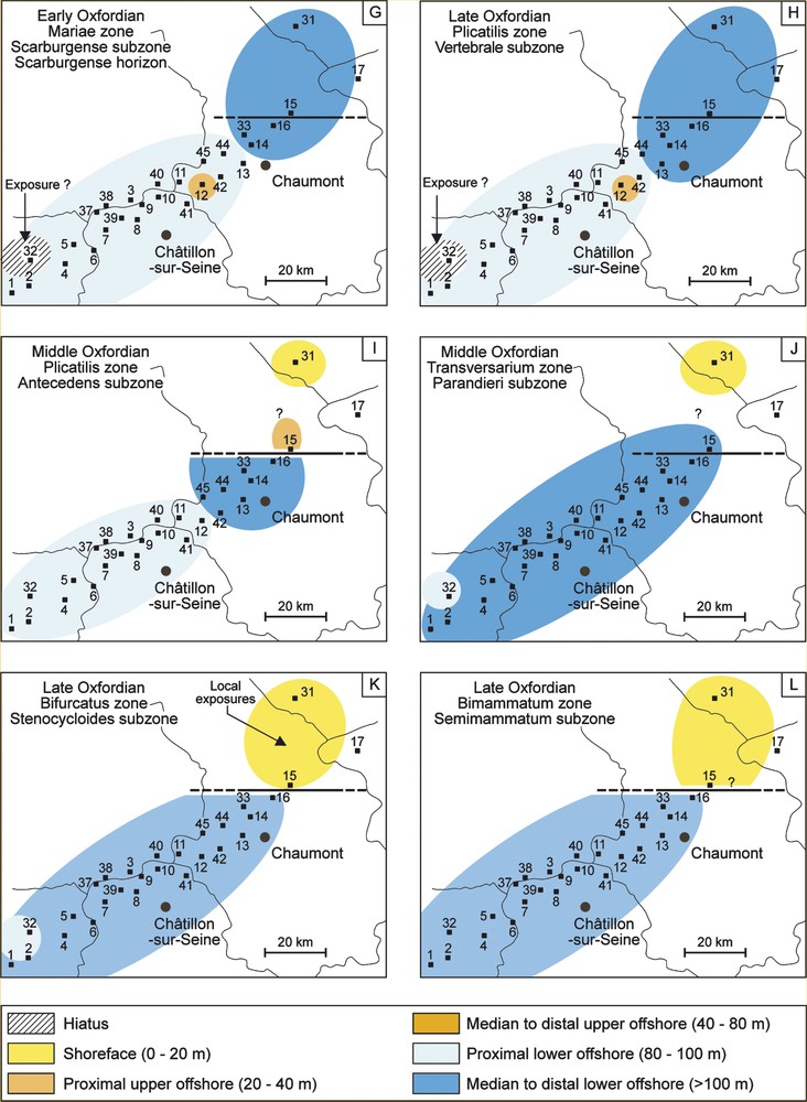
Palaeogeographical maps of the eastern Paris Basin for the Early Oxfordian–Late Oxfordian. The shelf morphology remains identical in the Early Oxfordian to that of the Upper Callovian (G, H). In the Mid-Oxfordian two palaeogeographical areas evolve differently on either side of the Vittel Fault (I, L). Drowning continues over the centre and the southeastern end of the shelf until the Late Oxfordian (K, L). A fall in the relative sea level to the northwest is evidenced by shallow-water deposits. This fall continued until the Late Oxfordian (K, L).
Cartes paléogéographiques de l'Est du bassin de Paris pour la période Oxfordien inférieur–Oxfordien supérieur. À l'Oxfordien inférieur, comme au Callovien supérieur, la morphologie de la plate-forme reste identique (G, H). À l'Oxfordien moyen, deux aires paléogéographiques à l'évolution différente apparaissent de part et d'autre de la faille de Vittel (I, L). L'ennoiement se poursuit alors sur le centre et l'extrémité sud-est de la plate-forme, jusqu'à l'Oxfordien supérieur (K, L). Au Nord-Ouest, une chute du niveau marin relatif est marquée par des dépôts moins profonds. Cette chute se poursuit jusqu'à l'Oxfordien supérieur (K, L).
Au-dessus du toit des plates-formes carbonatées du Callovien inférieur, marqué par une surface d'arrêt de sédimentation, généralement perforée, sans indice d'émersion [16], la sédimentation reprend d'abord au Nord-Est du secteur d'étude par le dépôt de niveaux condensés à oolites ferrugineuses (Fig. 3A). Ces derniers sont caractéristiques d'environnements relativement peu profonds, d'offshore supérieur proximal (fin du Callovien inférieur, zone à Gracilis, sous-zone à Enodatum). Cette reprise de sédimentation se poursuit par un ennoiement progressif de la plate-forme, marqué par la reprise de la sédimentation, de plus en plus étendue en direction du Sud-Ouest au cours du Callovien moyen–supérieur (Fig. 3B–F), de l'Oxfordien inférieur (Fig. 4G), jusqu'à la base de l'Oxfordien moyen (zone à Plicatilis, sous-zone à Vertebrale ; Fig. 4H). L'ennoiement est bien marqué dès le Callovien supérieur (zone à Athleta, sous-zone à Collotiformis ; Fig. 3F). Au cours de cette période d'ennoiement de plus forte amplitude de la plate-forme, à long terme, les environnements de dépôts d'offshore inférieur se généralisent, d'abord au Nord-Est, puis de manière de plus en plus étendue vers le Sud-Ouest. Au cours de cet ennoiement à long terme, des oscillations de plus court terme et de plus basse amplitude du niveau marin relatif ont été reconnues [6]. Par ailleurs, au cours de cette période, deux types de sédimentation s'individualisent clairement avec une sédimentation condensée à oolites ferrugineuses sur la partie sud-est et centrale de la plate-forme et une sédimentation marneuse et argileuse au Nord-Est (actuelle couche-hôte du laboratoire d'étude souterrain). Au vu des cartes établies, la subsidence différentielle semble jouer un rôle important dans la distribution de ces différents faciès. Au Nord-Est, une zone plus profonde et à plus forte subsidence est observée, permettant l'accumulation de séries marneuses épaisses (de l'ordre de la centaine de mètres, non décompactées). Au centre et au Sud-Est du secteur d'étude, la subsidence semble avoir été très faible, les séries accumulées ne faisant que quelques mètres d'épaisseur et n'ayant enregistré que des variations du niveau marin relatif de faible amplitude. La transition entre ces deux secteurs se fait au voisinage de la faille de Vittel qui a donc pu jouer un rôle dans la flexuration et l'accélération de la subsidence au Nord-Est de la plate-forme. La pérennité des aires paléogéographiques hautes et basses observées traduit une stabilité de la morphologie de la plate-forme au cours du temps.
Au cours de l'Oxfordien moyen (zone à Plicatilis, sous-zone à Antecedens), alors que l'évolution des environnements de dépôts s'était faite antérieurement de manière similaire sur l'ensemble de la région étudiée, une séparation de deux aires paléogéographiques à l'évolution distincte apparaît de part et d'autre de la faille de Vittel (Fig. 4I–L). L'ennoiement se poursuit sur la partie sud-est et centrale de la plate forme, avec généralisation, jusqu'à l'Oxfordien supérieur, sous-zone à Bimmamatum, de dépôts marneux ou à alternances marno-calcaires, tandis qu'au Nord-Ouest, à la sous-zone à Antecedens, l'apparition de niveaux plus carbonatés à polypiers lamellaires Microsolenidae marque une chute du niveau marin relatif avec le passage brutal d'environnements d'offshore inférieur à des environnements d'offshore supérieur (coupe 15) [4]. Cette chute du niveau marin relatif marquée par l'installation de récifs à polypiers ou encore par des niveaux de plate-forme carbonatée peu profonde se poursuit jusqu'à l'Oxfordien supérieur, zone à Bifurcatus [4,21]. Cette évolution résulte du jeu de la faille de Vittel dès la sous-zone à Antecedens (Oxfordien moyen) et de son influence dans l'individualisation d'un secteur peu profond au nord-est et d'un secteur profond et plus subsident au sud-ouest, au moins jusqu'au cours de l'Oxfordien supérieur, zone à Bimammatum.
En conclusion, l'étude sédimentologique et paléontologique des séries sédimentaires d'âge Callovien–Oxfordien de l'Est du bassin de Paris a donc permis de définir six faciès couvrant des environnements de dépôt situés entre la transition shoreface–offshore et l'offshore inférieur. La précision des datations biostratigraphiques a permis de définir l'âge des volumes de sédiments enregistrés dans chacun des sites étudiés, par ailleurs caractérisés en termes de faciès et d'environnement de dépôt. L'ensemble de ces données a permis d'établir des cartes paléogéographiques qui montrent un ennoiement progressif de la plate-forme du Nord-Est vers le Sud-Ouest, depuis la fin du Callovien inférieur jusqu'à la base de l'Oxfordien moyen. Cet ennoiement est marqué par le dépôt de séries condensées à oolites ferrugineuses et des séries marneuses dilatées. Au cours de l'Oxfordien moyen, au passage de la faille de Vittel, deux domaines paléogéographiques s'individualisent avec au Nord-Est, l'installation d'une plate-forme récifale et péri-récifale peu profonde, tandis qu'au sud-ouest, une sédimentation marneuse profonde persiste dans un domaine plus subsident.
1 Introduction
The Middle–Upper Jurassic boundary (Callovian–Oxfordian) corresponds to a period of extensive changes in sedimentation patterns worldwide. One significant event was the disappearance of almost all the areas with high-potential carbonate production because of global environmental changes related to climatic cooling or to disruption in the global carbon cycle [1,3,9,20]. This episode coincided with the appearance of condensed iron-ooid deposits, siliciclastic deposits and marl and clay series across the western Tethys. For the period under study, in the East of the Paris Basin, the condensed iron-ooid series and the marl series exhibit substantial differences in the sedimentation rate (a ratio of 1 : 80) between proximal platform and distal platform sectors. The ‘Agence nationale pour le traitement des déchets radioactifs’ (Andra) has selected the Callovian–Oxfordian marl series of the eastern Paris Basin as the site for an underground laboratory to study the feasibility of a repository for long-lived radioactive wastes in these ‘host beds’.
The purpose of this paper is to draw up the regional palaeogeographic and geological framework of the eastern Paris Basin in Callovian–Oxfordian times based on a sedimentological and biostratigraphic study, so as to clarify the sedimentary dynamics leading to the deposition of the current host bed, specifying its lateral equivalents and the influence of the Vittel Fault.
2 Palaeogeographical and palaeoclimatic framework
In Callovian times, the Atlantic Tethys functioned as a symmetrical ocean with a mid-ocean ridge, whereas the central Tethys was asymmetrical, with a converging northern margin and a diverging southern margin [22]. At the onset of the Callovian, varied siliciclastic shelf or shallow-basin environments, continental environments and carbonate-shelf environments were found around the margins of the Tethys Ocean [12]. The southern margin was dominated by lacustrine, fluvial and river-delta environments and shallow carbonate environments. The northern margin featured extensive siliciclastic shelf environments or basin environments. Isolated carbonate shelves were well developed (e.g., Gavrovo shelf, Russian shelf) as were shelves adjoining landmasses (e.g., Massif Central).
From the end of the Early Callovian, changes occurred in the sedimentation pattern across the entire Tethys and peri-Tethyan regions with, more specifically, the disappearance of carbonate shelves and areas of carbonate production [20]. This absence of carbonate production extended into the Early Oxfordian. This was a period of reduced sedimentation and condensed iron-ooid series were widespread, especially in the Paris Basin [5]. At the same time, thicker, predominantly clay series were deposited in Normandy [10], in the East of the Paris Basin [24] and in the French southeastern basin [15]. Elsewhere, coarse siliciclastic deposits were predominant as on the edges of the London–Brabant landmass.
From the mid-Oxfordian, condensed facies were less and less extensive and carbonate shelf facies occurred again across western Europe. These are characterised mainly by the development of coral reefs and the lateral emplacement of marl–limestone series [3,17].
These changes result in part from modifications in the global carbon cycle and palaeoclimatic variations recognised at the Middle–Upper Jurassic boundary. Palynological data [1], oxygen and carbon isotope data [9], and the palaeogeographical distribution of corals and ammonites [3] indicate a cooler, more humid period at the Callovian–Oxfordian boundary, associated with the crisis in the carbonate production. This cooling seems to have continued during the Early Oxfordian. For Mid-Oxfordian times, global disturbances are again recorded [23]. Warming of seawater and of the atmosphere, associated with increased aridity, is recognisable from fauna and flora alike [1,3]. This warming event seems to have been a preponderant factor in the resumption of shelf carbonate production [3].
3 Regional geological framework
Within this West-European Tethyan context, the intracratonic Paris Basin, whose geodynamic evolution is well known [16], recorded the same sedimentary pattern and the Callovian–Oxfordian boundary saw a drastic reduction in the carbonate production [5,9]. This is reflected, in the study sector, by the disappearance of areas of carbonate production, represented by oolitic and bioclastic carbonate deposits of shallow, wave-dominated environments (Lower Callovian; ‘Pierre de Dijon–Corton’ Formation, ‘Pierre de Ladoix’ Formation, ‘Calcaires à rhynchonelles’ Formation, ‘Dalle nacrée ferrugineuse’ Formation) [13,14]. Within a major transgressive cycle, punctuated by slight falls in the relative sea level [11], these formations were progressively superseded by condensed iron-ooid formations or by marl deposits from the end of the Early Callovian until the onset of the Mid-Oxfordian (‘Oolite ferrugineuse’ and ‘Marnes à spongiaires’ Formations) [6]. Sedimentation towards the Southeast of our study sector is represented by the ‘Argiles de la Woëvre’ Formation, the ‘Terrains à chailles’ Formation and the ‘Gaize des Ardennes’ Formation.
Thereafter, as part of a major regressive trend, carbonate sedimentation resumed and is represented by coral knolls [17] or by alternating marl–limestone series in distal environments [18].
Some 30 sections on the Burgundy Platform s.l. have been studied. They are spread along a narrow strip running NE–SW for some 150 km (Fig. 1).
The northwestern end of the sector, on the boundaries of the Meuse and Haute-Marne departments, has been studied from boreholes and cores (study site No. 18). These cover the interval from the end of the Early Callovian carbonate formations to the Mid-Oxfordian formations, which encompass the 150-m-thick clay host bed (Middle Callovian–base of the Middle Oxfordian).
The condensed series were studied from outcrops, during road-building or by using a mechanical shovel to excavate holes of 30–50 m2 and 2–4 m deep (e.g., Courban section) [6]. These series are generally less than 3 m thick and have been studied closely so as to precisely define the bed surfaces and boundaries (usually less than 10 cm), and to isolate the fauna (benthic and pelagic) and study their sedimentary structures (mechanical or biological). The Saint-Blin section, geographically between the condensed series (several metres thick) of the Burgundy Platform to the southwest and the dilated series to the northeast, is the only naturally-occurring intermediate and unbroken section (60 m thick) covering a stratigraphic interval equivalent to the other study series.
Moreover, in all our sedimentary units, the abundance of ammonites can be used to determine a well-established high-resolution biostratigraphic framework (Fig. 2) for the period under study [2,7,8,19,25, this issue]. Precision is generally of the order of the ammonite subzone and even the ammonite horizon for the Upper Callovian and Lower Oxfordian.
4 Depositional environment of the sedimentary series of the eastern Paris Basin
Sedimentological analysis of the Callovian–Oxfordian series of the eastern part of the Paris Basin distinguished six characteristic facies corresponding to six depositional environments, resumed below. These extend from the shoreface–upper offshore transition domain to the distal lower offshore (see [5] for a detailed description and interpretation).
4.1 Facies 1: Foraminifer (Spirillinid)-bearing marly limestone and marls with very rare iron ooids
The abundant bioclasts include Isognomon, bryozoans, asterids, echinoderms, crinoids, fish teeth and very rare cephalopods. Imprints of plant fronds are very frequent. 3D megaripples are sometimes observed.
Depositional environment: shoreface–upper offshore transition.
4.2 Facie 2: Fine-grained limestones with very rare iron ooids
These limestones contain a benthic fauna composed of echnoids (Collyrites), bivalves (Pholadomya, Pectinidae), gastropods (Strombaceae) and crinoids.
Ammonites are present but not abundant. Gutter casts and evidence of reworking observed on ammonite fossils are indicative of wave and current activity.
Depositional environment: proximal upper offshore.
4.3 Facies 3: Black limestone with abundant iron ooids
The macrofauna includes bryozoans, gastropods (Pseudomelania, Pleurotomaria), bivalves (Pholadomyidae, Pectinidae), regular and irregular echinoderms (Rhabdocidaris), brachiopods and sponges. Ammonites are abundant and exhibit evidence of reworking. Hummocky cross stratification is invariably observed.
Depositional environment: median–distal upper offshore.
4.4 Facies 4: Orange limestone with abundant iron ooids
The abundant benthic fauna comprises bivalves (Pectinidae including Ctenostreon, myoconchs, Pholadomyidae), echninoderms (Rhabdocidaris), gastropods (Pseudomelania, Pleurotomaria, Cerithidae, Naticidae) and scaphopods. The microfauna is composed of filaments (prodissoconches of bivalve planktonic larvae), benthic (Lenticulina) and pelagic (Protoglobigerina) foraminifera. No evidence of wave or current action is observed.
Depositional environment: proximal lower offshore.
4.5 Facies 5: Clayey limestone and marls with siliceous sponges, with or without iron ooids
The siliceous sponges are very abundant. The remainder of the benthic fauna is represented by serpulids, brachiopods (Terebratula), bivalves (Limidae, Ctenostreon), and gastropods (Pleurotomaria). Lenticulina and Protoglobigerina are found. Ammonites, mainly Perisphinctidae, are common. No sedimentary structures indicative of wave or current action are observed.
Depositional environment: median lower offshore.
4.6 Facies 6: Marls with no iron ooids and rare carbonate nodules
Bivalves (Pecten, Grammatodon, Mytilidae, Nuculidae, Oonia, Dicroloma) are the main benthic fauna with echinoderms (Disaster, Collyrites, Rhabdocidaris), gastropods (Pleurotomaria, Cerithidae) and asterids.
Depositional environment: distal lower offshore.
5 Palaeogeography and morphological evolution of the eastern Paris Basin
The study of many sections and the identification of six facies interpreted as depositional environments in a very high-resolution biostratigraphic framework (Fig. 2) have made it possible to draw up 12 palaeogeographic maps of the eastern Paris Basin from the Early Callovian (Gracilis zone, Enodatum subzone) to the Late Oxfordian (Bimammatum zone, Semimammatum subzone) (Figs. 3 and 4). The pattern of the different depositional environments provides a picture of the palaeogeographical and morphological evolution of the shelf area for the period under examination.
Above the upper strata of the Lower Callovian carbonate shelves, marked by a generally bored surface, with no indications of subaerial exposure, where sedimentation ceased [11], sedimentation resumed first to the Northeast of the study sector with the deposition of condensed iron-ooid beds (Fig. 3A), characteristic of relatively shallow proximal upper offshore environments (end of the Early Callovian, Gracilis zone, Endodatum subzone). This resumption of sedimentation was continued by progressive flooding of the shelf, marked by the return of sedimentation ever further to the southwest during the Mid–Late Callovian (Fig. 3B–F), Early Oxfordian (Fig. 4G), until the onset of the Mid-Oxfordian (Plicatilis zone, Vertebrale subzone; Fig. 4H), with pronounced flooding by the Late Callovian (Athleta zone, Collotiformis subzone; Fig. 3F). During this period of greater amplitude, long-term flooding of the shelf, the lower offshore depositional environment spread first to the northeast, and then increasingly to the southwest. During this long-term flooding, higher-frequency and lower-amplitude oscillations of the relative sea level have been identified [6]. In addition, during this period, two styles of sedimentation became clearly distinct with condensed iron-ooid sections in the southeastern and central parts of the shelf, while marls or claystones were deposited to the northeast (the current host bed of the underground laboratory). From the maps, differences in rates of subsidence seem to have played an important part in the distribution pattern of the different facies with a deeper, more subsiding zone to the northeast, where thick marl series built up (of the order of 100 m non-decompacted). In the central and southeastern sectors, subsidence seems to have been very slight, with the series built up there only a few metres thick and variations in the relative sea level recognised as being of small amplitude. The boundary between the two sectors lies along the Vittel Fault, which probably played a role in flexing and in accelerating the subsidence northeast of the platform. In addition, the persistence of the high and low palaeogeographical areas reflects the morphological stability of the platform over the course of time.
During the Mid-Oxfordian (Plicatilis zone, Antecedens subzone), whereas the depositional environments had previously evolved in similar ways across the study region, areas on either side of the Vittel Fault began to evolve in their separate styles (Fig. 4, I–L). Flooding of the southeastern and central parts of the shelf continued with the generalisation until the Late Oxfordian (Bimmamatum subzone) of marl or alternating marl–limestone deposits, whereas, to the northwest, the appearance in the Antecedens subzone of more carbonate strata with Microsolenidae corals marked a fall in the relative sea level, with a sudden shift (section 15) from lower-offshore to upper-offshore environments [4]. This fall in the relative sea level, marked by the establishment of coral reefs or by shallow carbonate-shelf beds continued until the Late Oxfordian (Bifurcatus zone) [4,21]. This evolution shows the role played by the Vittel Fault from the time of the Antecedens subzone (Mid-Oxfordian) onwards and its influence in the segregation of a shallow northeastern sector and a deep and more subsiding southwestern sector, at least until the Late Oxfordian (Bimammatum zone). On the scale of the structural framework of the Paris Basin [6], the sector to the southeast of the Vittel Fault is part of the Morvan–Vosges zone and the northeastern sector is part of the Saxony–Thuringia zone.
6 Conclusions
Sedimentological and biostratigraphical study of the Callovian–Oxfordian sedimentary series of the eastern Paris Basin has led to the identification of six facies covering environmental deposits located between the shoreface–offshore transition zone and the lower offshore. The precision of biostratigraphic datings has allowed us to identify the age of sediments at each of the study sites, which are also characterised in terms of facies and depositional environment. These data have made it possible to draw up palaeogeographical maps showing progressive flooding of the shelf from the northeast to the southwest from the end of Early Callovian times to the onset of the Mid-Oxfordian, as evidenced by the deposition of condensed iron-ooid series and dilated marl series. During the Mid-Oxfordian, two palaeogeographical domains became separated along the boundary of the Vittel Fault, with a shallow reef and peri-reef shelf to the northeast, while deeper-water marl sedimentation continued in the more subsiding area to the southwest.
Acknowledgements
The authors wish to thank J.-F. Deconinck and C. Gaillard for their reviews and J.-P. Loreau, J. Thierry, A. Bonnot and D. Marchand for their useful comments.