

1 Introduction
The New Caledonia Ridge (NCR; Fig. 1) is one of the fragments of Gondwana that drifted away from eastern Australia as a result of Late Cretaceous rifting [12]. The ridge has undergone a Paleogene orogeny, resulting in the obduction of a large ophiolite [15], which has been interpreted as the lithospheric floor of the Loyalty (oceanic) Basin flanking the ridge to the northeast [6] (Fig. 1). The main processes that have shaped the NCR during its Oligocene–Neogene post-orogenic history are:
- • extensional faulting along its margins [3,8,13,18];
- • deltaic clastic-to-carbonate sedimentation [3,7,8,18];
- • punctuated epeirogenic movements, lateritization/planation and dissection of mainland New Caledonia [5,14];
- • installation and growth of the Pleistocene barrier reef at the shelf edge [2,7].
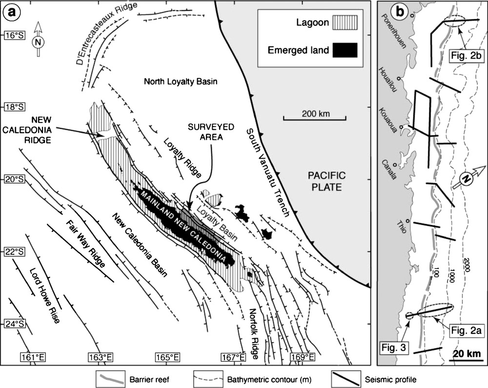
(a) Regional tectonic framework of the New Caledonia Ridge (adapted from [3]). (b) Location of the seismic profiles.
Fig. 1. (a) Cadre structural de la ride de Nouvelle-Calédonie (d’après [3]). (b) Situation des profils sismiques.
However, little is known about the space-time relationships amongst Neogene sediments, onland lateritic planation surfaces, normal faults and the barrier reef. This issue is crucial to the understanding of the morphologic, sedimentary and epeirogenic responses of passive margins to long-term sea level change and climatic variations in this complex part of the Southwest Pacific.
Here, we present the initial results of the first multichannel reflection seismic profiles acquired continuously across the outer shelf of the NCR northeastern margin and its lagoon, using the passes in the barrier reef, between 20°50′S and 22°S; these data were collected during the NEOMARGES cruise, R/V Alis/IRD, 12–21 December 2006 (Fig. 1b). Combined with observations made on samples dredged in 2005 [17], these seismic results put first-order constraints on the post-Middle Miocene morphosedimentary pattern of the NCR.
2 Main features of the upper slope of the margin
The seismic transects were precisely located on the basis of an earlier detailed multibeam bathymetric survey [16] that allowed mapping of the main morphological features of the upper slope of the margin [10]. The two profiles shown in Fig. 2 best summarize the consistent morphosedimentary characteristics of the upper margin, imaged for ∼200 km along the northeastern margin (Fig. 1b).
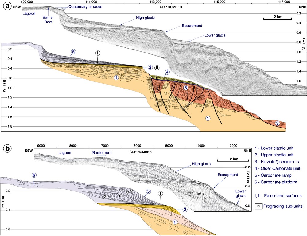
Two examples of seismic profiles across the outer shelf, northeastern margin of the New Caledonia Ridge (location in Fig. 1b). The normal faults activated before the deposition of unit 3 are shown by thicker lines.
Fig. 2. Exemples de profils sismiques de la partie sommitale de la marge nord-est de la ride de Nouvelle-Calédonie (localisés sur la Fig. 1b). Les failles normales antérieures à l’unité 3 sont figurées en traits épais.
We interpret the ‘lower glacis’ [10], identified between 300- and 900-m depths, as the abandonment surface at the top of a well-layered, reflective sedimentary sequence (unit 4), which in turn rests upon a group of low-frequency reflectors (Fig. 2a). The top of these reflectors is interpreted as an erosional lateritic land surface (II) (Fig. 2a), based on a comparison with the seismic signatures of the submerged continuation of the regional lateritic surface mapped in the southeastern part of mainland New Caledonia [1,3]. This land surface seals a 0.2-s-thick sedimentary unit (unit 3) that fills up a paleotopography carved into an older sedimentary unit (unit 1) (Fig. 2a). The wavy reflective pattern of unit 1 is interpreted as the signature of coarse, rapidly deposited (deltaic?) clastic sediments [3,18]. Dredging of the escarpment that bounds the glacis downslope suggests that unit 4 is made up of bioclastic limestones and unit 3 of conglomerates (rounded pebbles of basalt we dredged [17]).
The ‘high glacis’, identified between 80- and 450-m depths, is bounded downslope by the retreated escarpment of a master normal fault (Fig. 2). The top of the escarpment coincides with the trace of a subhorizontal lateritic surface (surface I) marking the abandonment of a layered unit (unit 2) made up of marine conglomerates (the dredged sample is made of basalt pebbles taken into a bioclastic carbonate matrix, [17]). Unit 2 is interpreted as recording a late aggradation of unit 1 (Fig. 2).
Variously inclined reflectors of unit 1 in the hanging wall of the master normal fault are suggestive of normal fault-block tilting prior to erosion and subsequent aggradation of unit 3 (Fig. 2a). A number of normal faults with small offsets affect unit 3 and are cut by paleoland surface II. These faults may reactivate earlier normal faults that had previously cut and tilted unit 1; we interpret this faulting to result from minor, possibly synsedimentary, gravity movements (Fig. 2a).
Paleoland surface I underlies a sedimentary ramp, unit 5, whose functional slope coincides with the ‘high glacis’ (Fig. 2a and b). This ramp records a transgressive and/or highstand systems tract, in which several prograding sub-units are distinguished (Fig. 2b). The uppermost slope of the ramp below the barrier shows up to five levels of terraces recording Quaternary paleosea levels (Fig. 2a; [10]). Dredging of unit 5 indicates that it is a carbonate ramp (six dredge samples provided reef limestones, grainstones and micrites, and every dredge sample provided calcareous mud and bioclastic sand [17]). The barrier reef stands at the crest of the carbonate ramp and may be correlated with the latest prograding subunit of that ramp (Fig. 2b).
3 The lagoon
The lagoon has developed on the rimmed carbonate platform lying behind the ramp (Figs. 2 and 3). Detailed marine charts indicate that the lagoon bathymetry is controlled by longitudinal (i.e., northwest-trending), flat-floored valleys (∼60-m depth) bounding elongate plateaus (∼45-m depth) and by transversal (i.e., northeast-trending) canyons that may attain 90-m depth within the passes of the barrier reef.

Part of a representative seismic profile shot within the lagoon (location in Fig. 1b).
Fig. 3. Extrait d’une ligne sismique à travers le lagon (localisé sur la Fig. 1b).
Seven seismic profiles were collected within the lagoon. The data show that the flat-floored valleys result from two episodes of river downcutting and subsequent aggradation (units 7 and 8) (Fig. 3). The second incision likely results from the entrenchment of transverse canyons and consecutive capture of the longitudinal valleys by these canyons.
4 Discussion
The present results (Fig. 2a), combined with earlier deep-penetration seismic profiles and biostratigraphy of dredged samples collected from the northeastern margin of the NCR further to the southeast [3,8], indicate that unit 3 postdates a major episode of extensional faulting and block tilting that shaped the margin no earlier than the Middle Miocene. Indeed, samples dredged from the noses of tilted blocks are coarse marine conglomerates with mid-Miocene foraminifera-bearing matrixes. (Note: one of the eleven samples had Late Miocene fauna) [3]. Unit 3 is therefore Late Miocene in age at the earliest, and probably Pliocene. Furthermore, the earlier data reinforce our interpretation of unit 1 as being the coarse clastic deltaic sequence of Early to mid-Miocene age, imaged on deep seismic profiles collected along the entire northeastern margin of the NCR [3,18] and preserved on mainland New Caledonia [3,7].
Emplacement of units 1 and 2 (Fig. 2a) was followed by the development of paleoland surface I. This surface was disrupted by Late Miocene extensional tectonics (Fig. 4).
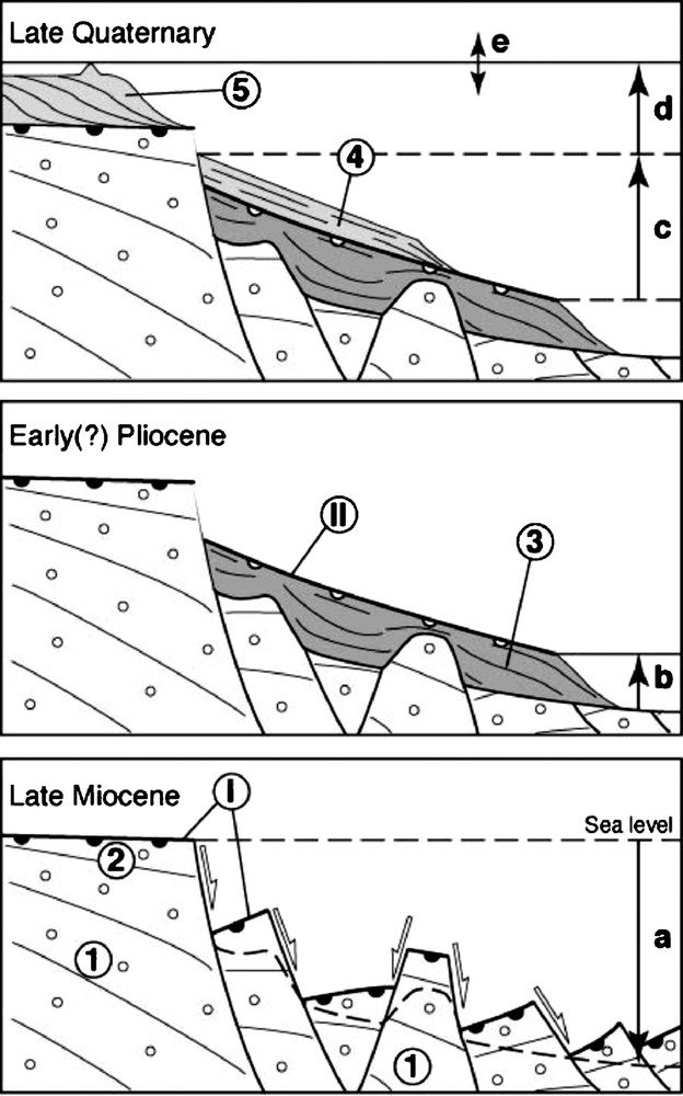
Evolutionary model for the northeastern margin of the New Caledonia ridge. Numbers refer to the morphosedimentary units shown in Fig. 2. Vertical arrows and letters refer to relative sea-level variations.
Fig. 4. Évolution de la marge nord-est de la ride de Nouvelle-Calédonie. Les chiffres décrivent les unités morphosédimentaires de la Fig. 2. Les flèches verticales et les lettres recensent les variations du niveau marin relatif.
From that time on, the undisturbed proximal continental plateau then became separated from the collapsed part of the Early to mid-Miocene clastic wedge by the escarpment created by the master normal fault (Fig. 4).
Emplacement of unit 3 results from an aggradational episode following a period of aerial dissection of the topography inherited from Late Miocene extension, in relation to a base level found today at a minimum depth of 1200 m (1.6 s, Figs. 2a and 4). After a period of relative stability allowing the emplacement of paleoland surface II, aggradation of unit 4 took place, presumably as a result of relative sea-level rise (Fig. 4).
Onland, a sequence of seven regional, lateritic erosion levels has been mapped by Chevillotte et al. [5]. Paleoland surfaces I and II (Fig. 2a) would correspond to the last two surfaces in their sequence, the preceding surface in their sequence being interpreted as the floor of unit 1 [3].
Relative sea level rise from the Late(?) Pliocene led to the abandonment of unit 4 and has provided accommodation for aggradation/progradation of the carbonate platform on paleoland surface I (Fig. 4). The depth of this paleoland surface (and therefore the thickness of the carbonate platform) continuously decreases from 450 (Fig. 2a) to 250 m (Fig. 2b) towards the northwest over the surveyed area (Fig. 1b). This regional longitudinal slope may result from warping of the margin before or during aggradation of the carbonate platform.
The two incision/aggradation cycles that have affected the floor of the lagoon are likely the result of two ice age-related sea level drops over the last two hundred thousand years (Fig. 4). This is consistent with recent work on the geology of the southwestern part of the New Caledonia lagoon [4,11] and therefore confirms the eustatic origin of these cycles.
5 Conclusion
The northeastern margin of the New Caledonia ridge has undergone overall long-term subsidence and aggradation after Late Miocene extensional tectonics. Analysis of the samples dredged from the sedimentary units imaged by the NEOMARGES seismic data will allow us to constrain the timing and mode of relative sea-level change record of the margin. Eventually, a comparison with the carbonate platform systems of Northeast Australia [9] will help us better understand the response of passive margins to Late Cenozoic climate variability in the Southwest Pacific.
Acknowledgements
Ship time was provided by the ‘Institut de recherche pour le développement’, France. The 24-channel seismic system was provided by the Institute for Geophysics, Jackson School of Geosciences, TX, USA. We thank Captain R. Proner and the crew of the Alis, as well as J.-Y. Panché and F. Gallois (IRD, Nouméa) for help and support during the NEOMARGES project. X. Le Pichon and an anonymous referee are thanked for constructive reviews. This article is UTIG Contribution No. 1933.