Plan
Comptes Rendus

Internal Geophysics (Applied Geophysics)
Integrated geophysical study of the Triassic salt bodies’ geometry and evolution in central Tunisia
[Étude géophysique intégrée de la géométrie et de l’évolution des corps salifères triasiques en Tunisie centrale]
Comptes Rendus. Géoscience, Volume 340 (2008) no. 1, pp. 10-19.

Résumés

A comprehensive study, integrating gravity, magnetic and seismic reflection data, has been used to resolve the complex Triassic salt body geometry and evolution in central Tunisia. Regional seismic lines across the study area show a detachment level in the Upper Triassic evaporites, associated with chaotic seismic facies below the Souinia, Majoura, and Mezzouna structures. The Jurassic and Lower Cretaceous seismic horizons display pinching-outs and onlapping around these structures. A stack-velocity section confirms the existence of a high-velocity body beneath the Souinia Mountain. Regional gravity and magnetic profiles in this area were elaborated from ETAP (the Tunisian Firm of Petroleum Activities) measure stations. These profiles were plotted following the same layout from the west (Souinia) to the east (Mezzouna), across the Majoura and Kharrouba mountains. They highlight associated gravity and magnetic negative anomalies. These gravity and magnetic data coupled to the reflection seismic data demonstrate that, in the Souinia, Majoura, and El Hafey zones, the Triassic salt reaches a salt pillow and a salt-dome stage, without piercing the cover. These stages are expressed by moderately low gravity anomalies. On the other hand, in the Mezzouna area (part of the North–South Axis), the Triassic salt had pierced its cover during the Upper Cretaceous and the Tertiary, reaching a more advanced stage as a salt diapir and salt wall. These stages express important low gravity and magnetic anomalies. These results confirm the model of Tanfous et al. (2005) of halokinetic movements by fault intrusions inducing, from the west to the east, structures at different stages of salt pillow, salt dome, and salt diapir.

Étude géophysique intégrée de la géométrie et de l’évolution des corps salifères triasiques en Tunisie centrale. Une étude intégrée utilisant la gravimétrie, la magnétométrie et la sismique réflexion a été menée dans le but de résoudre la complexité de la géométrie des corps salifères triasiques en Tunisie centrale. Des lignes régionales de sismique réflexion qui recoupent la région montrent des niveaux de détachement au Trias supérieur évaporitique, associés à un faciès sismique chaotique sous les structures de Souinia, Majoura et Mezzouna. Les horizons sismiques du Jurassique et du Crétacé inférieur montrent un biseautage et des onlap d’aggradation aux alentours de ces structures. Une section d’isovitesse de sommation confirme l’existence d’un corps rapide à l’aplomb de la montagne de Souinia. Deux profils intégrés, gravimétrique et magnétique, ont été élaborés à partir de stations de mesures pédestres réalisées par l’Entreprise tunisienne des activités pétrolières (ETAP). Ces profils, qui ont été dessinés suivant le même tracé, partant de l’ouest (Souinia) vers l’est (Mezzouna), traversent les structures de Majoura et de Kharrouba, et mettent en évidence des anomalies gravimétriques et magnétiques négatives associées. Ces données gravimétriques et magnétiques, couplées aux données de sismique réflexion, confirment que, dans les zones de Souinia, Majoura et El Hafey, les mouvements de sels triasiques ont atteint le stade de coussin et de dôme de sel sans percer leur couverture. Ces stades sont traduits par des anomalies gravimétriques et magnétiques modérément faibles. Cependant dans la région de Mezzouna, qui fait partie de l’Axe nord–sud, les évaporites triasiques ont percé leur couverture au Crétacé supérieur et au Tertiaire, atteignant les stades de diapir et de mur de sel. Ce travail complète celui de Tanfous et al. (2005) pour mettre en évidence, en Tunisie centrale, des mouvements halocinétiques par intrusions le long de failles préexistantes, donnant naissance, d’ouest en est, à différentes structures de coussin, dôme et diapir de sel. Par ces résultats, les auteurs rejoignent les travaux de Boukadi et de Bédir en Tunisie centrale, de Yelles Chaouach et al. dans l’Atlas saharien, de Montenat et Guéry sur la marge portugaise et de Mascle et al. sur la marge téthysienne alpine.

Métadonnées
Reçu le :
Accepté le :
Publié le :
DOI : 10.1016/j.crte.2007.11.002
Keywords: Salt bodies, Geophysics, Geometry, Evolution, Central Tunisia
Mot clés : Corps salifères, Géophysique, Géométrie, Évolution, Tunisie centrale
Hajer Azaiez 1 ; Dorra Tanfous Amri 1, 2 ; Hakim Gabtni 1, 2 ; Mourad Bedir 1 ; Mohamed Soussi 3

1 Laboratoire de géoressources, centre de recherche et de technologies de l’eau (CERTE), Borj-Cedria Techno-Park, B.P. 273, Soliman, 8020, Tunisia<
2 Département SVT, faculté des sciences de Gafsa, université de Gafsa, campus universitaire Sidi-Ahmed-Zarrouk, Gafsa, 2112 Tunisia
3 Faculté des sciences de Tunis, campus universitaire El Manar Manar, Tunis, Tunisia
@article{CRGEOS_2008__340_1_10_0,
     author = {Hajer Azaiez and Dorra Tanfous Amri and Hakim Gabtni and Mourad Bedir and Mohamed Soussi},
     title = {Integrated geophysical study of the {Triassic} salt bodies{\textquoteright} geometry and evolution in central {Tunisia}},
     journal = {Comptes Rendus. G\'eoscience},
     pages = {10--19},
     publisher = {Elsevier},
     volume = {340},
     number = {1},
     year = {2008},
     doi = {10.1016/j.crte.2007.11.002},
     language = {en},
}
TY  - JOUR
AU  - Hajer Azaiez
AU  - Dorra Tanfous Amri
AU  - Hakim Gabtni
AU  - Mourad Bedir
AU  - Mohamed Soussi
TI  - Integrated geophysical study of the Triassic salt bodies’ geometry and evolution in central Tunisia
JO  - Comptes Rendus. Géoscience
PY  - 2008
SP  - 10
EP  - 19
VL  - 340
IS  - 1
PB  - Elsevier
DO  - 10.1016/j.crte.2007.11.002
LA  - en
ID  - CRGEOS_2008__340_1_10_0
ER  - 
%0 Journal Article
%A Hajer Azaiez
%A Dorra Tanfous Amri
%A Hakim Gabtni
%A Mourad Bedir
%A Mohamed Soussi
%T Integrated geophysical study of the Triassic salt bodies’ geometry and evolution in central Tunisia
%J Comptes Rendus. Géoscience
%D 2008
%P 10-19
%V 340
%N 1
%I Elsevier
%R 10.1016/j.crte.2007.11.002
%G en
%F CRGEOS_2008__340_1_10_0
Hajer Azaiez; Dorra Tanfous Amri; Hakim Gabtni; Mourad Bedir; Mohamed Soussi. Integrated geophysical study of the Triassic salt bodies’ geometry and evolution in central Tunisia. Comptes Rendus. Géoscience, Volume 340 (2008) no. 1, pp. 10-19. doi : 10.1016/j.crte.2007.11.002. https://comptes-rendus.academie-sciences.fr/geoscience/articles/10.1016/j.crte.2007.11.002/

Version originale du texte intégral

1 Introduction

The existence of saliferous structures as well as the timing of halokinetic movements has been the subject of numerous controversies in Tunisia. Many surface studies consider central Tunisia's mountains as anticlines and reject the existence of salt domes and diapirs in this area. Moreover, different authors have suggested several epochs (Jurassic, Aptian, and Upper Cretaceous) as the beginning of salt movements based on surface [11,15,17,23] and subsurface [4,5,12,18,30] data. The seismic expression of such complex salt structures can be difficult to interpret, with perhaps little or no signal of the salt body level. However, it is precisely in these complex geological environments that the gravity and magnetic fields can be better tested and are most meaningful. The bodies with no signal on the seismic lines can be interpreted as anticlines, overthrust strata, volcanic intrusions, faults, mud mounds… The gravity method measures density lateral changes. Similarly, the magnetic method measures lateral changes in magnetic mineral content. Bouguer and susceptibility anomalies along with the velocity analysis and the seismic interpretation allowed us to identify the nature of these structures and define their geometry.

In this study, we intend to analyze subsurface structuring and complex salt features in central Tunisia from the west (Souinia) to the east (Mezzouna) across the Majoura and Kharrouba domains by integrating potential field methods (gravity–magnetic) and seismic reflection data. We further propose to deduce the geodynamic implication during Jurassic and Lower Cretaceous extension periods.

2 Geological setting

The study area is located in the central Atlas of Tunisia (Fig. 1) and is characterized by NE–SW to east–west-trending anticlines (Fig. 1). Lower Cretaceous sediments outcrop as anticline cores of Sidi Aïch, Sidi Ali Ben Aoun, El Hafey, Majoura-Meloussi, Kebar, Boudouaou mountains, and in the North–South Axis. However, the Jurassic deposits only outcrop along the North–South Axis [1,14,24,25]. The particular NW–SE-oriented structure of the Mezzouna Mountain range shows neither Lower Cretaceous nor Jurassic deposits [9,10,19] (Fig. 1). These mountains present abnormal outcropping Triassic deposits that follow NW–SE faults [9,10]. In this structure, the Campanian–Maastrichtian Abiod Formation directly overlies the Upper Triassic salt. Indeed, unconformities and lack of some stratigraphic levels have been noticed [9,19].

Fig. 1

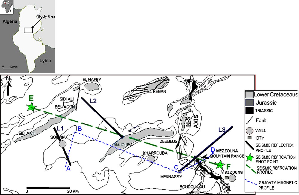
Study area location map and used seismic lines.

Fig. 1. Carte de localisation du secteur d’étude et de la maille sismique utilisée.

From the Late Triassic to the Early Aptian, the Tunisian margin seems to be characterized by submeridian and east–west extensional periods [1,5,7,8,17,28,33]. This extension reactivated reghmatic deep faults mainly oriented NE–SW, WNW–ESE and north–south [1].

Subsurface studies in this region demonstrated NE–SW, NW–SE, east–west, and north–south deep-seated flower faults, interpreted as strike-slip faults that have been reactivated since the Upper Triassic–Lower Jurassic rifting [4,18,30]. These faults bound different tectonic blocks of the region and are often associated with Triassic salt pillows and domes that are responsible for high-zone and syncline basin structuring [3–6,27,30,31].

3 Seismic analysis

The area of interest is well covered by 2D seismic lines from the Gafsa–Sidi Bouzid Permit, acquired by the AGIP (Tunisia) LTD in 1982 and 1983. However, these seismic profiles have average quality and some of them are not migrated, so care must be taken in interpreting them. Previous studies that used and analyzed these data [3–6,18,30] indicated probable salt dome existence. A recent study took interest in the geometry evolution of the salt bodies from west to east in this region.

Reflection seismic lines across the main structures of the study area have been analyzed. Seismic and sequence stratigraphic analysis, petroleum well control and surface data studies in the central Atlas of Tunisia led us to identify and to calibrate Jurassic and Lower Cretaceous horizons. We selected three migrated seismic sections crossing the main structures in this area: L1, L2, and L3.

The L1 seismic section is oriented NW–SE across the Souinia structure. It shows asymmetric anticline with large curve range affected by a flower fault system, which is associated with chaotic reflectors in the deep and apparent detachment level of the Upper Triassic (Figs. 2 and 3). The chaotic seismic facies is interpreted as Upper Triassic evaporite levels mobilized by deep faults. This movement began at least since the Lower or the Middle Jurassic [27]; it expressed itself through pinching out and onlapping into the salt pillow flank (Fig. 4). Below this structure, the correspondent iso-stacking velocity section shows a pull-up velocity anomaly that we associate with the high velocity of Triassic ascendant evaporites (Fig. 5). This configuration has been described in the Shib Mountain deep structure, situated in the southern part of this area [32].

Fig. 2

L1 seismic section showing the Souinia well above a salt pillow.

Fig. 2. Ligne sismique L1, montrant le puits de Souinia à l’aplomb d’un coussin de sel.

Fig. 3

Detailed portion of the L1 section, showing the detachment level in the Upper Triassic salt.

Fig. 3. Portion détaillée de la section sismique L1 montrant le niveau de décollement dans le salifère du Trias supérieur.

Fig. 4

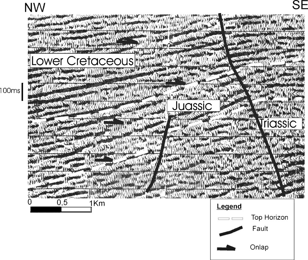
Detailed seismic section, showing pinching-out and onlapping on the dome flank.

Fig. 4. Portion détaillée d’une section sismique, montrant le biseautage et les configurations en onlap sur le flanc du dôme.

Fig. 5

L1 iso-stacking velocity section, showing a pull-up anomaly below the Souinia structure.

Fig. 5. Section d’isovitesse de sommation de la ligne sismique L1, montrant une anomalie en pull up associée à la structure de Souinia.

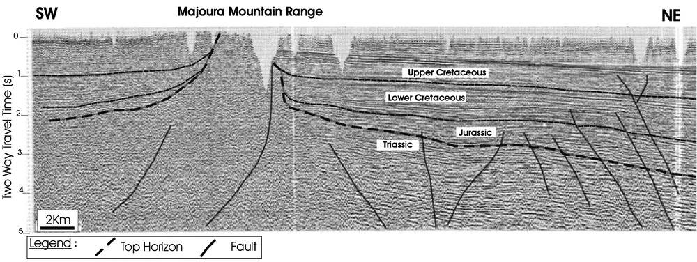
The seismic line L2, trending NW–SE, between the Majoura and El Hafey structures, (Fig. 1) shows a basin structuring as a rim-syncline depocenter to the northwest of the Majoura structure and a high platform zone extending towards the Jebel Majoura and Meloussi outcrops. The section shows chaotic seismic facies under platform highs. This facies has been interpreted as a Triassic upward-narrowing salt dome limited by major deep-seated faults (Fig. 6). These faults have a sub-vertical structure that becomes listric in the deeper horizons. The Jurassic and Lower Cretaceous seismic sequences show lateral thicknesses and seismic facies variations from the Majoura rim syncline (Fig. 6) towards the Majoura–Meloussi platform [3,27]. These sequences are bounded by eustatic and tectonic sedimentary unconformities, which are expressed by aggradational and retrogradational onlap, toplap configurations and erosional truncations [3,4,6,27,30]. Below the gutter, the Upper Triassic deposit's thickness is reduced. Thus, we can relate all this to the salt creep that was carried out towards the fault corridors since the Jurassic rifting and has continued during the Lower Cretaceous extension period.

Fig. 6

L2 seismic line, showing the Majoura Dome and the subsequent rim-syncline.

Fig. 6. Ligne sismique L2, montrant le dôme de Majoura et la gouttière synclinale associée.

The seismic line L3, oriented SW–NE across the Mezzouna area, shows a large chaotic reflector to the southwest, interpreted as ascendant evaporitic material under the Mezzouna Mountain range. Towards this structure, we noticed variations in the thickness of Jurassic and Lower Cretaceous sequences between subsiding and high blocks with aggrading and retrograding onlap and pinching-out horizons towards the high block border (Fig. 7). This has been interpreted as consequent to salt movements during these periods. The high block in Mezzouna is seen as a horst bordered by deep faults that probably facilitated salt creep and intrusion, inducing diapir formation.

Fig. 7

L3 seismic line across the Mezzouna mountain range, showing Jurassic and Lower Cretaceous thickness reduction towards the salt wall.

Fig. 7. Section sismique L3 passant par la chaîne de Mezzouna, montrant la réduction de l’épaisseur des séries du Jurassique et du Crétacé inférieur en allant vers la ride salifère.

These analyses and studies of seismic data across the whole area show differentiated structuring into highs and depocenter blocks limited by deep-seated NE–SW, north–south, east–west, and NW–SE faults interpreted as intruded by Upper Triassic salt. The early salt migration seems to have started with the platform fracturing during the Lower Liassic rifting event [27]. The salt migration is also attested to by Middle Jurassic, Upper Jurassic, and Neocomian space depocenter migrations [3,4,6,26,27,30].

4 Potential gravity and magnetic analysis

The analysis of seismic reflection profiles in central Tunisia, from the Souinia to the Majoura–El Hafey and Mezzouna zones, shows a hazy expression of complex geology. We interpret it as salt bodies, even though many geologists are still sceptical about these interpretations and about the existence of dome in this area. In such a case, the lateral changes in density (gravity method) and in magnetic mineral content (magnetic method) are of special interest, since they provide valuable information to complete and to strengthen the seismic data interpretation. Gravity and magnetic data (Fig. 9) were analyzed along an east–west profile, crossing the North–South Axis to add insights into:

  • 1) the deep structural architecture characterizing central Tunisia;
  • 2) the complex salt features.

Fig. 9

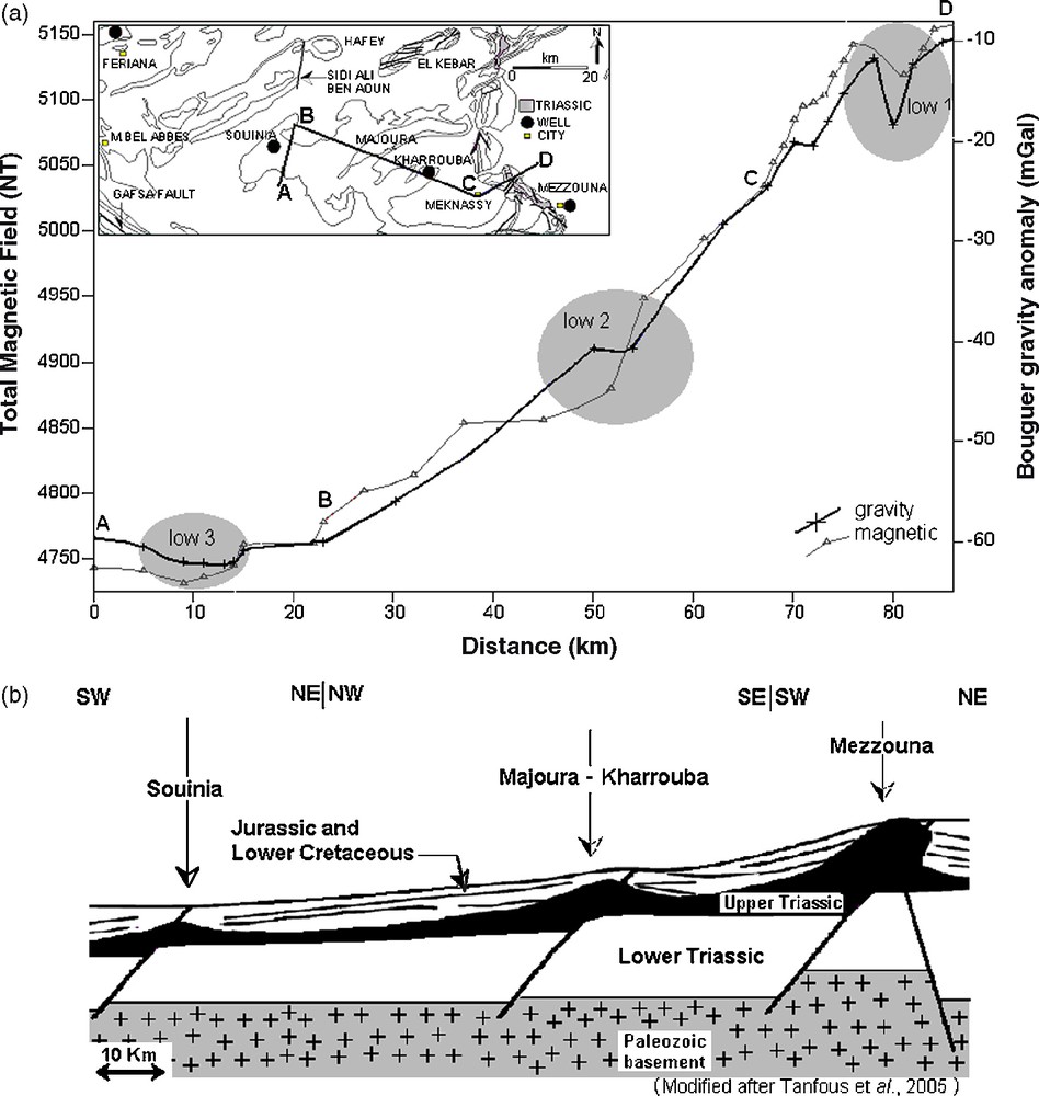
(a) Bouger gravity anomaly and total magnetic field profiles across the Souinia, Majoura–Kharrouba, and Mezzouna areas. (b) Corresponding model, showing the evolution, from the west to the east, to salt pillow, then salt dome, and salt wall.

Fig. 9. (a) Variations de l’anomalie gravimétrique de Bouguer et du champ magnétique total à travers les structures de Souinia, Majoura–Kharrouba et Mezzouna. (b) Modèle correspondant, montrant une évolution, d’ouest en est, vers des structures en coussin de sel, dôme de sel et ride salifère.

Gravity data, tied to the 1971 International Gravity Standardization Net [22], were merged and reduced using the 1967 International Gravity formula. Free-air and Bouguer gravity corrections were made using sea level as data and 2.67 g cm−3 as a reduction density. On the Bouguer gravity and magnetic profile covering central Tunisia, we can notice a regional variation from the east to the west. This variation represents the regional gravity field that is determined from crustal thickness variations [13] (Fig. 8). Fig. 8 illustrates a refraction seismic profile elaborated [16] after the seismic refraction data of Geotraverse EGT’85 [13]. This profile shows a crustal thickness reduction from the northwest to the southeast. The Moho depth in this region varies from the Atlasic basin to the Sahel domain. This explains the regional gravity anomaly and the total magnetic field variation in this direction (Fig. 9a).

Fig. 8

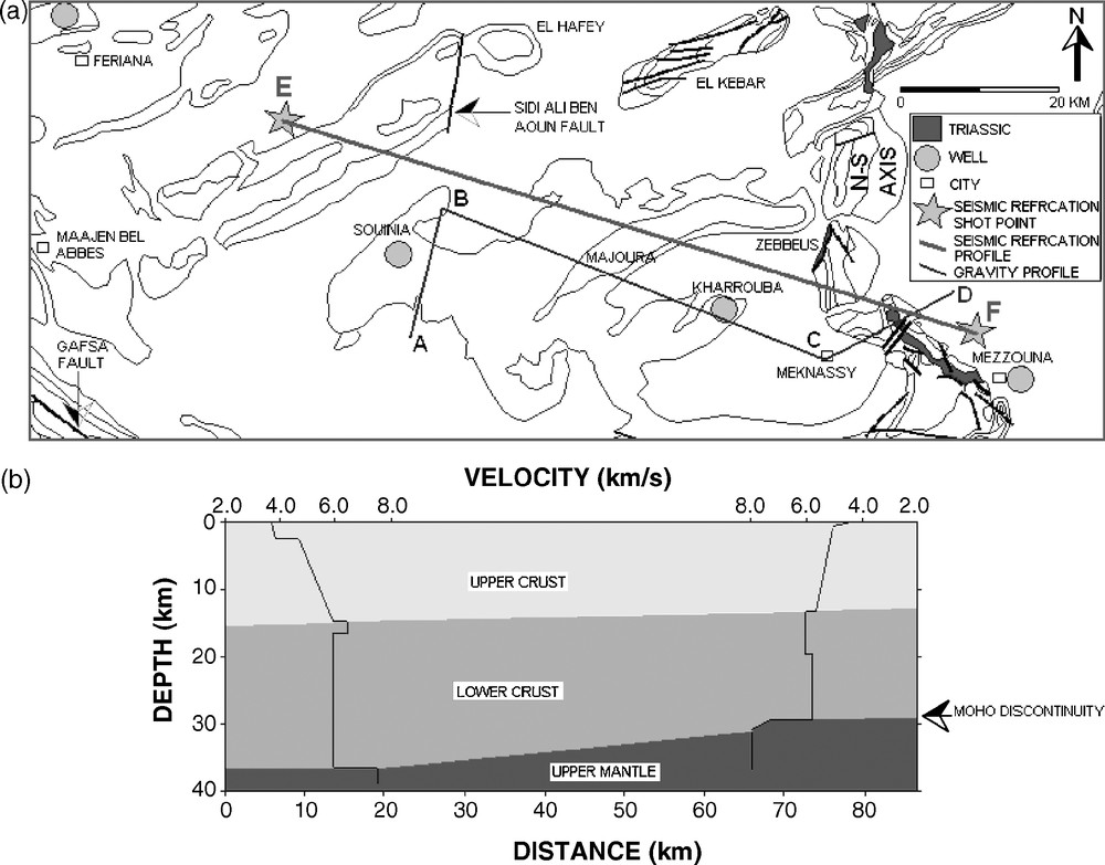
Refraction seismic profile (EF, drawn by Gabtni [16], based on Geotraverse shooting points [13]), showing a crust thickness reduction from the northwest to the southeast.

Fig. 8. Profil de sismique réfraction EF (dessiné par Gabtni, 2006 [16], en se basant sur les données des points de tir de Geotraverse [13]), montrant un amincissement crustal en allant du nord-ouest vers le sud-est.

However, other anomalies that come off the Moho effect are noticeable in Fig. 9a.

The shape and amplitude of the residual gravity and magnetic variations are represented by some anomalies resulting from basement shape and its sedimentary cover variations (Fig. 9a) [13]. Three anomalies (1, 2 and 3) have specifically been noticed. Moderately low-gravity anomalies 2 and 3 confirm that in the Souinia and Majoura-Kharrouba zones, the Triassic salt movement reaches salt pillow and salt dome stages without piercing the cover, whereas the important low-gravity and magnetic anomaly 1 in the Mezzouna area proves that the Triassic salt that outcrops in this structure is implanted as salt diapir that pierced its cover. According to the seismic analyses, this must have occurred during the Upper Cretaceous and Cenozoic compression periods.

5 Conclusion

Reflection seismic sections as well as gravity and magnetic profiles interpreted in the Souinia, Majoura–Kharrouba, and Mezzouna areas (central Tunisia) confirm the existence of buried Triassic salt bodies characterized by chaotic reflection, high-velocity propagation and negative gravity, and magnetic anomalies.

Aggrading and retrograding onlaps and pinching-out of the Jurassic and the Lower Cretaceous horizons towards these structure borders illustrate the halokinetic movements of these bodies during these periods.

The Triassic salt intrusion reached stages of salt pillow and salt dome in the Souinia and the Majoura–Kharrouba, whereas in the Mezzouna mountain range, it had pierced its cover during the Upper Cretaceous and Tertiary, reaching a more advanced stage as a salt diapir marked by important gravity and magnetic anomalies.

In this study area, the Liassic rift faulting has induced a tilted block structuring of the initial Jurassic platform [27]. This is associated with the posterior compression tectonic phases and the sedimentary loading that induced Triassic salt creep and halokinetic movements and moulded the geometry of the salt diapir along the normal faults. Such phenomena have been described in the Algerian Sahara Atlas [2,29] in the Portuguese margin [21], and in the Alps [20].


Bibliographie

[1] C. Abbès, Structurations et évolutions tectono-sédimentaires mésozoïques et cénozoïques associées aux accidents reghmatiques, à la jonction des marges Téthysienne et Nord-Africaine (chaîne nord–sud, Tunisie centrale), thèse d’État, Université Tunis–El-Manar, 2004.

[2] M. Aoudjehane; A. Bouzenoune; H. Rouvier; J. Thibieroz Halocinèse et dispositifs d’extrusion de Trias dans l’Atlas saharien oriental (NE algérien), Geol. Mediterr. XIX (1992) no. 4, pp. 273-287

[3] H. Azaïez; M. Bédir; D. Tanfous; M. Soussi Seismic sequence stratigraphy and platform to basin reservoir structuring of Lower Cretaceous deposits in the Sidi Aïch-Majoura region (central Tunisia), J. Afr. Earth Sci., Volume 48 (2007), pp. 1-18

[4] M. Bédir, Mécanismes géodynamiques des bassins associés aux couloirs de coulissement de la marge atlasique de la Tunisie, sismo-stratigraphie, sismo-tectonique et implications pétrolières, PhD Thesis, Université Tunis-2, 1995.

[5] M. Bédir; L. Zitouni; N. Boukadi; J. Saadi; R. Alouani; F. Bentimzal; S. Tlig; C. Bobier Rifting, halocinèse et structuration des bassins péri-téthysiens Jurassique et Crétacé inférieur de subsurface du domaine Atlasique central de la Tunisie (région de Gafsa–Sidi Ali Ben Aoun), Afr. Geosci. Rev., Volume 7 (2000) no. 3, pp. 289-306

[6] M. Bédir; N. Boukadi; S. Tlig; F. Ben Timzal; L. Zitouni; R. Alouani; F. Slimane; C. Bobier; F. Zargouni Subsurface Mesozoic basins in the central Atlas of Tunisia: Tectonics, sequence deposit distribution and hydrocarbon potential, AAPG Bull., Volume 85 (2001) no. 5, pp. 885-907

[7] N. Ben Ayed, Évolution tectonique de l’avant-pays de la chaîne alpine de Tunisie du début du Mésozoique à l’Actuel, thèse d’État, Université Paris-Sud, Orsay, France, 1986.

[8] S. Bouaziz, Étude de la tectonique cassante dans la plate-forme et l’Atlas sahariens (Tunisie méridionale) : évolution des paléochamps de contraintes et implications géodynamiques, thèse d’État, Université Tunis-2, Tunisia, 1995.

[9] N. Boukadi, Évolution géometrique et cinématique de la zone d’interférence de l’Axe nord–sud et de la chaîne de Gafsa (Maknassy–Mezzouna et Jebel Bouhedma) Tunisie, thèse de 3e cycle, Université Louis-Pasteur, Strasbourg, France, 1985.

[10] N. Boukadi, Structuration de l’Atlas de Tunisie : Signification des nœuds et des zones d’interférences structurales au contact des grands couloirs tectoniques, PhD thesis, Université Tunis-2, 1994.

[11] N. Boukadi; M. Bédir L’halocinèse en Tunisie: contexte tectonique et chronologie des événements, C. R. Acad. Sci. Paris, Ser. IIa, Volume 322 (1996) no. 7, pp. 587-594

[12] N. Brahim, M. Gharbi, Halocinèse et réservoirs carbonatés du Crétacé en Tunisie centrale, Actes des Premières Journées de géologie appliquée, Sfax, Tunisia, May–June 1988, pp. 110–119.

[13] H. Buness, and 17 others, The EGT’85 seismic experiment in Tunisia: A reconnaissance of the deep structures, in: R. Freeman, S. Muller (Eds.), Sixth Workshop on the European Geotraverse project, data compilations and synoptic interpretation, European Science Foundation, Strasbourg, 1989, pp. 197–210.

[14] P.-F. Burollet Contribution à l’étude stratigraphique de la Tunisie centrale, Ann. Mines Geol., Volume 18 (1956), pp. 1-352

[15] G. Creuzot; J. Ouali Extension, diapirisme et compression en Tunisie centrale : le Jebel Es Souda, Rev. Geodyn., Volume 4 (1989) no. 1, pp. 39-48

[16] H. Gabtni, Caractérisation profonde et modélisation géophysique des zones de transition entre les différents blocs structuraux de la Tunisie centro-meridionale, ‘nouvelle thèse’, Université Tunis–El-Manar.

[17] C. Gourmelin, Serrage polyphasé de paléostructures distensives dans l’Axe nord–sud tunisien : le segment Bouzer–Rheouis, thèse de 3e cycle, Université des sciences médicales de Grenoble, France, 1984.

[18] A. Hlaiem Halokinesis and structural evolution of the major features in eastern and southern Tunisian Atlas, Tectonophysics, Volume 306 (1999), pp. 79-95

[19] M. Khessibi, Études géologiques du secteur de Maknassy–Mezzouna et du djebel Kbar (Tunisie centrale), PhD thesis, Université Claude-Bernard, Lyon, France, 1978.

[20] G. Mascle; H. Arnaud; G. Dardeau; J. Deblmas; P. Dubois; M. Gidon; P.-C. de Graciansky; C. Kerckhove; M. Lemoine Halocinèse précoce sur la marge téthysienne alpine : vers une réinterprétation des zones de gypses des Alpes, C. R. Acad. Sci. Paris, Ser. II, Volume 302 (1986) no. 15, pp. 963-968

[21] C. Montenat; F. Guéry L’intrusion diapirique de Caldas da Rainha et l’halocinèse jurassique sur la marge portugaise, C. R. Acad. Sci. Paris, Ser. II, Volume 298 (1986) no. 20, pp. 901-906

[22] C. Morelli Modern Standards for Gravity Surveys, Geophysics, Volume 41 (1976), p. 1051

[23] V. Perthuisot; H. Rouvier; A. Smati Déformations antévraconiennes dans le Maghreb (Tunisie), Bull. Soc. geol. France (1988) no. 3, pp. 391-398

[24] M. Soussi, R. Enay, C. Mangold, M.M. Turki, The Jurassic events and their sedimentary and stratigraphic records on the southern Tethyan margin in Central Tunisia, in: S. Crasquin-Soleau, E. Barrier (Eds.), Peri-Tethys Memoir 5: new data on Peri-Tethyan sedimentary basins, Mém. Mus. natl Hist. nat. 182 (2000) 57–92.

[25] M. Soussi Nouvelle nomenclature lithostratigraphique « événementielle » pour le Jurassique de la Tunisie atlasique, Geobios, Volume 36 (2003), pp. 761-773

[26] D. Tanfous Amri, M. Bédir, M. Soussi, M.H. Inoubli, K. Ben Boubaker, Jurassic seismic sequence stratigraphic and structuring in the Central Atlas of Tunisia, First North African petroleum & geosciences conference and exhibition proceeding EAGE, Tunis, 6–9 October 2003.

[27] D. Tanfous-Amri; M. Bédir; M. Soussi; H. Azaïez; L. Zitouni; M.H. Inoubli; K. Ben Boubaker Halocinèse précoce associée au rifting jurassique dans l’Atlas central de Tunisie (région de Majoura-El Hfay), C. R. Geoscience, Volume 337 (2005) no. 7, pp. 703-711

[28] M.M. Turki, Polycinematique et contrôle sédimentaire associés sur la cicatrice Zaghouan–Nebhana, thèse d’État, Université de Tunis, 1985.

[29] A.K. Yelles-Chaouche; R. Ait-Ouali; R. Bracene; M.E.M. Derder; H. Djellit Chronologie de l’ouverture du bassin des Ksour (Atlas saharien, Algérie) au début du Mésozoïque, Bull. Soc. geol. France, Volume 172 (2001) no. 3, pp. 285-293

[30] L. Zitouni, Évolution géodynamique des bassins mésozoïques de subsurface des régions de Sidi Aïch-Majoura (Tunisie centrale): Sismostratigraphie, sismo-tectonique et implications pétrolières, PhD thesis, Université Tunis-2, 1997.

[31] L. Zitouni; M. Bédir; N. Boukadi; H. Ibouh; S. Tlig; C. Bobier Géométrie, chronologie et cinématique des accidents N 120-140. Exemple: accident de Majoura-Mech (données de surface et de subsurface), Afr. Geosci. Rev., Volume 4 (1997) no. 3, pp. 373-380

[32] T. Zouaghi; M.H. Inoubli; M. Bédir Contribution of seismic velocity studies to structural and lithostratigraphic reconstructions: Salt-intruded corridor ceiling and Lower Turonian Beida anhydrite deposits’ outline in the central–southern Atlas of Tunisia, C. R. Geoscience, Volume 339 (2007) no. 1, pp. 13-23

[33] H. Zouari, Évolution géodynamique de l’Atlas centro-méridional de la Tunisie : stratigraphie, analyse géodynamique, cinématique et tectonosédimantaire, PhD Thesis, Université Tunis-2, 1995.


Commentaires - Politique


Ces articles pourraient vous intéresser

Halocinèse précoce associée au rifting jurassique dans l'Atlas central de Tunisie (région de Majoura–El Hfay)

Dorra Tanfous Amri; Mourad Bédir; Mohamed Soussi; ...

C. R. Géos (2005)


Structuration profonde des dépôts de l'Albien–Maastrichtien en Tunisie centrale : nouvelle limite de l'archipel de Kasserine et implications géodynamiques

Taher Zouaghi; Mourad Bédir; Mohamed Hédi Inoubli

C. R. Géos (2005)


Contribution of seismic velocity studies to structural and lithostratigraphic reconstructions: Salt-intruded corridor ceiling and Lower Turonian Beida anhydrite deposits’ outline in the central–southern Atlas of Tunisia

Taher Zouaghi; Mohamed Hédi Inoubli; Mourad Bédir

C. R. Géos (2007)