

1 Introduction
The Bazina–Sidi Bou Krime and Jalta Triassic outcrops geographically belong to the northern Tunisian Atlas which represents the northeastern extremity of the Maghreb saliferous province (Fig. 1). These outcrops are located in the southern front of the Kroumirie-Mogod Numidian zone. The different possible mechanisms of Triassic mass outcropping have been the object of long controversies:
- • autochthonous evaporitic mass corresponding to a diapir upturning Cretaceous series in direct contact with them [14], generated by an east–west ancient fracture [1], with sometimes a submarine extrusion of saliferous mud flow [9];
- • allochthonous deposits (sole) corresponding either to a thrust sheet composed of three units, Senonian to Miocene in age [8], or to an allochthonous unit (Kasseb Paleocene to Eocene unit) overlying the autochthonous Upper Cretaceous series affected by east–west and NE–SW faults [5,6,20].
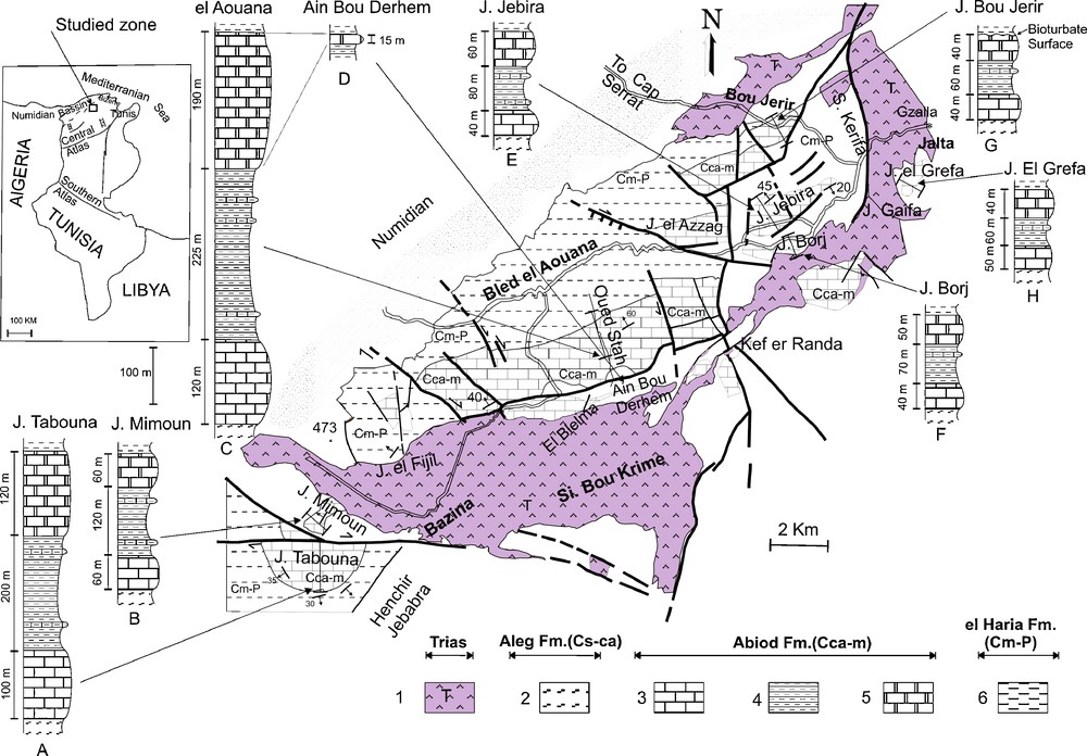
Synthetic geologic map of the Hedil country, location and synthetic lithostratigraphic sections of Campanian–Maastrichtian series. 1: Triassic; 2: Aleg Fm. Santonian–Lower Campanian; 3: Abiod Fm., lower member (Middle Campanian); 4: Abiod Fm., middle member (Campanian–Maastrichtian); 5: Abiod Fm., upper member (Lower Maastrichtian); 6: El Haria Fm. (Maastrichtian–Paleocene).
Fig. 1. Carte géologique synthétique de la région de Hédil, localisation et coupes lithostratigraphiques synthétiques des séries d’âge Campanien–Maastrichtien étudiées. 1 : Trias ; 2 : Fm. Aleg (Santonien–Campanien inférieur) ; 3 : Fm. Abiod, membre inférieur (Campanien moyen) ; 4 : Fm. Abiod, membre moyen (Campanien–Maastrichtien) ; 5 : Fm. Abiod, membre supérieur (Maastrichtien inférieur) ; 6 : Fm. El Haria (Maastrichtien–Paléocène).
In this study, new field data added to systematic surveying of the contacts, between the Bazina Triassic deposits with the neighbouring Cretaceous and Eocene sedimentary series, suggest that the present structures are the result of interferences between Triassic halokinetic movements and a synsedimentary extensive tectonics of Campanian–Maastrichtian times. This new interpretation questions the hypothesis of allochthonous evaporitic Triassic in the Hedil region [5,6,8,20].
2 Lithostratigraphical and sedimentological data
The Bazina–Sidi Bou Krime Triassic evaporitic mass is located between Aouana chain to the north and Jebel Tabouna and Jebabra shelf to the south (Fig. 1).The Triassic outcrops of Jalta and Bou Jerir constitute the oriental extension of the Triassic evaporitic mass.
In this area, the Upper Cretaceous and Palaeocene sedimentary series are subject to important thickness variations, especially at the proximity of the main saliferous body.
Three lithostratigraphic formations are present. They are from bottom to top:
- • the Aleg Formation (Fm.) (Santonian to Lower Campanian) composed by thick series of marls;
- • the Abiod Fm. (Middle Campanian to Lower Maastrichtian), mainly made up of chalky limestone. It is composed of two carbonate members (lower and upper members) separated by a marly and clayey middle member [7]. This formation was subject to detailed stratigraphic analysis based on microfaunas [1,9,14,19,21,22];
- • the El Haria Fm. (Upper Maastrichtian to Palaeocene), mainly constituted of marls.
2.1 Jebel Tabouna and Jebel Mimoun
These outcrops are located in the southwestern extremity of the Bazina–Sidi Bou Krime Triassic outcrops (Fig. 1).
The Jebel Tabouna mass is an anticline of submeridian orientation, showing a periclinal termination to the north, interpreted as half dome or as part of the Hedil thrust [8]. The three above described formations are present (Fig. 1, section A). The Abiod Fm. is particularly thick (420 m).
The Jebel Mimoun represents the northern extremity of this structure displaced by right-lateral east–west strike-slip network. At the contact with the Bazina Triassic, the Abiod formation, represented by its three members, undergoes a clear thickness reduction (240 m) (Fig. 1, section B).
This important thickness variation of the Abiod Fm. is thought to be induced by contemporaneous sedimentation and halokinetic movements and by synsedimentary extensive tectonics [3,4].
2.2 El Aouana chain and satellites Jebels
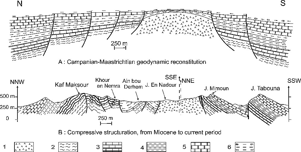
Situated in the North of the Bazina–Sidi Bou Krime saliferous mass, the Aouana massif has already been subject of numerous studies [1,8,10,13,16,21]. The Abiod Fm. is very thick (535 m) (Fig. 1, section C, cross-section of Oued Stah). The lower member begins with limestone rich in bioclasts of Inoceramus, echinoderms and shellfish [13,17,21]. These carbonates are also marked by slumps and by the presence of synsedimentary normal faults, testifying to the instability and suggesting contemporaneous tectonic activity during the sedimentation [4]. The top of Abiod Fm. is characterised by a progressive enrichment in marls composing the El Haria Fm. occupying the Bled El Aouana Plain.
Important lateral variations in thickness are evidenced in the neighbouring outcrops.
2.2.1 Ain Bou Derhem Plain (Fig. 1, section D)
In the northern border of the Bazina Triassic outcrops, one limestone bar that does not exceed 20 m of thickness, was interpreted by Kujawski [14] as a slice slightly visible. This bar is stratigraphically sandwiched between two marly levels dated by microfauna (by N. Karoui Yaakoub). The bar overlies marls with limestone intercalations dated Upper Campanian to Lower Maastrichtian (Globotruncana falsostuarti biozones) and underlies marls dated Upper Maastrichtian (Gansserina gansseri and Abathomphalus mayaroensis biozones). Hence, the limestone bar is attributed to the superior member of the Abiod Fm. entirely Lower Maastrichtian in age. It is very condensed at the immediate contact with the Triassic mass of Bazina–Sidi Bou Krime. This important thickness reduction, around the Bazina–Sidi Bou Krime Triassic mass, is attributed to the halokinetic movement during the Lower Maastrichtian.
2.2.2 Jebel Jebira (Fig. 1, section E), Jebel Borj (Fig. 1, section F) and Jebel El Grefa (Fig. 1, section H)
These massifs are located in the northeastern continuity of El Aouana chain in contact with Jalta Triassic mass. The Abiod Fm. thickness, also reduced, does not exceed 180 m of thickness in Jebel Jebira, 160 m in Jebel Borj, and 150 m in Jebel Grefa (Fig. 1).
2.2.3 Jebel Bou Jerir (Fig. 1, section G)
Between the Jalta and Bou Jerir Triassic outcrops, the Cretaceous is unconformably covered by Upper Miocene continental deposits [15]. The Abiod Fm. (140 m) displays a clear thickness reduction of its three members, especially the upper one (40 m) of which the top is marked by a bioturbated surface with reworked conglomeratic elements characterising the base of El Haria Fm. This level highlights the existence, during the Maastrichtian, of sedimentation local perturbations and of synsedimentary movements compatible with neighbouring Triassic halokinetic extrusions.
2.3 Sedimentological conclusions
The Abiod Fm. thickness which is very developed in the central part of El Aouana chain (up to 535 m), is strongly reduced close to the Triassic evaporitic outcrops: 240 m at Jebel Mimoun located at the western extremity of Bazina Triassic; 180 m at Jebel Jebira and 160 m at Jebel Borj at the eastern extremity of Bazina Triassic with a maximum condensation at Ain Bou Derhem in direct contact with the Triassic; 140 m at Jebel Bou Jerir and around 150 m at Jebel El Grefa near the Triassic masses of Bou Jerir and Jalta.
These sedimentary thickness reductions can be related to diapiric movement activity and are associated with sedimentological perturbations (slumps, synsedimentary faults) invoking the presence of extensive synsedimentary tectonics [3,4].
To the West of Jebel Mimoun, and more precisely at Kef Zaraa (Fig. 2F), Ypresian Globigerinid-rich limestones overlying the Upper Maastrichtian–Palaeocene (El Haria), undergo a progressive thickness reduction near the Triassic (Fig. 2, section F). This lateral thickness variation, already highlighted [9], can be justified by the effect of a Triassic diapiric extrusion during the Lower Eocene.
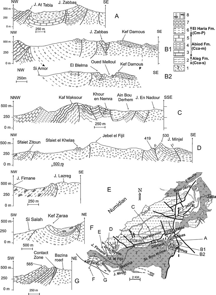
Structural sections showing the geometry of the contact between the Bazina Triassic diapir and the enclosing rock beds. 1: Triassic; 2: Aleg Fm. (Santonian–Lower Campanian); 3: Abiod Fm., lower member (Middle Campanien); 4: Abiod Fm., middle member (Campanian–Maastrichtian); 5: Abiod Fm., upper member (Lower Maastrichtian); 6: El Haria Fm. (Maastrichtian–Paleocene); 7: Ypresian (Globigerinids limestones); 8: Middle Eocene (shales).
Fig. 2. Coupes structurales sériées montrant la géométrie du contact entre le Trias diapirique de Bazina et les couches encaissantes. 1 : Trias ; 2 : Fm. Aleg (Santonien–Campanien inférieur) ; 3 : Fm. Abiod, membre inférieur (Campanien moyen) ; 4 : Fm. Abiod, membre moyen (Campanien–Maastrichtien) ; 5 : Fm. Abiod, membre supérieur (Maastrichtien inférieur) ; 6 : Fm. El Haria (Maastrichtien–Paléocène) ; 7 : Yprésien (Calcaires à Globigérines) ; 8 : Éocène moyen (argiles).
3 Tectonic data
The structural relations between the Triassic deposits and the Cretaceous and Tertiary series in contact with them are analyzed, based on serial cross-sections chosen at the border of the Bazina–Sidi Bou Krime evaporitic mass (Fig. 2, sections A, B1, B2, C, D, E, F and G). These sections allow us the following observations:
- • the Triassic deposits generally plunge under the surrounding Upper Cretaceous strata (sections A, D and G) or the Ypresian series (sections B1, B2, D, E and F). The stratigraphic succession of these series is as recent as it is far from the Triassic. To the West of the Bazina village (Fig. 2, section D), the local Triassic overlap on Santonian–Lower Campanian marls [5,6,14,20] is a limited phenomenon corresponding to an extravasion. At jebel Mimoun (Fig. 2, section G) and at Jebel Zabbes (Fig. 2, section A), the Triassic always clearly plunges below the Upper Cretaceous series;
- • at their contact with Triassic, Upper Cretaceous series are sometimes upturned or overturned (Fig. 2, sections D, E, G), and even sometimes strongly folded (Fig. 2, sections A, B1, B2, C, F);
- • at the Triassic–Cretaceous contact (Fig. 2, section G), the Abiod Fm. limestone sometimes forms 20 m thick mineralized tectonic breccias. Such breccias have been already described at diapirs borders in Tunisia [18];
- • at Kef Damous (Fig. 2, section B1), the Ypresian polypary and corals rich-sandy-limestones overlap the Triassic, directly or through a marly layer with an erosional stratigraphic contact;
- • at Oued Melloul (Fig. 2, section B2), a collapsed block of metric El Haria Fm. overlies the Triassic. Stratigraphically glauconitic levels are also observed at the top of El Haria Fm. marls at 2 km to the northeastern of this locality. This observation questions the interpretation which defines these outcrops as a tectonic window appearing under the Triassic deeply entailed by Oued Melloul [5,6,8,19].
Moreover, these observations demonstrate that the Upper Cretaceous to Palaeocene series were deposited near a well rooted and active saliferous mechanism. The unconformity of the Maastrichtian–Palaeocene marls on the Triassic deposits proves that the latter were already outcropped during the Late Cretaceous.
4 Interpretation and conclusion
Our lithostratigraphic, tectonosedimentary and structural analysis of the northeastern part of Tunisia (Hedil country) shows that the various series of the Upper Cretaceous–Palaeocene were deposited on the border of a saliferous mechanism corresponding to the present Bazina–Sidi Bou Krime, Jalta and Bou Jerir saliferous masses. The diapiric extrusions of evaporitic masses constituting these saliferous mechanisms would be responsible of the thickness variations noted in the Campanian–Maastrichtian series of the Abiod Fm. This movement seems to have been set off by synsedimentary NE–SW extensive tectonics that affected this sector (Fig. 3A and B) [4] and the rest of Tunisia during this period [2,11,12].
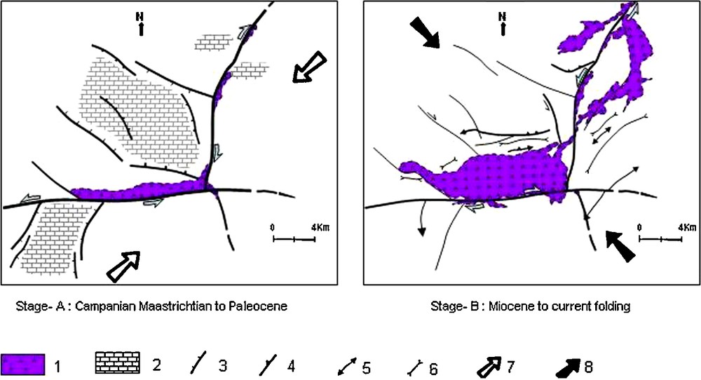
Geodynamic evolution of Hedil country from the Campanian period to actually. 1: Triassic; 2: area of important Campanian–Maastrichtian deposits; 3: normal fault; 4: reverse fault; 5: anticline; 6: syncline; 7: Africa–Eurasia rapprochement and coulissage direction; 8: shortening direction after the Africa–Eurasia collision.
Fig. 3. Évolution géodynamique de la région de Hédil, du Campanien à l’Actuel. 1 : Trias ; 2 : zone d’importantes accumulations de dépôts d’âge Campanien–Maastrichtien ; 3 : faille normale ; 4 : faille inverse ; 5 : anticlinal ; 6 : synclinal ; 7 : direction de rapprochement et de coulissage Afrique–Eurasie ; 8 : direction de raccourcissement après la collision Afrique–Eurasie.
The systematic analysis of the geometrical relations between Triassic sediments and the upturned or even overturned contacts confirms the rooting of the evaporitic sediments and their diapiric origin. This analysis allowed the rejection of all previous allochthonous hypotheses proposed [5,8,20] and presents a new interpretation that excludes the presence of “Kasseb unit” in the studied area.
The current structures are the result of interferences between diapiric movements and syn-Campanian–Maastrichtian active extensive tectonics (Figs. 3A and 4A), the folding of the group occurred during the Miocene (Figs. 3B and 4B).
Proposed model concerning the relationships between the Bazina–Sidi Bou Krime Triassic materials and the surrounding sedimentary formations, in the Campanian–Maastrichtian period and actually; 1: Triassic; 2: Aleg Fm. (Santonian–Lower Campanian); 3: Abiod Fm., lower member (Middle Campanian); 4: Abiod Fm., middle member (Campanian–Maastrichtian); 5: Abiod Fm., upper member (Lower Maastrichtian); 6: El Haria Fm. (Maastrichtian–Palaeocene).
Fig. 4. Modèle proposé pour expliquer les relations entre le Trias de Bazina–Sidi Bou Krime et les domaines sédimentaires avoisinants au cours du Campanien–Maastrichtien et actuellement. 1 : Trias ; 2 : Fm. Aleg (Santonien–Campanien inférieur) ; 3 : Fm. Abiod, membre inférieur (Campanien moyen) ; 4 : Fm. Abiod, membre moyen (Campanien–Maastrichtien) ; 5 : Fm. Abiod, membre supérieur (Maastrichtien inférieur) ; 6 : Fm. El Haria (Maastrichtien–Paléocène).
Acknowledgments
The authors are grateful to the professors P. Fauré and J. Canérot for their judicious remarks and their contribution to the improvement of this manuscript. We thank also professors M. Durand-Delga and M. Petit for there critical observations and constructive suggestions.