

1 Introduction
The Syrian rift corresponds to the northern part of the Dead Sea fault zone (DSFZ), formed during the 8–0.4 Ma (million years) time interval, in continuity with the Red Sea rift zone (24–16 Ma) [3,9,12]. Along this rift, two major phenomena occur: intraplate volcanism, from Jurassic–Cretaceous to present [23,27,28], and earthquakes, known since historic times (the oldest earthquake was recorded in 1879 BC in Anatolia [1,32]).
Seisms take place within the lithosphere, in response to active fault displacement [18,35]. Their magnitude depends on the energy liberated, which is related to the movement rate along the productive faults. However, other seisms could also originate when the crust is subducted into the mantle, or along rifts in response to an ascending hot spot (plume) [9,35]. This is precisely what may happen in Syria. The study of volcanic xenoliths has identified a hot spot under the Arabic plate [25,28,29], starting during the Cretaceous and ascending continuously until present time [6,7]. The last volcanic eruption took place in the southern part of the country, about 10,000 years ago, at the end eruptive phase which started less than 1 Ma ago [14,23].
This paper analyzes the seismicity distribution in the Syrian territory, using tectonic activity, laboratory measurements, and historic and recent earthquakes records. These data will also be compared to volcanic–petrological parameters.
2 Seismic parameters and seismicity analysis
The analysis of seism distribution in Syria is done on the basis of the following parameters: movement rate along the rift, seismic acceleration coefficient (Z), oedometric experiments in the laboratory and evaluation of the earthquake historical record.
2.1 Movement rate: active faults along the Syrian rift
Structural analysis and field observation, in addition to satellite imagery data and geomorphological analysis, attest that many faults have recently been or are still active along the Syrian rift. This is indicated by several lines of evidence, notably:
- • the local transformation of basaltic rocks into mylonites and fine-grained shear zones; carbonate basement rocks may also be deformed, being more mylonitic because more easily fragmented than basalts;
- • the occurrence of pull-apart basins filled with Quaternary sediments;
- • the deformation of small active ravines, with the formation of scarps.
The values of movement rate–displacement along a given fault could be estimated in the region of Homs, where important basaltic eruptions took place 6 Ma ago [11,26]. The overall displacement along the fault since the time of eruption, in other words, the total length of pull-apart, could be estimated from the displacement of the famous “Krak des Chevaliers”, in respect to the main Shine volcano (Fig. 1). This mode of evaluation gives 16 km, significantly less than other estimates along the same fault from other reference points, which reach about 20 km [13]. The average displacement rate would then be 2.7–3.3 mm/year, in line with estimates along the Wadi Araba fault, in the northern part of the Levant fault (4.6 ± 2 mm/year, with a decreasing value of 2.3 mm/year for the last 12 ka [19]). In Syria, this displacement rate in the region of Homs corresponds to a maximum value. It decreases significantly towards the east to reach 1–1.5 mm/year in the region of Palmyra, less than 1 mm/year in the eastern and northeastern parts of the country [4].
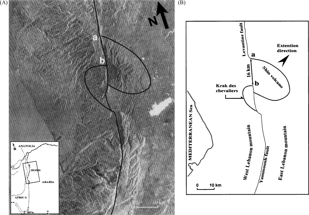
Movement rate estimates, from field observation and satellite imagery analysis (Landsat TM 1995). A. Main active fault, forming a pull-apart basin, and major structures on both sides of the Syrian fault. B. Schematic calculation of the movement caused by the faulting active movement; ab: displacement, estimated at 16 km during 6 My, the age of the Homs basalt.
Fig. 1. Valeur du mouvement, estimé d’après les observations de terrain et l’analyse de l’imagerie satellitaire, Landsat TM 1995. A. Structure de la faille active, constituant un bassin « pull-apart » et structures principales de deux côtés de la faille syrienne. B. Calcul schématique du mouvement causé par la faille. ab: déplacement estimé à 16 km pendant 6 Ma, âge du basalte de Homs.
These results are confirmed by physical effects on building structures, represented by characteristic foundation deformation, including: discontinuities, horizontal and vertical shifts of structural parts elements, divergence of wall stones and arches, tilted walls, cracks, etc., in several areas of the region: Missyaf, Qalaat Soulyman, Rissafa, etc. [8,21]. Values indicated above can be taken as an average value for the movement rate distribution in the whole Syrian territory.
2.2 Seismic acceleration coefficient (Z)
For an earthquake of a given intensity, defined by the value of its magnitude (according to the Richter scale), the action on a built structure [8], which results in the greatest number of casualties, depends from two sets of parameters: the characteristics of the structure itself and the nature of the ground on which it is built. Several equations are proposed to relate all these variables [10,22]. The Syrian code [31] used in this work is based on the following equations:
The most critical parameter is the seismic acceleration coefficient, Z. Estimated in cm/S2, it describes the reaction of an object, or structure in a limited zone, to an earthquake of a given intensity. A coefficient of 0.1 indicates that a building must be designed in such a way that it can resist during an earthquake to a force of 10% of its weight applied horizontally [10].
Depending on the different parameters, its value changes from a region to another, as well as within a single region, from 0 to a maximum of 1.5 cm/S2 [10]. For dams, it is estimated in Japan at a value of 0.1–0.12 for weak earthquake zones, 0.15 for strong ones. It is estimated between 0.05 and 0.20 in Turkey, and between 0.03 and 0.24 in India.
In Syria, Z values range between 0 and 0.25, depending on the region: 0.25 in the vicinity of Al Ghab, 0.12 in Palmyra, and 0.05–0.1 in Deir Zour, in the eastern part of the country.
2.3 Laboratory oedometric experiments
Oedometry measurements allow one to estimate time-dependent consolidation and porosity parameters of argillaceous soils under a given load [16]. In order to evaluate seismic hazards on the whole Syrian territory, as well as their effects on building structures, oedometric laboratory experiments have been done on the more representative soil types occurring in the country. Using a scale of magnitude intensity of 7, 7.5, 8, and 8.5, respectively, the elasticity modulus E (power/surface, expressed in kilonewton/m2), and the Poisson ratio (= executed displacement/original displacement = dl/l = deformation %) have been determined. These parameters characterize the soil rigidity, which influences the behavior of a building during a given seism. In other words, they define the interaction soil–seism for a given building. In total, more than 80 lithological samples have been analyzed, using the SAP Software (computer and structures Inc., USA [5]). Detailed results are available from the author upon request. On an oedometric scale covering high to low relative seism/soil effect on a building (poorly consolidated to well consolidated soils), all Syrian samples investigated remain within a moderate range. Risk is maximal along the rift (moderate), gradually decreasing towards the east, southeast and northeast (low).
2.4 Earthquake historical analysis
The last type of information that we can have on the seism risk in Syria derives from the evaluation of recorded seisms in historical times. It relies on the notion of seismic cycle, namely the repetition (frequency return period) of an earthquake in the same locality. This notion is highly controversial [17,20]. However, even if an earthquake is unique for a given locality, the time-dependent regional distribution of earthquake activity is a factor of major importance.
In consequence, we have analyzed the historical record of ancient earthquakes, using only those verified by different sources [15,21,32] (Fig. 2). Oldest recorded earthquake in Syria occurred in 749, in the Yammouneh-Ghab area, with a magnitude of 7.5–7 [21]. Since that time, more than 100 earthquakes have been recorded, whose maximum magnitude significantly decreases with time: six earthquakes with a magnitude of 7.5–6.5 in ancient times (between 749 and 1800) [21], 33 with a magnitude of 6–5 between 1800 and 1960 [2,24,30,32], 26 with a magnitude lower than 5 for the period 1960 to 2000 and finally 38 with a magnitude between 4.9–4 until present times [34]. For recent seisms, we have collected good data, issued from the analysis of physical effects on the structures and/or recorded by the station seismic network [2,33,34]. The greater number of recorded earthquakes in recent years (after 1960) is certainly due to improved surveying apparatus and observation network. The overall trend, however, seems to indicate more earthquakes of smaller intensity.
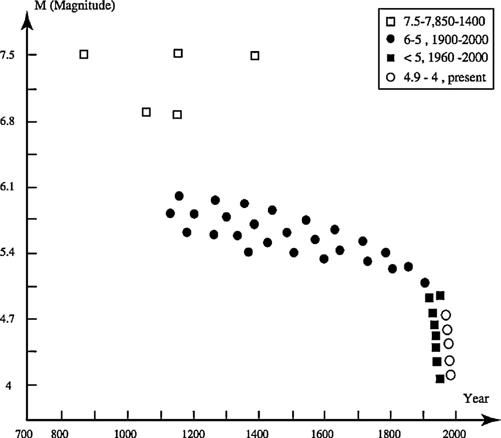
Seismicity evolution in time, from magnitude and age of recorded earthquakes.
Fig. 2. Évolution de la séismicité dans le temps, d’après la magnitude et l’ancienneté des tremblements de terre connus.
3 Seismic map of Syria
According to all parameters discussed above: movement rate, estimated from field data between less than 1 mm/year and 2.7–3.3 mm/year, Z value estimated at 0–0.25 cm/S2, relative seismic intensity measured in laboratory, oedometric measurements, an analysis of recent seismicity documented by the seismic network, and historical record, we have identified a number of seismic zones of corresponding seismic intensity (Table 1).
Calculated seismic parameters, corresponding seismic zones and their intensity.
Tableau 1 Paramètres séismiques calculés et zones séismiques correspondantes, avec leurs intensités respectives.
| MR mm/year | 0 | < 1 | 1 | 1.5 | 2 | 2.5 |
| Z cm/S2 | 0 | 0.05 | 0.1 | 0.15 | 0.2 | 0.25 |
| Seismic zone | 0 | 0–1 | 1–2A | 2A | 2B | 2C |
| Seismic intensity | None | Very low | Low | Middle-low | Middle | Moderate |
These zones are represented on a seismic map of Syria (Fig. 3) proposed here for the first time. This map divides Syria into five zones, each of which relates to a given seismic intensity value. Zone 1, in the western part of the country, corresponds to the highest seismic intensity risk, with most potential damage for the constructions, while the risk in zone 5 is lowest.
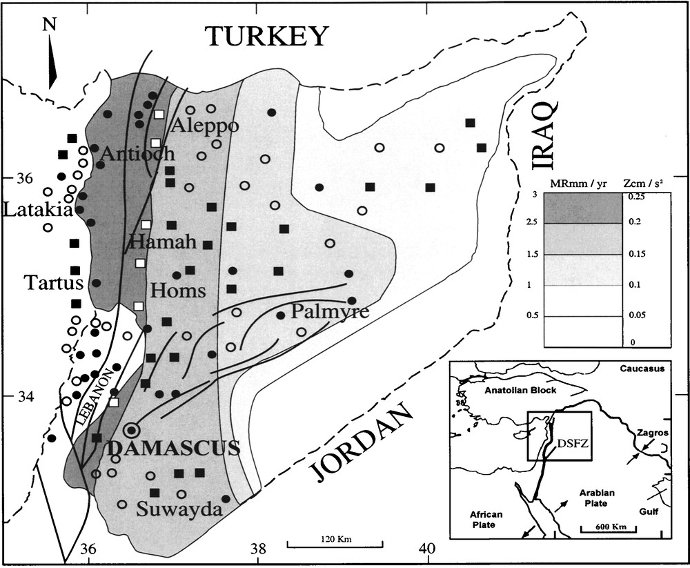
Seismic map of Syria, showing the five seismic zones, as well as the location of above 4-magnitude earthquakes. White square: M > 6; black circle: 5 < M < 6; black square: M < 5; white circle. M = 4,9–4.
Fig. 3. Carte séismique de la Syrie montrant les cinq zones séismiques et la distribution des séismes, avec une magnitude supérieure à 4. Carré blanc : M > 6 ; cercle noir : 5 < M < 6 ; carré noir : M < 5 ; cercle blanc : M = 4,9-4.
On the same figure, earthquake epicenters with a magnitude higher than 4 are indicated. They occur in the whole territory, but mostly in zones 1 and 2, where volcanic activity also occurs, or along the Damascus–Palmyra mountain chain. Only six earthquakes have a magnitude higher than 7.5–6.5 (in 749 at Yammouneh-Ghab with magnitude: 7.5–7, in 859 at Antioch with M: 7.5–7, in 1063 at Qalaat Hosn with M: 7–6.5, in 1157 at Apamea-Hama with M: 7.5–7, in 1170 at Missyaf with M: 7.5, in 1408 at Qalaat Blatnes, west of Aleppo, with M > 7.5), and even these remain controversial. Most recorded earthquakes in the 20th century have a magnitude less than 6. Out of 100 earthquakes in the region and offshore, 25% have a magnitude between 6–5, most of them less than 5. Altogether, the whole Syrian territory shows a moderate seismicity, compared to the north, Taurus–Zagros fault zone, or to the south, under the Indian Ocean expansion.
4 Seismicity and volcanism in Syria
As indicated above, most major seisms in Syria occur in two regions (Fig. 4): either within or close to the rift zone, along a north–south direction, or SW–NE oriented, along the Damascus–Palmyra mountain chain. This last domain does not contain any volcanic activity. Earthquakes in this region can only be caused by superficial deformation of the sedimentary cover.
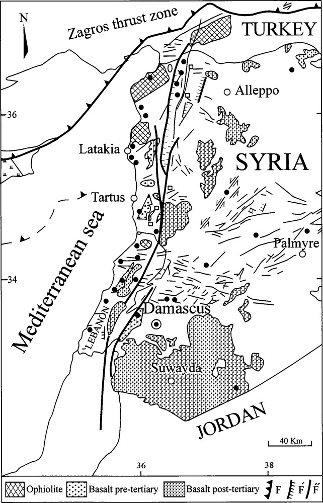
Regional tectonic map of Syria showing the rift structure, volcanism and distribution of major earthquakes epicenters (black circles: 5 < M < 7.5).
Fig. 4. Carte tectonique de la Syrie montrant la structure du rift, le volcanisme et la distribution des épicentres des séismes (cercles noirs) dont la magnitude est comprise entre 5 et 7,5.
Concerning the relation between seismicity and volcanism, petrological study from volcanic xenoliths has identified the existence of a hot spot (plume), under the Syrian rift [28,29]. In the earliest period of volcanic activity (Cretaceous), this plume started at the level of mantle garnet peridotite, leading to a marked explosive volcanism which, possibly improperly, has been interpreted as diatremes of very deep origin (“pseudokimberlites” [28]). It may be hypothesized that this type of volcanism did involve the major seismicity. In more recent time, the plume head tends to rise, while at the same time migrating towards the west. This was accompanied by a more effusive type of volcanism, associated to the moderate seismicity known in more recent times. The last eruption (10,000 years ago) occurred in the large volcanic massif at the South (Djabal Al Arab). With one exception, it can be seen on Fig. 4 that no major seism relates to this last eruption. This recent massif, by far the larger in Syria, seems to distantiate from the rift zone, at the difference, notably, of older Cretaceous volcanism.
In conclusion, seismicity, at the scale of the human observation, does not seem to be directly related to present-day volcanic activity. Most earthquakes are located on or near the sites of more ancient volcanoes, as if they were a reminiscence of this ancient volcanism. Others, along the Damascus–Palmyra mountain chain, are not at all related to any form of volcanism. They correspond most probably to superficial deformation, in response to fault movements at depth. Both sources tend to fade out with time, in line with the decrease of major seismic intensity which has occurred during the last millennium.
Acknowledgements
I would like to thank Professor Albert Jambon and co-workers for their support during my stay in Paris, as well as Claude Abrial for making superb drawings.