

1 Introduction
Spontaneous potential (SP) measurements have been used for years to study volcanic activity [15,40,41], to monitor subsurface fluid flows for hydrothermal [3–5,13,22,23,36] and hydrological applications [25,30,32–35], or as possible earthquake precursors [39]. SP anomalies have been explained mainly by eletrokinetic coupling between fluid flows through porous media and electrical polarization of the double layer located at the micro-scale as part of the pore-liquid interface [29,31].
Laboratory experiments [8,11,16,18,24,28] have, in the meantime, contributed to a better understanding of SP records. Precise downhole data analysis requires, in particular, core measurements in order to estimate the electrokinetic coupling coefficient relating electrical and hydrodynamic flow. Nevertheless, laboratory measurements are difficult to use to model field data as in situ conditions are often poorly known. As a result, data analysis is often subject to speculations, mostly due to the lack of information about the physical conditions at depth. A simultaneous downhole recording of key parameters (SP, fluid pressure, temperature, pH, Eh and electrical conductivity) is often required for a detailed evaluation of hydro-electrical subsurface effects, which provided the rationale for the design of a new tool.
Multi-Sensors Electrical Tool (MuSET) was built in the framework of the FP5 EC-funded “Advanced Logging Investigations of Aquifers in Coastal Environments” (ALIANCE project). ALIANCE aimed to develop and assess for end-users an integrated set of hydrogeological tools and methods. Groundwater resources management and mitigation of long-lasting pollution risks, with special attention to saltwater intrusion issues, were the main objectives of the project. For this, ALIANCE set up in situ experimental facilities and new downhole sensors, to obtain a more precise in situ fluid flow and transport description in endangered coastal reservoirs.
In this article, we focus on one of these new sensors called MuSET, which provides a simultaneous measurement of downhole SP and fluid parameters (p, T, pH, Eh, Cw). The main goal here is to point out the capacity of MuSET to identify several downhole sources of natural electrical currents and, in particular, its ability to investigate hydro-electrical coupling phenomena. After a rapid summary of electrical SP fundamentals, the new MuSET tool is described and possible applications are illustrated by in situ data recorded at two of the new field sites.
2 Methods
2.1 Spontaneous potential
SP corresponds to in situ electrical signals associated with charge polarization mechanisms occurring at depth. Two main sources are generally discussed. One source is electrokinetic coupling [2,32], which is controlled by the relative motion between the charged mineral surface and the excess of charges located in the electrical diffuse layer of the pore fluid [6]. In the shallow subsurface, the motion of fluids forced by a pressure gradient through a porous medium can generate electrokinetic effects. Amplifications due to the presence of a two-phase flow may also be considered [1,12,24], as surface conductivity effects tend to be enhanced by a reduction of the conducting volume. While the role of two-phase flow is still being discussed in the literature, Guichet et al. [8] have shown that the elektrokinetic effect tends to decrease when the water content is decreased.
The diffusion of ionic species creates another SP source associated with electrochemical coupling [20]. More precisely, the electrochemical potential is the sum of (1) liquid junction potential due to ionic movements at the boundary between two different electrolytes and (2) membrane potential related to the presence of clay. Redox potential might also contribute to the overall signal in the presence of metals or “appropriate” contaminants [25]. Both laboratory and field experiments suggest that electrokinetic potentials generated by fluid flows into porous geological materials are often the main source of SP signals.
Once diffusion processes are taken into account, the SP profiles provide an electrical signature of fluid flow in the subsurface or in the borehole. In particular, this method may help to determine zones either of infiltration, and water recharge, or of runoff.
2.2 Multi-Sensors Electrical Tool (MuSET) downhole tool
MuSET was designed in the framework of ALIANCE as a joint project between CNRS (Montpellier, France) and ALT (Redange, Luxembourg) in order to investigate downhole hydro-electrical coupling phenomena. The aim was to measure the downhole SP as a function of depth simultaneously with other sensors (p, T, pH, Eh, Cw) traditionally used to characterize fluid movements in boreholes penetrating the shallow subsurface. Simultaneous recording of fluid parameters may permit a control of the one involved in the analysis of surface electrical processes. Such a tool had never been built, although several experiments involving a single SP sensor were made in the KTB deep exploration hole [38].
With MuSET, the electrical spontaneous signal is measured by two unpolarizable electrodes, for example, one of them being located at the surface far from the borehole (distance > 10 meters) which reduces the possibility of measuring effects due only to the fluid in the borehole. MuSET is an extrapolated version of the ALT Idronaut hydrochemical downhole sensor, to which a standard unpolarizable Pb/PbCl2 electrode [27] with a resolution range of 0.5 μV (Fig. 1) has been added. This electrode is isolated from the metallic cable connected to the tool. The operating range of MuSET covers temperatures up to 70 °C and pressures up to 20 MPa. This sensor may be deployed either for the exploration of natural settings or during active experiments such as pumping tests.

MuSET is less than 2 m long and includes an unpolarizable “Petiau” electrode at the top, and a traditional set of hydrochemical sensors with the Idronaut array at the base.
MuSET est un outil de moins de 2 m de long qui possède une électrode non polarisable “Petiau” dans sa partie supérieure et un ensemble de capteurs hydrochimiques traditionnels à la base avec l’Idronaut.
3 Experimental results
3.1 Lavalette experimental site (Montpellier, France)
MuSET was first used at the Lavalette site, which is located 3 km to the northeast off-campus, on the outskirt of Montpellier (France). This site serves as a logistical and experimental base for tool development, testing and calibration. The Lavalette site is equipped with three nearby boreholes 70 to 100 m in depth, including a fully-cored one (LAV1). The holes are aligned along a north–south direction (Fig. 2). Below an 8- to 12-m-thick, irregular Holocene cover, the three boreholes cross-fractured marly limestone of Valanginian age (Fig. 2). The Quaternary sediments result from deposits of the nearby Lez River. The groundwater level is stable all year round at about 4 m depth.
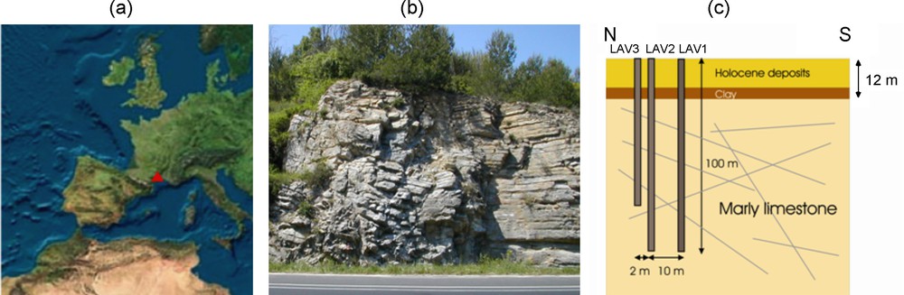
Lavalette site located near Montpellier (Languedoc, France); (a): location of the experimental site, as part of the Gulf of Lion shelf; (b): a nearby roadside outcrop of Valanginian marly limestone, 1 km away from the Lavalette site; (c): geometry of the Lavalette downhole array of boreholes, presented along a North–South cross-section.
Le site de Lavalette est localisé à proximité de Montpellier (Languedoc, France) ; (a) : positionnement du site expérimental faisant partie du Golf du Lion ; (b) : un affleurement des calcaires marneux du Valanginien le long d’une route, à quelques kilomètres du site de Lavalette ; (c) : positionnement des forages du site de Lavalette, présenté suivant une coupe nord–sud.
MuSET was deployed in LAV1 to document spontaneous electrical potentials in the absence of nearby active pumping. The analysis of MuSET records required a detailed subsurface characterization. To achieve this, an exhaustive geophysical and hydrological logging program [7,9] was conducted, including borehole wall images, electrical resistivity, spectral natural gamma (with total and U/Th/K profiles), full waveform acoustic velocities, fluid temperature and fluid electrical conductivity. The millimetre to centimetre scale structures, mostly fractures and bed boundaries, were described and oriented from logs and high-resolution images [19] respectively. Geophysical data were also used to characterize the penetrated lithology, to identify the presence of clays (or alteration) and to detect discontinuities at depth, such as fault zones. Finally, borehole fluid measurements (p, T, Eh, pH, Cw, SP) contributed to relate fluid movements to the structure.
In particular, the natural gamma record illustrates downhole variations in clay content between marl-rich and limestone layers of Valanginian age (Fig. 3), with imbricated high and low frequency downhole changes. The optical images confirm the presence of marly beds, mostly dipping 30 to 60° to the south-west (above 40.8 m), and to the south (below) (Fig. 3). From borehole wall images, open fractures crossing the borehole are identified and differentiated, either completely or partially filled with calcite (Fig. 3a). The dip angle and the dip direction of fractures are measured from each sinusoid. Although the analysis of these structural data documents large deformations for the Valanginian layer, the fractures do not show a preferential orientation. This is attributed to the complex geological structure in this area resulting from two main tectonic phases: the south–north Pyrenean compression, followed by a NW–SE Oligocene extension. Note that fractures appearing as open from borehole wall images are not necessarily hydraulically transmissive since they may be connected only in the very near vicinity of the borehole. Changes in borehole fluid measurements indicate the presence of fluid flows with the identification of a main transmissive zone close to 60 m depth. The SP record obtained in LAV1 (Fig. 3c; black curve) is found to almost perfectly overlay the natural gamma profile (Fig. 3c; green curve). This suggests that the presence of clay is responsible for most of the SP signal at Lavalette, related to membrane diffusion in the clay.
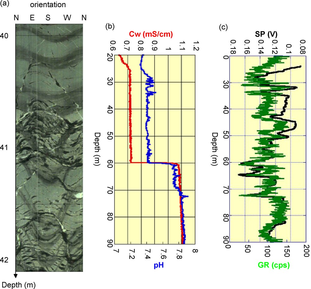
Data from the LAV1 corehole at Lavalette (Montpellier): (a): optical image of the borehole surface along a 2 m-long interval, with southwest dipping sedimentary fabrics at the top, and a faulted interval at the base. A south-dipping sedimentary structure is cut by later north-dipping fractures, with partial calcite infill. Clay-rich layers (dark) alternate with more calcite-rich intervals (lighter colour); (b): fluid measurements recorded by MuSET indicate fluid flow at 60 m depth; (c): spontaneous potential measured with MuSET (black curve), compared to a total natural gamma profile (green curve).
Données enregistrées à Lavalette dans le forage carotté LAV1 (Montpellier) : (a) : image optique de la paroi du forage sur une distance de 2 m, avec une fabrique sédimentaire à pendage sud-ouest dans la partie supérieure et une zone fracturée à la base. Une couche sédimentaire à pendage sud est coupée par une fracture à pendage nord, colmatée par de la calcite. Les niveaux marneux (couleur sombre) alternent avec des niveaux plus riches en calcite (couleur plus claire) ; (b) : les mesures relatives au fluide, enregistrées par MuSET indiquent un écoulement à 60 m de profondeur ; (c) : le potentiel spontané mesuré avec MuSET (courbe noire) comparé au profil de gamma nature total (courbe verte).
3.2 “Salt-intrusion” site near Campos (Mallorca, Spain)
The ALIANCE saline wedge experimental site is located at Ses Sitjoles, 8 km southwest of the city of Campos, in the southeastern part of the island of Mallorca (Fig. 4a,b), and 6 km from the Mediterranean coast. Subsurface tomography from surface electrical investigations performed in this area indicate that seawater runs more than 15 km inland, resulting in an important pollution of the shallow groundwater. The experimental site is now equipped with 12 holes, all 100 m in depth, including 7 fully-cored boreholes, distributed over a nearly perfect 100-m side square (Fig. 4c). The cores have been fully characterized in petrological, petrophysical, hydrological and geochemical terms, especially a chosen “reference hole” (MC2) located at the southern tip of the site [14,21]. All boreholes cross the Miocene carbonate platform of South-East Mallorca. The structure is rather classical for reef deposits, with shallow platform deposits near the top (surface to 28 m in MC8), reef constructions below (28 to 63 m), and slope deposits underneath (63 m to bottom). The groundwater table lies at a depth of ∼ 37 m, which corresponds to a meter above the present sea level at the coast.
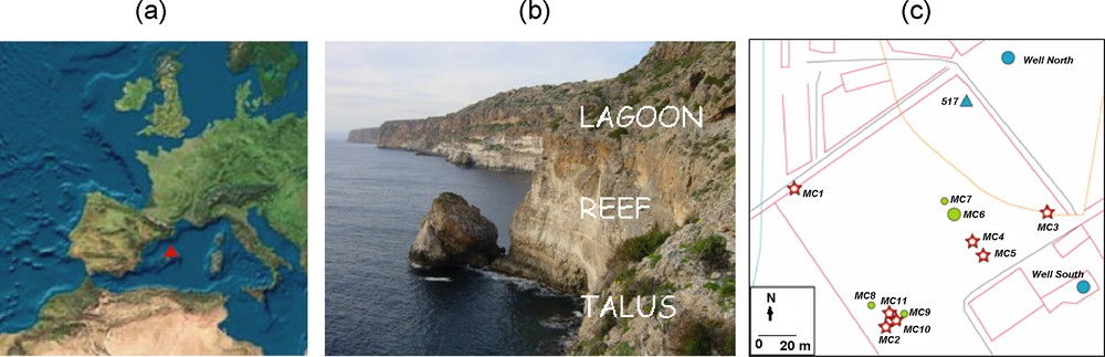
The ALIANCE saline wedge experimental site at Ses Sitjoles (SE Mallorca, Spain); (a): Balearic Islands; (b): outcrop of reefal lithofacies at the Cabo Blanco cliff, 15 km west of the Ses Sitjoles site; (c): map of the Ses Sitjoles site. Fully-cored and destructive boreholes are respectively represented with red stars and green circles. The blue circles and triangle correspond to pre-existing holes.
Site expérimental avec intrusion d’ALIANCE saline wedge de Ses Sitjoles (Sud-Est de Majorque, Espagne); (a) : Iles Baléares ; (b) : affleurement des faciès récifaux le long de la falaise de Capo Blanco, à 15 km à l’ouest du site de Ses Sitjoles ; (c) : carte du site de Ses Sitjoles. Les forages carottés et destructifs sont respectivement représentés par des étoiles rouges et des cercles verts. Les cercles bleus et les triangles correspondent à des forages préexistants.
While a detailed description of the site was obtained from cores and by downhole geophysical methods, the fluid conductivity profiles confirm the presence of a saline wedge at depth (Fig. 5b). The top of the transition zone between fresh and saline water is located in MC8 at ∼ 63 m depth, precisely at the reef to slope transition. Active pumping in the fresh water body for agricultural and domestic reasons appears to further enhance the saline intrusion into the southeastern part of Mallorca. Flowmeter tests were also used to identify potential vertical flow in the holes [17,37]. In particular, a heat-pulse flowmeter [10] was deployed in MC8, under ambient and stimulated (pumping) regime [26], at several measurement points along the borehole (Fig. 5c). These measurements demonstrate the existence of an upward vertical flow, ranging from 0.4 to 0.6 mm/s, mostly from 57 m to 45 m depth. The flow is found to be relatively constant between 57 m and 45 m. This vertical flow may be related to the connection, within the vertical borehole, between horizontal fluid flow in the freshwater zone due to nearby agricultural pumping (at ∼ 100 m scale).
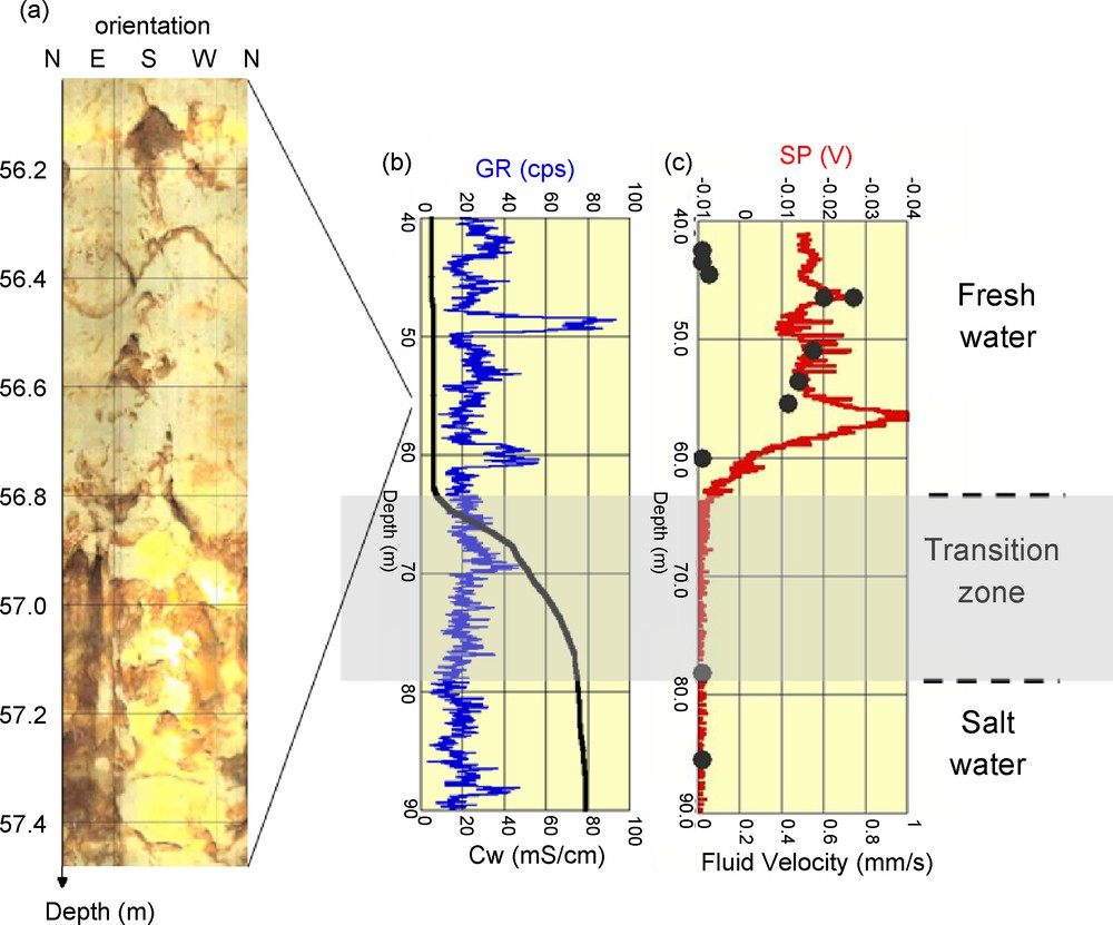
Downhole measurements and images from the MC8 hole near Campos; (a): optical image of the borehole surface along a 1.5 m-long interval, with a karstified zone at the base; (b): fluid conductivity from MuSET (black curve) with the natural gamma profile (blue curve); (c): spontaneous potential from MuSET (red curve), compared to local heat-pulse flowmeter data (black dots).
Mesures en forages et images de parois provenant du forage MC8 à proximité de Campos ; (a) : image optique de la paroi du forage sur un intervalle de 1,5 m de long, avec une zone karstifiée à la base ; (b) : conductivité du fluide enregistrée avec MuSET (courbe noire) avec le profil de gamma naturel (courbe bleue) ; (c) : potentiel spontané enregistré avec MuSET (courbe rouge), comparé aux données locales de débimètre à flux de chaleur (points noirs).
Within the Ses Sitjoles boreholes, the geological structure is particularly well described from millimetre-scale optical images of the borehole surface, recorded in water for the fluid-saturated section, or in air through the vadose zone. While mineralised zones appear to correspond to past/present fluid interfaces, several karstified intervals are found to dominate the overall transmissivity of the structure (Fig. 5a). In the fluid-saturated section, the natural gamma counts are very low, except for two zones at 48 and 60 m depth (Fig. 5b). This signal is related exclusively to changes in U content, with high U concentrations (and low Th/U ratios) associated with the presence of organic matter and the presence of coralline algae.
The SP profile obtained in borehole MC8 is presented next to heat-pulse flowmeter results (Fig. 5c). In the absence of clays for the fluid-saturated section of this geological setting, the absence of fit between the SP and natural gamma profiles exclude here a contribution of the membrane component to the natural electrical signal. A good correlation between the SP signal and the flowmeter data between depths of 55 m and 45 m is observed. This corresponds to the vertical flow zone detected with the flowmeter test, indicating a strong hydro-electrical coupling at these locations.
However, the SP profile does not match the heat-pulse flowmeter data at 57 m depth, above 45 m and just below 60 m depth. This difference might be explained by horizontal fluid flows in the freshwater zone. At 57 m depth, while the heat-pulse flowmeter is indicating a relatively constant vertical flow, the peak observed in the SP signal suggests an additional horizontal component associated to a karstified zone (Fig. 5a). Above 45 m depth, while the heat-pulse flowmeter describes an absence of vertical fluid flow in the hole, the SP response appears to point to a different process and horizontal flow in the hole. Below 60 m, Fickian diffusion associated with a “liquid-junction” component in the transition zone between fresh (above) and saline water (below) is a candidate to explain the recorded electrical signal, while the heat-pulse shows the local absence of vertical flow.
4 Conclusion and perspectives
A new downhole tool (MuSET) for in situ SP measurements is described here. The new device is deployed jointly with traditional fluid pressure, temperature, pH and electrical conductivity sensors. Downhole records obtained from two different geological settings demonstrate the ability of this new SP sensor to identify and differentiate signals originating from in situ electrokinetic and electrochemical effects. In particular, these data suggest that MuSET may be used as a very precise “electrical flowmeter” sensitive to both vertical and horizontal fluid movements in a vertical borehole. To do this, the diffusion (membrane and liquid-junction) components must first be taken into account. A further step for the analysis of downhole subsurface processes will be to set-up permanent observatories equipped with similar SP electrodes. This would provide permanent downhole arrays for time-lapse imaging of either fluid flows or physicochemical processes, such as those detected in the saltwater-wedge transition zone of coastal reservoirs.
Acknowledgements
The development of MuSET was funded as part of the FP5 European Community project “ALIANCE” (contract EVK-2001-00039) and technically conducted by ALT (Luxembourg). Financial support for field experiments was also provided by CNRS in the context of the “ORE H+” (hplus.ore.fr), a network of institutions and subsurface observatories for hydrogeological research. Concha Gonzalez and Alfredo Baron at the “Conselleria de Medi Ambient” (Balearic Islands government) are thanked for sustained assistance through ALIANCE and beyond, largely contributing to developing the Mallorcan experimental site at Ses Sitjoles.