

1 Introduction
New Caledonia, a French archipelago in the Southwest Pacific, is located at the eastern border of the Australian plate, several hundred (100 to 500) km from this plate's subduction under the Vanuatu arc. This location renders New Caledonia exposed to tsunamis triggered by seismic or volcanic induced submarine landslides that can affect the islands within half an hour (Ioualalen and Pelletier, 2006). The New Caledonian archipelago is composed of a main island (Grande-Terre), the three Loyalty Islands (Ouvéa, Lifou and Maré) which are located on the eastern side of Grande-Terre, the Belep Islands on its northern side, and the Île-des-Pins Island on its southern side. Grande-Terre is surrounded by the second largest coral reef barrier in the world. The archipelago is populated by 231,000 inhabitants. The eastern coasts of Grande-Terre and the Loyalty Islands are occupied by more than 21,000 people, mainly composed of Melanesian tribal communities.
The event that occurred at the Loyalty Islands on 28 March 1875 is the only recorded tsunami of local origin that has caused casualties in the territory (Louat and Baldassari, 1989). Missionaries at the time reported the death of 25 people following the arrival of a wave train on the eastern coast of Lifou 20 min after the earthquake (Mw ≈ 7.6, located in the southern subduction zone of Vanuatu (Ioualalen and Pelletier, 2006)). This event and a few others are documented in the literature: an event which possibly occurred in northern Ouvéa in 1951 (Louat and Baldassari, 1989) and three events on the coast of Grande-Terre in 1931 and 1934 (Soloviev and Go, 1974). Listed in a preliminary tsunami risk evaluation report (Pillet and Pelletier, 2005), these aforementioned events are the only ones that have been previously documented for New Caledonia.
Catalogs of tsunami events in neighboring territories describe the impact of trans-oceanic tsunamis in Solomon (Everingham, 1977), Vanuatu (Louat and Baldassari, 1989), Fiji (Everingham, 1987; Berkman et al., 1961), New Zealand (Power, 2007), etc. These events that affected the region leave one to believe that they could have affected the Caledonian coasts as well, without being formally recorded as doing so.
In fact, in order to establish an effective alert system, it is indispensable to precisely determine the impact of previous local, regional, and trans-oceanic tsunamis on the territory (Courteau, 2007), notably to define the threshold for an alert and for the evacuation of exposed populations. Moreover, a better understanding of tsunami observations in this territory would allow one to better understand the role of the barrier reef and its channels in the spatial repartition of the areas exposed to the tsunami hazard (Roger et al., 2010).
For this reason, in 2008, field research was mandated by the French Secretary of State for Overseas Territories, co-financed by the UNESCO French commission, with logistical support from the French Civil Security and the High Commission of the French Republic in New Caledonia, in order to establish an exhaustive list of the events which had an impact on the territory. Thus, field research was conducted in New Caledonia (Grande-Terre, Loyalty Islands, and Île des Pins) over 12 weeks to collect verbal witness accounts, as well as any existing written accounts, of tsunamis. This article presents the methodology and results from the data collection and public inquiry, as well as discusses its limitations and the means needed to ameliorate scientific knowledge and mitigation of the tsunami risk in New Caledonia.
2 Methods
2.1 Archive research
A list of tsunamis that potentially had an impact on the territory, as well as a list of potential tsunamigenic earthquakes, was constructed from previous catalogs (Dunbar et al., 2008; Heck, 1947; Louat and Baldassari, 1989; Soloviev and Go, 1974). This list included local earthquakes of magnitudes greater than Mw = 7 measured in a 600 km radius around New Caledonia (Dunbar et al., 2008), potentially capable of producing local tsunamis. This magnitude was selected to limit the number of probable events during this preliminary field investigation. Additionally, no earthquake of lower magnitude is known to have triggerred a tsunami impacting New Caledonia. Far field trans-Pacific tsunamis were also considered. This list allowed for a more targeted archive search of different written sources. The newspapers available at the time of the event were also consulted for a time period beginning the day of the event until approximately ten days following the event. The newspapers include La France Australe (1889–1979), Le Bulletin du Commerce (1902–1957) and Les Nouvelles Calédoniennes (since 1973). This list of potential or previously observed tsunamis, in addition to meteorological archives (MFNC, 2008), was used to validate witness testimonies, and notably to exclude observations during cyclonic periods.
2.2 Collection of previously-recorded testimonies
Testimonies of recent and past events that were collected over the last few years by the UMR Géoazur-geology and geophysical laboratory of the Institut de recherche pour le développement (IRD) of Nouméa were also used. These testimonies focus on the southern lagoon of Nouméa, the eastern coast of Grande-Terre and the Loyalty Islands. These testimonies were obtained thanks to the establishment of a prevention program in 2003 that was included in a project focusing on the modeling of the 1875 tsunami in Lifou (Ioualalen and Pelletier, 2006) and which sensitized the population to tsunamis. Moreover, the deadly tsunami of December 2004 created a certain awareness of the potential devastating and deadly consequences of a tsunami. This awareness caused significant worrying among the people during the series of earthquakes that occurred in January 2005 in Nouméa. Since 2005, the Civil Security, in conjunction with the coastal communities, has been implementing an alert system using sirens. To this effect, an awareness campaign was established in the Provinces and at City Halls in May and June 2007 by the Civil Security and the IRD. The awareness was also reinforced by a warning issued by the PTWC and subsequently by the Civil Security following the 2 April 2007 Solomon tsunami. Due to the succession of events since 2003, the collection of several significant witness testimonies has been possible.
2.3 Collection of witness testimonies during the investigation from 31 March to 15 June 2008
The investigation carried out a call for witnesses in the territory during the entire campaign duration. Several media (television, newspapers and radio) also relayed the message and informed the coastal communities of the investigator's presence in the tribes. Administrations at the local tribal level, governmental and state level all participated in the call for witnesses by broadcasting the message in public locations (city halls, administrative subdivisions, local Customary Councils, police stations, fire stations, clinics, etc.) so that it would be visible to the greatest number of people.
The investigator (A.S.) assembled all observations related to the arrival of the tsunami, such as those relating to: asynchronies in tidal variation of the sea level, drops of sea level out of the foreshore at non-cyclonic periods, the observation of whirlpools, tidal bores, ascending river currents or inversely brutal purges, the rupture of moors, etc. The investigation focused its attention on the sectors potentially being the most exposed: the Loyalty Islands, the eastern coast of Grande-Terre and the Île-des-Pins. The western coast was not a focus in the investigation since it is not facing the pit of Vanuatu and the Pacific, and therefore is exposed very minimally to the tsunami hazard. Moreover, there have not been any witness accounts from anyone on this coast.
The field investigation concentrated on individual meetings and discussions with the elders who lived along the shores at the time of past events. Only people who had a certain knowledge of the sea were considered: people living by the sea and/or having a regular activity on the shore (fishermen, harpoon fishermen, sailors, scuba divers), which is to say most of the coastal tribal communities.
In total, 92 significant testimonies were collected on the East coast of Grande-Terre and in the Loyalty Islands (Ouvéa, Lifou and Maré). For a testimony to be considered significant, it had to categorically affirm the occurrence of an unusual phenomenon which could be scientifically explained and could be linked directly to a tsunami event, even if the witness could not specify the precise date/time that it happened. The denial of an unusual event's occurrence on a specific date was also considered when witnesses mentioned that “if something happened, I would have noticed it”.
2.4 Cross-checking of information
After the collection of testimonies from the field investigation was completed, the observations were then validated, or not, by crosschecking them against the list of possible tsunamis (see section 2.1). Not included in the list were local tsunamis without major seismic activity. Given that the majority of witnesses described the date of the event as occurring around the time of another event (births, deaths, cyclone, etc.), in order to more precisely determine the date, archives from various sources (newspapers, local archbishops, Customary and Common Law Public Records Offices, etc.) were consulted. Additionally, certain testimonies orientated the investigators in their research towards particular time points in the archives, which helped complete the oral observation testimonies with written support from the archives.
3 Results
The recorded tsunamis are classified depending on the location of their source. Hours are expressed in local time (GMT + 11). Each event has its source located on Fig. 1 when it could be identified.
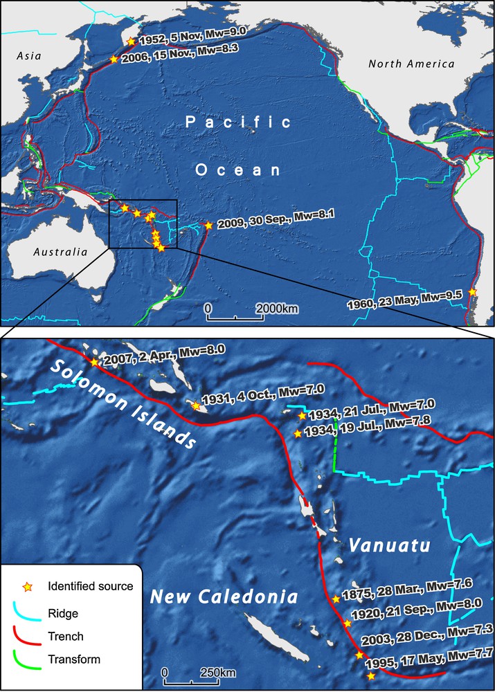
Location of tsunami sources identified as impacting New Caledonia in the past (dates in local time).
Localisation des sources de tsunamis identifiés comme ayant eu un impact sur la Nouvelle-Calédonie dans le passé (horaires locaux).
3.1 Local Tsunamis (sources a few hundred km away, in the southern part of Vanuatu subduction zone)
3.1.1 28 March 1875 (testimonies and literature)
A significant earthquake of an undetermined magnitude struck the Loyalty Islands at 11 pm. Twenty minutes later, a powerful tsunami attacked the coast of Lifou (Ioualalen and Pelletier, 2006). This destructive event was recorded by missionaries at Lifou.
The tsunami caused the death of 25 people on the Southeast coast of Lifou (Fig. 2A). The areas the most affected were the villages of Thoth and Mou around the Cap des Pins (Fig. 2B). Important waves are also noticed at Luengoni and Wé in the Bay of Chateaubriand. The New Caledonian newspaper Le Moniteur dated 28 April 1875 reports missionary witness accounts that describe the series of events that occurred. The testimonies and letters are reported in extenso by Louat (Louat, 1988) and Louat and Baldassari (Louat and Baldassari, 1989). The oral transmission of events gives evidence even today of some areas reached by the waves. A minimal runup of 2.5 m is reported in Mou by four descendants of different families affected by the tsunami (Ephrèm N., 87 y.o., André L., 50, Jules H., 73, and the Lossi tribal area's High Chief, Evanesié Boula, ∼50). The ruins of affected buildings remain on-site (Chief's hut, temple, located on Fig. 2C, photograph of the ruins of the temple on Fig. 2D). The limits of inundation could not be reconstituted.
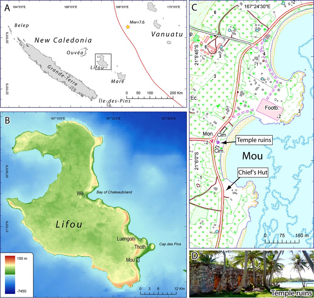
Areas of Lifou affected by the 1875 tsunami (B: data from Direction des infrastructures, de la topographie et des transports terrestres (DITTT), C: map from DITTT, numbers with dots describe the elevation, D: photograph by A. Sahal).
Lieux de Lifou affectés par le tsunami de 1875 (B : données Direction des infrastructures, de la topographie et des transports terrestres (DITTT), C : fond de carte DITTT, valeurs chiffrées correspondant à des points cotés, D : photographie A. Sahal).
Numerical modeling, based on detailed bathymetry of the island's coastal zones (Pelletier et al., 2004) and on an earthquake having a potential magnitude of Mw = 7.6 in the southern subduction zone of Vanuatu, reproduced the observations (Ioualalen and Pelletier, 2006). The seismic source in this scenario is located about 180 km north-east of Lifou (Fig. 2A).
3.1.2 21 September 1920 (public records and testimonies)
An earthquake of Mw = 8.0 is recorded between Anatom (Vanuatu) and Maré at 1:39 am. The quake is felt in New Caledonia (Nouméa, La Foa, Farino, Canala, Ouvéa, etc., La France Australe dated 21 September 1920, located on Fig. 3).
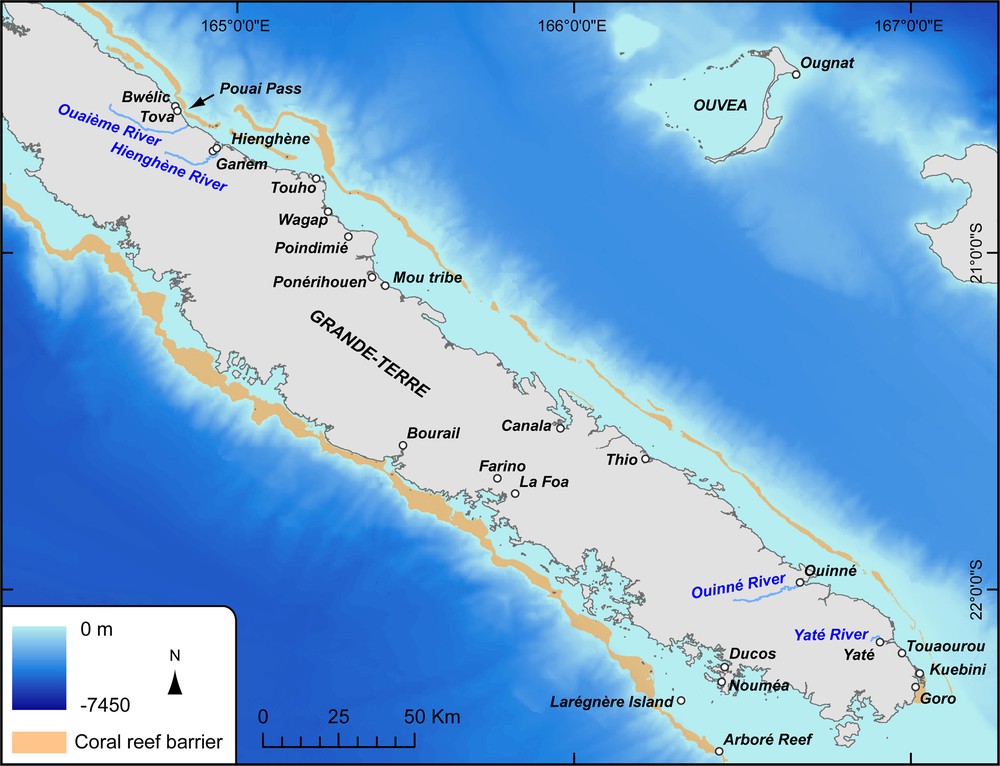
Areas of Grande-Terre and Ouvéa discussed in the text (DITTT data).
Localités de Grande-Terre et Ouvéa citées dans le texte (données DITTT).
On this fair weathered day, a tsunami flooded Ougnat, northern Ouvéa, destructing crops. No precise timing could be reported. The same day, one of the flood victims gave birth prematurely to a baby she named Waakôiô (which means “tidal wave”), because the stress of the event triggered her premature labor (reported by Aizik W., 72 and Wageno J., 90, confirmed by public records).
3.1.3 17 May 1995 (Police report)
A normal fault-type earthquake of Mw = 7.7 is recorded at 7:12 am, south-southeast of Walpole Island (300 km southeast of Maré and Nouméa) on the plunging Pacific plate at the southern tip of Vanuatu subduction zone. The police of Maré reports that the sea is very agitated in the Southwest of the island.
In Vanuatu, 1 hr 30 later, between 8:30 am and 9 am, unusually high sea levels are reported in Aneytum Island and Port Vila in Efate (Lardy, 1995). The base of bungalows of Erakor islet and the restaurant at Pango road were reached by the sea. The amplitude is estimated to be 1.5 m. At the entry of the First Lagoon, witnesses notice that the ocean is agitated and stays at a high level during a 10 to 15 min period. No witness testimonies or other information was found during the field investigation concerning New Caledonia.
3.1.4 28 December 2003 (Police report)
A thrust fault-type earthquake of Mw = 7.3 is recorded at the southern part of the Vanuatu arc, 185 km to the east-southeast of Maré at 3:01 am. The Maré police reports that the sea is agitated. No observations or witness testimonies were recorded or found during the field investigation to clarify the police observations. This earthquake is part of a series of earthquakes that occurred from 25 December 2003 to 5 January 2004.
3.2 Regional Tsunamis (sources in Solomon and Northern Vanuatu subduction zones)
3.2.1 4 October 1931 (newspaper archives)
An earthquake of Mw = 7.0 is recorded at the Solomon Islands (San Cristobal) at 6:13 am.
At 2 hr 15 post-earthquake (Soloviev and Go, 1974), the first significant wave goes up the Hienghène River reaching 7 km inland. Alternating upstream and downstream currents are observed every 5 min. On the shore, the tide rapidly withdraws, then returns to normal (Bulletin du Commerce dated 10 October 1931), and “agitated and noisy” waves are noticed (Soloviev and Go, 1974). The water, which looks turbid, reaches 1.2 m above normal tide. Locally, a wave of 1.5 m high is observed along the river's banks. Witnesses observe an ebb and flow with a period of 20–30 min (10–15 min/phenomenon). Maximal oscillations are observed between 8:30 am and noon. The tsunami ends around 2 pm. Boats are overturned, the seawall is destroyed, but no loss of human life is reported.
3.2.2 19 July 1934 (newspaper archives, no witness encountered)
An earthquake of Mw = 7.8 is recorded in the northern part of the Vanuatu arc (East Solomon Islands, Vanikoro) at 6:40 am.
At 1 hr 20 post-earthquake, the ebb and flow movements which are comparable to the standard tide levels occur approximately every 10 min in Hienghène and Touho. The oscillations are estimated between 1.2 m and 1.3 m (Kellar, 1935 in (Soloviev and Go, 1974)), and last from 8 am to 2 pm (La France Australe dated 21 and 24 July 1934, Bulletin du Commerce dated 25 July 1934). The weather was good. No loss of materials or human life is reported.
3.2.3 21–22 July 1934 (newspaper archives, no witness encountered)
An earthquake of Mw = 7.0 is recorded in the northern part of the Vanuatu arc (East Solomon Islands, Santa Cruz) at 5:18 pm on 21 July.
Two-hour post-earthquake, “ebb and flow movements, stronger, but not as prolonged as those from the 19 th [of July]” are noticed at Hienghène between 7 and 8 pm. Some people notice a “low tide” of a 20–30 cm amplitude every 5 to 10 min. At the Thio wharf, around 8 pm, it was noticed that the tide, at a low point, climbed to normal levels, only to withdraw immediately. In Poindimié, the same phenomenon occurred between 8 and 8:30 pm. It lasted 30 min and was accompanied by a “loud noise”. Lastly, at Touho around 8 pm, ebb and flow movements of a “stronger, yet shorter duration [than in Thio and Poindimié]” were noted (La France Australe dated 23 and 24 July 1934, Bulletin du Commerce dated 25 July 1934). This event happened on a fair-weathered day.
On the 22nd, in Magenta Bay, close to Nouméa, the sea level rises, and then quickly retreats 3–4 m alternately every 10 min, over a 45 min time period during an ebb tide (Kellar, 1935 in (Soloviev and Go, 1974)). No loss of material or human life is reported.
3.2.4 2 April 2007 (18 testimonies)
An earthquake of Mw = 8.0 is recorded on the Solomon Islands arc (Gizo peninsula, New Georgia Group) at 7:39 am and a deadly tsunami hit the coast of Gizo killing 52 people (Fritz and Kalligeris, 2008). A tsunami warning was issued by the PTWC and an alert from the Civil Security in New Caledonia requested that the populations along the shores of the Loyalty Islands and the eastern coast of Grande-Terre evacuate to higher ground.
Three-hour post-earthquake, an unusual, very low tide is noticed around 11–12 am on La Ouaième by the cable-car-ferry driver (the ferry touches the river bed) and in Hienghène (nine different witnesses). Similar observations are reported along the coast (Fig. 4).
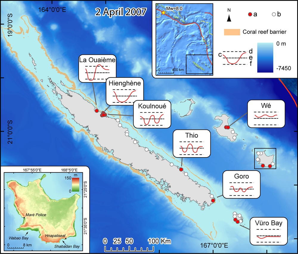
Approximate variations in sea level on 2 April 2007 from 10:30 am to 2:00 pm as described by the witnesses (a: record, b: deny, c: sea level variation during approx. 2 hr, d: high tide level, e: mid sea level, f: low tide level).
Approximation des variations du niveau marin le 2 Avril 2007 entre 10:30 et 14:00, telles que décrites par les témoins (a : anomalie, b : absence d’anomalie, c : variation pendant env. 2 h., d : marée haute, e : niveau moyen, f : marée basse).
At the bay of the Ouinné, at 11:35 am, a witness (André Puech) observes an abnormal low tide with respect to the usual one and sees eddies at the mouth of the river between 11:35 am and noon. The tide gauge of Nouméa indicates an elevation in the order of 5 cm at 11:40 am. The abnormal signal is recorded from 10:50 to 12:20 am in Nouméa (Service hydrologique de la marine, Mission océanographique du Pacifique, Base hydrographique de Nouvelle-Calédonie).
The witnesses are mostly fishermen, at sea or on shore, and people watching the sea from higher grounds. Their age, a summary of their observations as well as their locations are indicated on Table 1.
Description des témoins et résumé de leurs observations pendant le tsunami du 2 Avril 2007.
| ID | Surname Name | Age | Information | Area | Observation | Y | X | Runup |
| 1 | O. Mr | 30–50 | Cable car-ferry driver on the Ouaième | Hienghène | 2 m high purge / elevation + 0.8 m | 164,8505 | −20,6256 | 0.80 |
| 3 | B. Thierry | 30–40 | Scuba diving instructor | Hienghène | Recede reaching Pura, 20 min period | 164,9840 | −20,6872 | |
| 4 | L. Marc | 25–30 | Scuba diver | Hienghène | Recede reaching Pura, back to normal, similar recede, ends at 12 pm | 164,9860 | −20,6882 | |
| 5 | C. Henry | 30–50 | Fisherman, offshore | Hienghène | 11 am, recede during 30 min, tuna jumping out of water all around, slower refill, 2 cycles | 164,9610 | −20,6632 | |
| 6 | D. Gina | 25 | Waitress @ Hienghène's wharf | Hienghène | Recede reaching −0.4 (measured) during 15 min, all boats on river bed | 164,9450 | −20,6897 | |
| 7 | D. Benjamin | 30–50 | Hienghène | From high ground, sea comes up the river, down to the Sphinx, up again, period 10 min, eddies, mud along the banks, eddies | 164,9440 | −20,6826 | ||
| 8 | N. Joachim | 50–60 | Restaurant and Hotel owner | Hienghène | On the Hienghène bridge, mud along the banks, 11:30 am: low tide, 12:45 pm: back to normal | 164,9447 | −20,6958 | |
| 8b | N. Mrs | 40–50 | Hienghène | 11 AM, very quick purge - > Pura, h tide 5 min later | 164,9447 | −20,6958 | ||
| 9 | P. Prosper | 30–35 | Fireman in Hienghène | Hienghène | Broadcasted the alert to the people of Coulnoué, saw recedes and elevations but no flood | 164,9580 | −20,6843 | |
| 23 | Old woman @ Camping | 69 | Ponérihouen | Nothing | 165,4040 | −21,0401 | ||
| 24 | Oldest woman of Bâ tribe | 80 | Houailou | Nothing | 165,5539 | −21,1946 | ||
| 25 | Woman of Kua tribe | 82 | Houailou | Nothing | 165,7690 | −21,3347 | ||
| 27 | K. Sylvestre | 65 | Thio | Nothing | 166,2388 | −21,6023 | ||
| 28 | N. Anicet | 65 | Thio | Nothing | 166,4935 | −21,7961 | ||
| 31 | K. Ambroise | 52 | Thio | Quick drop at 11:20 am 2 switches during 20 min each | 166,4059 | −21,7040 | ||
| 34 | A. Valentin | 77 | Yaté | Swelling, then recede around 10:30 am, 2–3 successions of 20–30 min | 167,0177 | −22,2866 | ||
| 35 | A. Antoine | 75 | Yaté | Nothing | 166,9682 | −22,1824 | ||
| 37 | D. Jean-Rock | ∼60 | Île-des-Pins | Nothing | 167,5078 | −22,6594 | ||
| 38 | N. Eric | ∼40 | Île-des-Pins | Nothing | 167,4288 | −22,6287 | ||
| 39 | N. Boniface | ∼40 | Île-des-Pins | Around 2–2:30 pm, sees a 40 cm recede in 15 min, then back to normal | 167,4288 | −22,6327 | ||
| 40 | V. Philippe | 48 | Île-des-Pins | Around 10:30–11 am, sees a 10 cm elevation during 20–30 min | 167,4941 | −22,6734 | ||
| 43 | O. Joachim | ∼55 | Île-des-Pins | Nothing | 167,5214 | −22,5776 | ||
| 44 | B. Raphaëla | 84 | Île-des-Pins | Nothing | 167,4883 | −22,6684 | ||
| 45 | ∼40 | Meridien Hotel director | Île-des-Pins | Nothing from 10 to 11:10 am | 167,5179 | −22,5780 | ||
| 47 | A. Marcelin | 71 | Île-des-Pins | Nothing | 167,4250 | −22,5882 | ||
| 53 | 3 old women | Île-des-Pins | Nothing | 167,4899 | −22,6688 | |||
| 66 | D.Mr | ∼45 | Lifou | 10 H 30, −0.4 | 167,2630 | −20,9147 | ||
| 67 | B. Evanesié | ∼50 | Lossi area High chief | Lifou | 9 H 30, −1.5 | 167,2650 | −20,9160 | |
| 68 | M. Edmond | 30 | Lifou | 9 H 30, −1 m | 167,3780 | −21,0073 | ||
| 69 | U. Koel | 28 | Lifou | Nothing | 167,3780 | −21,0049 | ||
| 74 | M. David | ∼50 | Maré | Around 10 AM, 1m. recede (3 m far) in 3 min, back, 2nd recede of 1.5 m, sees ∼10 waves going NW direction | 167,9480 | −21,6265 | ||
| 75 | B. Damas | 49 | Official guide for Shabadran | Maré | On 3 April, sees an area where all trees are bent on the floor, oriented south-west, parallel to the coast on his way to Shabadran | 168,0780 | −21,6332 | 2,00 |
| 78 | W. Waboutche | 68 | Maré | Nothing | 167,9010 | −21,3962 | ||
| 79 | 6 elders | Maré, Ro | Nothing | 167,8640 | −21,3921 | |||
| 80 | B. Lakurine | 86 | Kurile Tribe Chief | Maré | Nothing | 168,1070 | −21,5828 | |
| 81 | Petit Chef HMAE | ∼80 | Hmae Tribe Chief | Maré | Nothing | 167,8470 | −21,5080 | |
| 82 | 4 elders | 80 | Living along the coasts | Maré | Nothing | 167,8510 | −21,5186 |
It is to be noted that the effect of the tsunami decreases from the northwest to the southeast, except in Maré, where a 2 m runup is assumed: trees were found lying in the western direction 2 m high the day after the event occurred by a local guide who frequented the area (southeast Maré, close to Hnapaliseal) daily. In southwest Maré, on the day the event occurred, another witness reported high waves coming from the east, and notices a recede of the sea level reaching −1.5 m. The contrast between the waves coming from the east that flooded Maré and the those having little impact along the east coast of Grande-Terre can be explained by the tsunami losing its energy between Grande-Terre and the Loyalty Island, where the seabed is less deep, and by the diffraction of the wave trains around east Maré.
The Port Vila tide gauge records an elevation of 11 cm at 10:51 am. No loss of materials or human life is reported in New Caledonia and Vanuatu.
3.3 Transoceanic tsunamis
3.3.1 5 November 1952 (newspaper archives)
An earthquake of Mw = 9.0 is recorded in Kamchatka (Russia) at 3:58 am.
Twelve-hour post-earthquake, around 4 pm, “enormous eddies” are noticed in the mouth of the Yaté River. “Very violent” ascending and descending currents spaced 15 min apart are seen with a water level variation increasing up to 2 m, and then diminishing up until 8 pm. It is noticed that fish are jumping out of the water. On the night of the 7th, the water disturbance is still present: whirlpools, ascending and descending currents spaced 45 min apart, water level variation of 0.8 to 1 m crest to trough are noticed (La France Australe dated 10 November 1952, note of R.T. de Laubarede). Similar events are noticed along the coast south of the Yaté River at Touaourou and Kuebini (Fig. 3). Strong currents and large amounts of dead fish are noticed further north in the N’Goye region (Bulletin du Commerce dated 8 and 11 November 1952).
3.3.2 23 May 1960 (newspaper archives)
An earthquake of Mw = 9.5 is recorded in southern Chile at 6:11 am.
“Very strong waves” and “extremely violent currents” touch the west coast of New Caledonia. “The roads by the shore are submerged”. The southeast coast (Yaté) is equally affected (La France Australe dated 27 and 28 May 1960). The newspaper does not provide any further detail. No witness account could be recorded during the field research. The lack of eyewitnesses can be explained by the fact that the effects of the tsunami were probably felt during the night of the 23–24 May, that is to say approximately 14 to 15 h after the earthquake occurred.
On a regional scale, important runups are recorded in New Zealand (4–5 m in Gisborne and Napier, 3–4 m around Banks Peninsula) (Power, 2007). Closer, at Lord Howe Island (Australia), situated 1200 km south-southwest of New Caledonia, a runup of 70 cm is measured 15 h 34 post-earthquake. At Fiji, a runup of 1 m is measured (Berkman et al., 1961).
3.3.3 15 November 2006 (testimony)
An earthquake of Mw = 8.3 is recorded at the Kuril Islands at 10:14 pm.
At the mouth of the Ouinné River, whirlpools and bubbling water are observed. The water flows against the river current for a few hundred meters, over and over again, with a 10 min frequency. The witness (A. Puech) observed the abovementioned phenomena from 12:30 pm to 1:30 pm on 16 November, which corresponds to 14 h after the quake. The event could have begun before 12:30 pm and could have continued after 1:30 pm as the witness neither saw the beginning, nor the end of the tsunami.
A series of oscillations (maximal amplitude of 29 cm) is recorded on the Port Vila tide gauge over a 20 h period, beginning at 8:20 am on 16 November, 10 h after the earthquake.
3.3.4 30 September 2009 (testimony, preliminary results)
An earthquake of Mw = 8.1 is recorded at the northern part of the Tonga subduction zone in the Samoa Islands Region at 4:48 am. The event triggered a powerful and deadly tsunami which hit western Samoa and the American Samoan Islands as well as the northern Tonga Islands (more than 150 casualties). A tsunami warning was issued by the PTWC.
Following the alert issued by the Civil Security in New Caledonia, people working in mines at Ouinné moved to higher ground around 9:20 am and carefully watched the sea (including A. Puech). At that time, the sea was lower than the predicted low tide. The weather was sunny, the sea was very calm and no wind was present. Around 10:00 am a reverse current and whirlpools are observed at the mouth of the Ouinné River. The far end of the bay turns red within a 15 min interval. At 1:00 pm, several eyewitnesses see the sea level rising below the river bridge. At 1:45 pm witnesses report that everything is back to normal.
In Nouméa (Ducos, Numbo Bay), a tide gauge records a 5 cm sea level elevation.
The information given about this event has to be considered cautiously, as no field investigation was carried out to encounter more witnesses along the Caledonian coasts (especially on the Loyalty Islands), which were probably affected.
3.4 Unspecified origin (most likely local or regional)
3.4.1 1936, unspecified date (testimony)
A witness (Daisy B.) recalls an event near Bwélic, north of the La Ouaième River along the northeast coast of Grande-Terre in 1936 after March (cross-checked). The witness mentions that, on a fair-weathered day, in the morning, three successive waves, the third being the strongest, hit the coast. After the second wave, the sea largely receded exposing the land reef. A “terrific suction noise” was heard. The withdrawal between the second and the third wave is estimated to have reached one to a few meters in height. Then, the largest wave came and flooded the coast. Seaweed, sea worms and fish are washed up on shore. A bakery, several piers and boat sheds were damaged. The water level reached the base of the stairs of the living quarters of the residents. During an on-site visit on 6 August 2008 by one of the authors (J.C.), the altitude reached by the sea was estimated to be 1.2 m above the highest lunar tides (a geodetic point on the small bridge on the Bwélic creek was used as a reference point for measurement; equivalent to + 2.2 m).
At Tova, 1.5 km south of Bwélic in front of the Pouai Pass, the sea level also reached the bases of several house stairs on the shore. A value, more approximate than the one in Bwélic (since the local geodetic reference point was not found) of 2.2 m above the highest tides was estimated (equivalent + 3.2 m). At this location, the sea is currently 300 m away.
No link could be made between these time periods and any earthquake, but the phenomenon seems to be linked to a local quake and/or landslide.
3.4.2 Between May and July 1942 or between May and July 1943, unspecified date (testimonies)
Near the area called Kadé Wé, towards Poigni, 2 km upstream of the village on the La Hienghène river, a witness confirms that one sunny day during the harvesting and loading of mandarin oranges, a weekday in the morning, a vibration followed by a lapping of water succeeded a large wave going up the river. The wave passed over the coffee plantations on the island until it reached the riverbank of Garamba, 3.7 km from the village. The flooded banks were covered with fish. One can estimate the height of the wave to be 3 m, if not more, if the aforementioned plantations were the Robusta plantations (estimated runup: 2.5 m). Taking into consideration the season for mandarin oranges, one can assume that the event most likely occurred between May and July 1942 or 1943.
“Around 1940”, on the Île-des-Pins, a witness reports two large waves flooding the isthmus of the peninsula of Kuto (2 m above sea level, Fig. 5).
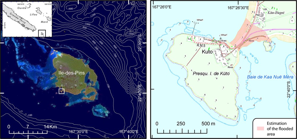
Location and neighborhood of the peninsula of Kuto, and evaluated limits of the “around 1940” flooding (map from DITTT, numbers with dots describe the elevation).
Localisation et voisinage de la presqu’île de Kuto, et évaluation des limites de l’inondation d’ « autour de1940 » (fond de carte DITTT, valeurs chiffrées correspondant à des points cotés).
The link between these two events is uncertain as the witnesses, especially the one “around 1940”, could not provide precise dates.
No link could be made between these time periods and any earthquake, but the phenomenon seems to be linked to a local quake and/or landslide.
3.4.3 December 1950 – February 1951, unspecified date (testimonies, newspaper archives and Parish archives)
In Hienghène, on a fair weathered and windless day, three witnesses report having seen a high and fast swelling of 80 cm high carrying a man in his canoe up the La Hienghène River from Koumaniny until Ganem (1.3 km). The riverbanks were almost all flooded, leaving numerous fish stranded ashore.
The tidal wave also affected Poindimié (causing the flooding of the Wagap tribe by 2.5 m of water, three witnesses), Ponérihouen (important progradation by sediment and coral deposits near the Mou tribe, two witnesses), Canala (one witness), Île-des-Pins (one witness). Fig. 6 illustrates the location of the witnesses during the observations, and summarizes the observations in each area.
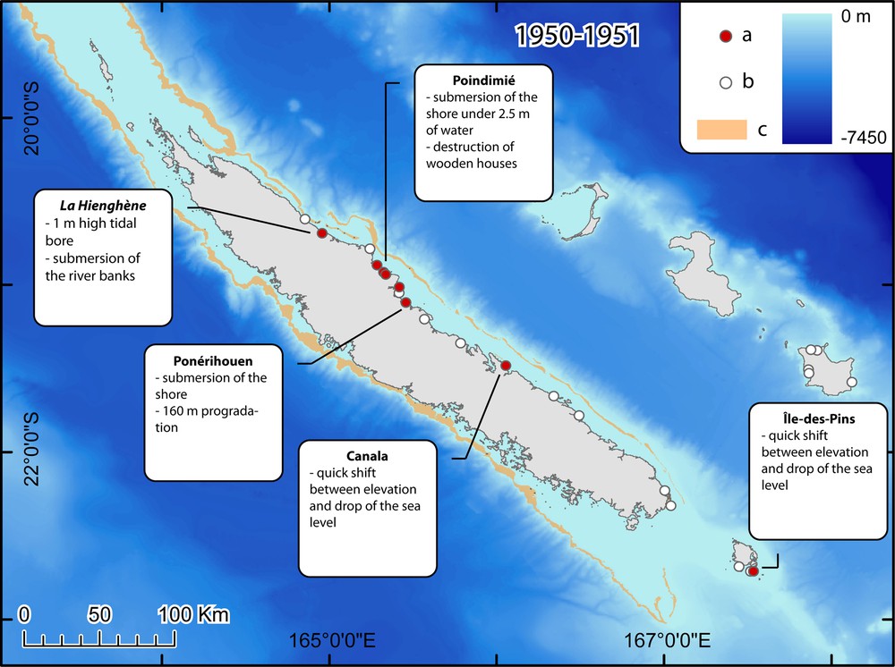
Hydrological anomalies observed in 1950–1951 (a: record, b: deny, c: coral reef barrier, DITTT data).
Anomalies hydrologiques observées en 1950–1951 (a : affirmation, b : infirmation, c : barrière de corail, données DITTT).
A previous record (Louat and Baldassari, 1989), based on local testimonies, mentions a tsunami in 1951 on Ouvéa that caused two deaths. The precise date of its arrival is not recorded. During our investigation, six witnesses described the aforementioned phenomenon. The two deaths mentioned by Louat and Baldassari (Louat and Baldassari, 1989) were invalidated by the local communities and by the Public Records Office as no death was mourned during this event. In reality, two people were missing after the flood and considered dead. They were isolated on an island during the event; however they arrived alive on Ouvéa several days later. This could explain the two deaths recorded by Louat and Baldassari.
Newspaper archives make a direct link between the flooding on Ouvéa and the 26–27 February 1951 typhoon which affected New Caledonia (La France Australe dated 28 February 1951). In a letter dated 29 March 1951 that was addressed to the archbishop, the missionaries from Wagap (Poindimié) noted the passing of a tidal wave without specifying the meteorological context in which it occurred or its date of occurrence. Are the observations recorded in Poindimié related to a cyclone or to an earthquake? On the other hand, most testimonies indicate these events occurred during a fair weathered day.
The observations (except those recorded on Ouvéa) could be linked to the 2–3 December 1950 series of earthquakes which occurred in Port Villa, Vanuatu, and generated a runup in Erakor (O’Reilly 1956 in (Louat and Baldassari, 1989)). The quake was felt in Thio (east coast) and Bourail (west coast) on the 3 December around 7:00 am during 1 min 20 sec (La France Australe dated 5 December 1950). Newspapers do not mention any tidal wave or damage during, or following, this quake.
3.4.4 1952–1959, unspecified date (testimonies)
Numerous witnesses mention important tidal waves occurring during fair weather. The(se) event(s) affected Hienghène (1 witness, Alfred K., 63 y.o.: “between 1952 and 1955”), Touho (2 witnesses, Raymond E.: “around 1955” and Jean P., 66: “around 1958”), Poindimié (1 witness, Jean D., 60: “around 1959”) and Ouvéa (1 witness, Elisabeth W., 77: “around 1957”).
The lack of precision in these testimonies did not allow one to link them to a specific earthquake or other tsunamigenic event. As only one witness indicated a time period that included the year 1952, the 1952 Kamchatka tsunami event could not reasonably be identified as the one having an effect on all these locations. However the possibility that the observations in Hienghène are linked to the 1952 Kamchatka tsunami event cannot be excluded either.
3.4.5 Beginning of the 1980s (possibly in 1983), unspecified date (testimonies)
Between 7 and 8 am, a series of strong waves (seven waves, the first being the strongest) swept the beach of the Larégnère Island, located in the Nouméa lagoon. It occurred during the weekend, probably on a Sunday, during very calm weather. The first wave reached the summit of the island and swept away beach gear and attire.
At the Arboré reef, a witness also reports that his Zodiac boat was suddenly overturned by a tidal wave in this range of years. The link between these two events is uncertain as the witnesses could not provide precise dates.
The origin of such an event could be explained by a landslide along the barrier reef since the outer slope of the barrier reef west of Grande-Terre is very steep. Indeed, numerous zones of past landslides have been found during multibeam bathymetric surveys along the western margin of the New Caledonia ridge (Pelletier et al., 2004). Volcanic sources can be considered as well, especially submarine eruptions (Everingham, 1987).
3.4.6 13 March 1997 (testimonies and photographs)
Two witnesses (Muriel Agnel, teacher, and Alan A.) report a flood on Maré on this day. Around 9–10 am on this fair weathered morning, three waves of 3–4 meters high (crest to trough) arrived in Wabao Bay (Fig. 7A). The third one, being the strongest, flooded the shore reaching a 4 m. runup (50 m. inland). The road and the houses which were left opened were covered by a 30 cm layer of sand (in yellow on Fig. 7B). Cars were stuck in the sand. M. Agnel took pictures of the beach and the road the day after the event (Fig. 7C and 7D). Most of the sand had been removed from the road already.
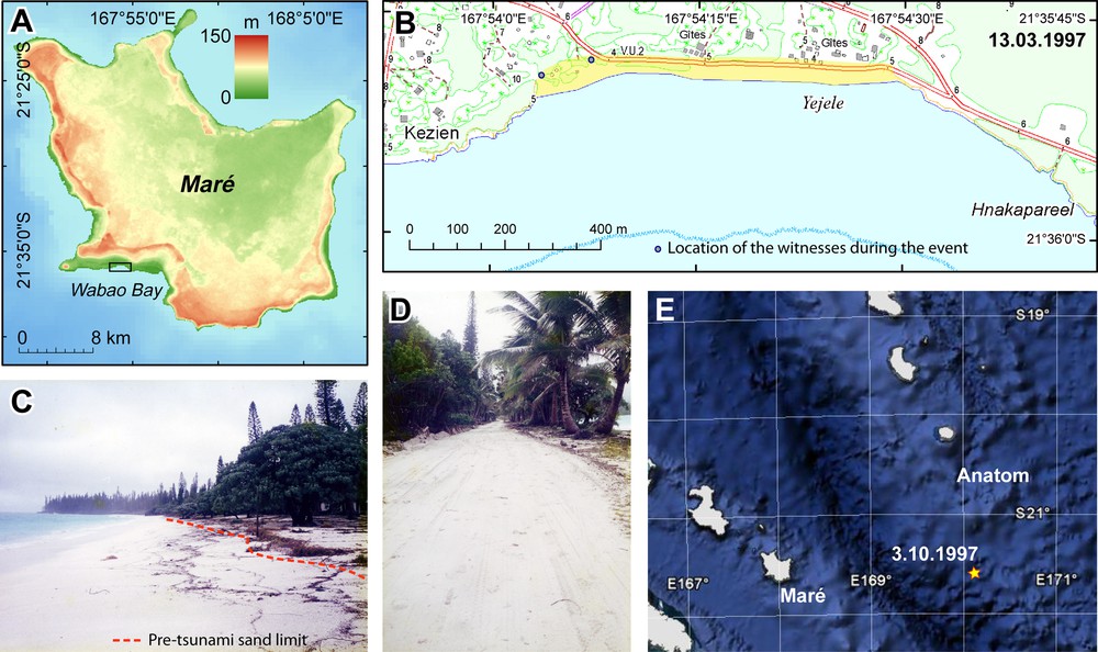
Events of 1997 (photographs by M. Agnel, AB: DITTT data and E: Google Earth background).
Événements de 1997 (photographie M. Agnel, AB : données DITTT and E : fond Google Earth).
On 3 October 1997, B. and M.-L. Gagosz report having seen an underwater volcanic eruption on their trip from Fiji to New Caledonia (Fig. 7D). They report seeing a water column (with a diameter of 20 m.) 900 m. away ejecting out of the sea 100 m high. This phenomenon is repeated six times at an interval of 20 min. They could not see or feel any wave (Les Nouvelles Calédoniennes, dated 4 October 1997).
The flood of 13 March 1997 could be linked to the submarine eruptions witnessed in October along the Vanuatu Islands axis. No significant earthquake was reported on this day.
4 Discussion
The collection of testimonies carried out in 2008 in New Caledonia highlights the unexpected impact of tsunamis, including transoceanic tsunamis, on this territory. Many of these impacts were unknown and unexpected by the scientific community. This collection of unreleased records completes the existing catalogs with the most recent events.
These results have to be considered carefully since the collection of testimonies involves many limitations: the lack of time given for the mission did not allow the investigators to encounter all possible witnesses. Concerning the records themselves, the notion of time and duration are very subjective, especially in rural and traditional coastal communities (lack of time reference points). Consequently, a number of testimonies lack precise dates and sources. Even though the interviewed communities are all situated along the shore, not everyone has the same knowledge of the sea, and consequently could not necessarily notice anomalies, and/or provide scientists with precisely quantified observations. As in most field surveys carried out a long time after an event, another limit is the possibility of witnesses mixing different events (Okal et al., 2002). All of these uncertainties result in an important heterogeneity in the quality of the recorded testimonies. Fig. 8 illustrates these results as well as their uncertainties, providing estimated runups for several events. These runups were measured with the help of the witnesses who could, in most cases, show us the limit of the inundation, handheld GPS units for XY location, and then 1/25000 maps from Direction des infrastructures, de la topographie et des transports terrestres (DITTT) for elevation.
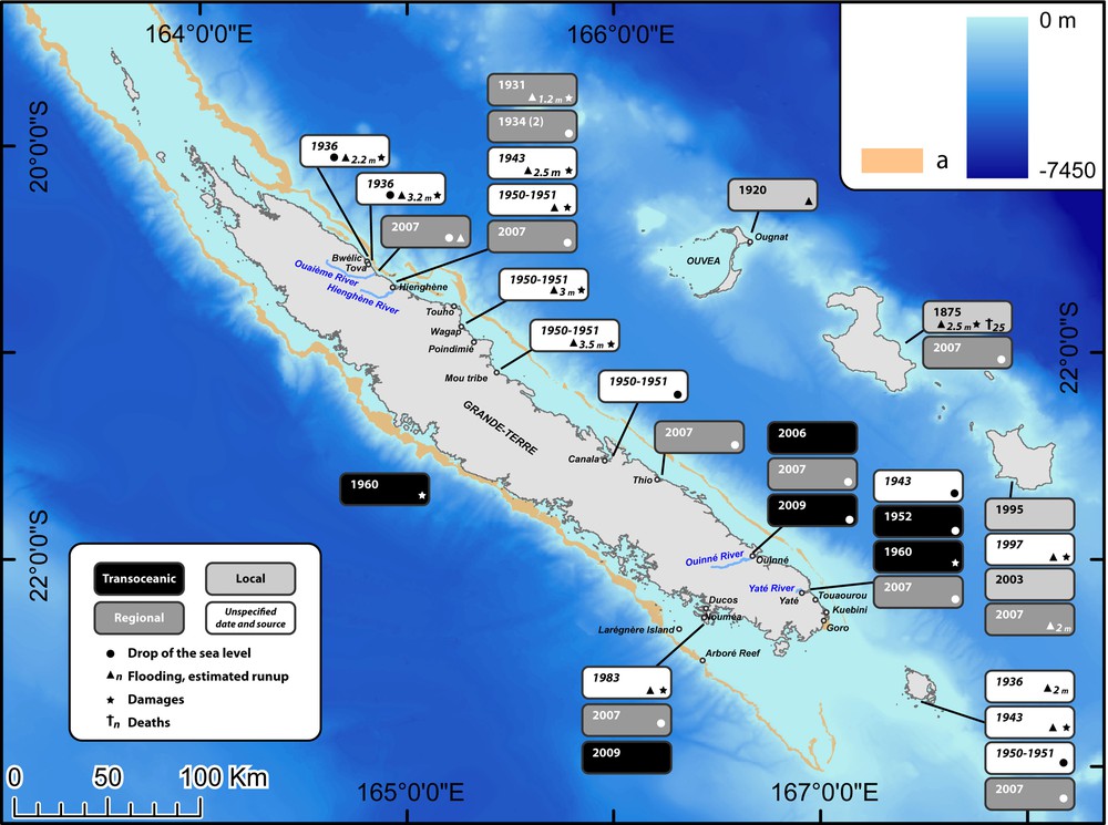
Areas impacted by tsunamis from 1875 to 2009 (a: coral reef barrier, background DITTT).
Régions ayant subi l’impact de tsunamis entre 1875 to 2009 (a : barrière de corail, fond de carte DITTT).
The 1952–1959 testimonies were neither represented, nor considered in the 18 tsunami events represented on Fig. 8 because of their uncertain links and lack of chronological precision.
For the oldest events (notably the one occurring at Lifou in 1875), the testimonies were passed down orally from generation to generation and thus the testimonies are subject to adaptations and exaggerations each time the story is told. The Melanesian oral tradition leaves no written trace, and therefore does not leave any unalterable record of past observations. On the other hand, the missionaries at the time left written records and accounts of unusual events, and landmarks such as ruins of buildings destroyed by the 1875 tsunami are still present on the field, providing scientists with an indication of the tsunami runup.
Lastly, as of the date of its appearance in the territory in 1889, the written press has provided daily papers that report witness testimonies. However, the objectivity and the precision of these records are difficult to estimate.
5 Conclusion
The information collected during the field investigation and in the various aforementioned archives reveals New Caledonia's real exposure to tsunamis of local, regional, as well as transoceanic origins. This exposure was not previously assessed by the scientific community and the authorities. The risk of a tsunami hazard appears sizable and constant, with delays between an earthquake and the arrival of tidal waves on the coast occurring in the range of 20 min for local phenomena to around 15 h for those of transoceanic origin. The Loyalty Islands appear to be the most exposed. However, the east coast of Grande-Terre is also exposed, especially the northernmost region, where tsunamis travelling from Solomon or North Vanuatu arcs have been recorded, and the southernmost region, where transoceanic tsunami have been noticed (Ouinné-Yaté-Goro region), likely due to the abnormal depth of the barrier reef.
The New Caledonian population is mostly concentrated on the shore and is therefore exposed to the hazard. The elders in the community have a good knowledge of the dangers of the sea, and therefore, in the past, had a tendency to inhabit areas further away from those hazardous areas. At the present, younger generations, being less experienced and often attracted to the conveniences that the shore offers, have a tendency to inhabit areas closer to the sea, and thus render themselves more vulnerable to tsunami hazards. These young populations, as most of them have not experienced any natural disaster, often adopt a fatalistic outlook with respect to such phenomena and possess a dangerous curiosity. Attesting to this curiosity is the fact that in April 2007 a large number of curious people went to the river bridges during the tsunami alert in order to watch the tsunami arrive. Luckily, this particular tsunami was of a small amplitude and allowed the curious people the opportunity to witness the variations of the sea level and accurately report this event without any loss of human life. Awareness programs need to focus on these younger populations.
A siren alert system is currently in the process of being implemented in New Caledonia by the Civil Security, using information received from the Pacific Tsunami Warning Center. However, the delays between the earthquake and the arrival of the tsunami waves are often quite small, highlighting the necessity to undertake important awareness campaigns to inform the exposed communities. People must be informed of the visible signs that precede the arrival of a tsunami on the coast: feeling an earthquake, and/or seeing an abnormal ebb/withdrawal of the sea, and/or animals fleeing in search of higher ground, etc. Armed with this information and a proper evacuation plan, inhabitants could take the appropriate action when faced with a locally triggered tsunami, or in the case of an alert system failure.
Such an alert system must absolutely include the installation of tide gauges and of a tsunameter between Vanuatu and the Loyalty Island.
Acknowledgement
The authors would like to thank:
The French Secretary of State for Overseas Affairs, and the UNESCO French Commission for having financed the field investigation carried out in 2008.
The High Commissariat of the Republic of New Caledonia and the Civil Security of New Caledonia for their logistical support, and more particularly Colonel Frédéric Marchi-Leccia, Richard Poido and Marie-Joelle Vendegou for their personal involvement in helping the mission.
The “Direction des Infrastructures, de la Topographie et des Transports Terrestres” (DITTT) who provided the authors with maps and numerical data for their field research.
The SHOM, MOP/BHNC, and specifically D. Créach, who provided the authors with the Nouméa tide gauge records for the 2007 tsunami.
The numerous witnesses who participated in this investigation, without whom the collection of this precious information would not have been possible.
Also, finally, Miss Christa Teplicky who kindly corrected the English version of this article.