

1 Introduction
The internal zones of the Hercynian belt of Brittany (western France) are marked by crustal stacking recorded from Late Devonian times (Bosse et al., 2002) and followed by regional extension during Late Carboniferous times (Burg et al., 1994; Cagnard et al., 2004; Gapais et al., 1993). The extension is limited to the north by the southern branch of the South Armorican Shear Zone (SASZ), a major dextral wrench zone (Jégouzo, 1980) (Fig. 1a).
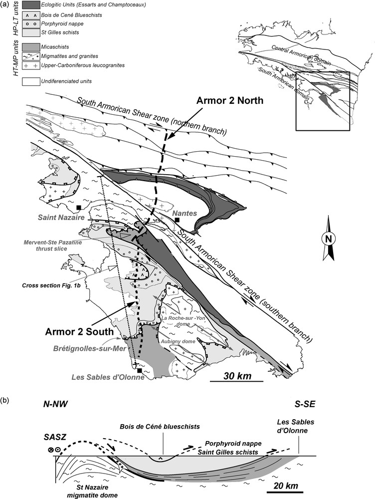
a: location of the ARMOR 2 North and ARMOR 2 South seismic profiles on a simplified geological map; b: sketch cross-section (located on (a), modified after [Cagnard et al., 2004]).
a : localisation des profils sismiques ARMOR 2 Nord et ARMOR 2 Sud sur une carte géologique simplifiée ; b : coupe géologique schématique subméridienne (localisée en (a), modifiée d’après [Cagnard et al., 2004]).
A first seismic reflection profile, about 70 km long, striking about north-south across the SASZ, was acquired in 2000 and published in 2003 (“ARMOR 2 North” profile, [Bitri et al., 2003]). In 2002, the profile was extended to the south by a new line (“ARMOR 2 South” profile). This article presents results and structural interpretation of this second profile (Fig. 1a).
2 Geological and structural setting
Three main groups of units are exposed in the South Armorican domain (Fig. 1) that, from top to base, consist in:
- • blueschists (Bois de Céné and Ile de Groix) (Bosse et al., 2002);
- • metavolcanic and metasedimentary rocks, so-called “Porphyroid nappe” (Colchen and Poncet, 1987; Vauchez et al., 1987), that also record a HP-LT metamorphic history (Le Hébel et al., 2002);
- • and a metasedimentary pile affected by Barrovian metamorphism (Ters, 1972; Goujou, 1992; Triboulet and Audren, 1988) known as the Sables d’Olonne metamorphic series (Cagnard et al., 2004).
The two upper units recorded burial to HP-LT metamorphic conditions and later exhumation from 370 to 350 Ma (Bosse et al., 2002; Le Hébel et al., 2002). At Brétignoles-sur-Mer (Fig. 1), the porphyroid nappe is thrust on top of Tournaisian low-grade metasediments of the Sables d’Olonne series (Colchen and Poncet, 1987; Iglesias and Brun, 1976). In the Sables d’Olonne series, Barrovian metamorphism increases in grade downward up to the development of migmatites with peak conditions around 750 °C and 800–1000 MPa (Goujou, 1992; Jones and Brown, 1990). Geochronological data indicate a rapid cooling of migmatites around 310–300 Ma (Brown and Dallmeyer, 1996; Gapais et al., 1993; Goujou, 1992) related to exhumation during regional-scale extension (Cagnard et al., 2004; Gapais et al., 1993) that brought into contact HT metamorphic domes with the actual supracrustal domains, made of previously exhumed HP-LT metamorphic units (Fig. 1b).
3 Seismic profile
3.1 Acquisition and data processing
The approximately north-south striking profile is about 72 km long, extending from Le Pont Béranger, south of Nantes, to La Brochetière, east of l’Ile d’Olonne (Fig. 1a). Data were acquired and processed by the Compagnie générale de géophysique in September-October 2002.
The source consisted of five vibrators AMG MERTZ 22 operating simultaneously, spaced at 12.5 m, with a 16 sec sweep. One vibrated point comprised the sum of nine linear sweeps with a 10–40 Hz frequency. Reflected waves were recorded by 244 traces with 50 m spacing and 24 geophones per trace – i.e. total length of 12,150 m. Shots were operated from the middle of the geophone line. Shot points with 200 m spacing along the profile led a theoretical coverage of 30. The seismic signal was recorded on 14 sec with a sampling step of 4 ms.
Data processing comprised in particular statistical corrections, velocity analyses, dip corrections, summation, filtering and time migration using wave equations.
3.2 Profile description
Fig. 2a shows the “ARMOR 2 South” profile (from 0 to about 2700 CDP) and its northward prolongation (from about 2700 to 3200 CDP) along the previously acquired “ARMOR 2 North” profile (Bitri et al., 2003). The section is of high quality and reveals a strong reflectivity throughout almost the entire crust (Fig. 2a).
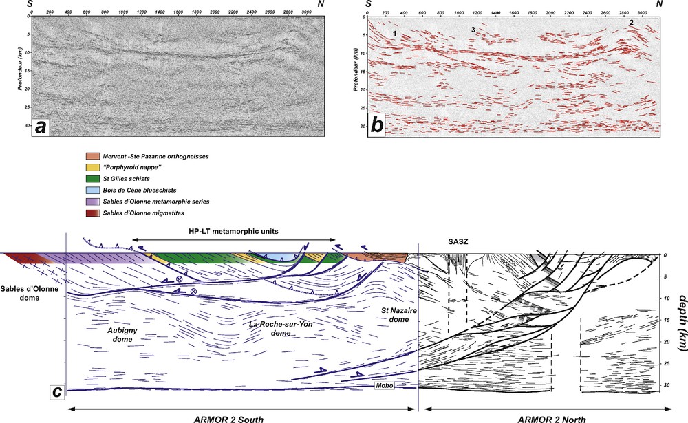
a: data from the ARMOR 2 South profile; b: extraction of main reflections (zones 1, 2 and 3 are discussed in text); c: interpretation of the ARMOR 2 South profile and correlation with the ARMOR 2 North profile (Bitri et al., 2003).
a : données du profil ARMOR 2 Sud ; b : extraction des principales réflexions (les zones 1, 2 et 3 sont discutées dans le texte) ; c : interprétation du profil ARMOR 2 Sud et corrélation avec le Profil ARMOR 2 Nord (Bitri et al., 2003).
The lower crust is strongly reflective all along the profile and appears to thicken from about 2–3 km to the north to about 5–7 km to the south. The Moho depth is rather constant, around 31–32 km.
The upper crust shows several high to very high reflectivity zones. The most striking is a sub-horizontal band of very high reflectivity, located around 10 km depth, with a length of about 40 km and a 1–2 km thickness. To the north, this band merges in a large antiformal structure imaged on both ARMOR 2 North (Bitri et al., 2003) and South profiles. Below this zone, most reflections are shallowly dipping and are organised in several more or less continuous bands.
4 Interpretation, discussion
4.1 Correlations with surface geology
Some groups of reflections may be correlated with surface data. In the southern part, North-dipping foliations observed in the Sables d’Olonne metamorphic pile (average dip of about 30°) (Cagnard et al., 2004; Goujou, 1992; Iglesias and Brun, 1976) can be extended downward, with a decrease in dip down to a sub-horizontal attitude between 5 and 15 km. Above, the base of the “Porphyroid nappe” can also be extended downward parallel to north-dipping reflections. This contact is connected to a zone of sub-horizontal reflections at about 5 km depth (zone 1, Fig. 2b).
To the north of the profile, an antiformal structure is located below the orthogneissic unit of Mervent-Ste Pazanne, interpreted as a thrust slice rooted in the southern border of the Essarts eclogitic unit, along a southernmost branch of the SASZ (Godard, 2001) (Fig. 1a). This particular zone remains however very poorly constrained by field and seismic data (zone 2, Fig. 2b). We infer that the orthogneissic thrust unit results from late transpression along the southernmost branch of the SASZ. The antiform located below the orthogneissic unit is attributed to the St Nazaire migmatitic dome that crops out just north of the profile termination and is also imaged on the “ARMOR 2 North” profile (Figs. 1 and 2).
In the central part of the profile, where HP-LT metamorphic units crop out, correlations are more difficult because of rather weak reflectivity. The interpretation we propose takes into account:
- • the surface geology;
- • the fact that all major contacts observed are of thrust type;
- • and the fact that normal brittle faults coeval with the Late Carboniferous extension may disturb the geometry of preexisting structures.
Consequently, we interpret sharp interruptions of high reflectivity bands (e.g. zone 3, Fig. 2b) as a consequence of brittle normal faulting (Fig. 2c).
4.2 Significance of the high reflectivity zone at 10–12 km depth
The sub-horizontal high reflectivity band located at 10–12 km depth has two major characteristics: it can be followed on long distance and it does not appear disturbed by overlying or underlying reflections (Fig. 2b). These features show that this seismic structure cannot be attributed to a particular lithology and may actually be interpreted as a relatively late tectonic structure.
To the north, the band appears to merge with the St Nazaire migmatitic dome (Figs. 1 and 2) whose overall geometry is comparable to the Golfe du Morbihan extensional core complex, located more to the west and exhumed during Late Carboniferous (Gapais et al., 1993). To the south, the St Nazaire dome is bounded by a normal shear zone overlain by HP-LT metamorphic units (Figs. 1 and 2c).
To the south, the high reflectivity band is connected with a domain of north-dipping reflections correlated with the Sables d’Olonne metamorphic dome, cored by migmatites and orthogneisses (Figs. 1 and 2c) (Cagnard et al., 2004). At regional-scale, syn-metamorphic stretching lineations strike east-west to WNW-ESE and are associated with top-to-the-west relative motion (Brun and Burg, 1982; Cagnard et al., 2004; Goujou, 1992; Vauchez et al., 1987), as a result of intense pervasive thinning of the metamorphic pile (of the order of 80%) (Cagnard et al., 2004). The age of extension is well documented, around 310–300 Ma (Goujou, 1992), coeval with extensional structures developed farther northwest (Gapais et al., 1993).
Other metamorphic and granitic domes (La Roche-sur-Yon, Aubigny, Fig. 1a), which also exhumed during Late Carboniferous (Goujou, 1992), occur in the southern part of the region. These domes trend about NW-SE and are mantled by lower-grade metamorphic units. The western domes boundary strikes about north-south and dips to the west and corresponds to a normal shear zone (Fig. 1a) (Cagnard et al., 2004). We interpret the high reflectivity zone at 10–12 km depth as the westward prolongation of this extensional shear zone. The wavy reflections below the zone likely correspond to the westward continuation of the Aubigny and La Roche-sur-Yon domes (Fig. 2c). In summary, this seismic line portrays at crustal-scale the structure resulting from major extension and thinning that affected the South Armorican Domain during the Late Carboniferous.
5 Conclusions
The “ARMOR 2 South” profile provided a seismic image of excellent quality, with a high reflectivity nearly throughout the entire crust, well correlated with the previously acquired “ARMOR 2 North” profile. Surface geology constrains the interpretation of the upper part of the profile in terms of thrust tectonics reworked by normal faults and low-angle shear zones of Late Carboniferous age.
A remarkable structure imaged on the profile is a very high reflectivity zone located at about 10–12 km depth. This flat-lying zone extends for more than 40 km and merges, to the north, in the St Nazaire migmatitic dome and, to the south, in the zone of intense crustal thinning that affects the Sables d’Olonne metamorphic series. We interpret this zone as a major zone of extensional shearing and crustal thinning developed during Late Carboniferous extension. Below this extensional shear zone, the wavy reflection pattern of the lower crust can be correlated with the St Nazaire, La Roche-sur-Yon and Aubigny domes. The Late Carboniferous extensional structures are superposed onto a stack of HP-LT metamorphic units, thrust and then exhumed in Early Carboniferous.
Acknowledgments
The authors thank Patrick Ledru and Philippe Matte (Director and President of the scientific comity of the Géofrance 3D Program (BRGM et CNRS-INSU), respectively) for their support in the development of the ARMOR 2 Project. We thank two anonymous reviewers for constructive remarks and suggestions of improvement.