

1 Introduction
The Atlantic margin of northern Morocco is bounded by the Rif mountain belt, the westernmost termination of the Mediterranean-Alpine chain (Fig. 1). This is a key area for understanding the recent evolution of deformation caused by the relative movements of Africa and Eurasia. The current convergence of these plates in a roughly NW–SE direction is expressed by a diffuse deformation across a large area (about 200 km in north-south width) encompassing the entire of the Rif-Betic arc, the Alboran Sea and the Gulf of Cadiz (Jiménez-Munt et al., 2001; Sartori et al., 1994; Stich et al., 2006; Tortella et al., 1997). This latter region is characterized by a large accretionary wedge formed by the westward motion of the Rif-Betic arc since the Miocene (Gutscher et al., 2009b; Gutscher et al., 2006; Gutscher et al., 2002; Iribarren et al., 2007). There is a broad consensus among most workers that the Rif-Betic arc has been transported westwards over distances of several hundred km (Platt et al., 2003 and references therein], with respect to the African plate. There is disagreement, however, on the driving force behind this motion and the current kinematics of the region. Three different types of models are invoked to explain this westward motion: delamination type models driven by detachment of heavy overthickened continental lithosphere (Calvert et al., 2000; Chalouan et al., 2008; Plaziat et al., 2008); westward extrusion due to the NW–SE Africa-Eurasia convergence (Fernandez ibanez et al., 2008; Serrano et al., 2003); and finally eastward dipping subduction of oceanic lithosphere, associated with westward rollback of the subducting slab (Gutscher et al., 2002; Lonergan and White, 1997). In all cases, the existence of major dextral strike-slip faults in the Betics (Platt et al., 2003) and sinistral strike slip faults in the Rif are necessary to accommodate this westward migration of the Rif-Betic arc from Tortonian to Quaternary times (Ait Brahim, 2003; Mouhssine et al., 2003).
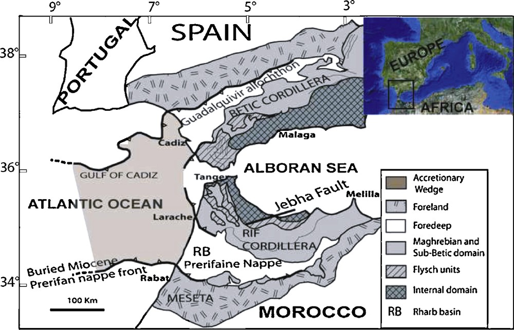
Geological setting of the Gibraltar arc with major structural domains, modified from Flinch, 1993.
Contexte géologique de l’arc de Gibraltar avec les domaines structuraux majeurs, modifié d’après Flinch, 1993.
In addition to the two major plates, Nubia (Africa) and Iberia (Eurasia), the Iberia–Morocco region is marked by a small intermediate block, which can be considered the Rif-Betic-Alboran block (Gutscher et al., 2009b; Gutscher, 2004). The presence of this intermediate block is clearly delimited by recent seismicity (Gutscher et al., 2009b; Stich et al., 2005). GPS observations indicate that stations in the north-central Rif are moving west to WSW with respect to Eurasia and southwest with respect to Nubia (Fernandez ibanez et al., 2008; Tahayt et al., 2008). Thus, the current kinematics indicate that movement between the north-central Rif and the Moroccan Meseta is primarily sinistral, possibly with a component of compression. This relative motion does not appear to be localized on a single fault, but is likely accommodated by a series of NE–SW trending faults, which on the Alboran Sea coast have expressions as the Jebha and Nekor faults (Chalouan et al., 2001; Chalouan et al., 2006; Frizon De Lamotte, 1985; Morel, 1989; Serrano et al., 2003). These faults do not have clear prolongations through the Rif mountain belt all the way to the Atlantic and such a possible connection is the subject of ongoing research.
It has also been suggested that the Jebha fault exhibited two phases, during Miocene as sinistral fault, that it may have been reactivated as a dextral fault during Pliocene and Quaternary.(Benmakhlouf et al., 2005; Chalouan et al., 2006).
Offshore in the Gulf of Cadiz the accretionary wedge has been imaged by multi-channel seismic data as well as multibeam bathymetric data (Gutscher et al., 2009a; Gutscher et al., 2009b; Gutscher et al., 2006; Pinheiro et al., 2003). The morphological data reveal the presence of many gravitational instabilities associated with gravity spreading lobes in the eastern upper wedge and blind thrust suggesting active tectonic shortening in the western lower wedge (Gutscher et al., 2009a). The southern border of the accretionary wedge is bounded by a sharp east-west striking lineament interpreted to be a transpressional lateral ramp (Gutscher et al., 2009b). The orientation of this east-west limit suggests a continuity with the east-west trending Lalla Zahra hills but the lack of data across the continental shelf does not allow reliable structural correlations to be established between land and sea. Bridging this data gap was one of the primary objectives of the seismic reflection survey NOMADS whose results are the subject of this article.
Other objectives were to establish the seismic stratigraphy for the western offshore termination of the southwestern Rif front and to seek evidence for recent Quaternary deformation which may affect the zone and finally to search for east-west oriented structures within the shallow marine Rharb basin which may represent the offshore continuation of the Lalla Zahra deformed zone.
2 Geological and morphological setting
From Tangiers to Rabat, the Moroccan Atlantic margin has been structured by the Rif mountain belt and its foreland. The Rif belt is characterized by a pronounced southward to west-southwestward vergence of thrust nappes. The sequence from north to south includes the Flysch Magrhébides (Numidian) resting on the External Zones of the cordillera that includes three distinct structural zones characterized by a complex stacking of nappes described on-land: the Intrarif, the Mésorif and the Prérif (Fig. 1). This last domain is the most widespread along the Atlantic coast and represents a vast flexural basin, located between latitudes of Larache and Rabat. This basin underwent strong subsidence in the Tortonian in response to the stacking of the pre-Rif nappes whose blind front is currently located at the latitude of the city of Kenitra. It is divided into a foredeep basin, the Rharb foredeep basin parallel to the southern edge of the Rif and containing more than 5000 m of post-Paleozoic deposits and a shallower foreland basin, the Mamora (Cirac, 1983; Flinch, 1993; Zouhri et al., 2001). The latter basin represents the hinge with the domain of the stable western Meseta located to the south-west of Rabat where Paleozoic basement outcrops on-land. The coastal fringe of the pre-Rif flexural basin presents only minor post-nappe deformation with the exception of the folded Lalla Zahra hills (Fig. 2). These 100 m high hills are oriented east-west and located near the northern limit of the Rharb Basin. They represent a large scale anticlinal fold, with an east-west oriented fold-axis with local faulting that affects the Lower Pliocene deposits (Gutscher et al., 2006; Morel, 1989). This structure separates the Moulay Bouselham sub-basin from the main part of the Rharb basin. The sub-basin is occupied by a large Holocene lagoon located at the mouth of Drader river. Recently, a subhorizontal layer of lagoonal deposits dated at 2000 ± 500 yr BP, was discovered at an elevation of +30 m on the northern border of the lagoon. This led to the hypothesis of “hyperactive tectonics” related either to strong uplift along a major fault in the continuity of the Drader river or alternatively to diapiric processes similar to mud volcanoes offshore (Benmohammadi et al., 2007). Further east, several reverse faults 110°N–160°E oriented affecting Villafranchian deposits are mentioned in the Arbaoua area (Chalouan et al., 2008).
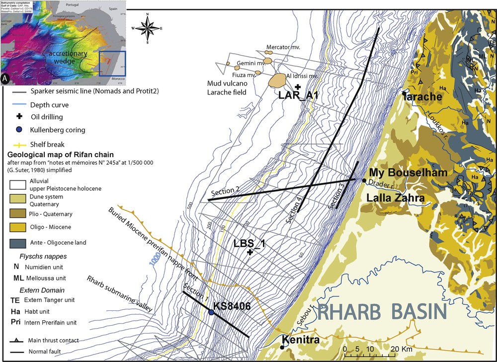
A. Multibeam bathymetric compilation of the Gulf of Cadiz from Gutscher et al., 2009b; the location of the figure B is indicated by the blue rectangle. B. Location of seismic lines with geological map and bathymetry of the continental shelf from Suter, 1980; Vanney, 1977, sections in black are shown in the paper.
A. Compilation des données de bathymétrie multifaisceau du Golfe de Cadiz d’après Gutscher et al., 2009b ; la localisation de la figure B est indiquée par le rectangle bleu. B. Localisation des profils sismiques avec carte géologique et bathymétrie du plateau continental, d’après Suter, 1980; Vanney, 1977 ; les sections sismiques noires sont présentées dans cet article.
At sea, the morphology of the Atlantic portion of the western-Rif platform reflects the structure of the belt. The general bathymetry is known from previous work (El Foughali, 1982; Vanney, 1977). Recently multibeam bathymetric surveys were conducted in the deeper offshore regions (200 m to 3000 m water depth) during the Delila cruise and DelSis cruise (Hansen et al., 2007). Two domains can be distinguished on either side of the Lalla Zahra lineament (Fig. 2).
The northern domain is characterized by a regular continental shelf of 30 to 25 km width, with a shelf break around 150 m and showing a high rugosity. Its deep offshore prolongation is the huge tectono-sedimentary complex, which thins to the west and occupies the central Gulf of Cadiz (Fig. 2A) This whole complex corresponds to the Gulf of Cadiz accretionary wedge (Hansen et al., 2007).
The southern domain corresponds to the offshore part of the Rharb basin and is characterized by a shelf of variable width, ranging from 35 to 20 km. It is thinned at the southern edge where it is connected at the shelf break to a major canyon called “the Rharb submarine valley”. The smoothness (low rugosity) of the shelf and swollen geometry of isobaths of the inner part 1 illustrate the volume of recent sedimentation driven by the input from the Sebou River, characterized by the highest volumetric flow and the largest sediment load of all Moroccan rivers (Jaaidi, 1993).
3 Data
The present study is based on the interpretation of a set of 34 high-resolution seismic lines (about 1600 km), acquired during the two surveys PROTIT2 (2003) and NOMADS (2007) (Figs. 2 and 6 grey lines). The surveys were carried out aboard the Moroccan vessel Al Manar and the French R/V Côtes de la Manche. The acquisition system was composed of a Sparker Source, a six-channel SIG streamer and a numerical DELPH2 acquisition system. The emission energy ranged from 250 to 1000 J, the shooting rate was 1.5 s and the vessel bottom speed was 5 knots. All digital data were stacked and filtered (100–700 Hz) using the Unix Seismic code and Seismic Processing workshop (parallel Geosciences Corporation). Seismic lines were interpreted using Kingdom Suite software (Seismic micro technology INC). Seismic units are displayed with two travel time in ms. The time-depth conversions described in the text are made assuming an average velocity of 1800 m/s given by velocity analyses associated to industrial seismic lines available across the surveyed area and provided by the Moroccan Office national des hydrocarbures et des mines (ONHYM).
Seismic sequence units were identified using criteria outlined by Mitchum and Vail, 1977. The chronostratigraphic interpretation of identified seismic units were constrained by some coring data from GEOMAR survey (Jaaidi, 1993) and the industrial well logs LAR-A1 and LBS-1.
4 Seismic stratigraphy
Three main seismic units, Q1, Q2 and Q3, observed on a regional scale, can be distinguished on the high-resolution seismic sections. Their internal geometry and the unconformities that separate them define a succession of stacked prograding wedges. The section 1 (see Fig. 3), located off the mouth of the Sebou River presents weak deformations and illustrates the architecture of these units.
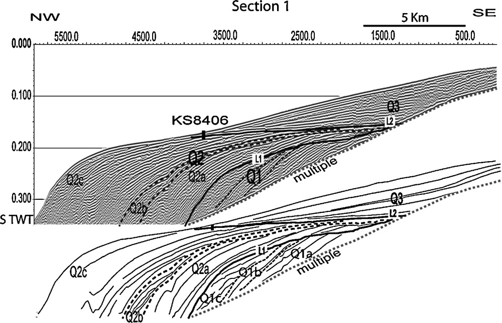
Seismic section 1 and interpretation, located perpendicular to the shoreline, off the Sebou River mouth. Three main units are identified Q1, Q2 and Q3 units with local sub-units and major unconformities L1 and L2. The KS8406 core from GEOMAR survey (Jaaidi, 1993) is located on the section. Note the increase of clinoforms deep within Q1 unit, the progradational/aggradational pattern of the Q2 unit and the aggradational to progradational deposits of the Q3 unit that corresponds to the prodelta of the Sebou River.
Section sismique 1 et son interprétation, située perpendiculairement à la côte, au droit de l’embouchure de la rivière de Sebou. Trois unités majeures sont identifiées Q1, Q2 et Q3 avec les discordances L1 et L2 et les sous-unités locales. Le carottage KS8406 de la campagne GEOMAR (Jaaidi, 1993) est positionné sur la section. Noter l’augmentation du pendage des clinoformes au sein de l’unité Q1, les couplets progradant/aggradant de l’unité Q2 et les dépôts aggradant à progradant de l’unité Q3 qui constitue le prodelta de la rivière Sebou.
The basal unit Q1, where only the summit is visible above of the first sea level multiple, displays oblique, continuous and steeply dipping reflections, with a high amplitude and high frequency reflection facies. The internal clinoform angles decrease towards the northwest. The upper boundary of Q1 is the major erosional unconformity L1, truncating underlying reflectors on toplaps. The local change of the internal clinoform geometries associated with enhanced unconformities allows us to identify three subunits Q1a, Q1b and Q1c. The subunit Q1b is marked by more dipping clinoforms than Q1a while Q1c shows an aggrading pattern of reflectors.
The Q2 unit displays sigmoid, continuous and very gently dipping reflections, with high amplitude and medium frequencies. It presents a progradational and aggradational pattern; its high thickness allows us to distingush three local subunits, Q2a, Q2b and Q2c. The Q2a subunit is characterized by low angle clinoforms and downlaping reflectors above the lower boundary L1. The Q2b subunit shows few continuous internal reflectors that show onlap terminations on the upper unconformity of Q2a and pinches out landward. The subunit Q2c presents numerous reflectors determining a succession of aggradational/progradational pairs affected by gravity deformation and incisions. The upper boundary of the subunit Q2 is the second major erosional unconformity (L2), correlated at a regional scale and covering the inner and the median shelf.
The Q3 unit also displays a prograding to aggrading pattern and has a maximum thickness off the mouth of the Sebou River. Its inner reflectors are continuous, with high amplitudes and low frequencies. It extends over the entire continental shelf fringing the continental Rharb basin and corresponds to the prodelta of Sebou River. Acoustic masking, covering seismic units Q3 and Q2, is identified close to the mouth of the Sebou River and considered to be induced by the presence of organic matter in sediments.
5 Chronostratigraphy
Chronostratigraphic attributions are primarily based on the two LAR-A1 and LBS-1 oil wells and the KS8406 core drilled in the study area (see Fig. 2 for location). Biostratigraphic analyses available from both wells were supplemented by a micropaleontological analysis of the cuttings from the LBS-1 well, conducted by the ERADATA company. The latter analysis establishes the limit of PL6 (Gelasian) to Pt1 (Calabrian to Upper Pleistocene) biozones at 1009 m depth at the LBS-1. On the other hand, the lower limit of the Pleistocene cannot be determined at the LAR-A1 well, which is due to lost circulation during drilling in its upper part. However, Pleistocene deposits can be recognized, in this well, down to a minimum depth of 126 m below sea level.
The depth of the L1 unconformity, calculated at 100 m at location of LAR-A1 and at 90 m at location of LBS-1, leads us to consider all units, identified at HR seismic data, as Pleistocene. The high thickness of the Pleistocene, identified at the LBS-1 drilling, located in a non-deformed area, allows us to propose a Middle to Upper Pleistocene age for Q2 and Q3 units located above the L1 unconformity.
The L2 surface expressed as an uncoformity at the bottom of the Sebou prodelta, however, has been dated by KS8406 Kullenberg coring to 15 ka (± 250 years BP) (Jaaidi, 1993). It corresponds to the erosional surface exposed during the Last Glacial Maximum (LGM) and the overlying prodelta deposits are consequently considered as postglacial highstand deposits.
6 Isopach map
The isopach map of the Q2 Pleistocene unit allows us to characterize the recent deformations of the western Rifan continental shelf. The seismic lines (section 1 to 4: Figs. 3, 4 and 6) parallel and orthogonal to the coastline provide complementary image of the internal structures. The spatial distribution of the Pleistocene Q2 seismic units reflects the tectonic behaviour of the shelf between the latitudes of Kenitra and Asilah cities, where three domains can be identified. In the southern part, from Kenitra to the offshore prolongation of Lalla Zahra hills, the corresponding Q2 deposits are weakly disturbed by tectonics. In the central zone, from Lalla Zahra hills to Larache, deformation is concentrated and involved the whole shelf. In the northern part, the Q2 unit is almost absent and Neogene nappes crop out at the seabed.
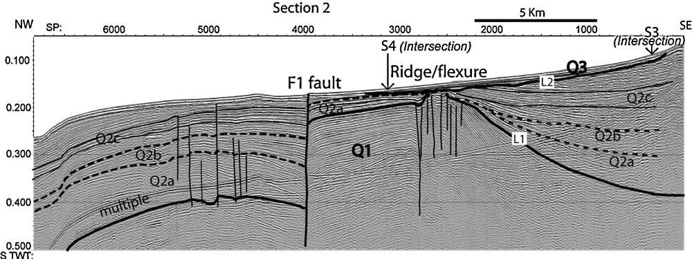
Seismic section 2. The fan geometry and the thickening of Q2 unit within the eastern depression confirm the syntectonic character of sedimentation. The F1 fault affects the sea bottom and shifts the L1 unconformity of 0.18 s TWT.
Section sismique 2. La géométrie en éventail et l’épaississement de l’unité Q2 au sein de la dépression à l’est attestent le caractère syntectonique de la sédimentation. La faille F1 affecte le fond marin et décale la discordance L1 de 0,18 s TD.
The southern domain corresponds to the currently subsident area of the Rharb foredeep basin. The platform is built along the blind front of the Prerifan nappes overlapping the flexural Meseta domain. The thickness of the Q2 unit remains below 0.2 s TWT through the inner and median shelfs. It becomes thicker southward and depicts a more subsiding area corresponding to the “Rharb submarine Valley” shown on bathymetric map (Fig. 2). The isopachs of Q3 unit are also indicated on the map; their spatial distribution confirms the subsident character of the area during the Holocene. This trend is also confirmed by the abrupt change of the Sebou channel orientation, near Guedadra village, from SE–NW to NE–SW along the present coastline. Further offshore, the Q2 thickness progressively increases seaward towards the outer shelf and northward close to the offshore extension of Lalla Zahra hills.
The central domain reveals significant variations in thickness across the entire shelf. The maximum thicknesses of Q2 are observed:
- (i) along a NW-SE trending corridor parallel to the boundary of the Neogene nappes (section 4B Fig. 4);
- (ii) across the inner platform, parallel to the coastline, with two distinct depocenters (section 3, Fig. 4 for the southern depocenter);
- (iii) to the South-West of Lalla Zahra where Q2 thickness reaches more than 0.45 S TWT (nearly 400 m).
Furthermore, section 4A (Fig. 4) illustrates two syncline folds affecting the Q1 unit. These depocenters are separated by a minor faulted ridge at the latitude of Moulay Bouselham city. All these depocenters are controlled by active faults or flexures suggesting the presence of reactivated inherited structural weaknesses.
The fan shaped geometries and the thickening of the sedimentary layers within faulted depocentres demonstrate syntectonic sedimentation (section 2, Fig. 5 and section 3, Fig. 4). Furthermore, several ridges observed on seismic profiles can be mapped. They correspond to anticlinal folds developed in weak material involving disharmonious deformation and locally induced by faults (section 3, Fig. 4). The fact that anticlines correspond to zones of reduced thickness is also confirmed by the syntectonic character of folding. Two of them cross the entire width of the shelf. A northern ridge, named Larache ridge, is oriented WNW-ESE in its seaward portion before curving to a NNE-SSW direction parallel to the flexure/ridge boarding the coastal depocenters of Larache – Moulay Bouselham area (Fig. 6). The map also shows the link between the El Arraiche mud volcanoes field, located offshore of the coastal city of Larache with a trend about N120°E, and the above ridge. The volcanoes are located above the ridge where fluid overpressure could be enhanced by local compression. These mud volcanoes underscore the degree of hydrological activity within the accretionary wedge caused by compression and dewatering of highly porous marine sediments. Geochemical analyses of the fluids obtained by sampling the mud volcano sediments indicate the likely presence of evaporites within the uppermost group. Fluids from some of the deeper mud volcanoes also bear the geochemical signature of clay mineral dehydration at temperatures near 150 °C, processes commonly observed in other accretionary wedges (Hansen et al., 2007; Van Rensbergen et al., 2005).
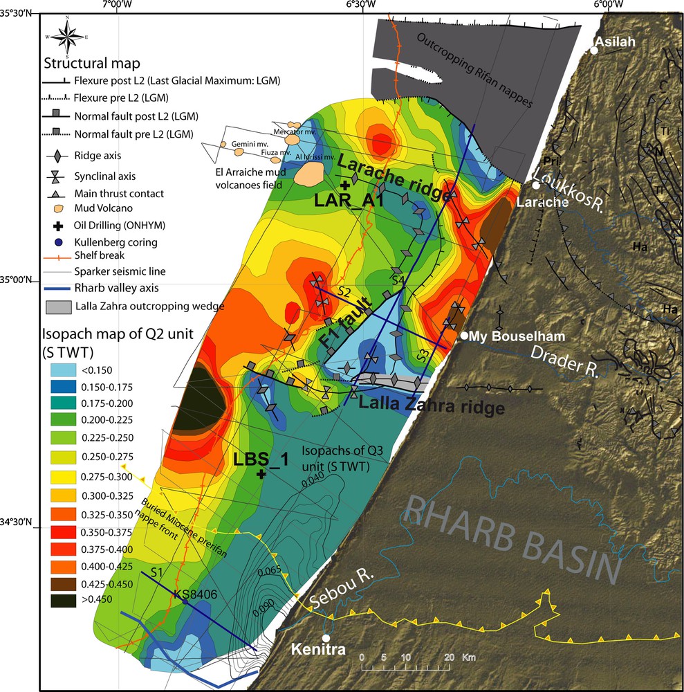
Structural map with isopach map of the Q2 seismic unit. Topography from SRTM3 (90 m). Three structural domains are identified: a northern domain, North of Larache city, marked by the outcropping of the Rifan nappes, a central domain, between Larache city and Lalla Zahra hills latitudes, strongly deformed with maximum thickness (> 0.35 s TWT), a southern domain with little or no deformation. The isopachs of Q3 unit are also shown. This unit corresponds to the prodelta of the Sebou River. Blue thick lines are seismic sections 1 to 4 shown in paper.
Carte structurale et carte isopaque de l’unité Q2 ; topographie extraite de SRTM3 (90 m). Trois domaines structuraux sont identifiés : un domaine septentrional, au nord de la latitude de la ville de Larache, marqué par l’affleurement des nappes rifaines ; un domaine central, entre les latitudes de la ville de Larache et les collines de Lalla Zahra, largement déformées avec des épaisseurs maximum (> 0,35 s STD) ; un domaine méridional peu déformé. Les isopaques de l’unité Q3 correspondant au prodelta de la rivière de Sebou sont aussi représentées. Les lignes bleues épaisses représentent les sections sismiques 1 à 4 présentées dans cet article.
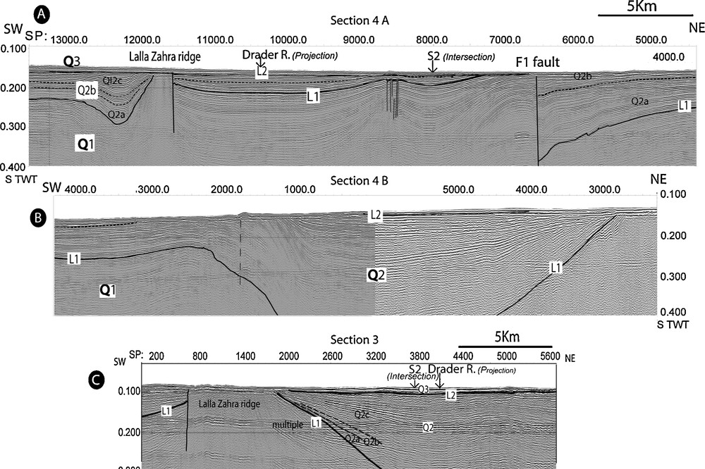
Top: seismic section 4 (divided on two parts A and B) parallel to the shoreline. The part A shows the Lalla Zahra ridge and the F1 fault with apparent offset of 0.25 s TWT. The Q3 unit is not affected by deformation and presents parallel internal reflectors. The part B shows asymmetric depocenter where the thickness of Q2 unit exceeds 0.25 s TWT; in this section also the thickening and fan geometry of Q2 unit document the syntectonic sedimentation, the northern side of the section is marked by the outcropping of the Rifan nappes with chaotic internal signal. C: seismic section 3 parallel to the section at 3 km from the shoreline. The Lalla Zahra ridge outcrops at the sea bed.
En haut : la section sismique 4 (divisée en deux parties A et B) parallèle à la côte. La partie A montre la Ride de Lalla Zahra et la faille F1 associée à un rejet apparent important de 0,25 s TD. L’unité Q3 n’est pas affectée par la déformation et présente des réflecteurs internes parallèles. La partie B montre un dépocentre asymétrique où l’épaisseur de l’unité Q2 dépasse 0,25 STD ; l’épaississement et la géométrie en éventail de l’unité Q2 démontrent aussi le caractère syntectonique de la sédimentation ; l’extrémité nord de la section est marquée par l’affleurement des nappes rifaines avec un signal interne chaotique. C. Section sismique 3 parallèle à la côte, avec ride de Lalla Zahra, affleurante sur le fond.
To the south, the Lalla Zahra ridge is oriented east-west, perfectly in the continuation of the Lalla Zahra hills. The width of this structure, of 1 to 2 km, is less than the northern one, but its structural expression, separating southern and central domains, appears important. The Lalla Zahra ridge, bounded by a sub-vertical fault alternately along its northern and southern flank, outcrops closer to the coastline and presents a chaotic to transparent seismic facies. This acoustic response may be caused by an argilokinetic deformation mechanism, with injection and internal deformation of a hydroplastic materials associated with the argillaceous Neogene cover or possibly the underlying Pre-rif nappes. Furthermore, the bending of the Q2 seismic reflector that onlaps the ridge on both sides provides evidence of vertical uplift during the deposit of the Q2 unit. Nevertheless, the apparent parallel pattern of Q3 seismic reflectors above the Lalla Zahra ridge (section 3, Fig. 4) suggests the absence of deformation during Holocene. This could also be explained by a low rate of deformation (< 0.1 mm/yr) undetectable by the metric seismic resolution.
Further west, the geometric expression of the ridge becomes a flexure. This latter structure is the prolongation of another ridge located close to the shelf-break. A major active fault named F1, which shows a large offset reaching locally about 150 m (section 2, Fig. 4), presents an oblique termination at the contact of the Lalla Zahra ridge. The southern termination of the flexure/ridge, shown in this map and in section 2 Fig. 4, presents also an oblique termination near the east-west trending Lalla Zahra zone and its offshore continuation at the northern limit of the Rharb submarine valley located at the southern border of the accretionary wedge. Furthermore, the analysis of seismic lines (grey lines Figs. 2 and 5) allow us to affirm that no mud volcanoes have been observed on the upper slope south of the Larache ridge.
The northern domain is marked by the outcropping of Neogene overthrust (section 4, Fig 6) related to the Mesorif and Prerif structural domains. These nappes, with a transparent to chaotic pattern, are identified on land on the right bank of the Loukkos River. They consist of pelitic and sandy beds (Mrayt group) bounded by a westward thrust (Tejera De Leon and Duee, 2003). In absence of additional seismic lines north-south to NE-SW trending structures could not be identified in this domain. The northern border of outcropping nappes is also located in the continuation of the Plio-Quaternary cover outcropping on the coast. The tilt of stacked erosional truncations identifiable within the Q2 unit bounding the southern flank of the nappes shows that the uplift of the Neogene nappes complex is synchronous with the Q2 unit deposit.
7 Deformation regime and inherited structures
The Q2 Isopach map demonstrates the existence of an active offshore southern Rif front (Lalla Zahra) during Pleistocene times. This deformation does not involve the reactivation of the inactive buried Miocene deformation front commonly known as the Prerifan nappes front. The ongoing deformation is limited to the segment located between Lalla Zahra ridge and the outcropping Neogene nappes at the north of Larache. The observed deformation shows a significant compression in the northern zone leading to an extrusion of the nappes. This uplift creates a synclinal fold along the front of the nappe, where the Quaternary deposits fed by the Loukkos River can be deposited. To the south, a folding style of deformation is also confirmed, however, vertical movements are smaller. The oblique terminations of faults along the Lalla Zahra ridge and its western continuation suggest that the structure is transpressive. Folds and faults, observed between Lalla Zahra ridge and outcropping nappes, define a general arched geometry whose concavity is open toward the west.
An onshore continuation of the structures observed offshore can be deduced from geological maps of the South Rifan coastal area (Morel, 1989) and complementary field observations. As shown on the map (Fig. 7), the northern border of the outcropping wedge has an apparent continuation along the main thrust front of the Flychs nappes (Numidian Unit) identified north of the Asilah city while the NW–SE southern front of the Rifan nappes seems to correspond to the continuity of a thrust parallel to the coast and located at the mouth of the Loukkos estuary. Further south, the Lalla Zahra ridge is the obvious continuation of the onshore Lalla Zahra hills. As mentioned above, Benmohammadi et al., 2007 proposed the existence of a major east-west trending fault at the latitude of Moulay Bouselham in the prolongation of the Drader River with extreme vertical displacement. It is unlikely that this layer is a marker of tectonic uplift because the inferred uplift rates (15 mm/yr) are extreme and incompatible with rates of uplift in the Rif deducted from observations of Quaternary terraces (Plaziat et al., 2008). The elevated“Soltanian deposits” and the “beige” soil rather corresponds to anthropogenic material extracted for the lagoon of Moulay Bouselham spread on the red clay. No evidence offshore of a major east-west trending fault (seismic section 3 and 4 Fig. 6) was found at the latitude of Moulay Bouselham front of the Drader River's mouth.
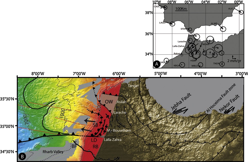
A. GPS velocity field with respect to the Africa plate from Tahayt et al., 2008. B. Morpho-tectonic framework with topography from SRTM3 and bathymetric complilation. See Fig. 5 for legend, red lines: SWIM* lineaments from Zitellini et al., 2009, BF: Blind front of the Prerifan nappes, SB: Satellite basin, RB: Rharb basin, OW: Outcroping wedge. *SWIM is the acronym of the ESF EuroMargins project “Earthquake and Tsunami hazards of active faults at the South West Iberian Margin: deep structure, highresolution imaging and paleoseismic signature”.
A. Champ de vitesses GPS par rapport à la plaque africaine d’après Tahayt et al., 2008). B. Schéma morpho-tectonique avec topographie SRTM3 et compilation bathymétrique. Voir Fig. 5 pour légendes, lignes rouges : linéaments SWIM* d’après Zitellini et al., 2009), BF : front aveugle des nappes prérifaines ; SB : bassin satellite ; RB : bassin du Rharb ; OW : prisme affleurant. *SWIM est l’acronyme du projet ESF EuroMargins Earthquake and Tsunami hazards of active faults at the South West Iberian Margin: deep structure, high resolution imaging and paleoseismic signature.
Offshore, the multibeam bathymetric coverage, available for the West-Rifan continental slope boarding the studied platform, shows the Gulf of Cadiz accretionary wedge formed by a juxtaposition of Triassic, Cretaceous and Cenozoic units. Further west, they overlap the Meso-Cenozoic domains and extend southward to the complex of the Prerif nappes (Gutscher et al., 2002; Flinch, 1993). The western deeper part of the accretionary wedge encloses curvi-linear ridges marking the surface expression of southwest, west and northwest vergent anticlinal folds and blind-thrusts imaged by seismic profilesand interpreted as being caused by east-west shortening driven by slab rollback (Gutscher et al., 2009a). Eastward, the upper part of the wedge forms two significant lobes, marked by the presence of numerous sub-linear fissures breaking the recent deposits into tectonic rafts. Compressive structures are also observed at the lower edges of the lobes and indicating in this case a gravity spreading of the superficial sedimentary cover (Gutscher et al., 2009b). These mechanisms are compatible with the curved flexures and faults observed on the shelf and whose concavity is oriented towards the west. They correspond to the upslope part of the gravity-spreading lobe characterised by an extensional fault system and pressure ridges. The active faulting observed on several seismic lines (section 3, Fig. 4) suggests ongoing activity of the gravity processes through the upper part of the accretionary wedge (Gutscher et al., 2009b). The presence of gravity sliding and growth faults was already mentioned by Flinch (Flinch, 1993) across the northern Rharb Basin. He described westward dipping listric faults associated to the setting up of the Prerifan nappes during Tortonian and imaged on industrial seismic profiles. The HR seismic data interpretation suggests that these gravity mechanisms are maintained, during the Pleistocene times and control by the reactivation of the large frontal Prerifan structures as shown by the uplift of the Neogene nappes and displacement along the Lallah Zarah fault zone. The structural importance of the Lalla Zahra area, also suggests, that this deformation corridor corresponds to a major Quaternary kinematic boundary in the western prolongation of the ENE-WSW trending Jebha fault which forms the southern limit of the internal Rifan domain bordering the Mediterranean side of the cordillera (Chalouan et al., 2001; Chalouan et al., 2006). This fault exhibits large sinistral displacement during the Miocene allowing the southwestward emplacement of the Rif nappes and partly accommodating the west-southwest movement of the Alboran block (Chalouan et al., 2006). The identified east-west continuation of the Lalla Zahra ridge seems, otherwise, incompatible with a major WNW-ESE SWIM (see Fig. 7 for acronym) lineaments described through the Gulf of Cadiz which may be connected to the buried inactive front of the Prerifan nappes (Zitellini et al., 2009). The geometry of the identified structures and the apparent transcurent motion deduced along the Lalla Zahra ridge are, however, compatible with the recent GPS measurements showing a current displacement toward the SSW of the central Rifan block with respect to an African fixed block at on average speed of 3.4 mm/yr (± 1.2 mm/yr) (Tahayt et al., 2008).
8 Conclusions
The new set of seismic data allows us to establish a link between the onshore and offshore observations conducted along the coastal area of the Rif cordillera and the adjacent southern part of the Gulf of Cadiz.
The seismic stratigraphy study covering the domain of the continental shelf corresponding to the western termination of the south Rifan front shows the existence of an important deformation affecting the sedimentary cover during Pleistocene times. This deformation does not involve the reactivation of the blind front of the Prerifan nappe, but concerns mainly the segment localized between the Lalla Zahra ridge and the outcropping Neogene nappes just north of Larache. The deformation corresponds to a succession of faults and ridges that defines a general arch-shape with westward open concavity.
They correspond to the upslope part of a gravity-spreading lobe characterised by extensional fault system and pressure ridges.
The identified gravity mechanisms are maintained during the Pleistocene times and controls by the reactivation of the large frontal Prerifan structures. The offshore continuation of the Lalla Zahra coastal structure corresponds to a major Quaternary kinematic boundary showing transpressive deformations; these observations are consistent with the hypothesis of its connection with the Jebha Fault.
Acknowledgments
The authors are very grateful to the reviewers Pr. Ahmed Chalouan and Pr. André Michard for their careful examination of previous version of this paper and for their helpful comments. They also thank the captains and the crew of the INSU/CNRS R/V “Côtes de la Manche” and the Moroccan vessel “Al Manar”, the technician and scientific colleagues for their participation in the project and the cruise: Jacques Begot, Denis Malengros, Alain Trenteseaux, Nadia M’Hammdi, Lahcen Aït Brahim, SiMohamed Mastere. The authors are also grateful to the Moroccan Office National des Hydrocarbures et des Mines (ONHYM). This research has been carried out within the Action Intégrée project MA/08/192 associated to the partenariat Hubert Curien Volubilis, the french ANR project Isis [Programme Catastrophes Telluriques et Tsunami] and the European project Nearest [Integrated observations from near shore sources of Tsunamis].