

1 Introduction
Tunisia as a whole, and the region of eastern Tunisia in particular, have great need of water resources and green energies in order to satisfy the future requirements in different economic sectors, especially in agriculture, tourism and power supplies. During the last decades, and especially in the last one, the exploitation of free aquifers in north-eastern Tunisia has attained its limits, with local failure of resources for irrigation. New water supplies are now needed. A particular attention is required in the immediate future to find sufficient resources of water for drinking, irrigation and the tertiary sector. In fact, and until now, no deep hydrogeological reservoirs have been characterised as exploration targets in Tunisia, whereas a set of subsurface data issued from previous petroleum exploration is available. We will outline the tectonic framework of the area combining subsurface and outcrop data. The subsurface data include seismic section interpretations, well-logging and geothermal measurements issued from petroleum wells. The interpretation of the data in terms of reservoir characterisations, as well as of the structural framework, will highlight the different hydrogeological sub-basins and the main potential fields for exploration-development of deep hydrogeological aquifers, which can attain average depths of more than −3000 m below sea level. Otherwise, little information is available on the deep hydrogeological structural configuration of the foreland and its relationship with the adjacent Atlas belt. However, important resources were recognized locally along the Chérichira-Kondar thrust system (Khomsi et al., 2004a, 2005, 2006). Our structural interpretations are also based on high-resolution regional seismic records tied to a set of petroleum wells. These seismic sections cross major buried subsurface structures and highlight the occurrence of important fractured reservoirs associated to the main structures.
2 Geological setting and stratigraphic distribution of potential reservoirs
2.1 Major geological domains of Tunisia
Tunisia can be structurally divided into five domains that are, from north to south (Fig. 1):
- • the Tell system relates to an accretionary prism developed in front of a continental backstop of European origin (exposed in the northern Tunisia offshore in La Galite Island,). The Tell is interpreted as an “Alpine” chain constituted by several thrust-sheets displaced from northwest to southeast (Burollet, 1991);
- • the Mejerda valley constitutes a complex structural area exhibiting Triassic salt plugs which were unroofed and displaced horizontally;
- • the Atlas belt constitutes a north-east-trending fold and thrust belt (Fig. 1). It is limited in its eastern and southern sides by the eastern Tunisia foreland called Sahel and by the Sahara platform, respectively. The boundary between the Atlas and its foreland is the South Atlas Front (Fig. 1b), which is an important emergent or buried thrust fault ensuring the thrusting of the Atlas on its foreland basin (Burollet, 1991; Frizon de Lamotte et al., 2000; Khomsi et al., 2004a);
- • the eastern Tunisia Foreland is composed of the Gulf of Hammamet, the Sahel plain (Fig. 1c) and the Gulf of Gabes to the south (Fig. 1b). This foreland domain represents, in fact, an important deformation zone with thrusting and folding (Khomsi et al., 2004b). Recently, it was demonstrated that this foreland has recorded the main Atlas events and Atlas-like structures buried beneath a thick Quaternary cover (Frizon de Lamotte et al., 2009; Khomsi et al., 2006, 2009a,b);
- • the Sahara platform, which corresponds to Paleozoic-Mezosoic basins (Burollet et al., 2000) is slightly folded, except in its northern part, that suffered local Cenozoic movements (Raulin et al., 2011).

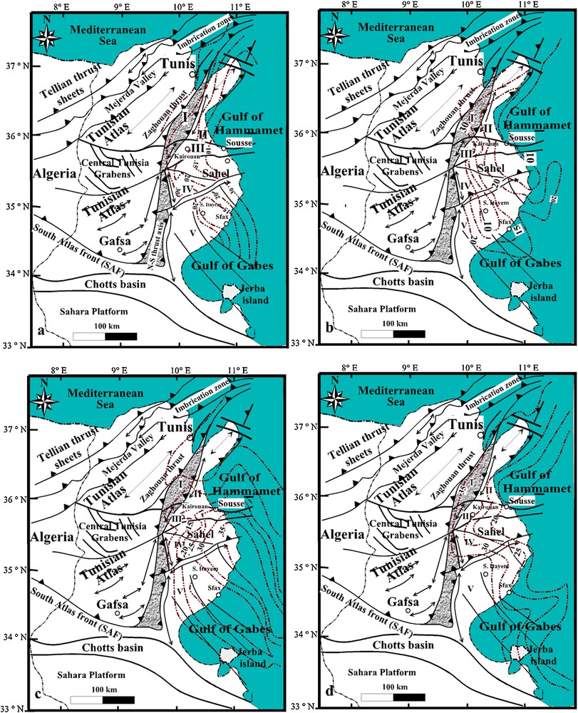
Location of the studied area in the Circum-Mediterranean region and general tectonic framework of Tunisia. a: geographic map of the Mediterranean area; b: tectonic summary map of Tunisia compiled from outcrop and subsurface data and situation of the study area of the Eastern foreland; c: major tectonic structures of the Sahel with the piezometric curves of the free aquifers compiled and modified from previous works (El Batti, 1974; Hamza, 1992). For Fig. 1b: a: structural domain of the north-south axis; b: major thrust; c: major fault; d: major anticline axis; e: regional cross-section along the major structures of North Tunisia compiled from subsurface and field data. I to V refer to structural subdivisions based on the structural framework. I: domain of the north-south axis; II: domain of Enfidha; III: domain of the flexural basin of Kairouan-Sousse; IV: domain of Chorbane; V: domain of the Sahel of Sfax. For Fig. 1c, springs with temperatures in °C: 1: 45 < T < 70; 2: 25 < T < 45; 3: T < 25. Note that the springs’ distribution is controlled by subsurface and outcropping faults.
Localisation de la région étudiée dans la zone circumméditerranéenne et cadre tectonique général de la Tunisie. a : carte géographique de la zone méditerranéenne ; b : carte tectonique simplifiée de la Tunisie compilée à partir de données d’affleurement et de sub-surface et situation de la région étudiée dans l’avant-pays oriental ; c : structures tectoniques majeures du Sahel, avec les courbes piézométriques des aquifères libres, compilées et modifiées à partir de travaux antérieurs (El Batti, 1974; Hamza, 1992). Pour la Fig. 1b : a : domaine structural de l’axe nord-sud ; b : charriage majeur ; c : faille majeure ; d : axe de l’anticlinal majeur ; e : coupe régionale le long des structures majeures du Nord tunisien, compilées à partir de données d’affleurement et de sub-surface. I à V correspondent à des subdivisions structurales, basées sur le bâti structural. I : domaine de l’axe nord-sud ; II : domaine d’Endfidha ; III : domaine du bassin flexural de Kairouan-Sousse ; IV : domaine de Chorbane ; V : domaine du Sahel de Sfax. Pour la Fig. 1c, sources de température (°C) 1 : 45 < T < 70, 2 : 25 < T < 45, 3 : T < 25. À noter que la répartition des sources est contrôlée par les failles affleurantes et de sub-surface.
Piezometric curves on Fig. 1c, redrawn and modified from El Batti, 1974; Hamza, 1992.
2.2 Stratigraphic overview of north-eastern Tunisia
Stratigraphy (Fig. 2) of the study area and generally of the Tunisia Atlas covers the Triassic-Quaternary time span and shows important stratigraphic hiatuses correlative to major tectonic events. The sedimentary cover of the Tunisian Atlas recorded major geodynamic stages (Fig. 2), which are related to the evolution of the Sirt basin (Frizon de Lamotte et al., 2009; Raulin et al., 2011).

Summary of the lithostratigraphical column of the eastern Atlas, seismic facies outlining the major lithologies packages and the main subsurface reservoir characteristics. Porosities are expressed in %, salinities in g/l, temperatures in °C.
Colonne lithostratigraphique simplifiée de l’Atlas oriental, faciès sismiques soulignant les lithologies majeures et caractéristiques des principaux réservoirs de sub-surface. Les porosités sont exprimées en %, les salinités en g/L et les températures en °C.
The lithostratigraphic column of the Atlas series shows a set of detachment levels in the sedimentary pile (Fig. 2). The most important is the Triassic evaporite due to its large extent and important thickness. A second important detachment level is located in the thick Early Cretaceous shales and marls.
Secondary detachment levels are located in the Upper Cetaceous shales, and Paleocene and Middle-Late Eocene shales, respectively (Fig. 2). These detachment levels played a dominant role in the control of the structural style during the Paleocene-Eocene positive inversions, related to what is known as the Atlas compressional phases, as well as during the so-called Alpine compressional phases extending from the Late Miocene to the Recent (Khomsi et al., 2004a, 2006, 2009b).
2.3 Main structural domains of north-eastern Tunisia
Based on previous works on the area (Khomsi et al., 2004a,b, 2006), the north-eastern Tunisia foreland can be subdivided into five structural domains delimitated by major faults separating different structural styles and sub-basin behaviours (Fig. 1b and c).
The structural domain I (Fig. 1b and c) encompasses the north-south axis and the Zaghouan thrust system to the northwest. This domain separates the Atlas eastern foreland from the Atlas orogenic domain along the south Atlas front (SAF). It corresponds essentially to a fold-thrust system in the front of the Atlas (Khomsi et al., 2004a, 2006), constituted by two well-known deformation trends in Tunisia: the Zaghouan thrust fault to the north; and the N-S thrust axis to the south (Fig. 1b and c). The Zaghouan thrust (Turki, 1980), as well as the north-south axis, are materialised by the thrusting of Jurassic strata over Eocene and Oligo-Miocene series (Jauzein and Perthuisot, 1981; Turki, 1980).
The domain II (Fig. 1b and c) corresponds roughly to the Cenozoic platform domain of Enfidha. It is characterised by a set of east-west to NW-SE grabens filled locally by huge Miocene to Quaternary sedimentary packages lying locally on top of Cretaceous strata (Saadi, 1997). It corresponds also to a domain of buried thrusts along the Cherichira-Kondar triangle zone in front of the Atlas, where the easternmost thrusts over-riding the Eastern platforms are blind (Khomsi et al., 2006).
The domain III (Fig. 1b and c) corresponds roughly to the Kairouan-Sousse flexural basin (Khomsi et al., 2004a, 2009a). This basin recorded more than 8000 m of post-Permian deposits and corresponds to a weak tectonic area subsiding since the Jurassic and recording all the major geodynamic events of the Atlas. It is limited by the Kairouan-Sousse fault to north and the El Hdadja fault to south (Khomsi et al., 2004a).
The domain IV (Fig. 1b and c) corresponds to the Chorbane-Sidi El Hani platform. It is characterised in the subsurface by Triassic salt diapirs controlling differential subsidence of the Meso-Cenozoic series. In the subsurface it shows essentially Triassic salt-cored anticlines, salt domes and fault-propagation folds (Khomsi et al., 2009a).
The domain V (Fig. 1b and c) corresponds to the Sahel of Sfax. It is usually characterised by Mesozoic platform series and thin Paleogene series. From the structural point of view it corresponds to large curvature anticlinoriums controlled by deep-seated faults and covered by the Cenozoic series with progressive onlaps from east to west.
2.4 Main geodynamic events of north-eastern Tunisia
In the Eastern foreland of the Tunisian Atlas (Pelagian domain), subsurface data show the existence of structural positive inversion leading to ramp-related folds developed over former normal faults. These normal faults were likely inherited from the Sirt rifting, which lasted from Lower Jurassic to Cretaceous (Bedir et al., 2001; Ben Ferjani et al., 1990; Raulin et al., 2011; Soussi, 2000; Turki, 1980). Growth strata indicate that positive inversion began during the Late Cretaceous and acted continuously through Paleocene and Eocene times (Frizon de Lamotte et al., 2009; Khomsi et al., 2009a,b). Therefore a major unconformity separates the Oligocene and younger sedimentary rocks from the underlying strata. It is significant of a complete change of the tectonic and sedimentary contexts (Frizon de Lamotte et al., 2000, 2009; Khomsi et al., 2009a,b). In fact, the sedimentary rocks turned from carbonate/shaly to detrital deposits (Khomsi et al., 2006; Yaich, 1997) and the tectonic regime became dominated by strong subsidence and normal faulting in the Atlas domain (Frizon de Lamotte et al., 2000).
A second compressive event post-dating the Upper Miocene (Frizon de Lamotte et al., 2000) is well expressed along the South Atlas Front. The effects of this second event remain weak in the eastern foreland of the Atlas system but are of major importance in the Atlas belt itself.
2.5 Main reservoirs of north-eastern Tunisia
The main reservoirs (Fig. 2) of north-eastern Tunisia are represented by a set of lithostratigraphical packages, which can be summarised as follows.
The Jurassic (Fig. 3) package is especially made up of dolomites and carbonates (Soussi, 2000), with differences in thickness distributions controlled by faults. This reservoir shows important porosity and permeability values, especially at places where it crops out on the crest of the Atlas range (Fig. 3). In fact, the Jurassic series constitutes the highest topographic culminations in Eastern Tunisia where it is typically a karst reservoir with high hydrodynamic capacities, formerly exploited by Roman and Carthaginian civilisations. The Jurassic limestones overhang tectonically the Late Cretaceous-Palaeogene series, which are mainly the major contributors to the deep hydrogeological resources of eastern Tunisia.

Field pictures of the Jurassic limestones cropping out along the Zaghouan thrust system. a: general view of the Jurassic dolomites overhanging tectonically the Oligocene sand bars in Jebel Fkirine. Note that the Jurassic limestones occupy the highest topographic positions and intercept directly waters from elevated clouds; b: panorama view showing the fractured Liassic series affected by normal faults and overhanging tectonically by a subhorizontal thrust fault the Campanian Maastrichtian limestones; c: details of the fractures affecting the Liassic limestones; d: general view of the Jebel Zaghouan covered by clouds at the end of the summer, e: examples of collapse affecting the Jurassic limestones of Jebel Zaghouan; f: a view of the Temple des Eaux (water temple) with artificial karst conduits connecting the faults of Jebel Zaghouan which appears here with its Grand Pic at 1295 m. Water temple is a Romain hydraulic engineering construction built 2000 years ago and still functioning nowadays with an average flow of 40 l/s with salinities less than 0.6 g/l.
Photographies des calcaires jurassiques affleurant le long du système de charriage de Zaghouan. a : vue générale des dolomies jurassiques surplombant tectoniquement les barres sableuses oligocènes du Jebel Fkirine. À noter que les calcaires jurassiques occupent les positions topographiques les plus hautes et interceptent directement l’eau en provenance des nuages élevés ; b : vue panoramique montrant les séries liasiques fracturées, affectées par des failles normales et surplombant tectoniquement, par une faille chevauchante subhorizontale, les calcaires campano-maastrichtiens ; c : détails des fractures affectant les calcaires liasiques ; d : vue générale du Jebel Zaghouan sous une couverture de nuages, à la fin de l’été ; e : exemple de collapse affectant les calcaires jurassiques du Jebel Zaghouan ; f : vue du château d’eau « Temple des eaux » avec des conduits karstiques artificiels connectant les failles du Jebel Zaghouan qui apparaît ici avec son Grand Pic à 1295 m. Le château d’eau est un ouvrage hydraulique romain, édifié il y a 2000 ans et qui fonctionne encore actuellement avec un flux moyen de 40 L/s et des salinités inférieures à 0,6 g/L.
Among all reservoirs the fine Campanian-Maastrichtian limestones of the Abiod Formation (Fig. 4) are of first importance as reservoirs for oil (Amiri-Garoussi and Beck, 1998; Beck et al., 2002; Ben Brahim, 1993) and water. For the petroleum resources the well-known Sidi El Kilani field has produced more than 25 000 barrel per day for several years. This major reservoir has porosities of 3% when not fractured, but its porosity can attain 30% in fractured areas and damaged zones associated to faults in the subsurface. It is also a krastified reservoir (Negra, 1998; Negra and M’rabet, 1991) both in outcropping (Fig. 4) and buried structures (Amiri-Garoussi and Beck, 1998; Beck et al., 2002; Ben Brahim, 1993; Negra, 1998; Negra and M’rabet, 1991).
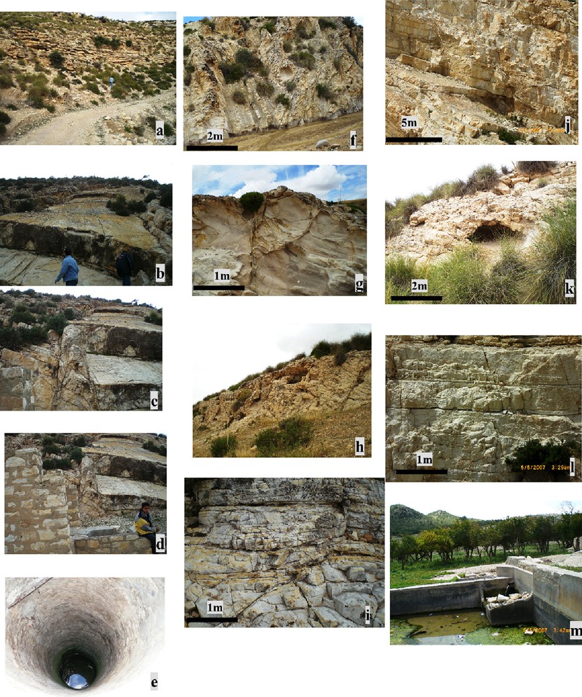
Many aspects of fracturation of the Campanian-Maastrichtian limestones reservoirs as they crop out in Zaghouan-Enfidha area. a: general view of the base of the series; b: conjugated open fracture joints; c: a fault core view of a normal fault gouge; d: the same fault damage zone as on c with a borehole drilled in the fault core by a land owner; e: detail of the borehole and the water table 2 m below observer for the same fault; f: fracturation and karstification of the limestones; g: example of flower structures fracturation; h: open cavities; i: examples of distribution of intense fracturation on decimetric layers and percolated open fractures with a typical yellow-brownish coloration; j: aspects of fracturation and jointing above a thrust fault affecting the series; k: metric cave in the Campanian karstified limestones; l: example of joint fracture distribution in a low fractured section; m: a drinkable water spring (0.6 g/l) in the Campanian limestones exploited and cited since the Romain epoch in the Enfidha area and called Ain Rehma flowing with a rate of 10 l/s.
Différents aspects de la fracturation dans les réservoirs des calcaires campano-maastrichtiens, tels qu’ils affleurent dans la région de Zaghouan-Enfidha. a : vue générale de la base de la série ; b : joints de fractures ouvertes conjugués ; c : vue d’un cœur de faille dans une brèche de faille normale ; d : zone broyée de la même faille qu’en c, avec un puits creusé dans le cœur de la faille par un propriétaire terrien ; e : détail du puits et nappe phréatique 2 m au-dessous l’observateur, pour la même faille ; f : fracturation et karstification des calcaires ; g : exemple de fracturation en structures en fleur ; h : cavités ouvertes ; i : exemples de distribution de fracturation intense dans des lits décimétriques et fractures ouvertes percolées, de couleur jaune brunâtre typique ; j : aspects de fracturations et de joints au-dessus d’une faille chevauchante affectant la série ; k : grotte métrique dans les calcaires karstifiés campaniens ; l : exemple de distribution de joints dans une section faiblement fracturée ; m : source d’eau potable (0,6 g/L) dans les calcaires campaniens exploités et cités depuis l’époque romaine dans la région d’Enfhida sous le nom d’Ain Rehma coulant à 10 L/s.
The Upper Ypresian limestones are also important carbonate reservoirs. They are well-developed in the subsurface as well as in the outcropping (Fig. 5) areas along the north-south axis and the Zaghouan thrust system. They are made up of fine Globigerina limestones and porous Nummulitic pack-wackestones which are locally highly fractured (Negra and Merdassi, 2000). In many places, this reservoir rests directly on top of Campanian limestones with a hiatus of the Paleocene shales, inducing a high rate of communication between the circulating fluids in the two reservoirs as evidenced locally in many wells (Amiri-Garoussi and Beck, 1998; Beck et al., 2002; Smaoui et al., 1998).

Many aspects of fracturation of the Ypresian limestones cropping out in Zaghouan and Enfidha area. a: a general view of the section; b: aspects of fracturation in the lower part of the series. Here a normal fault affecting an anticline on its backlimb; c: large conjugated strike-slip faults affecting the limestones on a perched syncline; d: open fractures in the transported hanging wall of a thrust affecting the base of the series. Note the listric faults in the hangingwall and change in the fracturation intensity between the footwall and hanging wall of the thrust; e: general aspects of fracturation, f: a drinkable water spring (Ain Houssa) flowing and emerging from the syncline with an average flow of 27 l/s.
Différents aspects de la fracturation dans les calcaires yprésiens affleurant dans la région de Zaghouan et d’Enfidha. a: vue générale de la coupe ; b : aspect de la fracturation dans la partie inférieure de la série. Ici, une faille normale affecte un anticlinal sur son flanc normal ; c : grandes failles décrochantes conjuguées affectant les calcaires sur un synclinal perché ; d : fractures ouvertes sur le compartiment chevauchant transporté d’un charriage affectant la base de la série. À noter les failles listriques dans le compartiment chevauchant et le changement d’intensité de la fracturation entre le compartiment chevauché et le compartiment chevauchant du charriage ; e ; aspects généraux de la fracturation ; f : source d’eau potable (Ain Houssa) coulant et émergeant du synclinal avec un flux moyen de 27 L/s.
The Oligocene-Miocene (Figs. 6 and 7) reservoirs are widespread spatially and have high hydrodynamic capacities in the subsurface (Hamza, 1992; Khomsi, 2005). They correspond chiefly to foredeep deposits with two major deltaic systems. Stratigraphic (Saadi, 1997; Yaich et al., 1994), sedimentological works on these series combining surface (Saadi, 1997; Yaich, 1997) and subsurface investigations (Chebbi, 2007; Khomsi, 2005) allowed us to highlight the occurrence of five sand and carbonates bars located in the Miocene and the Oligocene series, respectively (Fig. 6). High-resolution seismic data and well-logging interpretations allowed us to trace the spatial distribution of these reservoirs (Fig. 6).

Lithostratigraphy of the Oligocene deltaic series, main reservoirs and sketches of the main reservoirs and fracturation aspects. a: general cross-section in the front of the Zaghouan thrust together with field photos of reservoirs and well logging signature (here Sonic). Note the occurrence of five potential reservoirs separated by thick shale layers. Sketches show field details of reservoirs; b: general view of the base of the series; c: highly fractured carbonate sandstone reservoir R1 at the base of the series; d: open fractures affecting reservoir R2 with precipitation of minerals along fractures concentrating flow of hydrothermal waters; e: normal faults affecting the sand bars of reservoir R3; f and g: distribution of open fractures which seem to have an homogenous distribution horizontally for reservoir R3; h: dissolution cavities affecting the reservoir R 5 and due to dissolution of carbonates cements; i: detail of the precedent sketch. Map on the upper left side of figure gives positions.
Lithostratigraphie de la série deltaïque oligocène, principaux réservoirs et schéma des principaux réservoirs et des aspects de la fracturation. a : coupe générale en avant du charriage de Zaghouan, avec des photos de terrain des réservoirs et la signature diagraphique (ici acoustique). À noter l’existence de cinq réservoirs potentiels, séparés par d’épais lits argileux. Des schémas montent des détails de terrain de ces réservoirs ; b : vue générale de la base de la série ; c : réservoir gréso-carbonaté R1, intensément fracturé, à la base de la série ; d : fractures ouvertes, affectant le réservoir R2, avec précipitation de minéraux le long de fractures concentrant le flux d’eaux hydrothermales ; e : failles normales affectant les barres sableuses du réservoir R3 ; f et g : distribution des fractures ouvertes qui semblent avoir une répartition homogène horizontalement pour le réservoir R3 ; h : cavités de dissolution affectant le réservoir R5 et dues à la dissolution de ciments carbonatés ; i : détail du schéma précédent. La carte en haut à gauche de la figure donne les localisations.
For Fig. 6a the log section is modified from Saadi, 1997.

Isothickness maps at the whole scale of Eastern Tunisa corroborating the important thicknesses and spatial extents for the Campanian-Maastrichtian limestones (a), the Ypresian limestones (b), the Oligocene (c) and finally Miocene deltaic series (d). 1: major synclines; 2: major anticlines; 3: isothickness curve; 4: major fault; 5: no deposits or erosion.
Cartes d’isoépaisseurs à l’échelle d’ensemble de l’Est tunisien, corroborant les importantes épaisseurs et l’extension spatiale pour les calcaires campano-maastrichtiens (a), les calcaires yprésiens (b), les séries deltaïques oligocènes (c) et miocènes (d). 1 : synclinaux majeurs ; 2 : anticlinaux majeurs ; 3 : courbe isopaque ; 4 : faille majeure ; 5 : aucun dépôt ou érosion.
Isothickness (Fig. 7) maps at the scale of north-eastern Tunisia for the Campanian-Maastrichtian limestones, the Ypresian limestones, the Oligocene and Miocene series, respectively, show that these series are well-developed in the entire foreland domain especially in the above cited structural domains I, II, III and IV. Among all reservoirs those of the Oligocene and Miocene series have high cumulative thicknesses, which reach locally more than 3200 m (Fig. 7).
Porosity maps (Fig. 8) were tentatively drawn, based on many previous works (Chulli-Zenati, 1999; Khomsi, 2005) and up to 500 available petroleum wells. We should notice here that these values constitute a qualitative order of magnitude of the porosities, because the interpretation of the porosity values from oil wells, with respect to their hydrogeological meaning, remains difficult. In fact, the efficient porosity or storage coefficient determined usually from hydraulic tests (pumping tests) in hydrogeology are in other orders of magnitude for confined aquifers compared with the values and extrapolation obtained from oil wells. Otherwise scarcity of data on the efficient porosities for the deep subsurface saturated water reservoirs (our main purpose) is still a limiting factor to undertake precise calculations of reserves and movable water resources. On the other hand, petroleum exploration does not focus tests on purely water reservoirs. Further studies would be required to ensure better knowledge of these reservoirs by means of hydrogeological pumping tests on many buried hydrogeological prospects. Finally, the total porosity maps constitute an important tool to investigate potential prospects. From this point of view, the maps (Fig. 8) show that the four main reservoirs have moderate to high porosities. Locally, high porosities are related to fault corridors and extensional tectonic on the crest of collapsed anticlines. A general tendency for increasing porosities from west to east is particularly evident for these reservoirs and may be related to intense fracturation along the outcropping structures (Figs. 3–6 and 8).
Summary maps of the average porosities expressed in %. a: campanian-Maastrichtian reservoir; b: ypresian limestones reservoirs; c: oligocene uppermost reservoir (R5); d: miocene uppermost reservoir (R5). The data are issued from 450 wells in eastern Tunisia.
Cartes simplifiées des porosités moyennes exprimées en pourcentage. a : réservoir campano-maastrichtien ; b : réservoirs calcaires yprésiens ; c : réservoir oligocène R5 supérieur ; d : réservoir miocène R5 supérieur. Les données proviennent de 450 puits de l’Est tunisien.
Modified from Ben Dhia et al., 1992a and Chulli-Zenati, 1999 for a, b and c.
The interpretations of seismic sections presented below are in accordance with these interpretations.
Additionally, along the structural domain I and II the reservoir series crop out on a surface of more than 13 000 square kilometres in a structural setting characterised by high fracturation (Khomsi et al., in course). Therefore, these reservoirs can intercept and directly store huge quantities of waters from direct rainfall. Many authors (El Batti, 1974) consider that water infiltration along Zaghouan thrust amounts up to 15% of the total rain.
3 Control of the piezometry by the structural subsurface configuration
A piezometric map (Fig. 1c) of the Northern Sahel was compiled using all available published data (El Batti, 1974; Hamza, 1992). The inferred underground flows seem to be highly controlled by the deep structural configurations and the major subsurface faults. In fact, in the northwest and in the southeast, the dominant flow is from northeast to southwest, being thus parallel to the Cherichira-Kondar fault (Fig. 1c), which seems to act as major barrier flow. The underground water west of Kondar is sourced from the outcropping structures in the footwall of Jebel Zaghouan thrust. Here it is obvious that the incoming water is issued from under-flow through the fractured outcropping reservoirs.
Interpretations of high-resolution seismic data, in terms of structural transects are in agreement with the flow configuration. Two sections (Figs. 9 and 10), cutting orthogonally the Cherichira-Kondar thrust system, allow visualising clearly the deep configuration. The first section (Fig. 9) shows the different sub-basins along the section with particularly two major fault propagation anticlines detached along the basal Triassic salt decollement. Both anticlines are limited on their forelimb by east-verging thrusts. Otherwise the section shows that the Late Cretaceous-Miocene series are developed along the section together with important fracturation on the crests of the two visualised ramp anticlines.
Interpretative structural transect of high-resolution seismic section crossing the northern part of the area III of Enfidha flanking the outcropping structures in the footwall of Zaghouan thrust (position on Fig. 1c) and cutting the buried Atlas front. The section depicts the fault of Cherichira Kondar and the different sub-basins in an east-west direction. Note the faults affecting the Miocene and Oligocene reservoirs subcropping on the crest of the ramp related anticlines. LC: Late Cretaceous; C-P: Campanian-Paleocene; Yp: Lower Eocene.
Interprétation structurale d’une section sismique haute résolution du charriage de Zaghouan (localisation sur la Fig. 1c) traversant la partie nord de la région III d’Enfidha flanquant les structures affleurantes dans le compartiment chevauché et recoupant le front atlasique enfoui. La coupe montre la faille de Cherichida- Kondar et les différents sous-bassins dans la direction est-ouest. À noter les failles affectant les réservoirs oligocènes et miocènes sub-affleurant au sommet des anticlinaux en liaison avec le talus. LC : Crétacé supérieur ; C-P : Campanien-Paléocène ; Yp : Éocène inférieur.
Modified from Khomsi et al., 2009a.

Interpretative structural transect of high-resolution seismic section crossing the N-S axis (position on Fig. 1c) cutting the buried Atlas front of Chérichira-Kondar and reservoir identification for the Oligocene series. a: interpreted seismic section; b: oligocene reservoir configuration along the section deciphering reservoir distribution. Note that the five Oligocene reservoirs are fully fractured. LC: Late Cretaceous; C-P: Campanian-Paleocene; Yp: Lower Eocene.
Interprétation structurale de la section sismique haute résolution traversant l’axe nord-sud (localisé sur la Fig. 1c), recoupant le front atlasique enfoui de Cherichira-Kondar et identification de réservoirs dans la série oligocène. a : section sismique interprétée ; b : configuration du réservoir oligocène le long de la coupe mettant en évidence la distribution des réservoirs. À noter que les cinq réservoirs oligocènes sont totalement fracturés. LC : Crétacé supérieur ; C-P : Campanian-Paléocène ; Yp : Yprésien.
Fig. 10a modified from Khomsi et al., 2009a.
The second section (Fig. 10) recorded near the southern border of the area I intersects also the buried thrust structures of Chérichira-Kondar (Fig. 10) and crosses the subsurface buried thrust front of the Eastern Tunisian Atlas in its southern part. It is tied to the laterally projected petroleum well Kfb that encountered a complex tectonic zone with a repeated section of Upper Cretaceous series separated by Triassic salt bodies injected along thrust faults (Khomsi et al., 2006, 2009a). This section displays, in its median part, the anticline of Draa Souatir-Kondar, which corresponds geometrically to a fault-propagation fold. As outlined in the precedent section (Fig. 9), the Kondar structure is bordered eastward by a thrust ramp, which is branched at depth on the Triassic salt forming the basal décollement level (lower flat). Upward the ramp is branched on an upper flat, located within the Middle-Upper Eocene marls. Secondary thrust-faults cut out the forelimb of the anticline. They correspond to break-through faults branched on the ramp. This is indicated by the thickening of the stratigraphic series westward in the Sbikha basin where the late Cretaceous-Miocene reservoirs are developed with important thicknesses.
Underneath the Sbikha syncline, on the western border of the section (Figs. 9 and 10), we note an angular unconformity of Eocene horizons above folded Late Cretaceous strata with erosion of Palaeocene shales on the crest of an inverted buried structure at depth of about −2500 m. Many boreholes drilled on the crests of the anticlines intercepted high flow rates of good waters in the uppermost part of the Oligocene series which crop out west of Kondar. Locally, flow rates at the crest are as high as 200 l/s with an average total salinity of 1.5 g/l, despite the fact that the boreholes are shallow holes, which are no deeper than 150 m. This points to important water resources in this area. Accordingly lithological reservoir determinations (Fig. 10b and c) were tentatively made, based on inversion of seismic parameters and precise lithological picking of the seismic facies. The obtained configuration concerning the Oligocene series shows that the Oligocene presents important thicknesses of about 1000 m, with the development of five potential sand reservoirs highly fractured west of Kondar (Fig. 10b and c). Differences in configuration of reservoir geometries are outlined along this section and are related to original differences in sedimentary environments, despite the fact that the same number of reservoirs were clearly highlighted in Sbikha and Kelbia synclines (Fig. 10b and c).
In the area III (Fig. 1b), in the flexural basin of Kairouan Khomsi et al. (2004a) the flow is dominantly from southwest to northeast, being sourced from Sebkha El Kelbia and Sousse in the northern edge of the Kairouan-Sousse fault. A centrifugal centered underground flow around Sousse-Monastir is clearly identified in the east and west direction (Fig. 1c). The inferred configuration is corroborated by structural analysis based on a seismic section cutting this area (Fig. 11). Structural interpretation (Fig. 11) allowed us to visualize and define the main structures in this part of Kairouan basin. Particularly the anticline megastructure of Sousse-Monastir which ensures underground flow centered around Sousse and alimentating the basins located to the north and to the south. The anticlinorium of Sousse (Fig. 11) seems to be a high structural area limited towards the north by the Kairouan-Sousse fault, which is clearly visualised on the section and materilised by tilted panels (Fig. 11) affecting the Cretaceous-Paleogene series. On the other hand, we can notice also the development of an important fault system at the crest of the anticline leaking different reservoir panels (Fig. 11) and presumably ensuring deep flow and communications between reservoirs of different ages and lithologies (Fig. 11). The underground flow detected on the piezometric map is also induced by the dip of the reservoirs. From this point of view the fault of Kairouan-Sousse subcrops in the axial area of the anticlinorium (Fig. 11) and can therefore be considered as an important drain system recharged by infiltration from surface waters and rain. In fact, we have identified many springs along the fault trace around Sousse town flowing in the Upper Miocene sands.

Interpretative structural transect of high-resolution seismic section positioned on Fig. 1c, cutting the section in the domain III at the eastern border of the flexural basin of Kairouan. Note the anticline megastructure of Sousse, which ensures centripete underground flow centered around Sousse and recharging the basins located to the north and to the south. Note also the development of an important fault system on the crest of the anticline leaking different reservoir panels and ensuring deep flow. CM: Campanian-Maastrichtian; Pa: Paleocene; Yp: Ypresian.
Interprétation structurale de la section sismique haute résolution localisée sur la Fig. 1c, recoupant la section dans le domaine III de la bordure orientale du bassin flexural de Kairouan. À noter la mégastructure anticlinale de Sousse qui assure l’écoulement souterrain centripète centré autour de Sousse et rechargeant les bassins situés au nord et au sud. À noter aussi le développement d’un important système faillé au sommet de l’anticlinal, drainant différents panneaux du réservoir et assurant l’écoulement en profondeur. CM: Campanien-Maastrichtien ; Pa : Paléocène ; Yp : Yprésien.
Modified from Khomsi et al., 2009a.
4 General geothermal characteristics related to deep architecture
Many previous works by Ben Dhia et al. (1992a,b), Bouri et al. (2007) allowed outlining the main geothermal framework of Eastern Tunisia. Some interesting maps were presented issued from the compilation of the different data of temperature measurements in the Foreland basins (see, for review, Ben Dhia, 1983, 1988, Ben Dhia et al., 1992a,b). Many other authors (Bedir et al., 2001; Burollet et al., 2000; Chulli-Zenati, 1999; Mejri et al., 2006) presented summary maps related to deep geothermal gradients and temperatures. Among all of them, the maps deciphering the temperature at depth of 1500 m are more important because this depth corresponds roughly to the average depth below sea level of the Late Cretaceous-Oligo-Miocene series (−1500 to −2000 m). The maps (Burollet et al., 2000) shows the occurrence of a an anomalous hot zone at depth −1500 with a high temperature of 90 °C centered on the Sidi- Il Itayem-Sfax area with a general NW-SE trend oblique on the Atlas major structure folds which are essentially east to northwest trending in the area. Otherwise, it is highly interesting to confront the temperature curves with the main oil fields in the area. In fact and following Ben Dhia (1988), Ben Dhia et al. (1992a, b), it seems that many petroleum fields can be correlated to geothermal anomalies. The Sid El Itayem-Sfax area (Ben Ismail et al., 1994) is an example. Otherwise, this area is also an area of Mesozoic and Cenozoic volcanic activity, which is supported by many exploration wells in the area (Mattoussi et al., 2008, 2009).
Different maps of the temperatures measured in top formations show important features (Fig. 12). For all formation tops, temperatures increase from NW to SE and west to east, i.e. from the Atlas towards the Pelagian rifts offshore. Otherwise for the the Campanian-Maastrichtian top the highest temperatures are measured in the structural area V in the onshore near Sfax and centered south-eastward in the offshore of Sfax (Fig. 12a). The area III is also a zone of high temperatures.

Temperature of top formations. a: campanian-Maastrichtian reservoir; b: ypresian limestones reservoirs; c: oligocene reservoirs (R5); d: miocene reservoirs (R5). a: South Atlas Front domain, b: major thrust; c: major fault; d: major anticlines; e: isotemperature curves in °C.
Température dans les formations sommitales. a : réservoir campano-maastrichtien ; b : réservoirs calcaires yprésiens ; c : réservoirs (R5) oligocènes ; d : réservoirs (R5) miocènes ; a : domaine du front sud-atlasique ; b : charriage majeur ; c : faille majeure ; d : anticlinaux majeurs ; e : courbes d’isotempérature en °C.
Modified from Ben Dhia et al., 1992a and Chulli-Zenati, 1999 for a, b and c.
For the Ypresian top formation (Fig. 12b), the highest temperatures are measured in the area V of Sid-Il Itayem-Sfax centered onshore (Fig. 12b). The isovalue curves suggest that the distribution is controlled by the NW-SE faults cutting the buried offshore and onshore structures. These faults pertain to the Sirt rift system and are oblique to other major Atlas-type structures (Frizon de Lamotte et al., 2009; Khomsi et al., 2009a).
For the Oligocene top reservoir (Fig. 12c), the highest temperatures are measured also in area V of Sidi- Il Itayem-Sfax with an anomaly striking NW-SE, centered in northern Sfax onshore, its major part extending in the southern Sfax offshore.
For the Miocene we note a migration of the thermal anomaly from onshore Sfax towards the offshore east of Sfax (Fig. 12).
The temperatures are especially high for the top Maastrichtian reservoirs and top Ypresian reservoirs, in contrast to the temperature values at the top of Oligocene and Miocene reservoirs. On the other hand, the anomalous high temperatures areas for the four formation tops are not centered geographically in the same position.
5 Discussion
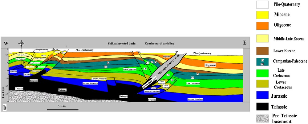
We have summarized our interpretations and discussions with a structural cross-section throughout the onshore foreland of eastern Tunisia in the south-east and part of the northern domain west of the Zaghouan thrust system (Fig. 13). This cross-section striking NW-SE cuts the major outcropping and buried structures from the Mejerda valley south of the Chorbane structure in the south-east (Fig. 13) and deciphers the structural style, major structures of the region, with particular emphasis on communication between sub-basins (Fig. 13). The structural style is dominated by thrusting in the north-western part in the Jebel Zaghouan thrust, where Jurassic-Lower Cretaceous rocks overlie the Sibkha footwall syncline (Fig. 13). Towards the south, the Kondar anticline is thrusted over the Kelbia syncline. The thrust-fault is underlined by Triassic salts (Fig. 13). Further south, the folded structures, sealed by the Oligo-Miocene series, are typical of faulted structures observed in the Sahel connecting different compartments vertically. These structures are recharged by rainfall and surface water flow (Fig. 13).

General cross-section through the studied area compiled from outcrop observations, subsurface data and previous works deciphering the structures, major deformation features, gravimetric curve of the anomaly of Bouguer, temperatures at −1000 m, −1500 m and −2000 m below sea-level, respectively, and the main provinces areas for exploration with an outline of prospectivity and resources importance. See text for comments. Position on Fig. 1b. P1 to P8 refer to exploration provinces. a: limits of the provinces; b: rainfall intensity; c: underground flow directions; d: increasing fractured aquifer communications upwards; e: increasing fractured aquifer communications downwards; f: relative importance of geothermal prospectivity and occurrences of important geothermal incomes; g: relative importance of occurrences of waters for irrigation (salinities < 6 g/l); h: relative importance of occurrences of drinkable waters (salinities < 2.5 g/l). Height of rectangle is proportional to importance.
Coupe générale à travers la région étudiée, compilée à partir d’observations sur affleurement, de données de sub-surface et de travaux précédents mettant en évidence les structures, les caractéristiques des déformations majeures, la courbe gravimétrique de l’anomalie de Bouguer, les températures à −1000 m, −1500 m, −2000 m au-dessous du niveau de la mer respectivement et les principales provinces à explorer du point de vue des potentialités et de l’importance des ressources. Voir texte pour les commentaires. Localisation sur la Fig. 1b. P1 à P8 correspondent aux provinces d’exploration. a : limites des provinces ; b : intensité des précipitations ; c : directions d’écoulement souterrain ; d : accroissement vers le haut, des communications de l’aquifère facturé ; e : accroissement vers le bas, des communications de l’aquifère fracturé ; f : importance relative des potentialités géothermiques et existence d’importantes venues géothermiques ; g : importance relative d’occurrences d’eaux d’irrigation (salinités < 6 g/L) ; h : importance relative d’occurrences d’eau potable (salinités < 2,5 g/L). Hauteur de rectangle proportionnelle à l’importance.
The curves of temperatures plotted for depths of −1000 m, −1500 m and −2000 m, are essentially measured in petroleum exploration wells. Knowing that major petroleum exploration and development wells in NE Tunisia are essentially drilled on the crestal part of major anticlines (Khomsi, 2005), we have to admit that the measured temperatures should be higher than what is reported in adjacent synclines and fractured grabens flanking the petroleum traps, where the series are thicker. Anyway, these tendencies are outlined by the curves. In particular, a general increase of the geothermal gradient is observed from NW to SE together with increasing temperatures in the same direction (Fig. 13). However, the temperatures curves do not depict the same variations and tendencies locally. In fact, there is a great coherence in the tendencies of the temperatures curves of −1000 and −1500 m. Compared to the curve of temperature at −2000 m, many differences arise with locally opposite tendencies. This statement can be understood if we admit that the aquifers between −1500 and −2000 m are not communicating vertically. Therefore these differences allow us to decipher eight hydrogeological-geothermal provinces based not only on geothermal features but also on a set of parameters including chemistry (beyond the purpose of this work) of waters (El Batti, 1974; Hamza, 1992) and reservoir characteristics. In fact, the definitions of these provinces are in accordance with the tendencies of the temperature curves. In fact, if temperature tendencies are opposite and divergent in depth despite the fact that the geothermal gradient curve is constantly increasing, it is likely due to lack of vertical communication downwards between the superposed reservoirs. This assumption allows us to define qualitative gradients of communications involving circulating waters through deep reservoirs. It appears that the provinces P2, P3, P 4 P6 and P7 (Fig. 13) correspond to areas of decreasing communication downwards for reservoirs between depth of −1500 and −2000 m, in contrast to provinces P5 and P8, which seem to be areas of increasing reservoir communication downward.
On the other hand, many increases of temperatures at depth of −2000 m can be correlated to the uplift of the Pre-Triassic basement as in the footwall of Zaghouan thrust and in the southern edge of Chorbane. In particular, this latter area lying on Sidi-Il Itayem-Sfax (province P8) seems to be the most prolific area for geothermal purposes of middle to high enthalpies. For instance, temperatures at depths of −2000 m reached 140 °C and many exploration development oil wells tested high flows of waters with temperatures of 150 °C in the Eocene limestones reservoirs and the Oligo-Miocene series with average flows of 160 l/s for many wells with very high salinities reaching 100 g/l. These waters seem to be linked to drainage flows of oil (Ben Ismail et al., 1994) reservoirs, which can transfer a large amount of heat. Otherwise, the P8 province seems to be the setting of Tertiary volcanic activities materialised by intrusive volcanic material in many Cretaceous series intruded along deep-seated faults (Burollet et al., 2000; Mattoussi et al., 2008, 2009).
It is questionable whether the occurrence and developments of such an anomalous province is related to the uplift of the Pre-Triassic basement or to activities of normal deep-seated faults during the Oligo-Miocene and the Quaternary. Anyway, this area was impacted by the opening of the Pantelleria-Linosa-Malta rift systems during the Miocene and the Sirt graben extensional systems intersecting orthogonally the Atlas folds (Frizon de Lamotte et al., 2009). It is worth noting that the major synsedimentary Oligo-Miocene faults strike parallel to the Pantelleria-Linosa-Malta faults rift system running from the Sirt basin offshore in the southeast towards the Sicilian-Tunisia channel in the northwest where it cuts the Atlas and Tell areas of Tunisia. This rift system is associated with a set of basaltic seamounts with high volcanic activity during the Miocene (Laridhi Ouazaa and Bédir, 2004). Previous works on the geothermal gradient (Ben Dhia et al., 1992a,b; Burollet et al., 2000) and on the iso-temperatures at depth of 1500 m indicate an area centered on the Sidi El Itayem-Sfax area, parallel to the major NW-trending faults. The P8 province coincides with a high temperature area and can be linked to a thermal regional anomaly. Much evidence, including seismic interpretations and geochemical works (Beji-Sassi et al., 1998; Mattoussi et al., 2008, 2009), agrees with such a statement. The seismic data show in this area large curvature domes with uplifted and faulted highs covered by progressive onlapping of Cenozoic series. On the other hand it is worth noting that the Geotraverse experiment (Buness, 1992) recognized an uplift of the crust in this part of the foreland. This thermal anomaly in a forebulge position supports also the major oil fields of Eastern Tunisia onshore as evidenced by the works of Burollet et al. (2000). Recently, Chulli-Zenati et al. (2011) determined that the thermal waters flowing in the Upper Miocene series of Sfax area can reach temperatures up to 120 °C. Based on their analysis on δ18O and δ2H values, the authors proposed that all thermal and cold groundwaters are of meteoric origin. They also considered that the heat source for the thermal waters coincides with a high geothermal gradient in Sfax with underflow of hot waters caused by grabens tectonics along major faults. On the other hand, and following recent works on fluid flows in fractured rocks (Faulkner et al., 2010) in the subsurface and especially the occurrence of high rates of flows in confined aquifers and active geothermal systems (Hanano, 2004) contained in fractured carbonates rocks, it is obvious that fault cores and damage zones related to fault planes must be considered as major targets for exploration and drilling. From this point of view, it is clear that the confined aquifer systems of north-eastern Tunisia are under-explored and under-developed. Until now the choice of the drilled structures was biased by old vision and yet inadequate concepts, as long as the important hydrogeological systems are especially flowing along major faults in the subsurface of the study area.
6 Conclusion and perspectives
The present study of the geotectonic framework suggests that the North-Eastern Tunisian Atlas and its foreland onshore basins, eastern termination of the Maghebian Atlas system, present some important features from the point of view of deep water resources and geothermal potential (Bouri et al., 2007) related to the deep fractured Late Cretaceous-Miocene series.
The four reservoirs discussed are widely represented in the Eastern Foreland and show locally high thicknesses and good porosities especially along fault corridors and folded-faulted structures such as the Sousse and Kondar structures (Figs. 9–11).
The morphologic front of the Atlas (structural domain I) is well exposed in the field east of a line joining Tunis to Gafsa (Fig. 1), following a north-south trend. It is an area of moderate to high geothermal potential especially along the major thrusts (Fig. 13). It also constitutes a recharge area of the eastern foreland by direct rainfall, which is essentially intercepted by the Jurassic and Campanian limestones and the Oligo-Miocene fractured sands and carbonate sands. From this point of view we should notice that experimental field works are scarce. Additional isotopes tracing could help to determine the time transfer of water from recharge outcropping Atlas structures to saturated zone for a sustainable water management. Such developments in the future will increase our understanding of the rate of recharge and better constrain the undergoing pathways especially from the outcropping fractured zones of the Atlas to the adjacent plains and buried structures in the subsurface.
Many important hydrogeological prospects are visible on the presented sections such as the Sousse anticline and Cherichira-Kondar thrust structure. They testify to the good hydrogeological potentialities, especially for the Oligocene subcropping fractured reservoirs on the crests of the ramp anticlines.
The Enfidha-BouFicha area (structural domain II) is one of the most prolific areas for high temperature geothermal resources. Deep fractured Oligo-Miocene reservoirs (Khomsi, 2010; Khomsi et al., 2005) crop out locally and can be hydraulically linked to adjacent subsurface packages containing good quality waters. These reservoirs are likely to support important flow rates, especially along the Cherichira-Kondar fault system. Furthermore, this work highlights the occurrence of important reservoirs in the multilayered Oligo-Miocene series. We can identify 10 important reservoirs for these series. The Oligocene, which is actually underexplored and underdeveloped, can be considered as a highly prolific package as a multilayered fractured reservoir aquifer. Future developments should focus on these series especially along the Cherichira-Kondar thrust where they are obviously major fractured, subcropping reservoirs.
The present study of the geotectonic framework based on structural transects and subsurface characterisations suggests that North Eastern Tunisia does not lack economically exploitable sources of geothermal energy. This area comprises also a huge quantity of drinking water contained in the deep Late Cretaceous-Miocene reservoirs with good to fair geochemical characteristics. On the other hand, it is noticeable that the presence of a fairly large number of hot springs in different parts of the study area linked to punctual anomalous geothermal areas and major faults and located especially in the Lower Eocene, Campanian and Jurassic limestones packages may be related to Miocene-Quaternary volcanism associated with the opening of the grabens of the central Mediterranean area. It is noticeable that few localities have so far been studied only on some of the basic characteristic parameters of the geothermal and deep hydrogeological prospects related to the local structural configuration and reservoirs fracturation and faulting configuration. The present review of these geothermal-hydrogeological prospects reveals the importance to undertake the detailed local structural subsurface analysis of some of the prospective sources in areas where the geothermal energy sources exist especially in P2 and P8 provinces.
From the geothermal point of view, the provinces P 2, P7 and P8 (Fig. 13) are highly prolific areas with an average depth of the main targets situated at depths of −2000 to −2500 m. Provinces P7 and P8 have low capacities of drinkable and irrigation waters for the Campanian- Miocene series due to their huge salinities. In contrast, province P2 is highly recommended for exploration, not only for its geothermal resources, but also for good quality waters for human and agriculture uses. According to the cross-section (Fig. 13) the footwall of the Zaghouan thrust should be explored and tested by deep wells at depths of more than −2000 m. On the other side, the western flank of Jebel Zaghouan on the hanging-wall of the thrust fault is highly recommended to test the deep water potential in the Late Cretaceous fractured reservoirs. Provinces P3, P4, P5 and P 6 have middle to low geothermal potential but are still interesting for exploration for drinkable and irrigation waters especially for the Oligo-Miocene multilayered reservoirs.
Despite the fact that during the last ten years (2000 to present) great attention has been paid to generating power from geothermal energy, especially in southern Tunisia, we believe that direct utilization of thermal waters and hydrogeological deep reservoirs in north-eastern Tunisia will provide a tangible income to the area and may generate a wide range of economic activities. Among all provinces, the Sidi IL Itayem-Sfax area should be regarded as an important anomalous high temperature area related to deep heat flow controlled by uplift of the Pre-Triassic basement and (or) a deeper sourced anomaly.
Finally, for the future, exploration should focus on many specific areas, converting previous and still available petroleum data and the different tools to settle new hydrogeological prospects.
Acknowledgements
The authors thank the two anonymous reviewers and the guest editor for their comments and suggestions which improved the first version.