

1 Introduction
Understanding the origin and conditions of earthquakes remains a challenge. The solution of these problems can be deduced from a thorough study of the structural and dynamic peculiarities of focal zones, such as ground motion, deformations and stresses. We have investigated the foci zones of major earthquakes of the Tien-Shan, i.e. in the Talass-Suusamyr, Chatkal-Kurama and South Gissar regions (Fig. 1). These mountainous areas are characterized by different structures which record the overall geodynamic evolution history of the Tien-Shan.

Map of the study area (Tien-Shan subdivisions: a: Talass-Suusamyr; b: Chatkal-Kurama; c: Gissar-South Gissar).
Carte de la région étudiée (subdivisions de Tien-Shania : a : Talass-Suusamyr ; b : Chatkal-Kurama ; c : Gissar-Gissar Sud).
For instance, the Talass-Suusamyr region is characterized by Caledonian folding, whereas the Karzhantau-Kurama and South Gissar regions belong to an area of Hercynian folding. However, all these structures have been deformed again since the Late Cenozoic. The first two areas are located along the large Talass-Ferghana deep-seated strike-slip fault, which has a long geological history and was still recently active.
Apart from old structures and Paleozoic tectonic history of this area, the aim of our research was to reconstruct the orientations of the modern principal stress axes, which account for the recent seismogenic deformations and dislocations. Two types of research were carried out within the limits of the epicentral regions:
- • the study of Late Cenozoic displacements on fractures for the reconstruction of orientations of the principal stress axes using J. Angelier's and O.I. Gushchenko's methods (Angelier, 1984; Angelier et al., 1994; Gushchenko, 1979), using techniques based on the selection of conjugate pairs of faults (Gzovsky, 1975; Nikolayev, 1992);
- • the detailed mapping of modern and ancient seismic dislocations (Umurzakov, 1995, 1999, 2007). Research methods and results have already been described in Umurzakov's work (Umurzakov, 2010).
We have investigated and used the data of the Suusamyr earthquake (19.08.1992, M = 7.2) located in the Talass-Susamyr region. As for the Chatkal-Kurama region, we have studied the zone at the junction between the Karzhantau and Chirchik depressions because the area hosts the epicenters of well-known earthquakes such as those of Tashkent (26.04.1996, M = 5.0), Nazarbek (1980, M = 5.0) and Tavaksay (06.12.1997, M = 5.0). The epicentral zones of the Karatag (M = 7.5; 7.3; 7.0) and Chuyanchin (M = 6.2) earthquakes of 1907 were also studied in the South Gissar region.
For each of these areas, we will provide a brief description of the geological structures as well as the results of structural and geodynamic reconstructions within the limits of the epicentral zones.
2 Structural and dynamic diagram of the epicentral region of the Suusamyr earthquake
This area is characterized by a series of mega-anticlines or topographic ridges, e.g., the Talass-Alatau, Kirghiz, Suusamyrtau and Aramzatau ridges, and intervening depressions such as the central part of Suusamyr depression in the epicentral region of earthquakes (Fig. 2). The regional scale structure is complicated by dislocations of various morphological types as well as a local Holocene trough, and later deformations, including paleo-seismogenic structures.
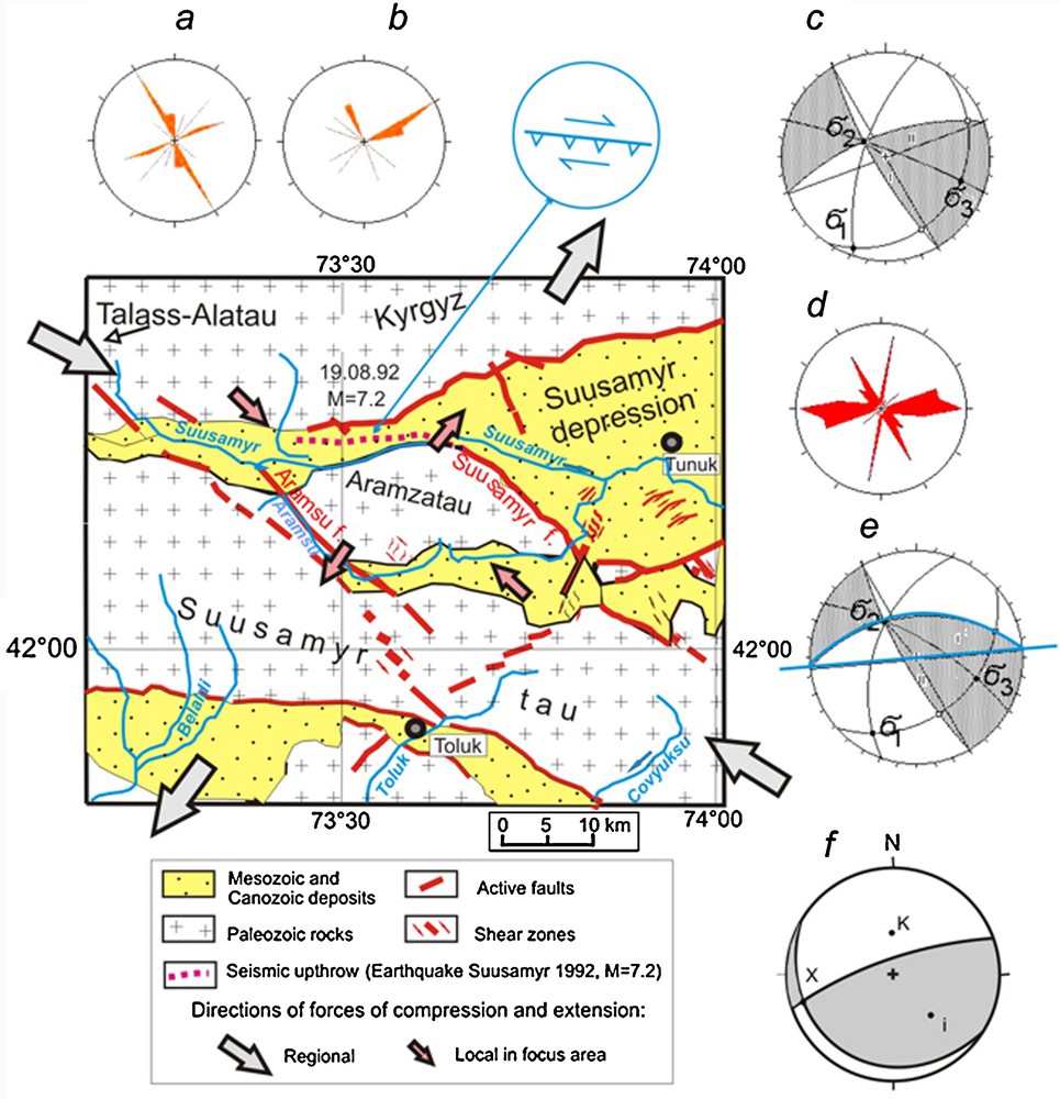
Tectonic sketch of the focal zone of the Suusamyr earthquake 19.08.1992, M = 7.2; a, b: strike and dip roses (a) of shear crack surfaces with slickensides (b) of Late Cenozoic displacements; c: orientation diagram of principal stress axes as derived from structural and kinematic data (building on the upper hemisphere): (σ1) – extension, (σ2) – intermediate, (σ3) – compression; d: strikes roses of seismic dislocations of the Suusamyr earthquake 1992 (M = 7.2), measured by the author; e: focal mechanism of Suusamyr earthquake from seismological data. Masquer
Tectonic sketch of the focal zone of the Suusamyr earthquake 19.08.1992, M = 7.2; a, b: strike and dip roses (a) of shear crack surfaces with slickensides (b) of Late Cenozoic displacements; c: orientation diagram of principal stress ... Lire la suite
Schéma tectonique de la zone focale du tremblement de terre de Suusamyr, 19.08.1992, M = 7,2 : a, b : rosaces de direction et de pendage (a) de surfaces de fractures de cisaillement avec stries, (b) de déplacements du Cénozoïque supérieur ; c : diagramme d’orientation des principaux axes de contrainte, tels qu’ils dérivent des données structurales et cinématiques (construction sur l’hémisphère supérieur) : σ1 – extension, (σ 2) – intermédiaire, (σ 3) – compression ; d : rosaces de directions des dislocations sismiques du tremblement de terre de Suusamyr de 1992 (M = 7,2), mesurées par l’auteur ; e : mécanisme au foyer du tremblement de terre de Suusamyr à partir des données sismiques. Masquer
Schéma tectonique de la zone focale du tremblement de terre de Suusamyr, 19.08.1992, M = 7,2 : a, b : rosaces de direction et de pendage (a) de surfaces de fractures de cisaillement avec stries, (b) de déplacements du Cénozoïque supérieur ; ... Lire la suite
The Suusamyr depression constitutes an elongated east-trending graben or syncline with a wide eastern part and a narrow western part. It is filled with Cenozoic deposits such as conglomerates, gritstones and clays interstratified with sandstones. According to Sadibakasov (1972), the total thickness of the Oligocene-Early Quaternary deposits reaches up to 1150 m. Elevation of the Suusamyr river-beds ranges from 2500–2600 m in the eastern part and 2800–2900 m in the western one. The Kirghiz and Talass-Alatau ridges are composed of magmatic, sedimentary and metamorphic rocks of Paleozoic age. Their maximum elevation reaches up to 4000 m. The contact between the ridges and the intervening depression is tectonic and constitutes a thrust type dislocation zone.
In the southern part of the Suusamyr depression, the Paleozoic formation of the Aramzatau and the Suusamyr ridges are thrust over Paleogene-Neogene formations (Fig. 2). The Aramzatau ridge is isolated and separated from the Suusamyrtau ridge by the intervening Aramsu depression. To the west the Aramzatau ridge and the Aramsu depression are under the control of the northwest-trending Aramsu fault zone (Fig. 2). The Aramsu fault zone has an ancient origin, which is clearly defined by an unconformity between formations of different ages. Modern tectonic activity is recorded by the deformations of river terraces, steps and scarps in the lanscape, and the presence of springs. The traces of paleo-earthquakes were also found. The Aramsu fault zone has great length and dissects the structure of the Talas-Alatau and Suusamyrtau area as a whole. To the south, along the Aramsu fault zone, Paleozoic rocks of Susamyrtau ridge are thrusted over the Neogene-Quaternary formations of the Toluk depression. Evidence of left-lateral slip movements was found along this fault.
Analysis of kinematic measurements on joints and other deformation features such as conjugated shear planes testifies to high structural and dynamic activity in these areas. The general distribution of various morpho-kinematic types of dislocations is as follows: thrusts (60%), normal faults (30%), and strike-slip faults (10%). Rose diagrams of the predominant thrust directions (NW-SE) and normal fault directions (NE-SW) are shown on Fig. 2a. Strike-slip faults are more commonly oriented in the NE-SW and the NW-SE directions (Fig. 2b). The data suggest a predominance of a NW-SE compression and a NE-SW extension. Using fault slip data, we have obtained the orientation of the principal normal stress axes of the focal zone of the Suusamyr earthquake (Fig. 2c). It is characterized by a subhorizontal north-west orientation of the relative compression stress axis (σ3)1, a subhorizontal north-east relative extension stress axis (σ1) and a subvertical intermediate stress axis (σ2). The stress field presents a combination of thrust and strike-slip types. It corresponds to an area of potential earthquakes. Interactions between the tectonic blocks of the Suusamyr and Aramzatau ridges and the intervening depression which separates them (Fig. 2) were responsible for the formation of the earthquake source. They are controlled by a WNW compression stress.
The characteristics of the primary seismic dislocations of the 19.08.1992 Suusamyr earthquake (Umurzakov, 1995) were studied. The rose diagram (Fig. 2d) reveals their predominance in orientation. The main trend corresponds to the plane of seismogenic rupture that came off to the surface (Fig. 2e).
The stress field obtained from the seismological data is shown in the diagram (Fig. 2e). It wholly coincides with the diagram (Fig. 2c) obtained according to structural observations and fault slip data set analysis. All these results derived from geological data are consistant with the characteristics of the focal mechanism derived from seismological data (Fig. 2f; Muraliev, 1993; Kuchai and Muraliev, 2000). It means that the focus of the Suusamyr earthquake was generated as a result of a NW compression stress within the limits of the Suusamyrtau ridge, the western part of the Suusamyr depression, and the Aramsu and Bel’aldy-Toluk depressions. Consequently, part of the crustal block of Aramzatau ridge was thrust over the Susamyr depression.
3 Structural architecture and geodynamics of the southwestern part of the Karzhantau (Chatkal – Kurama) mountainous region
The Azatbash (I) and Aktash (II) ridges are prominent features located near the southwestern extremity of the Karzhantau ridge, near its junction with the Kokpak (V) and the Chirchik (VI) depressions. In this area, the second order Karachatau (III) ridge is separated from the main Azatbash ridge (I) by the Azatbash depression (IV) (Fig. 3).

Tectonic sketch of the focal zone of the 1977 Tavaksay earthquake (M = 5.2). A. Rose of dip azimuths of shearing fractures. B. Diagram of orientation of Late Cenozoic main normal stress axes based on kinematic structural-geological data: (σ1) – extension, (σ2) – intermediate, (σ3) – compression. C. Focal mechanism of the earthquake from structural-geological data. D. Earthquake focal mechanism from seismological data (Bezrodny and Tuychiyev, 1987). E. Quaternary thrust near the Azatbash village, in the vicinity of the Karzhantau fault. See Fig. 2 for convention signs. Masquer
Tectonic sketch of the focal zone of the 1977 Tavaksay earthquake (M = 5.2). A. Rose of dip azimuths of shearing fractures. B. Diagram of orientation of Late Cenozoic main normal stress axes based on kinematic structural-geological data: (σ1) – extension, (σ2) – intermediate, (σ3) – compression. C. ... Lire la suite
Schéma tectonique de la zone focale du tremblement de terre de Tavaksay en 1977 (M = 5,2). A. Rosace des azimuths de profondeur des fractures cisaillantes ; B. Diagramme d’orientation des principaux axes de contrainte au Cénozoïque supérieur, basés sur les données cinématiques de géologie structurale : (σ1) – extension, (σ2) – intermédiaire, (σ3) – compression. C. Mécanisme au foyer du tremblement de terre à partir des données de géologie structurale. D. Mécanisme au foyer du tremblement de terre à partir des données sismologiques (Bezrodny et Tuychiyev, 1887). E. Charriage quaternaire près du village de Azatbash, au voisinage de la faille de Karzhantau. Voir Fig. 2 pour les signes conventionnels. Masquer
Schéma tectonique de la zone focale du tremblement de terre de Tavaksay en 1977 (M = 5,2). A. Rosace des azimuths de profondeur des fractures cisaillantes ; B. Diagramme d’orientation des principaux axes de contrainte au Cénozoïque supérieur, basés sur les données cinématiques ... Lire la suite
All these ridges are composed of Paleozoic rocks. In the southern flank of the Azatbash ridge, the Paleozoic strata are gently dipping towards the south but their dipping attitude is sharply changing near the Karzhantau fault zone. These Paleozoic series are thrust over red Cretaceous sandstones along the fault zone. The northward dip of the fault plane is about 60–70°. The fault zone at the junction with the Azatbash depression is defined by a narrow transition between an old Pre-Cretaceous erosional surface and a Middle- to Late-Quaternary erosional surface.
To the north-west of the Azatbash village the vertical amplitude of the overthrust reaches up to 10 m, and the visible fault line displacement is up to 16 m (Fig. 3E). The fault plane azimuth and dip are 310° and 35°, respectively. The deformations of the Q2 terrace surface to the south-west of the village of Aktash, in the Shurabsay-Soylik area, testify to the active tectonics. Landslides are common in the region as well as surface ruptures of submeridional strike with small (i.e., 0.5 m) left-lateral displacements.
The Kharzhantau fault zone is intersected by the Shurobsay fault zone, which has a submeridional strike-slip (Fig. 3). From the mouth of Shurobsay River upwards, the width of the intersection zone between the Karzhantau and the Shurobsay faults expands up to 2–3 km, accompanied by numerous dislocations such as separate ruptures, shatter zones, fractures, sometimes associated with landslides. The “Shurobsay” paleoseismic dislocation of downfall rocks was found here (Umurzakov, 1999). The morphology of this landslide is outlined by a thick series of loess-like-type Q2 formations, associated to a terrace surface which is truncated by the fault, with a vertical offset amounting to 15–20 m. Strike of the rupture plain is W260°. The normal fault surface has an azimuth of 360°, with a dip angle of 55°. About 100–300 m north of the main fault is observed a smaller rupture, which forms a secondary fault. The Shurobsay valley experienced a local landsliding, forming a cuplike trough whose contours are delineated locally by relatively fresh fractures and normal fault ruptures.
Almost all the river-beds of the SE slope of the Kurudzhaylau Mountain display a characteristic bend, indicating the presence of a shear zone. It is also shown by the offset of the Q2 surface of the slope of the Tavaksay ridge at an elevation of 1125 m, about 0.5 km south of the Kurudzhaylau Mountain culminating at 1495.5 m. One can observe a young rupture crosscutting the streams, small river valleys and water divides, and forming tectonic scraps along the fault zone. The valleys display a southward S-type bent. Based on these observations, we can identify a displacement zone, which could have been accompanied by seismogenic motions.
The young dislocations described above suggest that the Azatbash ridge keeps moving southward. The total magnitude of the strike-slip displacement for the late Eocene-Holocene period is inferred to be ca. 2 km (Umurzakov, 1999). The relative offset of the Aktash ridge with respect to the Azatbash ridge is assessed to amount to 700–800 m, and to 1–1.5 km with respect to the Karachatau ridge.
The detailed mapping which was carried out to study kinematic data shows that northwest-trending faults have left-lateral components of movements, whereas northeast-trending faults have right-lateral components of movements. The thrusts accounting for regional tectonic uplift have either a southwestern or a southeastern orientation (Fig. 3A).
The Fig. 3B diagram shows the regional stress field, which was inferred from structural and geological data. It corresponds to the latest Quaternary one. The activity and wide range of movements and deformations started in the Quaternary period. It is indicated by the offset of deformation structures and active thrusts near the termination and in the southeastern part of the ridges. The local stress field (Fig. 3C) reconstructed from field data has the same characteristics as the regional one (Fig. 3B).
The reconstructed stress field is in agreement with the focal mechanism data of the 1977 Tavaksay earthquake (M = 5.0) (Bezrodny and Tuychiyev, 1987). The diagram of Fig. 3D displays the regional stress field reconstructed from structural and geological data, and is representative of the real dynamic conditions at the southwestern termination of the Karzhantau ridge.
The Tavaksai earthquake source relates to a dynamic environment induced by the superposition of various crustal blocks motion and deformation. This includes thrust and strike-slip motion along the Karzhantau fault zone, as well as a left-lateral displacement across the Shurabsai zone producing a southwards protrusion of the Azatbash-Karachatau ridges toward the Chirchik depression.
4 Structural architecture and geodynamics of the Gissar area and its southwestern spurs, epicentral zone of the Karatag earthquakes
Another seismically active region in the southern Tien-Shan region consists of the Gissar mountainous system and its southwestern spurs. A description of the southern slope of the Gissar ridge near its southwestward virgation is presented in Figs. 1 and 4. Numerous genetic types of tectonic movements and deformations can be observed in the Gissar area: on the one hand, some deformations occurred under the influence of the direct compressive stress from the Pamir–Hindu Kush region, whereas others occurred under the influence of local deep thermodynamic processes accompanied by phase transformations and metamorphism, the presence of elastic and plastic deformations taking place both vertically and laterally at the transitions with magmatic intrusions.
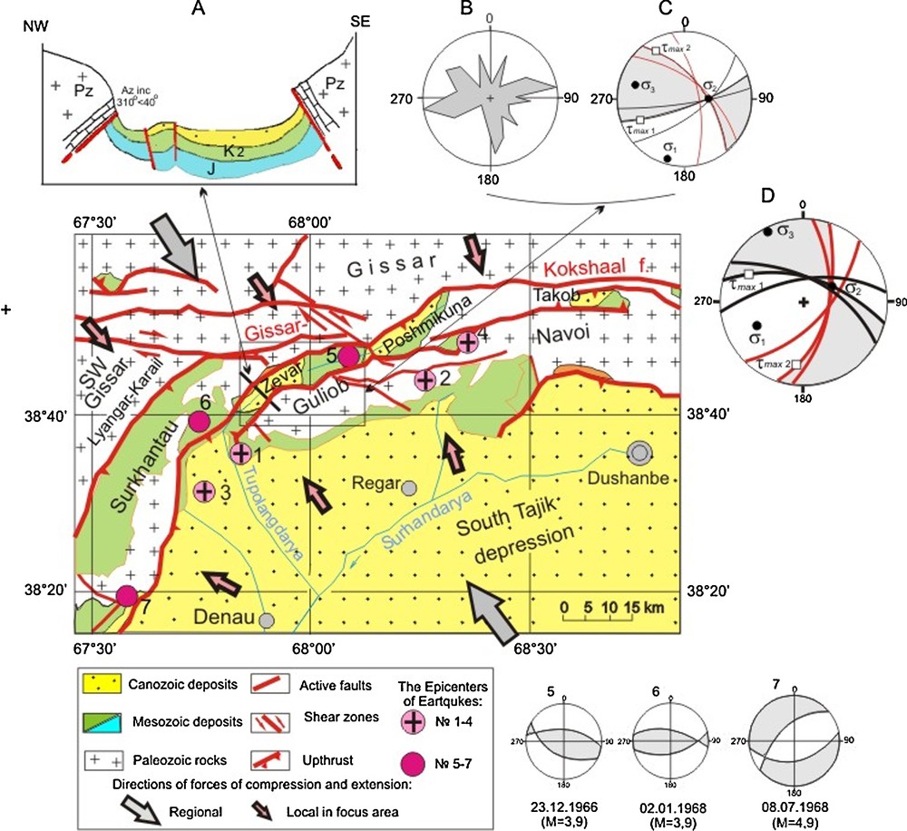
Tectonic sketch of focal zone of the1907 Karatag earthquakes (M = 7, 0–7.5). A. Schematic section of the Zevar depression. B, C. Strike rose (B) of Late Cenozoic joints and fractures and the stress field (C) in the Zevar section. D. Regional stress field inferred from structural and geological data; the numbers on the map correspond to the earthquake epicenters: 1, 2, 3 – Karatag 21.10.1907 (M 7.5; 7.3; 7.0), 4 – Chuyanchin 27.10.1907 (M = 6.2), 5 – 23.12.1966 (M = 3.9), 6 – 02.01.1968 (M = 3.9), 7 – 08.07.1968 (M = 4.9).
Schéma tectonique de la zone focale des tremblements de terre de Karatag (M = 7,0–7,5). A. Coupe schématique de la dépression de Zevar. B, C. Rosace de direction (B) des joints et fractures du Cénozoïque supérieur et champ de contrainte (C) dans la zone de Zevar. D. Champ de contrainte régional déduit des données structurales et géologiques ; les chiffres sur la carte correspondent aux épicentres du tremblement de terre : 1, 2, 3 – Karatag 21.10.1907 (M = 7,5 ; 7,3 ; 7,0), 4 – Chuyanchin 27.10.1907 (M = 6,2), 5 – 23.12.1966 (M = 3,9), 6 – 02.01.1968 (M = 3,9), 7 – 08.07.1968 (M = 4,9). Masquer
Schéma tectonique de la zone focale des tremblements de terre de Karatag (M = 7,0–7,5). A. Coupe schématique de la dépression de Zevar. B, C. Rosace de direction (B) des joints et fractures du Cénozoïque supérieur et champ de contrainte (C) dans ... Lire la suite
The superimposition of two systems of structural elements, i.e., a northwestern one and northeastern one, is clearly defined. The former one was active along old pre-Mesozoic structures, whereas the latter one corresponds to an Alpine episode of deformation. The overall structure of this region is made up of a huge number of structural elements with distinct orientations, as indicated by field data and geological maps.
Local Mesozoic-Cenozoic depressions occur between uplifted compressional structures, e.g., the Zevar depression and the Aksu Valley (Fig. 4A). The uplifted domains are composed of large morphological ridges. The size of the youngest ridges is comprised between 4–5 km, up to 6–7 km.
The eastern boundary of the Zevar depression is represented by upthrows of Carboniferous limestones (Fig. 4A), Cretaceous gravelstones and Jurassic sandstones. This fault zone is traced along the Kaflangdarra stream, bending eastward along the Obichnargas valley head. The fault zone accounts for numerous steps in the relief, but sometimes it accounts for a narrow or a wide trench. The western wall of the fault zone is composed of Mesozoic rocks, the azimuth of the beds amounts to 300° with dips of 65° north of Kaflangdarra, whereas the azimuth of the beds amounts to 230° with dips of 70° south of Obichnargasa. A series of young active dislocations are observed in the middle watercourse of Tupolang River and its tributaries, i.e. the Maulyandary, Zanghana, Obichnargas and Kaflangdarra rivers. West- and northwest-trending fractures can be found along this segment (Fig. 4B).
Along the left bank of the Tupolangdarya River, southwest of the Zevar depression, the Middle-Quaternary erosional surface is weakly deformed and dislocated by small ruptures. The regional extent of the fault zone is not only evidenced through the dislocation of Paleocene limestones in the southeastern part of the Chakmangarlyen area, at the mouth of the Burcialosay valley, but also by a step in the relief of the Quaternary terrace. The fault zone displays an en-echelon pattern and is turning eastward. Downstream in the Tupolang valley, the terrace surfaces are dislocated and uplifted by recent ruptures. The relief rises up southeastward, although the size of the valley tends to decrease. These observations are indicative of active tectonics during the Quaternary period. The stress field inferred for this section is shown in the diagram C (Fig. 4).
Our data outline the deformation pattern of the main tectonic blocks in the study region, i.e. the Surkhantau-Gissar blocks in the north and the Guliob-Navoi blocks in the south (Umurzakov, 2007). Such zonality is shown both by the geological data and by the geomorphology. The data set indicates a modern block activity, which is confirmed by the occurrence of strong earthquakes, including old ones. The earthquake focal mechanisms are mostly located near the borders of large tectonic blocks, which are also the regions recording various deformation mechanisms.
We have evidenced that the stress field, which is peculiar to the zone of arched tectonic blocks, is characterized by a NW-SE orientation of the relative compression axis (Fig. 4D).
A stress field characterized by a strike of the main compression axis parallel to the main structures was observed in the southwestern spurs of Gissar ridge, e.g. the Zevar-Tupolang block and the Lyangar-Karail ridge. The relative extension axes remain stable and subvertical even when the main compression axis changes from a sublatitudinal trend in the northern part of the area, to a northeastern direction in the eastern ridge, or to the northwest trend in the western block. Such a stress field relates to the lateral motion and the counterclockwise rotation of tectonic blocks of the southwestern spurs of the Gissar ridge along the deep Gissar-Kokshaal fault zone. The Gissar block is considered as the most uplifted one with the largest crustal thickness. It most likely resulted from the formation of northwest-trending thrusts and left-lateral displacement of rupture structures under conditions of the inferred stress field within the limits of the Gissar region. Similar arched structural elements are also found in the Gissar area, i.e., the Surkhantau-Gissar ridges, and southward, in the Guliob-Navoi ridge. The narrow Zevar-Poshmikuna-Takob depression is located beween these ridges. Most of the local Mesozoic-Cenozoic depressions of the southern slopes of the Gissar ridge join in this narrow zone. The Karatag earthquake focal mechanism results from stress accumulations and releases in the zone of junction and dynamic interaction among various crustal blocks. The earthquake foci are confined to this zone: Baysun (08.07.1968. M = 4.7), Karatag series (21.10.1907, M = 7.5, M = 7.3, M = 7.0), Chuyanchin (27.10.1907, M = 6.2). Their focal mechanisms correspond to the inferred stress field. Only small and comparatively shallow foci of the 1966 (M = 3.9) and 1968 (M = 3.9) earthquakes are located in the depression itself (Fig. 4, epicenter numbers 5 and 6).
5 Conclusions
Our results allow us to draw the following important conclusions:
- • the regional stress field that we could derive from field and seismological data practically coincides with the stress field described in previous studies. At a closer look, however, some regions of the western Tien-Shan display different distributions of the principal axe directions. A nearly north-south compression is observed only in the Chatcal-Kurama and Turkestan–Zarafshan regions. In some sectors within the study area, the compression axis slightly deviates from its original direction. It deviates from a nearly north-south orientation in the eastern part of the study area to the NW in its western and southern portions;
- • within the western Tien-Shan, the focal mechanisms of the largest earthquakes are usually associated with the oblique slip faulting and disruption of large tectonic blocks caused by the Late Cenozoic geotectonic processes;
- • a good match was obtained between the present day stress field reconstructed from the focal mechanism data, and the recent stress field derived from microtectonic studies. This may be helpful in the prompt identification of future earthquake source mechanisms.
1 The indication of compression axis (σ3) and of tension axis (σ1) for former USSR countries uses opposite symbols compared to European ones.