

1 Introduction
According to Trompette (1973) and Deynoux (1980), the lithostratigraphy of the West African craton consists of a metamorphic basement capped by several sedimentary covers. These covers include three main groups separated by two erosional unconformities both underlined by glacial sediments. The two glacial levels have been respectively ascribed to the cryogenian “Marinhoan” event (635 Ma) and to the Uppermost Ordovician (Hirnantian) glacial event.
The lower “super group 1” (SG1) contains marine and continental Neoproterozoic sediments and the middle “super group 2” (SG2, Late Neoproterozoic to Late Ordovician) begins by three associated levels called the “Triade”. The Upper “super group 3” (SG3, Late Ordovician to end of Devonian) begins by a “Hirnantian” tillite. This simplified lithostratigraphic succession has been used for correlations all over the West African countries, even in the deformed and locally metamorphosed surrounding belts.
However, Villeneuve (1982, 1984) evidenced, in northern Guinea, a regional unconformity between a lower volcano-sedimentary sequence (strongly deformed) and a slightly deformed upper sedimentary sequence beginning by a brecciated level, locally including glaciogenic material. This regional unconformity, called the “Koubia–Lessere unconformity” (KLU), was first evidenced in the Lessere area and then supposed in the Kankata area by Brinckmann and Meinhold (2007). According to the Taoudeni lithostratigaphic chart (Trompette, 1973), the upper sequence was correlated with the “super group 2” (SG2) and the lower sequence to the “super group 1” (SG1). Because the super group 2 glacial basal level was correlated with the worldwide “Marinhoan” glacial event, breccias underlying the KLU were also recorded to this Marinhoan glacial event. However, sedimentary glacial levels were also evidenced in the Bassaride belt (Bassot, 1966; Villeneuve, 1984), and consequently this Bassaride glacial sediments were linked to the more ancient worldwide “Sturtian” (750–700 Ma) glacial event (Villeneuve, 2006). This interpretation was supported by the metamorphic ages (circa 650 Ma) recorded in the Bassaride Guinguan group (Dallmeyer and Villeneuve, 1987). These interpretations (Table 1) have lasted until 2008 (Villeneuve, 2008) despite a large deficit of radiometric data.
Geological scheme of the West African area according to previous works.
| Periods | Belts | Southern basins | Taoudeni basin |
| Ordovician to Devonian (488 to 355 Ma) | Mauritanide belt | Bové basin | Super groups 3 and 4 |
| Cambrian to Ordovician (520 to 490 Ma) | Mauritanide belt | Youkounkoun group | Super groups 2 and 3 |
| Late Proterozoic to Cambrian (635 to 520 Ma) | Rokelide belt (Panafrican-II) | Mali group | Super group 2 |
| Cryogenian (850 to 650 Ma) | Bassaride belt (Panafrican-I) | Madina–Kouta group | Super group 1 |
| Tonian (1000 to 850 Ma) | ????????????? | Segou group | Super group 1 |
| Birrimian to Archean basement (3 to 2.5 Ga) | Leo Uplift basement | Leo Uplift basement | Leo uplift and Reguibat basement |
Since 2007, several cartographic projects accompanied by a lot of new radiometric dating measurements were performed in northern Guinea (Brinckmann and Meinhold, 2007), Senegal (Buscail et al., 2010, Fullgraf et al., 2010, Lahondère et al., 2010) and southern Guinea (Bering et al., 1998). These new radiometric data allow us to reassess the lithostratigraphic position of the “Koubia–Lessere unconformity” and consequently to change drastically the previous geological framework.
2 Geological setting
The West African basins (Taoudeni, Tindouf, Madina–Kouta, Gourma, Ougarta, etc.) and belts (Mauritanides, Rokelides, Trans-Saharan belt, Anti-Atlas belt, etc.) were always studied separately. Eastern Senegal and western Guinea were studied during the early twentieth century (De Chetelat, 1933; Renaud and Delaire, 1955), but a coherent scheme including the whole western margin was delivered after 1960. Sougy (1962) yielded the first global interpretation and distinguish two belts: a northern belt (Mauritanides) running from the “Spanish Sahara” to the northern Guinea Bissau and involving the northern part of the Palaeozoic Bové basin (including the Devonian deposits) and a southern belt (Rokelide) unconformably covered by this Palaeozoic Bové basin. So, the first belt was linked to a “Hercynian” orogen and the second one to a “Caledonian” orogen. Bassot (1966, 1969) confirmed this interpretation in southeastern Senegal and northern Guinea.
Then, the Soviet-Guinean cartographic program (1968–1975) performed several 1/200,000 geological maps in western Guinea, including the “Bassaride” belt area (Petrovsky et al., 1973). However, Villeneuve (1980, 1984) evidenced a regional unconformity: the KLU (Koubia–Lessere Unconformity) between the underlying metamorphic Bassaride formations and the overlying sedimentary covers beginning by a mixed molassic and “glaciogenic” level. Dallmeyer and Villeneuve (1987) dated the metamorphism at circa 650 Ma and consequently linked this metamorphic formations to the “Panafrican-I orogen”. To the south, the Rokelide belt (Allen, 1969; Culver and Williams, 1979) experienced a metamorphism event dated at circa 550 Ma linked to the Panafrican-II orogen (Villeneuve and Dallmeyer, 1987).
From 1998 to 2007, a “German–Guinean” cartographic team (PAGEM 2) worked on the Guinean Bassaride area (Brinckmann and Meinhold, 2007). But the last investigations in the Bassaride area took place with the cartographic “PASMI” project (2009–2010) in eastern Senegal (Fullgraf et al., 2013). These two cartographic projects provide numerous radiometric data that turn down the Villeneuve and Dallmeyer (1987) interpretation and lead us to rework this “Koubia–Lessere” unconformity in order to re-evaluate its extension, age, and geological significance.
3 The Koubia–Lessere unconformity (KLU)
The KLU is evidenced in three different areas: the Bassaride ranges, the Kemberra inlier and the Tominé inlier. All are located in Fig. 1a.

(Color online.) Geological sketch map of the Bassaride area: a: location of the Bassaride area, Kemberra and Tominé inliers, according to Villeneuve (1984). 1 – Birrimian, 2 – Madina–Kouta group, 3 – Guinguan group, 4 – Termesse, Nandoumba and Walidiala groups, 5 – Niokolo–Koba and Panampou groups, 6 – Mali group, 7 – Youkounkoun and Boundou groups, 8 – Pita group (Bové basin), 9 – Koulountou group; b: geological sketch map of the Bassaride area. Pt gr = Pita group (Bové basin), Yk gr = Youkounkoun group, Ml gr = Mali group, Bd.gr = Boundou group, Ndb gr = Nandoumba group, Gui gr = Guinguan group, Kb cpx- Koubia volcanic complex, Tms/wd gr = Termesse and Walidiala groups, SMk gr = Ségou-Madina–Kouta group, Bs = Birrimian basement. Empty triangles on line = Main thrust supposed (dashed lines) and occurrences (plain lines), 650 = radiometric age in million years, black triangles = Toulel Sigon mixtite, empty triangles = Walidiala tillite, + = radiometric age by U/Pb on zircons, black star = radiometric age by 39Ar/40Ar on mineral. BFT = Bassaride Front Thrust, YKF = Youkounkoun/Kifaya Fault, Bgr = Bangare, Slm = Salemata, Tky = Tiankoye, Souk = Soukouta, Na = Namel, Nb = Ndebou, Bdf = Bandafassi, Kd = Kedougou, Wl = Walidiala, Lbk = Lebekere, Tb = Touba, Ls = Lessere, Kb = Koubia, Tms = Termesse, Gui = Guinguan, KFy = Kifaya, Lpk = Lampoukene, Mw = Mowomba, ML = Mali, Wr = Warnani, Ybr = Yambering, Ds = Dongol Sigon, Ts = Toulel Sigon, Pl = Pilimini, Kmb = Koumbia, Bl = Bantala, NL = Niela, HP = Hore Pete, Kst = Kounsitel, Gl = Gaoual. Solid line: 1, 2, 3, 4, 5 = location of cross-sections in Fig. 2.
3.1 In the Bassaride area
Fig. 1b shows the geological scheme performed by compilation of the Villeneuve (1984), Brinckmann and Meinhold (2007) and Fullgraf et al. (2010) surveys. The upper “Mali” group is overlying both the Madina–Kouta group (to the east) and the Bassaride groups. The Bassaride belt includes five different groups and complexes, among which the Termesse group that overlies the Madina–Kouta basin, in Walidiala. Two windows are evidenced in the “Mali” group, in which occurrences of the Termesse group are suspected.
The five main cross-sections located in Fig. 1b and shown in Fig. 2 allow us to present the “Koubia–Lessere” unconformity in the eastern side of the Bassaride belt with, from the north to the south: the “Nepin Peuhl” cross-section (1 in Fig. 2) showing deformed shales with isolated clasts to the base and a flat “Bouma” sequence to the top, the Termesse–Lessere cross-section (2 in Fig. 2), where the “Koubia–Lessere” unconformity was first evidenced, the “Lampoukenn–Kouragnaki” cross-section (3 in Fig. 2) interpreted from the geological map and showing an unconformable contact between the underlying “Termesse group” and the overlying “Mali group”, the “Hamdallaye–Bantala” cross-section (4 in Fig. 2), which is based on a free interpretation of the Brinckmann and Meinhold (2007) geological map and, finally, the Kounsitel–Hore Pete cross-section (5 in Fig. 2), which is a re-interpretation of the eastern part of a Brinckmann and Meinhold (2007) cross-section and displays a structural discrepancy between the folded underlying “Termesse group” and the flat overlying “Mali Group”.
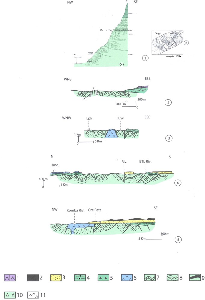
(Color online.) Cross-sections in the eastern Bassaris range. Evidence for the KLU (Koubia–Lessere Unconformity). 1 – a: Nepin Peulh cross-section (Villeneuve, 1984); b: details of folds. 2 – Termesse–Lessere cross-section (after Villeneuve, 1984 modified). 3 – Lampoukene–Bangui cross-section (Lpk = Lampoukene, Krw = Kouravelwol river). 4 – Hamdallaye–Bantala cross-section (Hmd = Hamdallaye, Btl Riv. = Bantalawol river). 5 – Komba–Sabere cross-section (Komba Riv = Komba River). 1 – dolerite, 2 – Telimele group, 3 – Pita group, 4 – Mali group, 5 – Toulel Sigon mixtite, 6 – Koubia volcanism, 7 – limestones of the Termesse group, 8 – shales of the Termesse group, 9 – Termesse group volcanism, 10 – mixtite of the Termesse group (Walidiala mixtite), 11 – dolerite sills.
For us, all these cross-sections underline an unconformity between the lower deformed and slightly metamorphosed “Termesse” (or Panampou) group and the overlying “Mali” group. But the conglomeratic (or tillitic) levels at the base of the Mali Group are very scarce.
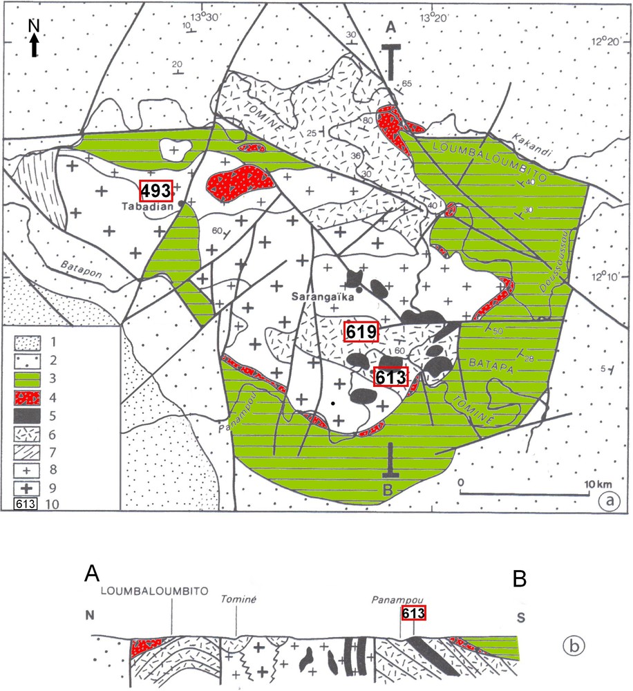
3.2 In the Kemberra inlier
The “Kemberra Inlier” is located 30 km to the south-west of Gaoual (Fig. 3a). It was investigated by Villeneuve (1979). In the southern part (Fig. 3b), this inlier shows several formations below the flat Pita group sandstones. There is a granitic basement similar to the Niokolo–Koba one (of the Bassaride areas). This granitic basement is associated with a metasedimentary succession (Tagirata formation) including breccias, sandstones and volcanic metatuffs exhibiting a sericitic schistosity and stratigraphic layers with dips between 60 to 80° to the east (Fig. 3c). On the western side, the granitic basement is capped by a set of mylonitic and blastomylonitic metatuffs. Along the Netivel stream, a palaeovalley dug in the Tagirata sandstones is infilled with breccias linked to the “Illiassa polymict breccias” outcropping at the base of the Mali group. On the eastern side, the Mali group beginning by the “Illiassa polymict breccias” and overridden by argilites and siltites shows a 30 to 40° dip to the east below the horizontal Pita group. The KLU is located on top of the “Tagirata sandstones” and at the base of the “Illiassa polymict breccias”.

The Kemberra inlier (adapted from Villeneuve, 1979): a: location of the Kemberra inlier in the Bassaride area. 1 – Granitic basement, 2 – Guinguan group, 3 – Termesse group, 4 – Mali group, 5 – Youkounkoun group, 6 – Pita group; b: geological sketch map of the Kemberra inlier. 1 – Modern alluvions, 2 – Lateritic bowal, 3 – Pita sandstones, 4 – Mali shales, 5 – Illiassa polymict breccias, 6 – Tagirata breccias, 7 – Tagirata sandstones, 8 – Mylonitic tuffs, 9 – Granitic basement, 10 – Granitic intrusions, 632 = Altitude in metres; c: AB geological cross-section. 1 – Granitic basement, 2 – Tagirata sandstones, 3 – Mylonitic tuffs and volcanic tuffs, 4 – Illiassa breccias, 5 – Mali shales, 6 – Sandstones of the Pita group.
3.3 In the Tominé inlier
The “Tominé inlier” surrounded by the Youkounkoun sandstones, crops out in the centre of the Youkounkoun basin (Fig. 4). It was successively investigated by Torchine (1976), Villeneuve (1984) and Brinckmann and Meinhold (2007). It consists (Fig. 4a) of a basement made of granitoid rocks intruded by rhyolitic and dacitic dykes belonging to the “Panampou group”. This “Panampou Group” is linked to the Niokolo–Koba volcanic arc. This volcanic arc is intruded by a microgabbro patch outcropping north of Tabadian. This basement is unconformably overlain by the “Lumbalumbito” conglomerate (partly of glacial origin) and by the “Batapa” argilites that are linked to the Mali group (Fig. 4b). The KLU separates the basement from the Lumbalumbito conglomerate.
(Color online.) The Tomine inlier (Adapted from Villeneuve, 1984). a: Geological sketch map of the Tominé inlier. 1 – Sandstones of the Pita group, 2 – Youkounkoun group, 3 – Mali group, 4 – Lumbaloumbito conglomerates (mixtites?), 5 – Rhyolites, 6 – Volcano-sedimentary deposits of the Panampou group, 7 – Batapon quartzites, 8 – Granodiorites and microgabbros, 9 – Granitic basement, 10 – Radiometric dating (610 = in million years, U/Pb on zircons). b: North–south geological cross-section. Legend: idem a.
4 Previous geochronological data
The first radiometric data came in the 1960s, first in Senegal (Bassot et al., 1963) and, later on, in Sierra Leone (Allen, 1969; Allen et al., 1967), and in Mauritania (Lille, 1967).
Rb/Sr radiometric dating on red argilites evidenced an age at circa 1022 ± 20 Ma on argilitic rocks sampled at the base of the Madina–Kouta group and a Panafrican age (645 ± 39 Ma) on biotites extracted from a grano-dioritic sample belonging to the Niokolo–Koba magmatic complex (Bassot et al., 1963). They also evidenced a Late Precambrian age (560 ± 50 Ma on argilitic fraction) from pelitic rock of the Youkounkoun group and several Hercynian metamorphic events (358 ± 33 and 206 ± 6 Ma) in northeastern Senegal (Bakel group). Later on, Bassot and Caen-Vachette (1983) indicated a 683 ± 18 Ma age (isochron on whole rock) for the “Niokolo–Koba” protolith.
Then, Dallmeyer and Villeneuve (1987) provided thirteen 39Ar/40Ar radiometric ages from southern Senegal, among which three 40Ar/39Ar radiometric ages on muscovites extracted from the Guinguan group quartzites.
Later on, Brinckmann and Meinhold (2007) provided new radiometric data from northern Guinea: 15 U/Pb on zircons (6 on the Bassaride ranges), six Rb/Sr (five on the Bassaride ranges) and one Ar39/Ar40, also on the Bassaride ranges. Moreover, 10 new U/Pb age data on zircons (three in the Niokolo–Koba area and seven in the Bassaris range) were obtained by the “PASMI” cartographic project in Senegal (Fullgraf et al., 2010).
4.1 In the Bassaride area
Ages (by 40Ar/39Ar method) in the Bassaride belt delivered by muscovites from quartzophyllitic rocks allowed Dallmeyer and Villeneuve (1987) to ascribe this metamorphism to a Panafrican event (called the Panafrican-I) that occurred between 666 and 656 Ma. These radiometric data allowed them to distinguish a Bassaride Panafrican event (Panafrican-I, 650 Ma) from a Rokelide event (Panafrican-II, 540 Ma).
According to Brinckmann and Meinhold (2007), ages (U/Pb on primary zircons) taken from intrusive rocks indicate a Panafrican-II orogen (650–540 Ma), but one of them (from the Nandoumba basalts) indicates a Late Cambrian intrusion (494 ± 5.2 Ma). In addition, detrital zircons from the Bassaride quartzites display several Kibarian ages (between 1765 and 1298 Ma). Moreover, new age data on zircons provided by the “PASMI” cartographic project in Senegal (Fullgraf et al., 2010) favoured a Panafrican-II (650–550 Ma) volcanic arc in the Niokolo–Koba area and a Panafrican-II volcano-sedimentary back arc-basin in the Bassaris area. However, the “Pasmi project” evidenced younger volcanic intrusions in the Bassaride area (428 and 396 Ma), also deformed. This suggests that one or several Palaeozoic magmatic events occurred in the Bassaris range of Senegal.
4.2 In the Kemberra inlier
No age data have been published in this inlier, but according to Mueller (pers. com) the youngest detritic zircons included in the Tagirata sandstones yielded a 531 ± Ma age. Consequently, the “Illiasa breccias” and the overlying pelites should be younger than 531 Ma. However, there are some age data concerning the surrounding ones. Two are relative to the “Télimélé” inlier, which is located 60 km to the south, and another one concerns the “Yoli Monza” inlier, located only five kilometres to the north-east. Ages obtained on muscovites from the Télimélé inlier mylonites are respectively: 745 ± 20 Ma (Rb/Sr) and 525 ± 10 Ma (Ar/K) according to Seliverstov (1970). The youngest zircon age recorded in the Yoli Monza inlier is 625 ± 1 Ma (U/Pb on zircons extracted from a tonalitic sample) according to Brinckmann and Meinhold (2007).
4.3 In the Tominé inlier
Magmatic intrusions have been dated by Brinckmann and Meinhold (2007). Zircons from these intrusions display several U/Pb ages ranging from 493 Ma to 665 Ma, with a mean age around 620 Ma. The youngest zircons are provided by the “Tabadian” microgabbro (493.3 ± 8 Ma). The “Panampou” rhyolites and leucogabbro close to the Sarangaïka village (eastern part) provided primary zircons that displayed several ages around 621 ± 2 Ma. According to these results, the overlying “Lumbalumbito” breccias at the base of the Batapa (or Mali) argilites are younger than 620 Ma and, according to the Tabadian microgabbro, they are younger than 493 Ma.
5 Discussion and interpretation
New radiometric data from Senegal and Guinea suggest a volcano-sedimentary basin in the Bassaride area that operated between 700 Ma and 494 Ma, involving the lower Bassaride groups (Termesse, Guinguan, Panampou, Nandoumba). These groups experienced the same Panafrican-II orogenic event and, consequently, they belong to the Panafrican-II (Cadomian) orogen, which includes the Panafrican-I metamorphic event (Villeneuve and Dallmeyer, 1987). On another hand, the “KLU” separating these lower Bassaride groups from the overlaying “Mali” group is younger than 494 ± 5.2 Ma (age of the Nandoumba basaltic flows) and 493.3 ± 8 Ma (age of the Tabadian microgabbro). Consequently, the “Mali” group is younger than the Panafrican-II orogen and has likely been deposited after 493 Ma. This hypothesis is illustrated in Fig. 5, where the previous (Villeneuve, 1980) interpreted cross-section (Fig. 5b) located in Fig. 5a is now completed (Fig. 5c) noticeably between the Bassaride ranges and the Madina–Kouta basin areas. In this cross-section, the “Mali” group is capping the Madina–Kouta basin, the Bassaride belt, and the Niokolo–Koba volcanic arc. However, the “Mali” group is deformed only in the Bassaris range and in the Niokolo–Koba volcanic arc. These deformations are related to a Late Cambrian or Early Ordovician tectonic event. The overlying and flat “Youkounkoun group” could represent the “molassic” stage associated with this tectonic event. Thus, the KLU should be differentiated from the Walidiala erosional unconformity (WU) that separates the Madina–Kouta formations correlated with the Super Group 1 (SG1) of the Taoudeni basin from the “Triade” ascribed to the worldwide “Marinhoan” glacial event (635 Ma).
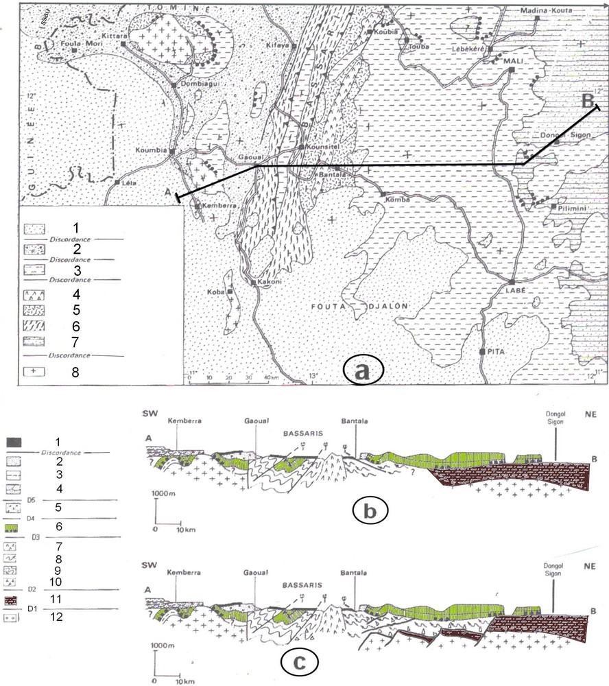
(Color online.) Geological interpretation of the northern part of the Fouta Djalon massif (location in Fig. 7); a: geological sketch map of the northern Fouta Djalon with location of the cross-section A–B, according to Villeneuve (1980). 1 – Pita, Telimélé and Faro groups, 2 – Youkounkoun group, 3 – Mali group, 4 – Koubia complex, 5 – Termesse group, 6 – Guinguan group, 7 – Madina–Kouta group, 8 – Birrimian Basement; b: interpretative cross-section from Kemberra to Dongol Sigon, according to Villeneuve (1980). 1 – Lateritic bowal, 2 – Faro group, 3 – Telimélé group, 4 – Pita group, 5 – Youkounkoun group, 6 – Mali group, 7 – Koubia complex, 8 – Termesse group, 9 – Guinguan group, 10 – Walidiala tillite, 11 – Madina–Kouta group, 12 – Birrimian basement; c: new interpretation of the same cross-section. Legend: idem b.
Our new hypothesis consisting in rejuvenation (from 635 to 490 Ma) of the KLU previously correlated with the Walidiala Unconformity. So, there are two diachronous unconformities, each one overlain by conglomeratic levels bearing evidences of a “glaciogenic” environment. That allows us to propose new correlations inducing several geological modifications on the western margin of the West African Craton.
6 Correlations
Until now, the geological correlations across the West African craton were supported by a fundamental “stratigraphic” postulate coming from the Mauritanian Atar lithostratigraphic succession used as a referential scale for the whole West African area (Trompette, 1973). This lithostratigraphic chart took into account only one Precambrian/Cambrian glacial event (the Jbeliat tillite). Thus, all “tillitic” or “mixtitic” sediments deposited in West Africa in this time bracket were then linked to this event, itself correlated with the worldwide “Marinhoan” glacial event (650–635 Ma). Despite some local attempt to shake this rule, no consistent arguments prevent this postulate. The last synthetic paper devoted to the West African glacial events (Deynoux et al., 2006) validated the “triade” as a Marinhoan glacial deposit. Since this time, every geologist working in West Africa has to be in accordance with this stratigraphic scale.
Here, we are changing this rule by proposing another kind of correlation. We admit two regional unconformities underlined by two different conglomeratic levels with “tillitic” or “conglomeratic” evidences. The older one (Walidiala tillite) located at the base of the lower Bassaris Groups (Termesse or Faleme groups) is correlated with the “Marinhoan” glacial event (Shields et al., 2007) and the younger one (Toulel Sigon conglomerate) located at the base of the “Mali” group is not yet correlated with a worldwide event. Sometimes this conglomerate presents glacial characters and sometimes there is a non-typical glaciogenic conglomerate and sometimes there is no clastic sediment at all. However, several indices of glacial occurrences in the Ediacaran to Cambrian times were evidenced in several West African places like in the Anti-Atlas (Vernhet et al., 2012), in the NE Taoudeni basin (Bertrand-Sarfati et al., 1995), in the Tanezrouft (Caby and Fabre, 1981), and in the Tamale group of the Volta basin (Affaton, 1987). The Toulel Sigon conglomerate may be coeval with one of them.
Fig. 6 illustrates the new correlations between the Bassaris area and the Adrar of Mauritania. In this figure:
- • the “Termesse” group is correlated with the “Teniagouri” group and the “Walidiala” tillite is correlated with the “Jbeliats” tillite of northern Mauritania;
- • the “Mali” group is correlated with the “Atar cliff” group and the “Youkounkoun” group to the lower part of the “Oujeft” plateau group;
- • the Pita group (base of the Bové basin) is correlated with the Oued Touergua group.
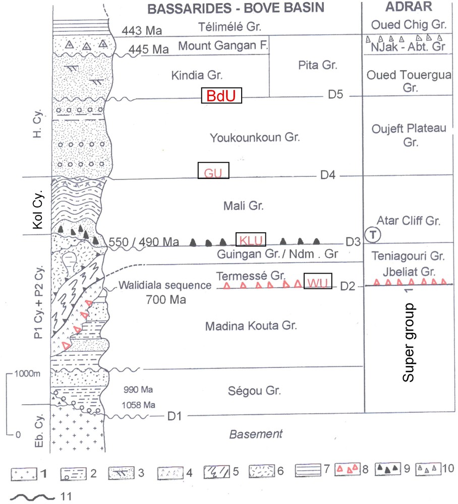
(Color online.) Lithostratigraphic succession in northern Guinea and correlations with the Adrar of Mauritania (modified from Deynoux et al., 2006). Eb.Cy = Eburnean cycle, P1 + P2.Cy = Panafrican 2 cycle (or Cadomian), Kol.Cy = Kolente cycle (Sarde tectonic event?), H.Cy = Hercynian cycle. 1 – Eburnean (or Birrimian) basement, 2 – shales and siltstones, 3 – sandstones, 4 – volcano-sedimentary rocks, 5 – phylladic rocks and micaschists, 6 – andesites, jaspers and rhyolites, 7 – siltstones and shales, 8 – “Walidiala” tillite (Marinoan glacial event), 9 – “Toulel Sigon” mixtite (Late Cambrian or Early Ordovician glacial event?), 10 – “Njakane–Abteilli” tillite (Late Ordovician glacial event), 11 – unconformity. WU = Walidiala unconformity (D2), KLU = Koubia–Lessere unconformity (D3), GU = Gaoual unconformity (D4), Bd.U = Bandiagara unconformity (D5). Gr = group. Njak–Abt .gr = Njakane–Abteilli group. F = formation, 440 Ma = age in million years.
Thus, these stratigraphic changes have fundamental consequences on the geological map (Fig. 7). For example, the southern “Rokel River” formations of Sierra Leone should be correlated with the “Mali” group, but not with the “Faleme” (or Termesse) group and the “tillitic” glacial levels setting at the base of this “Rokel River”group (Tabe formation) should be correlated with the “Toulel Sigon” conglomerate, but not with the “Walidiala” tillite. Consequently, the Rokelide basement of southern Guinea and Sierra Leone is older than the Rokel river trough. This is different from previous interpretations of the Rokelide belt. Similarly, the KLU is correlated with an angular unconformity evidenced by Dia (1984) in the central Mauritanide belt. This unconformity separates the underlying “Tichilit al Beida” group (equivalent of the Faleme or Termesse groups) from the overlying “Mejeria” group (equivalent of the Mali group). The Jbeliat unconformity is located at the base of the “Tichilit al Beida” group and the KLU at the base of the Mejeria group. Finally, our correlations support four main cycles linked to orogens or tectonic events: Eburnean cycle (2000 Ma), Panafrican-II (or Cadomian) cycle (700 to 550–530 Ma), Mali (or Kolente) cycle (between 490 and 450 Ma), and Hercynian cycle (450 to 330–270 Ma). All are pointed out in Fig. 6.

(Color online.) Sketch maps of the southwestern part of the West African craton: a: the Mauritanides and Rokelides belts on the western margin of the Taoudeni basin. 1 – Empty square indicating the location of lithostratigraphical logs (log 1 to log 6) shown in Fig. 7. Log 0 is shown in Fig. 6, 2 – West African basement, 3 – Rokelide belt, 4 – Mauritanide belt, 5 – Meso–Cainozoic coastal basin. Rs = Reguibat shield, LS-Leo shield, MRT-Mauritanide belt, RK = Rokelide belt, BB = Bove Basin, SMCB-Senegalo-Mauritanian Coastal Basin, TB = Taoudeni basin, NCH = Nouakchott, DKR = Dakar, BAT = Bathurst, CNK = Conakry, FRE = Freetown, MON = Monrovia: b: geological sketch map of the southwestern part of the West African craton, according to this paper. 1 – West African basement, 2 – Madina–Kouta group, 3 – Guinguan, Termesse, Faleme, Nandoumba, Walidiala, Niokolo–Koba and Panampou and Boundou groups, 4 – Mali, Kolente and Rokel River groups, 5 – Youkounkoun group, 6 – Pita group, 7 – Mt. Gangan formation, 8 – Telimélé group, 9 – Faro group, 10 – Koulountou group, 11 – Atlantic Coastal Basins, 12 – Bakoye mixtite, 13 – Walidiala tillite, 14 – Toulel Sigon breccias, 15 – Main faults, 16 – Main thrust, 17 – State borders, 18 – Main cities: KD = Kidira, Ky = Kayes, KED = Kedougou, Wa = Walidiala, YK = Youkounkoun, MK = Madina–Kouta, ML = Mali, LB = Labé, PT = Pita, TL = Telimele, MA = Mamou, KND = Kindia, BK = Boke, CNK = Conakry, FRE = Freetown, SMCB = Senegalo-Mauritanian Coastal Basin, Bové B = Bove Basin, MKB = Madina–Kouta basin, Kenieba Inl = Kenieba inlier.
7 Conclusions
New age data provided by recent cartographic projects change our knowledge of the West African domain. The main consequences are:
- • the “Koubia–Lessere” unconformity (KLU) is not equivalent to the “Walidiala Unconformity” (WU), as previously assumed;
- • the Walidiala unconformity (WU) separating the basement (including the Madina–Kouta sedimentary group) from the Bassaris groups (Termesse, Walidiala, Faleme and Panampou) is involved in the Bassaride tectonic orogen;
- • the KLU that is separating the Bassaris groups from the overlying “Mali” and “Rokel River” groups is, at least, 100 Ma younger than previously accepted;
- • volcanic intrusions occurred at many times, from the Mesoproterozoic to the Devonian.
Accordingly:
- • the “Walidiala triade” of the Taoudeni basin (Marinhoan glacial event) is not a correlative of the “Toulel Sigon” conglomeratic formations (Villeneuve, 1984) and the last one should be linked to an unknown Late Cambrian or Early Ordovician glacial event;
- • the Bassaride belt is linked to the Panafrican-II (Cadomian) orogen;
- • the Rokelide belt should be reinterpreted by taking in consideration that Allen (1969) and Latiff et al. (1997) have demonstrated that the “Rokel River” group is unconformably covering the Marampa group, which is now linked to the Bassaride groups (Lytwyn et al., 2006);
- • the tectonic event related to a sinistral strike-slip movement affecting the “Mali” and “Rokel River” groups is not linked to the main Rokelide metamorphic event (550–530 Ma) but to a younger one that occurred before the deposition of the “Youkounkoun” group (post- 490 Ma and ante-Silurian).
Finally, new consistent radiometric data in West Africa recorded since 2007 have greatly enhanced our knowledge of the western part of the Taoudeni basin.
Acknowledgements
We thank the reviewers, J.-J. Cornée, M. Corsini, D. Frizon de Lamotte, and E. Sow, who greatly improved this paper by their corrections and recommendations. We also thank Oceane Stchetinine who drew every figure with art and patience. Thanks to the BRGM and the Dakar University who helped us during our new investigations in southeastern Senegal. This paper is indebted to the geological report on northern Guinea by J. Brinckmann, K.D. Meinhold et al. (2007).