

1 Introduction
Relicts of ancient surfaces have been observed in the Pyrenees (Fig. 1), mostly in their eastern part (Babault et al., 2005; Calvet, 1996; Calvet and Gunnell, 2008; Goron, 1937; Ortuño et al., 2013). Similar surfaces have been observed in other mountain ranges like the Rocky Mountains, the Atlas, the Betic Cordillera, or the Altay and Gobi-Altay mountains (e.g., De Sitter, 1952; Farines et al., 2015; Jolivet et al., 2007b; Scott, 1975). They are considered key features for investigating the recent history of such mountain ranges, with special attention paid to their relief and elevation history (Calvet et al., 2015). Here, we evidence that some of these surfaces are associated with strong weathering profiles, before reconstructing their shape and determining whether they record deformations related to recent tectonic activity.
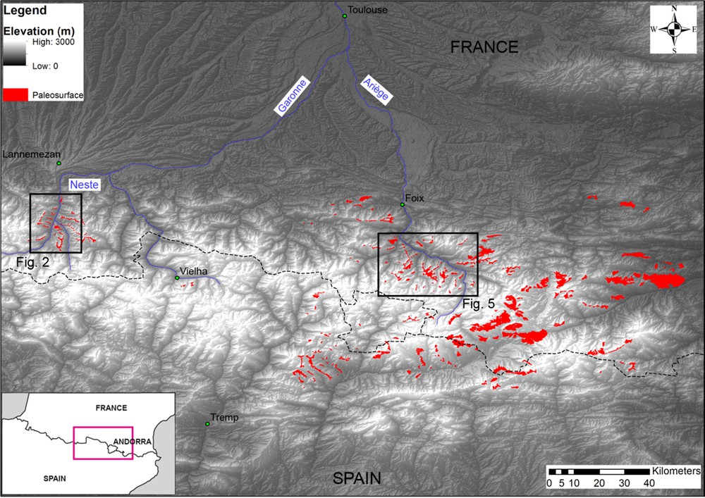
The relief of the Pyrenees and palaeosurfaces mapped within the mountain belt. The compilation of palaeosurfaces is derived from the computation of slopes lower than 10°, and from Calvet (1996) and Delmas (2009). Fig. 2: Bordères–Louron area; Fig. 5: Aston area. Dashed line is the border between France and Spain, with Andorra in the middle.
The nearby Massif Central is known to have undergone strong weathering phases whose ages are: (i) pre-Late Carboniferous; (ii) pre-Permian; (iii) pre-Triassic; (iv) pre-Liassic; (v) pre-Late Cretaceous; and (vi) Eocene (e.g., Gandolfi et al., 2010; Migoń and Lidmar-Bergström, 2001a; Pierre, 1989; Wyns et al., 2003). During these weathering phases, a weathering profile developed, which, from bottom to top, encompasses bedrock, fissured zone, and alterites (or saprolite), subdivided into a laminated zone and loose saprolite. In plutonic rocks, the fissured zone is characterized by horizontal jointing due to the swelling of some minerals when hydrating, the most efficient one being biotite, whose volume increases by 40% when it is transformed into chlorite or vermiculite (Wyns et al., 2004). The fissure density increases upwards, up to 1 fissure per 10 cm. The alterites consist of highly weathered minerals. In the bottom part (the laminated zone), it is laminated and the original rock structure is still observed, whereas in the upper part the rock is transformed into loose material. The very top of the profile is a planar surface that formed before further weathering, ensuring the necessary low-draining conditions that allow chemical weathering rather than physical erosion. The formation of a weathering profile implies a long duration, 5–10 Ma at least under such low-draining conditions (Wyns, 2002; Wyns et al., 2003). In Europe, excluding subsidence areas, saprolite thickness can reach several tens of metres, but usually less than 50 m (Migoń and Lidmar-Bergström, 2001b; Wyns et al., 2003).
In the Pyrenees, the link between ancient weathering periods and planar surface development has never been investigated. Because plutons and gneisses are good protoliths for the development of weathering profiles, we focused our work on two of such well-developed planar surfaces at Bordères–Louron in the Neste Valley and at Aston in the Ariège Valley, within the central and eastern Pyrenees, respectively (Fig. 1).
2 Planar surfaces of the central and eastern Pyrenees
In the Nestes Valley, the 310-Ma-old Bordères–Louron pluton is exposed southeast of Arreau, the main village (Gleizes et al., 2006). It is centred on Bordères–Louron (0.38°E; 42.88°N), a village lying within the Louron Valley at 850 m asl. The granite intruded Early Carboniferous shale and limestone, and is unconformably overlain by Triassic sandstone and shale (Fig. 2). Where preserved, planar surfaces appear mostly on top of the interfluves, well above the main moraine systems and associated glacial deposits. Many villages are settled on the most prominent surface, as Lançon for at ∼ 1100 m asl (Figs. 2 and 3). To the east and southeast, this main surface can be connected to smaller remnants, mostly located along the Louron Valley, for example around Ilhan and Ris villages, at similar elevations of 1100 and 1120 m asl, respectively (Fig. 4). In addition to these sub-horizontal surfaces, the landscape exhibits low-relief morphology up to 1360 m above Lançon village. Weathered rocks outcrop below every surfaces of the area.
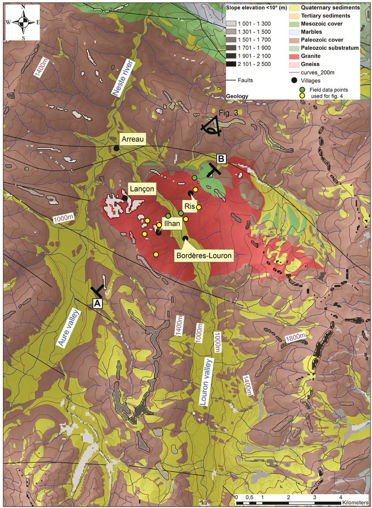
Simplified geological map of the Bordères–Louron area, derived from the 1/50 000 geological map (Barrère et al., 1984), showing the location and elevation of the computed surfaces (the DEM was created by IGN and has a resolution of 50 m). The colour gradient shows surfaces from light grey for low elevations to black for the high ones. A–B. Location of the cross-section of Fig. 4. View point symbol for Fig. 3.

The Nestes Valley (including Aure and Louron Rivers) observed from the NNE (View point shown on Fig. 2).

NE–SW geological cross-section across the Bordères–Louron granite, showing the elevations of the different surface levels, such as the main one at 1100 m asl. See location in Fig. 2.
The Aston area lies mostly south of the N120E-trending Ariège Valley for ∼ 20 km between Tarascon and Ax-les-Thermes (1.7°E; 42.7N), with a valley floor at ∼500 m asl. It is characterized by 5–10 km wide planar surfaces, as already indicated by local names, such as “plateau” or “pla”, the best known being the Plateau de Beille on which is built a Nordic skiing station (∼ 1800 m asl). The main surface, which we called Aston surface, is developed at elevations between 1300 and 2100 m and gently dips north with an average slope of 3 to 5 degrees. The Aston planar surface developed over various lithologies, the most common being the Riète Gneiss formation (Fig. 5A). A section parallel to the Ariège Valley, five kilometres to the south (Fig. 5B), shows the different plateaus, separated by three valleys, defining a dissected low-relief surface. To the north of the Aston massif, near the Ariège Valley, the surface is associated with stepped surfaces at lower elevations: two levels are observed at 1700–1800 m and at 1300–1500 m. These surfaces are of similar origin as weathered rocks equally mantle them. The main step and some smaller offsets of these surfaces trend N110°, quite parallel to the North-Pyrenean Fault (Fig. 5).
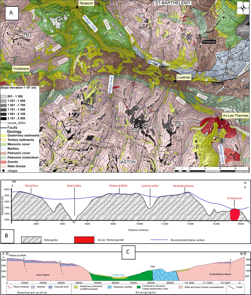
A. Simplified geological map of the Aston area, derived from the 1/50,000 geological map (Destombes et al., 1969), and location of the surfaces (colour gradient from light grey for low elevations to black for high ones). PB: Plateau de Beille; PF: Pla du Four; PBr: Pla de Bourbourou; PdM: Pla du Mont; PT: Pla de Tabe; PM: Pla de Madame. A–B: Location of the cross-section. B. NW–SE cross-section from Pla du Four to Ax-Bonascre. The thalwegs are made by planar surfaces used to define the envelope surface. This surface is interrupted by incised valleys like the Aston one. The surface deflection between Pla de Bourbourou and Ax-Bonascre is concomitant with a step. C. North–south cross-section from the Plateau de Beille to the Saint-Barthélémy summit, showing the stepped surfaces and preserved alterites controlled by normal faults (not mapped in Fig. 5A) on both sides of the Ariège River (see the text for further explanations).
The Aston area is thus characterized by a ∼ 10 × 20 km2 set of related surfaces, whose morphology is a northwest-trending low-relief glacis that has been dissected since the development of these surfaces.
3 Weathering
In both study areas, the planar surfaces are developed over significantly weathered rocks that are directly exposed. On granitic and gneissic rocks, the weathered profiles exhibit a common organization of the successive weathered horizons (Fig. 6). In addition to the macroscopic study of the weathered profiles, X-ray and microscopic observations on samples taken from the fissured zone indicate the presence of supergene minerals like goethite or lepidocrocite on both sites.

A. Sketch of a granite weathering profile. The arenites and the laminated zone define the unconsolidated alterite unit. The fissured zone is about twice as thick as the unconsolidated alterite. Photographs show unconsolidated alerites of the weathered profile. B. Under the planar surface at Lançon in Bordères–Louron granite. C. Under the Plateau de Beille of the Aston massif in Riète gneiss formation.
In the Bordères–Louron area, the planar surfaces developed on any lithologies and are all associated with unconsolidated alterites (Fig. 4). This is consistent with the 1/50,000 geological map (Barrère et al., 1984). Over the Bordères granite, the surfaces developed on top of unconsolidated quartz alterites (Fig. 6). Fissured granite is observed at the bottom of Louron Valley, about 300 m below the planar surfaces (Fig. 4).
Under the Aston surface, we found both the alterites at the ski station (1800 m asl) and a fissured horizon dipping gently to the north at the summit of the surface (∼1900 m asl) (Figs. 6 and 7). This indicates more pronounced denudation since the weathering period than in the Bordères–Louron area. Part of the denudation occurred during the Quaternary by glacial dynamics until at least 1450 m asl, where the presence of glaciers is proved by glacial deposits overlying the laminated zone of the Riète Gneiss (Delmas, 2009). However, the glacier may have reached an elevation of 1900 m asl (Delmas et al., 2012).

A. Fissured horizon under the Aston surface at Plateau de Beille (1900 m asl). B. Fissured horizon in the gneissic rocks of the southwestern flank of Saint-Barthélémy (1600 m asl). Open fissures are underlined by thick lines, foliation (S1) is represented by white lines.
Observation of landscape together with the analysis of the weathering profile indicates that the Aston surface extends to the northern side of the Ariège Valley. We clearly observed surface remnants both in the southwestern Saint-Barthélémy massif flank, where a fissured horizon in gneiss gently dips northward (Fig. 7), and on its southeastern flank around Trimouns and Chioula. On the northern flank of the Aston massif, the surface is lowered by N110-trending faults towards the Ariège River (Figs. 5C and 8). North of the river, the surface is affected by south-dipping faults, but crosses the North-Pyrenean fault without offset. Normal faults cross-cut the weathering profile, preserving alterites on the lowered fault block (Fig. 5C).

3D view of the modern Ariege Valley between Ax-les-Thermes and Tarascon, and the reconstructed palaeo-weathering surface. At Ax-les-Thermes, the current Ariege river level is 700 m below the reconstructed surface.
4 Discussion
4.1 Estimating the age of the surfaces
Theoretically, the best method for dating weathering stages is to date supergene minerals, e.g., cryptomelane (Beauvais et al., 2008) or goethite (Shuster et al., 2005), or palaeomagnetic dating (e.g., Ricordel-Prognon et al., 2010). However, up to now, none of these methods was successful in our study area, and we have to use published ages obtained from surrounding sites for discussing the formation age of the surfaces.
For many granite plutons in the Pyrenees, fission tracks and (U–Th)/He dating on apatites indicate major cooling between 40 and 30 Ma ago (Fitzgerald et al., 1999; Gunnell et al., 2009; Jolivet et al., 2007a; Morris et al., 1998; Sinclair et al., 2005). These low-temperature thermochronological ages correspond to periods of significant denudation that preceded weathering. Moreover, micro-mammalian assemblages in superficial rock fissures within the surfaces in the eastern Pyrenees (Madres and Agly massifs) show that little erosion occurred since 26 Ma (Gunnell et al., 2009).
Based on (U–Th)/He dating on zircons and apatites, the Aston massif underwent major denudation at 32–40 Ma (Denèle, 2007). South of the Aston massif, the Hospitalet massif yields younger ages, 28–34 Ma (Denèle, 2007), suggesting a slightly faster denudation and relative motion related to tectonic deformation along the Merens fault separating the two massifs. The Hospitalet ages indicate that denudation probably lasted until 28 Ma ago. To the southeast, the Canigou and Mont-Louis massifs show similar range of cooling ages with a denudation rate slowing down around 21 Ma ago (Maurel et al., 2002). Northwest of the Aston massif, analyses indicate consistent ages in the Arize and Trois-Seigneurs massifs, with youngest (U–Th)/He Oligocene ages on apatites (Vacherat, 2014).
Thermochronological data are also available from the southern flank of the central Pyrenees. The Maladeta massif shows a palaeosurface associated with a weathering profile (Ortuño, 2008; Ortuño et al., 2013). Pollen collected within small basins showed the surface predates the Vallesian (11.1–8.7 Ma). Low-T thermochronology indicates rapid denudation that decreased after 30 Ma (Fillon, 2012; Fitzgerald et al., 1999; Gibson et al., 2007; Sinclair et al., 2005). This Eocene–Oligocene denudation episode led to infilling of the valleys, about 9 Ma ago (Fitzgerald et al., 1999; Fillon and van der Beek, 2012).
To sum up, the weathering profiles associated with the surfaces may have developed between the Eocene–Oligocene and the Late Miocene (Calvet, 1996; Hautmann and Lippolt, 2000; Migoń and Lidmar-Bergström, 2001b), and thus seem to be related to the Pyrenean orogeny. This agrees with the earlier interpretation by Hautmann and Lippolt (2000), who considered that Neogene weathering episodes were controlled tectonically rather than climatically. Development of the weathering surfaces seems to have ended around 10 Ma ago, and their subsequent disappearance was probably driven by incision and relief rejuvenation, as is shown by the Pliocene deposits filling the valleys in the northern Pyrenean piedmont (Monod et al., GARVEMIP working group, 2014).
4.2 Reconstructing the planar palaeosurface
Our work allows reconstructing the geometry of the surfaces (Figs. 5 and 8). The Aston surface has a relatively simple geometry, while the Bordères–Louron surface is slightly more complicated. We thus mainly focus our interpretation on the first one, for which more data are available. The reconstructed surfaces top intermediate interfluves and are connected with the foothills of the highest reliefs (see for example the southern boundary of the Aston surface, Figs. 8 and 9). In our interpretation, these piedmont surfaces correspond to an episode of relief (difference in elevation between thalwegs and crests) decrease, and were later incised by deep valleys, partly of glacial origin. Our reconstructed surface for the Aston area shows low relief, resembling a gently dipping wide glacis between some higher ground. The latter was smooth and shaped during a period of relief decrease, probably corresponding to the reworking of higher surfaces (Gunnell et al., 2009). On the basis of the low-temperature thermochronology data (Denèle, 2007; Maurel, 2003; Morris et al., 1998), we suggest that these reliefs were less than 1000 m above the piedmont, as a greater height seems impossible. Our reconstruction fits Goron's (1937) observations, who noted that these surfaces are at about 1200 m on the northern side of the range, well above the current piedmont elevation, implying either infilling of the piedmont basin or uplift of the range after their development.
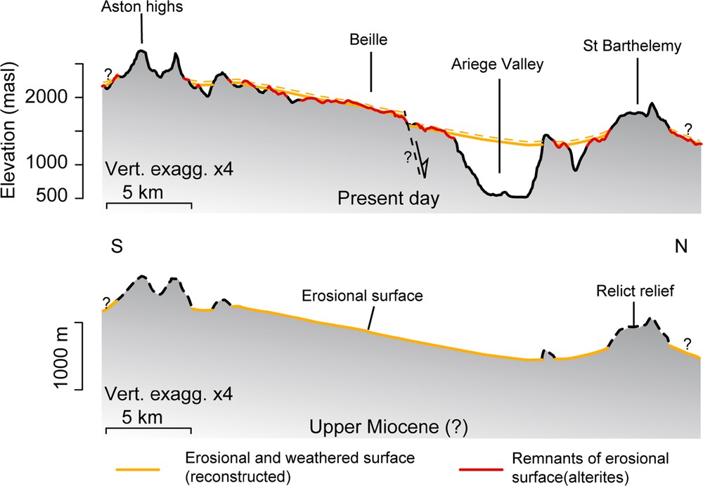
Surface development and incision: the example of Aston/Plateau de Beille. By the end of Miocene, an erosional surface associated with a weathered surface (alterites) shaped the valleys between remnants of relief built during the Pyrenean orogeny (unknown in dashed lines). Since the Miocene, this surface has been denudated by no more than 50 m (dashed yellow line) and partially dissected by incision.
Such perched piedmont surfaces allow estimating the subsequent denudation that affected this area of the Pyrenees. The denudation was twofold: on the surfaces, it corresponds to surface lowering, while in valleys, it corresponds to incision after the surface developed. First, the weathered rocks below the surface remnants indicate that saprolite stripping is not complete and less than 50 m; this value of 50 m thus is an upper boundary for surface lowering by weathering since their formation (and probably before incision, as discussed below). Second, we measured the incision to be 200–250 m in the Louron Valley (Fig. 4) and 850 m in the Ariege and Aston valleys (see Figs. 5 and 9). In the Aston area, the average incision can be measured as the difference between the current DEM and the reconstructed surface, i.e. about 300 m.
Consequently, if we consider an age of ∼ 10 Ma for the surfaces, the upper boundary for an average denudation rate is around 5 m/Ma for the surfaces themselves (without incision), a value typical for low-erosion areas as indicated by cosmogenic nuclides (Portenga and Bierman, 2011) and by modern fluxes (Summerfield and Hulton, 1994). For the entire Aston area, the denudation rate must be about 350 m (300 m of average incision and 50 m of weathered surface lowering). This corresponds to 35 m/Ma and maybe much more (up to 300 m/Ma), if we consider valley carving as having occurred mostly during the last 1 Ma, similarly to the data for Alpine valleys (Valla et al., 2011).
Surface remnants are found all through the Pyrenees, but the present work is too preliminary to prove that they all have a similar history to that shown in Fig. 9, as suggested by Goron (1937). For instance, the Aston surface may be older than the Borderes one, since it has recorded more denudation. However, close to the study areas, the Canigou (to the southeast) and Maladeta (to the south) massifs seem to have undergone a similar evolution: strong denudation ending in the Oligocene, making place for surface- and weathering profile development before incision after the Miocene (e.g., Gunnell et al., 2009; Ortuño et al., 2013). The latter incision would have been triggered by uplift (Calvet and Gunnell, 2008) or piedmont infilling by regressive erosion (Babault et al., 2005).
4.3 Surface faulting
In our study area, the Aston surface is deformed by normal faults with facet-like morphologies, oriented N110, thus paralleling some of the main tectonic boundaries, though as yet no visible striation on the fault surfaces was seen. The north-dipping high-angle faults expose a fissured zone in the footwall and unconsolidated alterites in the hanging wall. This structure is found from the summit of the Aston surface to the river level, giving the Ariège Valley a graben shape. Interestingly, Ortuño et al. (2013) describe a similar weathered surface from the Maladeta (assigned to Vallesian, cf. before), offset of around 440 m by the N100-trending normal Maladeta fault. Thus, a N110 normal faulting in Aston is considered possible (offset of about 150 m). The structure described here is consistent with post-Miocene extension in the Pyrenees, as already proposed by earlier studies dealing with active tectonics (Lacan, 2008; Lacan and Ortuño, 2012; Ortuño, 2008), normal focal mechanisms (Chevrot et al., 2011), and digital models (Vernant et al., 2013).
5 Conclusions
We describe planar surfaces associated with highly weathered rocks in the Pyrenees, based on the examples in the Bordères–Louron (central Pyrenees) and Aston (eastern Pyrenees) areas. We conclude that these surfaces are postorogenic and developed between 30 Ma and 10 Ma ago. After that, they were abandoned during rejuvenation of the relief, involving either regional uplift or large-scale regressive erosion. These surfaces, which are found throughout the Pyrenees, represent outstanding morphological markers for analysing the postorogenic processes, notably the question of the extensional tectonics that seems to have occurred recently.
Acknowledgements
This work has been carried out with the support of the RGF (“Référentiel géologique de la France”) funding. Additional funding was provided by the POTAPYR project. VR and JC are grateful to D. Beziat, M. Thibault, and D. Guillaume for optical and DR-X determinations of lepidocrocite and goethite. We thank M. Calvet, S. Carretier and C. Gautheron for fruitful discussions. We thank the two reviewers P. Lacan, J.-F. Ritz and Associate Editor Y. Lagabrielle for thorough and constructive reviews that contributed to improve the manuscript. Dr H.M. Kluijver edited the English of the manuscript.