

1 Introduction
Moving plate tectonics and deep mantle dynamics create uplift and subsidence of the Earth's surface, whereas Earth's surface processes, namely erosion, transport and sedimentation, tend to counteract these positive and negative vertical movements. Uplift (or subsidence) has two origins: isostasy that is controlled by the difference between crustal and mantle densities, and dynamic topography that is controlled by mantle dynamics (e.g., Molnar and Houseman, 2013). Wavelength and elevation changes for local isostasy are respectively of several tens to hundreds kilometers and up to several kilometers, whereas for dynamic topography they are typically of several hundred to thousand kilometers, and several hundred meters up to one kilometer, respectively (e.g., Braun, 2010). Whether or not surface uplift equates to rock uplift depends on whether or not erosion is active (England and Molnar, 1990). As surface uplift is controlled by crust and/or mantle dynamics, the resulting elevation change must be considered in terms of mean elevation at a minimum area of a thousand of square kilometers (e.g., England and Molnar, 1990). In a general way, crustal thickening causes surface uplift. The growth of a mountain belt by crustal thickening requires a rate of erosion much lower than the rate of rock uplift. When increasing erosion rate tends to equate to rock uplift rate, a dynamic equilibrium occurs once the mountain belt has risen. Crustal thinning will result in surface lowering that can be partially compensated for by sedimentation and/or by concomitant thinning of the lithospheric mantle. Extreme thinning of the continental lithosphere inevitably causes surface lowering below sea level. Only thinning of the lithospheric mantle and its concomitant replacement by less dense asthenospheric mantle can produce surface uplift when crustal thickness is kept constant. So, any attempt to determine the evolution of the topography requires investigating both Earth's surface and deep processes at the origin of the relief (e.g., Casas-Sainz and de Vicente, 2009; Molnar et al., 2015). The Pyrenees is an emblematic example: how the topography of the belt has changed over time and what were the deep processes involved is highly debated.
The Pyrenees are classically described as an intracontinental orogen that results from the inversion of a continental rift during the convergence between Eurasia and Africa (Choukroune et al., 1990; Muñoz, 1992). Beyond the considerable debate that is currently concerned with the width of this rift that developed during the Cretaceous and resulted in mantle exhumation (Jammes et al., 2009; Lagabrielle and Bodinier, 2008), no doubt exists that crustal thickening was at the origin of the Pyrenees uplift during Eocene and Oligocene times. Indeed, the Moho beneath the central Pyrenees reaches a depth of about 50 km (Chevrot et al., 2014; Choukroune et al., 1990).
The “Pyrenees” geographic and geomorphologic labels differ from the Pyrenean orogen (“tectonic” Pyrenees). The Pyrenean orogen extends from the Cantabric Range in north-western Spain to the west, to Provence in south-eastern France to the east. The initial chain was about 1000 km in length, whereas the geomorphologic Pyrenees are only 400 km in length. The disappearance of the Pyrenean orogen below the Mediterranean is due to the tectonic collapse of the former during considerable Oligocene to Aquitanian crustal and lithospheric thinning in the Gulf of Lion margin and subsequent oceanic accretion in the NW Mediterranean (Séranne et al., 1995). This event succeeds the continental rifting that developed in Western Europe from the Oligocene. It also affected the easternmost part of the geomorphologic Pyrenees. We refer hereafter the geomorphologic Pyrenees to the Pyrenees.
2 The high-elevation, low-relief erosional surfaces in the Pyrenees
The most striking feature of the Pyrenean morphology is the occurrence at high elevation of low-relief erosional surfaces, which are considered as remnants of a single composite planation surface recently dissected (Babault et al., 2005; Calvet, 1996; de Sitter, 1952; Kleinsmiede, 1960; Zandvliet, 1960). This planation surface erodes the Pyrenean tectonic structures and is locally overlapped by Upper Miocene continental deposits in the Val d’Aran and Cerdanya, providing an upper limit age for its development (Cabrera et al., 1988; Roca, 1996; Ortuño et al., 2008, 2013; de Sitter, 1953). The high-elevation, low-relief surfaces form smooth reliefs paradoxically situated at crest zones up to ∼2800 m asl in the Axial Zone of the Pyrenees (Fig. 1). They occur irrespective of lithology, mainly granitic rocks and micaschists. Typically, the slope along these surfaces does not exceed 20°. Depending on their altitude in the chain, they are more or less disrupted by glacial erosion. Within the high-elevation, low-relief surfaces, glacial erosion produces excavation surfaces, easily identifiable by their concave-up geometry, their steep slopes and their marked roughness. To reconstruct the Pyrenean planation surface, we analyzed and mapped several remnants of this surface and we used literature data to compile a regional map (Babault et al., 2005; Calvet, 1996; Kleinsmiede, 1960; Ortuño et al., 2008; Zandvliet, 1960). Then we used an automatic method of landform classification called TPI (Topographic Position Index; Jenness et al., 2013; Weiss, 2001) to map these remnants across the Axial Zone of the Pyrenees.

(Color online.) Examples of high-elevation, low-relief surfaces in the Axial Zone of the Pyrenees. Field examples (left) and corresponding topographic maps (right) (location in Fig. 2). Top: Pla d’Envalira (Andorra) (2500 m asl); middle: Pla de Boldis (Cardos Valley) (2500 m asl); dashed line: ECORS profiles; bottom: Pla de Prüedo (Val d’Aran) (2000 m). These surfaces have been previously mapped by Kleinsmiede (1960), Zandvliet (1960), Calvet (1996), and Ortuño et al. (2008). The color in surfaces represents its elevation. Masquer
(Color online.) Examples of high-elevation, low-relief surfaces in the Axial Zone of the Pyrenees. Field examples (left) and corresponding topographic maps (right) (location in Fig. 2). Top: Pla d’Envalira (Andorra) (2500 m asl); middle: Pla de Boldis (Cardos Valley) (2500 m ... Lire la suite
The Weiss method uses digital elevation models to measure the difference between the elevation of each cell and the mean elevation with a variable radius of calculation. The variation of the radius, the TPI type and the slope permit to distinguish different landforms in the landscape. We use 25-m resolution DEMs from the French, the Spanish and the Andorran Geographical Institutes, allowing us to detect areas down to 500 m2. TPI type, TPI radius and slope were determined from surfaces previously mapped by field investigations. We have developed the methodology. It will be the subject of another publication. The applied methodology results in a limit between the remnants of the planation surface and glacial landforms more consistent and regular than using traditional interpretative mapping (Fig. 1). We then verify on the field the existence of the surfaces identified by the Weiss method, which were not previously mapped.
Fig. 2a shows the pervasive occurrence of the remnants of the Pyrenean planation surface in the Axial Zone. Hypothesizing that these surfaces are the remnants of a single paleosurface of planation, we tentatively restore this latter by interpolating the neighboring remnants (Fig. 2b). The resulting surface is gently undulating with a mean elevation of about 2400 m. Local relief does not exceed 300 m (Fig. 2c). This surface can therefore be described as a high peneplain (Davis, 1899; King, 1953). Note that the mean elevation of the restored planation surface is some hundred meters higher than the mean elevation of the present-day topography.

(Color online.) The planation surface of the Pyrenees. A. Top: map of the different remnants of the Pyrenean planation surface; bottom: map of the planation surface obtained by the interpolation of neighboring remnants using GOCAD 3D modeler. B. East–west and north–south profiles of the restored planation surface (red). Thick black lines: mean elevation.
3 Moho depth and deep structure in the Pyrenees
The first works on the Moho depth below the Pyrenees (Choukroune and ECORS Team, 1989; Daignières et al., 1982; ECORS Pyrenees team, 1988; Roure et al., 1989; Souriau and Granet, 1995; Vacher and Souriau, 2001) have revealed the presence of a crustal root that corresponds to the thickening of the Iberian crust during the incipient subduction of the Iberian lithosphere below the European lithosphere. Recent studies coupling receiver functions and local tomography investigation have provided more accurate images of both the crustal and lithospheric structures below the Pyrenees (Chevrot et al., 2014).
In order to compare independently geophysical approaches for the calculus of the depths of the Moho and of the base of the lithosphere, we present a new geophysical modeling using topographic data and geoid anomaly together with thermal analysis in a 1D approach (Fullea et al., 2007; Robert et al., 2015). Topographic and bathymetric data are extracted from the ETOPO1 database (Amante and Eakins, 2009) and the geoid anomaly from EGM2008 global model (Pavlis et al., 2008). In order to avoid sub-lithospheric density variations, we filtered the geoid so that the signal corresponding to the lower spherical harmonics until degree and order 10 is ruled out. Our modeling approach assumes that (1) local isostasy is verified, considering a depth of compensation of 300 km, and (2) the system is in thermal equilibrium. It also considers a four-layered density model composed of atmosphere/sea water, crust, lithospheric and asthenospheric mantle. The crustal density linearly increases with depth, and the density of the lithospheric mantle is temperature dependent.
Fig. 3 shows three models involving variable crustal densities (Table 1). We compare the Moho depths with the dataset from Chevrot et al. (2014), which involves recent receiver functions data and reflection–refraction profiles from France and Spain (see references in Chevrot et al., 2014). We perform a new interpolation of the Moho surface from Chevrot et al.’s dataset, using the 3D GOCAD modeler (Mallet, 2002). This interpolation reveals the main pattern of the Moho surface, avoiding short wavelength variations (Fig. 3).
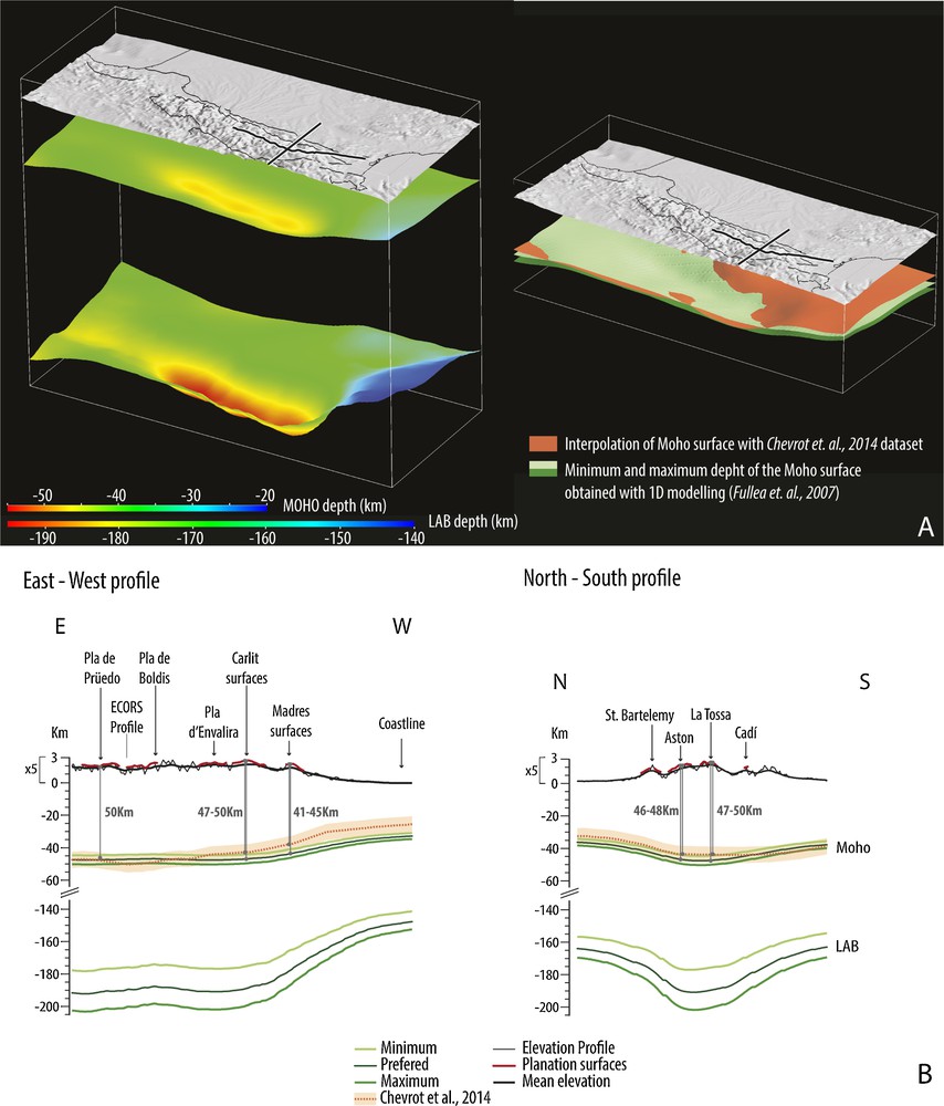
(Color online.) 3D superposition of topography, Moho and LAB in the Axial Zone of the Pyrenees. A. Left: Superposition of the three surfaces (topography, Moho and LAB) (see text for further explanation). A. Right: Topography and Moho surfaces. The figure shows the comparison between the Moho surface interpolated from Chevrot et al.’s dataset (orange) and three Moho surfaces and the corresponding LAB surfaces (green) resulting from the 1D gravity modeling using different three crustal densities (see Table 1 for parameters). B. East–west and north–south profiles of the three surfaces (topography, Moho and LAB). Thick black lines correspond to the mean elevation. The red line corresponds to the remnants of the planation surface. The orange line is the Moho profile from Chevrot et al.’s dataset (the margin of error (± 5 km) is shown). The green lines are the profiles of the Moho and the corresponding LAB resulting from 1D gravity modeling. Masquer
(Color online.) 3D superposition of topography, Moho and LAB in the Axial Zone of the Pyrenees. A. Left: Superposition of the three surfaces (topography, Moho and LAB) (see text for further explanation). A. Right: Topography and Moho surfaces. The figure ... Lire la suite
Parameters used in the 1D modeling using topographic data and geoid anomaly together with thermal analysis.
| Minimum | Preferred | Maximum | |
| Densities (kg/m 3 ) | |||
| Sea water density ρw | 1031 | ||
| Upper crust density ρc.up | 2660 | 2760 | 2810 |
| Lower crust density ρc.dw | 2900 | 2900 | 2950 |
| Mean crust density ρc.m | 2780 | 2830 | 2880 |
| Lithospheric mantle density (ρl) | 3200 [1 + 3.5·10−5 × 3200(1300–Tm)] | ||
| Asthenosphere density (ρa) | 3200 | ||
| Thermal parameters | |||
| Kc | 2.7 W·K−1·m−1 | ||
| Km | 3.2 W·K−1·m−1 | ||
| Ts | 15 °C | ||
| Ta | 1300 °C | ||
| α | 3.5·10−5 | ||
| H0 | 0.7 mW·m−3 |
The three models are in agreement with the Moho depth determined from the dataset of Chevrot et al. (2014). We observe that the mean elevation of the Pyrenees is generally compensated by crustal thickening, so that the variation of elevation across the chain matches that of the Moho depth. Similarly, the base of the lithosphere parallels the Moho surface, and does not show any anomalous thickening or thinning that could trigger the mean elevation of the chain.
In the easternmost Pyrenees, the Moho and the lithosphere–asthenosphere boundary rises progressively whereas the mean elevation of the chain decreases. Lithospheric thinning increases offshore in relation with the opening of the Gulf of Lion (e.g., Séranne, 1999). In this area, there is a misfit between our models and the data set of Chevrot et al. (2014) that does not exceed 5 km. Whether this misfit has to be related to the error inherent to both methods (Gómez-Ortiz et al., 2011; Molnar et al., 2015) remains to be determined. Our density model for the crust is probably not fully pertinent in this area where the thick Neogene sedimentary cover makes the mean crustal density lower than in the rest of the Pyrenees. To what extent this affects the results of our modeling is to evaluate. Further investigation, especially 2D and 3D modelling, is needed to improve the fit (work in progress).
4 Discussion
The above considerations about the “Pyrenees” labeling highlight the prominent part played by isostasy on the surface expression of the Pyrenean orogen as a whole. We argue here that isostasy, and not mantle dynamics, is responsible for the occurrence of low-relief erosional surfaces at high elevation in the Pyrenees.
Low-relief erosional surfaces are considered to be produced by long-term erosional processes that result in the peneplanation near sea level of earlier reliefs such as mountain belts (Davis, 1899). Thus low-relief surfaces at high elevation at the Earth surface are classically interpreted as a result of a surface uplift (e.g., Chorley et al., 1973; Davis, 1899; de Sitter, 1952; Farías et al., 2008; Hetzel et al., 2011; Phillips, 2002). Uplift generates relief rejuvenation so that these surfaces appear as relics of a dissected peneplain. Mantle dynamics is required to trigger surface uplift because these relics appear rather flat and not deformed, while considerable crustal thickening would inevitably induce their folding and faulting. A major consequence of such an interpretation is the lack of crustal root together with an extreme thinning of the lithospheric mantle below these surfaces (Fig. 4a). In the eastern Pyrenees a similar interpretation involving a near-2000-m post-orogenic uplift has been proposed for the high altitude of these low-relief surfaces (e.g., de Sitter, 1952; Gunnell et al., 2008).
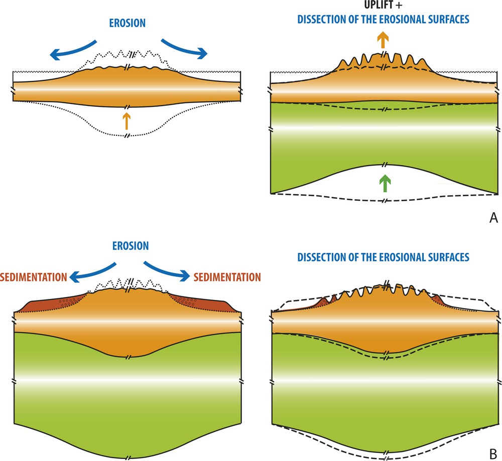
(Color online.) Two end-member conceptual models for the explanation of high-elevation, low-relief erosional surfaces. A. Model 1 considers planation near sea level, then uplift triggered by mantle dynamics and relief rejuvenation. Note the absence of crustal root below the dissected peneplain. B. Model 2 considers planation at high elevation due to erosion inhibition emphasized by thick piedmont sedimentation and the persistence of a crustal root below the high-elevated planation surface.
The present preliminary results show that these surfaces are ubiquitous in the Pyrenees. Their interpolation at the scale of the chain suggests that they are remnants of a single, gently undulating planation surface. The elevation variation of the latter follows that of the present-day mean topography, which appears to be in isostatic equilibrium. We do not find any crustal overcompensation of the elevation of the chain as previously suggested (Vacher and Souriau, 2001) or anomalous thinning of the mantle lithosphere to explain the elevation of the planation surface in the eastern Pyrenees (Gunnell et al., 2008). Our results therefore contradict the hypothesis of peneplanation near sea level, and subsequent uplift due to mantle dynamics (Fig. 4a).
The difference in altitude between the restored planation surface and the present-day mean topography of the Pyrenees is explained by the isostatic rebound due to the dissection of the former (Babault et al., 2005). This difference in altitude stems from the fact that our restoration ignores the isostatic rebound consecutive to recent dissection of the planation surface (Babault et al., 2005).
Additionally, the present-day level of erosion in the central and eastern Pyrenees also disagrees with the hypothesis of peneplanation near sea level. The peneplanation of an initial mountain belt with a mean altitude of 2000 m asl would require to remove by erosion a crustal thickness of about 12 km. The rocks exposed along the peneplanation surface would therefore show a metamorphic imprint corresponding to a minimum burial of 12 km. The Hercynian basement in both the central and eastern Pyrenees show a remarkable similar metamorphic zonation (e.g., Carreras and Capella, 1994) that reveals a similar level of erosion. To our knowledge, there is presently no data to support a differential 12-km crustal thickening during Pyrenean tectonics between the central and eastern Pyrenees. So in the easternmost Pyrenees, thinning of the crust is not achieved by greater erosion, resulting in downwearing and peneplanation, as previously suggested (Gunnell et al., 2008). Crust thinning rather results from Upper Oligocene to Lower-Miocene extensional tectonics (Séranne, 1999).
We conclude that the high-elevation, low-relief surfaces of the Pyrenees are the remnants of the single planation surface. This surface formed at high elevation in response to the progressive inhibition of erosion, as shown by thermochronological data (Fitzgerald et al., 1999; Gibson et al., 2007; Gunnell et al., 2009) and the concomitant sediment aggradation along the Pyrenean piedmonts during the mountain growth from the Late Eocene to the Early Miocene (Babault et al., 2005, 2007). This process allowed the preservation of a thick crustal root below the Pyrenees (Fig. 4b). Reactivation of fluvial incision and glacial erosion is responsible for the removal of thick detrital sediment accumulation and the dissection of the initial planation surface into disseminated remnants as observed today (Babault et al., 2005). According to the Molnar and England's model (1990), if any post-tectonic uplift of the planation surface did occur in the Pyrenees, it was caused by isostatic rebound consecutive to erosion and did not exceed 400 m (Babault et al., 2005). Whether relief rejuvenation occurs during the Plio-Quaternary climate change or from the Early Miocene onwards (e.g., Babault et al., 2005, 2006; Coney et al., 1996; Fillon and van der Beek, 2012; García-Castellanos et al., 2003) is still a matter of debate and behind the scope of the present study.
5 Conclusion
Remnants of planation surfaces at high elevation are ubiquitous in the Pyrenean Axial Zone. A first attempt to interpolate these remnants suggests that they correspond to a single planation surface that was completed before the Late Miocene and later dissected. The presence of a crustal root together with the absence of lithospheric mantle thinning below the Axial Zone precludes any peneplanation near sea level before the Late Miocene. This also implies that no subsequent uplift triggered by mantle dynamics occurred as classically proposed to explain such planation surface remnants at high elevation. Rather, in the case of the Pyrenees, it favors a process of erosion inhibition at high altitude, a process probably undervalued in many other mountain belts where remnants of planation surfaces are observed.
Acknowledgements
We are grateful to the BRGM (Bureau de recherches géologiques et minières) for funding the Gemma V. Bosch PhD thesis (Project RGF, “Référentiel géologique de la France”). We wish to thank constructive thorough reviews by Antonio Casas-Sainz, Michel Séranne, and Yves Lagabrielle. Annabelle Bernard is thanked for field assistance.
Vous devez vous connecter pour continuer.
S'authentifier