

1 Introduction
In southern Morocco, the Cretaceous deposits of the easternmost part of the Tarfaya–Lâayoune–Boudjour Basin (TLBB) or Tarfaya–Dakhla Basin as also known in the literature (Fig. 1A), onlapping the Palaeozoic basement, remain poorly studied since the pioneer work of Choubert et al. (1966). Most recent studies have focused on the western, coastal part of the basin and the connection with offshore deposits, mostly for oil exploration or water supplies. Two subbasins, the Tarfaya and the Smara–Laayoune subbasins, were studied as part of a Cooperative Programme between the Universities of Agadir (Morocco) and Lorraine (France), in order to refine the stratigraphy and depositional environments of Cretaceous deposits pinching out on basement rocks of the southern termination of the Anti-Atlas and the Reguibat Shield. Here are presented the field data acquired in the Smara area. Those of the Tarfaya subbasin are under completion. A special focus is also given on Cenomanian–Turonian boundary deposits (Cenomanian–Turonian Boundary Event or CTBE). This event, also known as Oceanic Anoxic Event 2 (OAE2), has attracted much attention over the past decades on a worldwide basis (see Kuhnt et al., 2009, 2017, and references therein for the Tarfaya subbasin, which hosts the CTBE black shale). But few is known on the corresponding proximal shallow-water deposits, devoid of organic-rich shales. In this respect, still unpublished results regarding the southern shoulder of the Atlas belt have been integrated for comparison in the present study, as part of a continued effort (Grosheny et al., 2017a, 2017b) to track a possible tectonic imprint on the CTBE environmental event on a large scale.
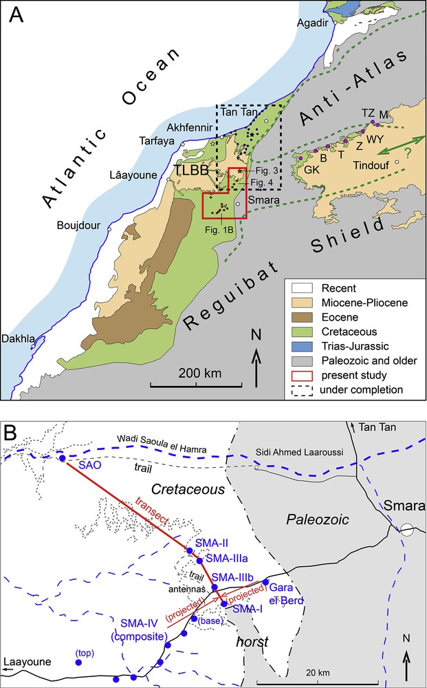
Location of the study area. A, Simplified geological map showing the area of study (Laâyoune sub-basin), including that of a companion one under completion (Tarfaya sub-basin), and whose results are partially cited in the text. The dotted heavy green line representing the early Turonian shoreline at maximum transgression, as discussed in the text. Localities cited in Choubert et al. (1966) on the northern border of the Tindouf syncline, and discussed in the text, are also indicated (B, El Bouirat; GK, Gour Kneifida; M, Merkala; T, Touiela (Garet el Houissane); TZ, Tarf Zaïda, Z, Zaak, or Zag). White star, location of Puerto Cansado well; black star, location of Wadi Chebeika. B, detailed map of the Smara area with the location of the logged sections (blue dots).
Six sections have been logged west of Smara, in order to reconstruct a transect (Fig. 1B). The Cretaceous coastal onlap is complicated here by the presence of a horst of Palaeozoic deposits. These data are complemented with sections logged farther north, along the road from Smara to Tan Tan towns, where it is possible to trace the thin coastal sequences in detail over tens of kilometres. Mapping of sequences in this area also give evidence of a disconformity between fully marine sequences and underlying, mixed, continental–marine sequences, whose ages are discussed.
In studying sections, attention has been mostly paid to depositional facies and to identify stratigraphic surfaces having a sequence stratigraphic interest.
2 Description of the sections
The precise location of the sections is given in Table 1.
Coordinates of the sections.
| Gara El Berd | 26°39′52″N, 11°54′34″W |
| Saoula El Hamra | 26°51′06″N, 12°15′03″W |
| Smara-I | 26°37′39″N, 11°58′28″W |
| Smara-II | 26°40′26″N, 11°59′52″W |
| Smara-IIIa | 26°40′09″N, 11°59′39″W |
| SMA-IIIb | 26°39′17″N, 11°59′42″W |
| Smara-IV start | 26°36′20″N, 12°02′15″W |
| Smara-IV finish | 26°32′20″N, 12°09′44″W |
2.1 Smara-I section
The section (Fig. 2) is located on the northern termination of a horst of Palaeozoic deposits (Fig. 1B), here represented by Ordovician bedded quartzite bearing Tigilites burrows. The section begins with a bioturbated, very coarse-grained transgressive sandstone bed resting on brecciated Palaeozoic quartzite. It is overlain by a yellowish succession of sandy claystone passing up to mostly dolomite, either fine-grained and bioturbated, or platy, or bearing bivalves casts. A yellowish marlstone makes the passage to a whitish, platy (laminated) limestone bed (B1) about 3 m in thickness, showing aligned, large, spherical black chert nodules in its uppermost part. Yellowish fine-grained dolomite overlain by a massive dolomite bed bearing bivalves casts then follows. It is overlain by a second white limestone bed (B2), about 3 m in thickness, but not laminated as B1, showing a wavy bedding instead.
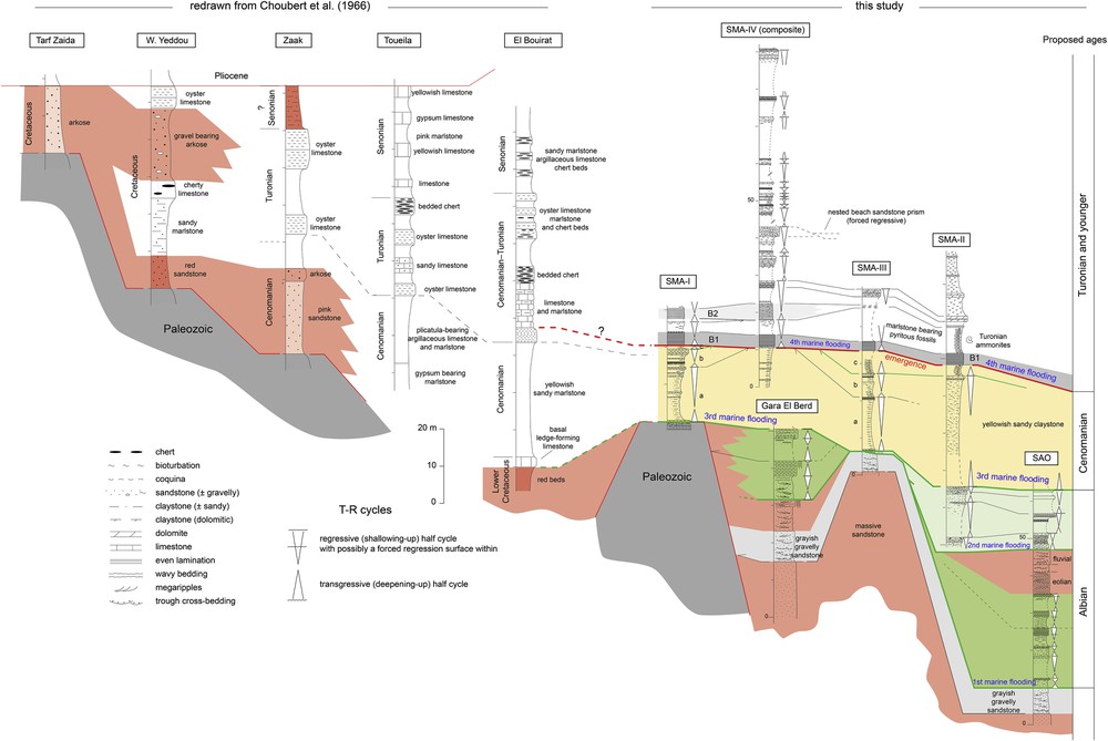
Correlation of the sections in the Smara area. Sequence stratigraphic interpretation in terms of transgressive–regressive (T–R) sequences are indicated along the sedimentological sections. On the left are redrawn the sections published by Choubert et al. (1966) on the northern border of the Tindouf syncline. For location of sections, see Fig. 1A.
The yellowish claystone–dolomite succession under B1 can be interpreted as an overall prograding sequence over the basal transgressive sandstone bed. This sequence is probably to be subdivided into three transgressive–regressive (T–R) sub–sequences (a, b and c, Fig. 2). The first white limestone bed B1 is a laminated restricted deposit, probably representing a maximum flooding, as well as the second, wavy-bedded B2 limestone.
Age assignments (Fig. 2) will be discussed further.
2.2 Smara-II section
This section (Fig. 2) is located in a more distal position than section I. It begins with bioturbated sandstone with thin clayey interbeds, overlain by a sandstone bed bearing branched cherts. After an observation hiatus, a fine-to medium-grained bioturbated sandstone passes up to a coarser-grained sandstone with gravel lenses and indurated beds with low-angle cross-bedding. After a new observation hiatus, a thick sequence of yellowish, bioturbated, very sandy claystone finishes up with a cap of indurated bioturbated sandstone bed, bearing bivalves casts and forming a prominent ledge in the landscape. Above the overlying yellowish marlstone bed, the same platy limestone bed B1 of section SMA-I is found, with about the same thickness. This B1 bed is overlain by about 8 m of yellowish marlstone bearing numerous pyritized ammonites. These marls are overlain by a thin, wavy-bedded white limestone bed, that we interpret as being coeval to the bed of the SMA-I section, given its similar facies. The remaining of the section is an alternation of yellowish fine-grained dolomite and very hard crystalline dolomite forming several ledges in the landscape. No macrofossils have been found in these dolomites.
On a sequence stratigraphic point of view (Fig. 2), the thick claystone–dolomite sequence in the lower half of the section can be easily correlated with the first sequence of the SMA-I section. Its upper shallow facies is thinner than in SMA-I, which can be explained by its more distal position. At the base of the section, at least two additional T–R sandstone sequences are found vs. the SMA-I section. The uppermost dolomites are thought to represent several T–R marl-limestone sequences, but fully dolomitized.
A major discovery in this section are the pyritized ammonites found in the marlstone above the B1 platy limestone. The fauna comprises the following species: Hoplitoides (? Erichsenites) sp., Choffaticeras sp., Nannovascoceras constrictum Renz and Álvarez (1979), indicative of an early Turonian age. As a consequence, the underlying laminated limestone B1 could be a lateral facies of the latest Cenomanian black shale (Oceanic Anoxic Event 2) of the nearby Tarfaya sub-basin (Kuhnt et al., 2009). Other age assignments will be discussed further.
2.3 Smara-III section
This section (Fig. 2) is in intermediate position between SMA-I and SMA-II (Fig. 1B). It was logged along the eastern cuesta supporting the antennas of the Moroccan phone network close to the main road (Fig. 1B). The section is similar to the SMA-II section, except for its base and its summit. At the base, under the thick yellowish claystone sequence of the former two sections, outcrops a yellowish, medium-to coarse-grained, structureless, laterally-continuous sandstone overlain by a light-grey, cross-bedded, very coarse-grained to gravelly sandstone bearing scattered, poorly-rounded pebbles (mostly translucent quartz). This sandstone is overall fining-up. The transition to the overlying yellowish claystone sequence comprises a fine-grained sandstone cut by root casts, and overlain by a bioturbated, coquina-rich, gravelly sandstone bed, which is probably the transgressive facies of the overlying claystone sequence. At the top of the section, above the probable lateral equivalent of the B2 limestone bed, an evenly-stratified coquina sandstone, about 2 m in thickness, is found instead of the crystalline dolomite bed in the nearly SMA-II section. It is probable that such dolomite is the result of the dolomitization of the sandstone cap of the sequence, as it has often been found in similar sandstone-prone coastal deposits of the Upper Jurassic to Lower Cretaceous Continental Intercalaire of southern Tunisia where strata-bound, full transformation of coarse-grained sandstone into massive, isotropic dolomite is very common (Ouaja et al., 2002).
2.4 Smara-IV section
The section (Fig. 2) is a composite one, logged from different outcrops (Fig. 1B) along the road linking Laâyoune to Smara, and stretching over 20 km due to the very low dip. Key beds have been continuously traced in the field to link partial sections. The base of the section is close to the SMA-I section, and shows the same lithologies, up to the second white limestone bed (B2), which is here a little thicker (5 m) and partly dolomitized. The marlstone bearing pyritized ammonites found in the SMA-II section, is also present between the platy limestone bed B1 and the wavy bed B2. The remaining of the section is a complex alternation of claystone to marlstone (most often covered) and shallow-water facies like massive dolomite, laminated dolomite bearing wave-ripples, bioturbated fine-grained limestone, some of these beds being rich in bivalves or gastropods (Nerinea), sandy limestone, and coarse-grained to gravelly, coquina-rich sandstone. The coarse-grained sandstone bed, by the mark 40 m, has been traced over several hundred metres. It shows a laterally-continuous, even or low-angle stratification characteristic of a beach facies. In addition, stratal evidence of forced regression has been found in the nesting of successive beach prisms toward a western (Atlantic) lowstand palaeoshore. The last beds of the section were logged on an isolated outlier, north of the road. Its summit is a coquina-rich dolomite capped by a karstified stromatolite bed, indicating emergence. The upper part of the section, above the lower Turonian ammonite-bearing marlstone, probably covers the upper Turonian, extending possibly into the Coniacian.
2.5 Gara El Berd section
The section (Fig. 2) is logged on the flank of an isolated outlier south of the main road to Smara, in a saddle between the Palaeozoic horst of the SMA-I section and the Palaeozoic cover of the Reguibat Shield to the east (Fig. 1B). At the base, the same massive sandstone and the light-grey, cross-bedded coarse-grained sandstone found in the SMA-III section are outcropping. The remaining of the section is different. A first package of yellowish, megarippled, poorly-cemented sandstone beds capped by an indurated bed of the same facies overlies the light-grey sandstone. Its indurated cap is cut by vertical root casts indicating exposure. This emergence or abandonment surface is overlain by medium-grained, megarippled sandstone bearing numerous clayey rip-up clasts within the bottomsets, presumably indicating a tidal environment. This sandstone unit is sharply overlain by a 4-m-thick coarse-grained sandstone bed bearing laterally-continuous even stratification or low-angle cross-bedding, and also cut by spectacular vertical root casts. A covered recessive interval whose upper part shows a fine-grained sandstone bearing small sinusoidal (? wave) ripples is found below the summital ledge made of the same laterally-continuous, evenly-stratified, coarse-grained sandstone as below, but without the root casts. Its base is also sharp.
On a sequence stratigraphic point of view, the first two sandstone units belong to two successive sequences, given their fully different features. The next unit, under the first root casts surface, is probably fluvial. The next one is considered tidal due to occurrence of clayey rip-up clasts within the megaripples, therefore representing the first evidence of a marine transgression. The two upper, ledge-forming sandstone beds, are probably beach deposits, representing either a full T–R sequence for the lower one, or the shallow-water top of a T–R sequence for the second one. This is quite clear for the first one, with its sharp base and the root casts at its top. The upper ledge could cap, in a forced regressive regime (owing to its sharp base), the underlying fine-grained sandstone of the recessive interval.
2.6 Wadi Saquia El Hamra section
This section (Fig. 2) is located close to the confluence between the main Wadi Saquia El Hamra (SAO) and a little wadi coming from the north. No intermediate section could be logged along the banks of the Wadi Saoula El Hamra (Fig. 1B), except for some isolated outcrops. The section, which is in the most distal position, begins with the same two lower units than in the Gara el Berd section. Especially, the light-grey gravelly sandstone unit, which is easily recognizable, can be almost continuously spotted along the left bank of the Wadi Saquia El Hamra. The overlying deposits are an alternation of marine claystone, sandy claystone, bioturbated sandstone, dolomitic coquina sandstone, and evenly-stratified coarse-grained sandstone (interpreted as a beach facies). In the middle of the section, about five metres of large-scale, high-angle cross-bedded aeolian sandstone are overlain by about five metres of cross-bedded, fluvial gravelly sandstone. These continental deposits are overlain by a marine succession roughly similar to the previous one.
The section therefore shows two marine transgressive episodes made of several short-term shallow-water T–R sequences, separated by an overall regressive interval of continental deposits.
3 Correlation of the sections
The correlation diagram (Fig. 2) includes both our data and the sections of Choubert et al. (1966), redrawn from their descriptions, in order to have a more complete picture of the marine coastal onlap. In the right part of the diagram (our data), downdip of the Palaeozoic horst (SMA-I), the basal, massive, structureless sandstone and its cover of light-grey gravelly sandstone make everywhere the sole of marine deposits. The first marine T–R sequences of the distal SAO section (first marine flooding) are correlated with those at the base of the Gara el Berd section owing to their characteristics, especially because of the look-alike, coarse-grained sandstone beach facies that caps them in both sections. The overlying continental interval of the SAO section is not recorded updip, as well as the sandstone marine sequences (second marine flooding) under the thick yellowish laterally-continuous claystone sequence (underlined in yellow, Fig. 2) representing a third marine flooding. This flooding was more pronounced than the two former ones, as it transgresses the Palaeozoic basement of the horst. The transgressive ravinement surface of this third flooding may have truncated the sequences below. The overlying yellowish claystone sequence can be subdivided into three T–R subsequences (a, b and c, Fig. 2) which can be easily traced in the most proximal sections (SMA-I and SMA-III), less in the SMA-II section because their regressive summital facies (coquina-bearing dolomite) fades away within the distal claystone.
The fourth marine flooding is at the base of the B1 platy limestone bed. The basal transgression surface looks like erosional, especially in the SMA-II section, where the b and c underlying subsequences are lacking. In this section, the B1 bed rests on a bioturbated, coarse-grained, gravelly, coquina-bearing sandstone bed representing a transgressive systems tract. This bed was not found in other sections, and is thought to be truncational.
Above the wavy-bedded B2 limestone, the correlation diagram (Fig. 2) shows an interesting feature within the next sequence. The top of the sequence is represented in the SMA-III section by a partly dolomitized, coarse-grained sandstone bearing aligned, overturned bivalve shells within an even stratification, characteristic of a beach facies. Laterally (SMA-II and SMA-IV sections), structureless dolomite beds are found instead. It is suggested that these dolomite beds could result from the full dolomitization of a beach sandstone, as it has been often found in look-alike sequences of the so-called Continental Intercalaire (or “Purbecko-Wealdien”) of South Tunisia (Ouaja et al., 2002). Given the pervasive dolomitization found in Cretaceous deposits of the Smara area, such lateral facies changes could explain that either the bioturbated limestone or sandstone caps of the overlying sequences (SMA-IV) could pass to full dolomite sequences (SMA-II).
Farther east of the Smara area (Fig. 2, left part), along the northern border of the Tindouf syncline (Fig. 1A), the descriptions of Choubert et al. (1966) point to a large Cenomanian–Turonian transgression within what looks like a corridor between the Anti-Atlas and the Reguibat Shield. Although their biostratigraphic data are poor, they are enough to support the hypothesis of a large Cenomanian onlap, as discussed above. But the detail of what could have occurred around the Cenomanian–Turonian boundary farther east cannot be deduced from the available data.
4 Discussion
4.1 Age assignments
Regarding the age of the deposits, neither the thin-sections cut in limestone or dolomite beds nor the washing residues of claystone have given microfauna of any stratigraphic interest, probably due to the overall shallowness of the depositional facies. The logged sections therefore remain poorly constrained regarding the age of the deposits. The only biostratigraphic data of importance in the Smara area are the lower Turonian pyritized ammonites found above the B1 limestone bed.
In the Tarfaya sub-basin, a 600-m-thick Aptian to Albian section (Grosheny et al., 2012), similar in thickness to that of the Puerto Cansado exploration well (Viotti, in Choubert et al., 1966) was logged along the present-day shore, from the mouth of the Wadi Draa, west of Tan Tan city, to the village of Akhfennir (location in Fig. 1). Onshore sections show that the sedimentary wedge thins when approaching the Palaeozoic basement.
North of the Smara area, along the road from Smara to Tan Tan (red star, Fig. 1A), serial sections were logged over a ten of kilometres in the first marine deposits (Fig. 3). These begins with a incised valley fill beginning with fluvial, gravelly, red deposits overlain by marine yellowish sandstone, and next by a number of metre-scale, probably short-term transgressive–regressive (T–R) marine sequences beginning with bioturbated, sandy-gravelly deposits followed by green claystone, and capped by yellowish sandstone, often evenly laminated (? beach facies), representing the regressive half-cycle of the sequences. In some sequences, channelled sandstone (? “pocket-size” incised valley fills) cut into the previous ones, below the next transgressive, coarse-grained lag deposit. These deposits have given a lower Albian ammonite (Mellegueiceras sp.) of the Tardefurcata zone, although its range is suspected to begin in the latest Aptian in Tunisia. This outcrop is very close to the Palaeozoic basement. The underlying A (full continental) and B (red claystone and coarse-grained, greyish, gravelly sandstone units (Fig. 3), which should correspond to the thick continental succession of the Puerto Cansado well, are here very thin. Unit B could correspond to the upper reaches of full marine Aptian deposits found in the lower Wadi Draa (Grosheny et al., 2012).

Lower Albian transgressive marine deposits in the Abteh area (onshore Tarfaya sub-basin). A to B, units discussed in the text. IVF, incised valley fill. Location of the area in Fig. 1A.
The lower Albian sequences can be traced to the south (unit b, Fig. 4, see location in Fig. 1A). They extend over large distances due to a very low dip. The underlying red deposits (unit a) are thicker here. Lower Albian sequences are overlain by at least 30 m of cross-bedded, coarse-grained to gravelly greyish sandstone alternating with green claystone. The occurrence of claystone rip-up clasts, mud drapes within the cross-bedding suggest a tidal depositional environment. The sequences, around five metres thick each, are bounded by emergence surfaces showing root casts. The mapping of unit c shows that it is bounded at its base by a disconformity (Fig. 4). This peculiar facies is traced to the north along the banks of Wadi Chebika. It is overlain by the deeper upper Albian deposits dated by ammonites (Collignon, 1966).

Geological map of Cretaceous deposits along the road from Smara to Tan–Tan showing a discomformity between lower Albian deposits (unit b) described and dated farther north (see Fig. 3) and (? middle) Albian marine sequences dominated by thick, greyish, cross-bedded sandstone beds (unit c). Unit a, full continental deposits (mostly red claystones); unit d, Miocene deposits.
These additional observations allow us to suggest an Albian age for the lower part of the marine deposits of the Smara area. The first full-marine unit of the SAO section (first marine flooding, Fig. 2) could be lower Albian, and the second marine flooding be late Albian in age. But this would require more robust biostratigraphic data.
In the Tarfaya sub-basin, Kuhnt et al. (2009) showed that major deepening occurred at the very base of the Cenomanian. Deposits become finer-grained and host a number of organic-rich layers, which culminate with the latest Cenomanian black shale (Oceanic Anoxic Event 2, or OAE2). It has been suggested above that the B1 platy limestone bed of Smara could be the lateral equivalent of the Cenomanian–Turonian boundary black shale of the Tarfaya sub-basin, given its stratigraphic position just under the marlstone bearing the pyritized lower Turonian ammonites. As a consequence, the transgressive yellowish claystone sequence of Smara (Fig. 2) could be the lateral equivalent of the deepening Cenomanian sequence of the Tarfaya sub-basin, but under a more proximal facies. In summary, the stepped transgression found in the Laâyoune-Smara sub-basin would have about the same timing than in the Tarfaya sub-basin, i.e. two moderate Albian transgressive pulses separated by a (? mid-Albian) regressive trend, then two major transgressive pulses, one at the base of the Cenomanian (third flooding, Fig. 2), and the second at the base of the Turonian (fourth flooding, Fig. 2).
4.2 Exact timing of the B1 laminated limestone vs the OAE2
The above suggestion that the B1 laminated limestone could be at first sight the lateral equivalent of the C–T black shale of the Tarfaya sub-basin is to be discussed more thoroughly. It has been shown that the C–T black shale present in deep-water deposits of the Central Atlantic covers mostly the uppermost Cenomanian (Forster et al., 2008; and other references therein), as well in onshore deposits of the Tarfaya sub-basin (Kuhnt et al., 2009). This is based on the δ13C positive shift, age-calibrated in the reference section of Pueblo in the US Western Interior (Kennedy et al., 2005), and correlated on a larger scale in many local reference sections of western Europe and North Africa, according to a huge literature on the OAE2. Along the Agadir transect in the western High Atlas, based on planktic foraminifera and carbon isotopes, Jati et al. (2010) showed that the Cenomanian–Turonian boundary black shale is not late Cenomanian in age, but early Turonian from its base instead, as it is deposited on a transgressive surface after an emergence that lasted part of the latest Cenomanian. The occurrence of a coarse-grained sandstone transgressive bed under the B1 limestone in the SMA-IV section, as well as the probable truncation of the yellowish Cenomanian sequence below (Fig. 2) are evidences that the B1 bed could be early Turonian in age, as in the Taghazoute section along the Agadir transect (Jati et al., 2010), instead of being correlated with the nearby Tarfaya black shale. Therefore, contrarily to what is found in many locations where the C–T boundary layers are full transgressive, the eastern border of the Laâyoune–Smara sub-basin would have undergone a short-lived uplift to explain the emergence and the earliest Turonian transgressive truncation of the Cenomanian sequence.
4.3 Cenomanian–Turonian boundary palaeogeographic feature on a regional scale
The data obtained in the Smara area regarding what happened around the C–T boundary are integrated (Fig. 5) into a larger-scale picture, including what is known from the western reaches of the Atlas belt (Agadir-Essaouira basin) and the many data acquired along the southern shoulder of the Atlas rift (Benyoucef and Meister, 2015; Benyoucef et al., 2017; Ettachfini et al., 2005; Lebedel et al., 2013, 2016; Lezin et al., 2012), the Kem-Kem embayment (Cavin et al., 2010), up to the Ghardaïa area (Nouh-Mefnoune, 2006) in the large Cenomanian–Turonian lagoon of the Algerian Sahara. Although the observations of Choubert et al. (1966) suggest a pinching out of the most transgressive Turonian deposits by the Tarf Zaïda and Merkala localities on the northern border of the Tindouf syncline (Fig. 1A), a full marine connection cannot be excluded between the Atlantic and the Tethys along the saddle between the Anti-Atlas and the Reguibat Shield during the early Turonian peak transgression, therefore connecting the Smara and the Kem-Kem embayment. At that time, the Anti-Atlas massif could have been an island (the supposed palaeoshoreline is indicated in Fig. 1A).
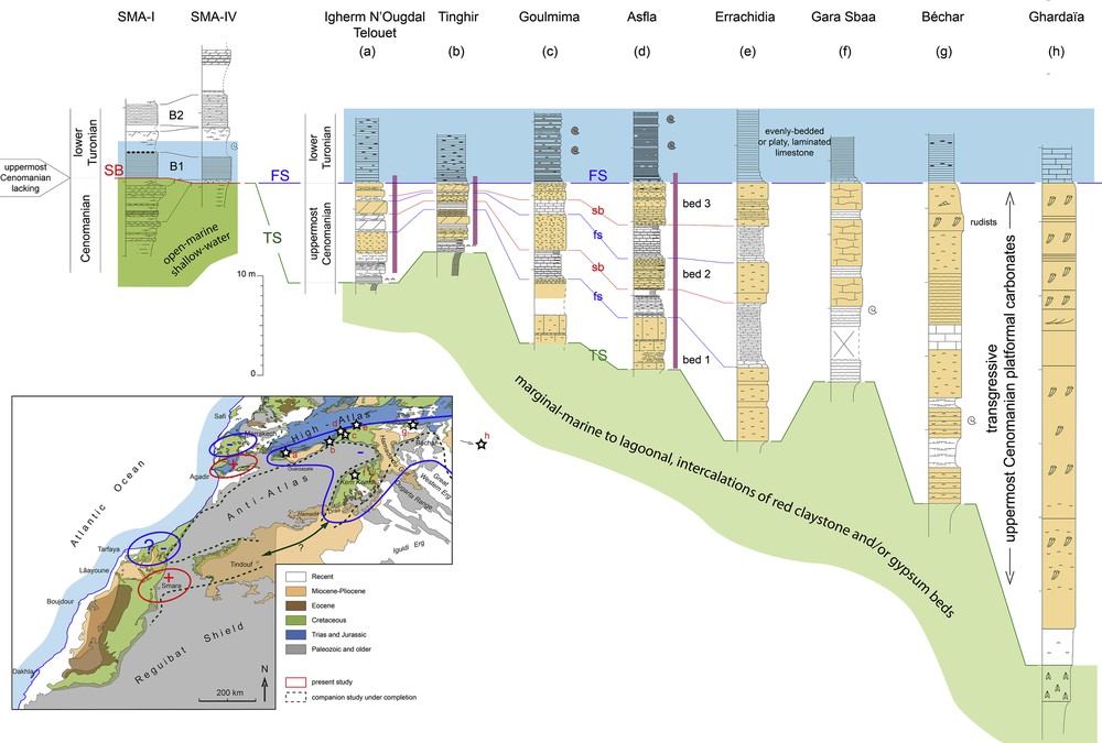
Correlation of sections covering the C–T transition along the edge of the Saharan Platform from South Morocco to western Algeria, and interpretation of relative sea-level changes in terms of subsidence/uplift (see map). Sections (a) to (d) are from unpublished data, with orange background indicating shallow-water, coquina-bearing (including rudists) limestones. Ammonites mostly after Meister et al., 2017. Section (e) is redrawn from Lezin et al. (2012), (f) from Cavin et al., 2010, (g) from Benyoucef and Meister, 2015, (h) from Nouh-Mefnoune (2006). The red-lined areas on the map are areas where an emergence fully covers the C–T transition or part of it. Blue-lined are areas, where the C–T transition is within a full transgressive trend. Vertical violin bars, stratigraphic extent of the δ13C shift of the Cenomanian–Turonian Boundary Event (work in progress). Stratigraphic surfaces (upper case major, lower case minor): SB, sequence boundary; TS, transgression surface; FS, flooding surface.
What occurred just before this peak transgression, that is during the latest Cenomanian CTBE/OAE2 event, is more complicated, and despite what has been suggested above in the Smara area about a large Cenomanian transgression followed by a stronger Turonian one. The correlation scheme (Fig. 5) is based on the tracking of short-term depositional sequences with the help of the CTBE δ13C isotope signal (work in progress) within the C–T boundary deposits along the southern border of the Atlas belt. As well as in the Saharan lagoon (Busson et al., 1999; Grosheny et al., 2013), the southern shoulder of the Atlasic rift experienced a latest Cenomanian transgression represented (Fig. 5) by two or three short-term shallow-water carbonate sequences exactly spanning the CTBE δ13C shift. This transgressive pulse is recorded along the Saharan Atlas up to Tunisia (Grosheny et al., 2013; Bachari et al., 2019), and therefore is opposed to what is found along some segments of the Atlantic margin. In the Smara area (Fig. 2), an exposure coupled with truncation of upper Cenomanian sequences is recorded instead, as explained above. The same sequence stratigraphic disturbance was also found along the southwestern shoulder of the Atlasic rift (uplifted area, Fig. 5), in the Agadir basin (Jati et al., 2010), although a coeval deepening (subsiding area, Fig. 5) is found to the north in the Essaouira basin (work in progress). The areas that underwent either a deepening or an uplift from the sedimentary record are shown in Fig. 4. Evidences of local uplifts are along the Atlantic margin, in opposition to the remaining of the African craton to the east, which subsided during the CTBE. Other evidences are found along the Iberian and French Atlantic margin (as discussed in Grosheny et al., 2017b). On the Atlantic margin of France for instance, Desmares et al. (in press) showed that the CTBE beds are lacking on the eastern termination of the Armorican Massif, while they are present in the Paris Basin to the east, and also on the coastal section of Charentes to the west (refs. in Lasseur et al., 2008). This suggests that the massif underwent an uplift just before the early Turonian transgression. We think that the same might have occurred on the western part of the Smara area, which would explain the hiatus found in the SMA-IV section (Fig. 2). Allocyclic processes are excluded, given the very good lateral continuity of metre-scale sequences in the area. The hiatus is therefore explained by the truncation of the sedimentary succession by the wave ravinement surface of the early Turonian transgression on an area that was uplifted during the CTBE event.
Grosheny et al. (2017a) suggested that such sequence stratigraphic heterogeneity was the result of the short-lived tendency to tectonic inversion of the Atlantic margin during the CTBE event, as a result of an hypothesized tectonic pulse recorded on a larger scale. All available stratigraphic data suggesting basement deformations during the CTBE along the South Moroccan Atlantic margin are in Fig. 5 (lower box).
Although considered a passive margin, the Moroccan Atlantic margin underwent some major uplifts during its Mesozoic to Cenozoic history (Benabdellouahed et al., 2017; Bertotti and Gouiza, 2012; Gouiza et al., 2010; Leprêtre et al., 2017, 2018; Meghraoui et al., 1998; Westaway et al., 2009). The short-lived uplift inferred here around the C–T boundary could be part of this complex history involving subsidence interrupted by uplifts. What the present study suggests is that such uplifts may have been very short in duration, based on the stratigraphic record.
4.4 Turonian to Coniacian sequences
The upper Turonian to (?) Coniacian T–R sequences (Fig. 2) have a special pattern. In some cases, the flooding marlstone of a sequence is sharply truncated by the beach facies of the regressive half-cycle or by the bioturbated transgressive sandstone bed of the overlying sequence. In some case, the nesting of successive beach prisms (Fig. 2) is indicative of stepped forced regression. In lower Albian short-term sequences (Fig. 3), small incised valley fills indicative of forced regression may even be found between the highstand marlstone of a given sequence and the transgressive sandstone of the next sequence. Such unusual patterns are commonly found on very low-sloped ramp profiles, where the slightest sea-level drop can be marked by sharp facies changes. In the Cenomanian of the western High-Atlas, Essafraoui et al. (2015) developed a sequence stratigraphic model for such deposits, including the occurrence of regressive fluvial deposits above a continental aggradation surface. The latter are not present in the Laâyoune basin, but the observed patterns of Late Cretaceous sequences indicate a very low-sloped depositional profile, responsible of the evidences of stepped regression during the regressive half-cycle of depositional sequences.
5 Conclusions
In the onshore part of the Smara–Lâayoune sub-basin, the Cretaceous marine transgression began presumably in the early Albian. It proceeded by successive steps to onlap the Palaeozoic basement in the Cenomanian, to reach a maximum in the early Turonian. At that time, the Anti-Atlas massif may have been an island, isolated from the Reguibat Shield by a narrow seaway connecting the Atlantic, the Tethys and the Saharan lagoon through the Smara–Kem Kem embayments. The Cenomanian–Turonian boundary is marked here by a short-lived emergence, as on the western termination of the Atlas belt (Agadir area), contrarily to what is more commonly found elsewhere (flooding). The whole sedimentary data, including the southern shoulder of the Atlas rift under study, point to a brief tectonic uplift (? inversion) of the Atlantic side of the Anti-Atlas and the Reguibat Shield during the Cenomanian–Turonian Boundary Event.
Acknowledgements
This paper is a contribution to the Cooperative Programme between the Universities of Lorraine (France) and Agadir (Morocco) – Programme Hubert-Curien Volubilis (Grant MA/14/305) -, and part of the ongoing PhD work of the first author.
The careful reading and sound comments of an anonymous reviewer helped to improve the manuscript, although all the recommendations could not be met due to the short format of C. R. Geoscience articles.