


 CC-BY 4.0
1. Introduction
In the early 2000s, advances in reconnaissance and offshore work made it possible to consider tapping water from submarine springs to offset the decreasing availability of water in coastal regions where development projects and new population settlements were flourishing. Specialized companies sought to develop devices to capture this unconventional resource. In 1999, on a television program, an underwater contractor had just conducted an experiment to try to show that the capture of water emerging from a submarine spring was feasible. The spectacular demonstration consisted of placing an “umbrella” over the Mortola spring located in Italy, close to the French border, at 36 m below sea level (bsl). The entrepreneur, founder of a French company dedicated to this objective, turned to G. de Marsily, who was associated with studies on karstic springs of Mediterranean coastal aquifers [Arfib et al. 2002, Arfib and de Marsily 2004], in order to obtain scientific and technical support for the understanding of hydrogeology and thus ensure the success of his project.
Since the 1960s, local studies have focused on some of the most spectacular coastal or submarine springs [Kuscer and Kuscer 1962, Moulard et al. 1965], sometimes with a view to exploiting the resource. The best example is that of the Port-Miou spring (calanque of Cassis, close to Marseille, South of France), on which the Société des Eaux de Marseille had undertaken studies and work to try to lower the salinity of its water with a view to using it [for a synthesis, see Tardieu and Potié 2015]. The submarine outlet of this large karstic conduit, emerging 12 m bsl at the bottom of the Port-Miou cove has long been known. It was formally identified by de Marsigli [1725] in the early 18th century. Considered as the precursor of oceanography [Toulmond 2006], de Marsigli associated this important and continuous discharge of underground fresh water to a conduit draining the Provence hinterland; but above all, he was able to bring this phenomenon closer to what he had previously observed in Lika, where karstic plateaus are the origin of submarine discharge of fresh water along the Croatian coast of the Adriatic Sea.
It was not possible to respond to the request of the company without addressing questions that had not yet been resolved by these dispersed studies. In particular, it appeared necessary to characterize these submarine outlets and to improve the understanding of the functioning and structure inherited from eustatic variations of the aquifers feeding these unconventional discharges, in order to build a typology of the springs, with a view to their eventual capture. In addition, an exhaustive inventory of existing knowledge and data was essential to serve as a basis for a market study and commercial prospecting with a view to establishing these catchments [Fleury 2005, Fleury et al. 2007a, 2008].
The development of a prototype (Figure 1) to capture the Mortola spring, near Menton [Fleury et al. 2007b] showed the difficulties of production, due mainly to two factors which are very difficult to control: the evaluation of the flow at the spring, and the sealing of the device. They are both dependent on the karstic nature of the spring and its aquifer, favoring a certain variability of the flow and the existence of leaks linked to the karstic conduit system. Subsequent studies have confirmed that this problem of saline intrusion is inherent to the karstic nature of the reservoir characterized by conduits and fractures connected to the marine environment, sometimes at great depth.
Ghislain de Marsily in front of the prototype of the catchment device of the Mortola spring, before its installation, in the port of Menton, France, in 2003 (Photo by M. Bakalowicz).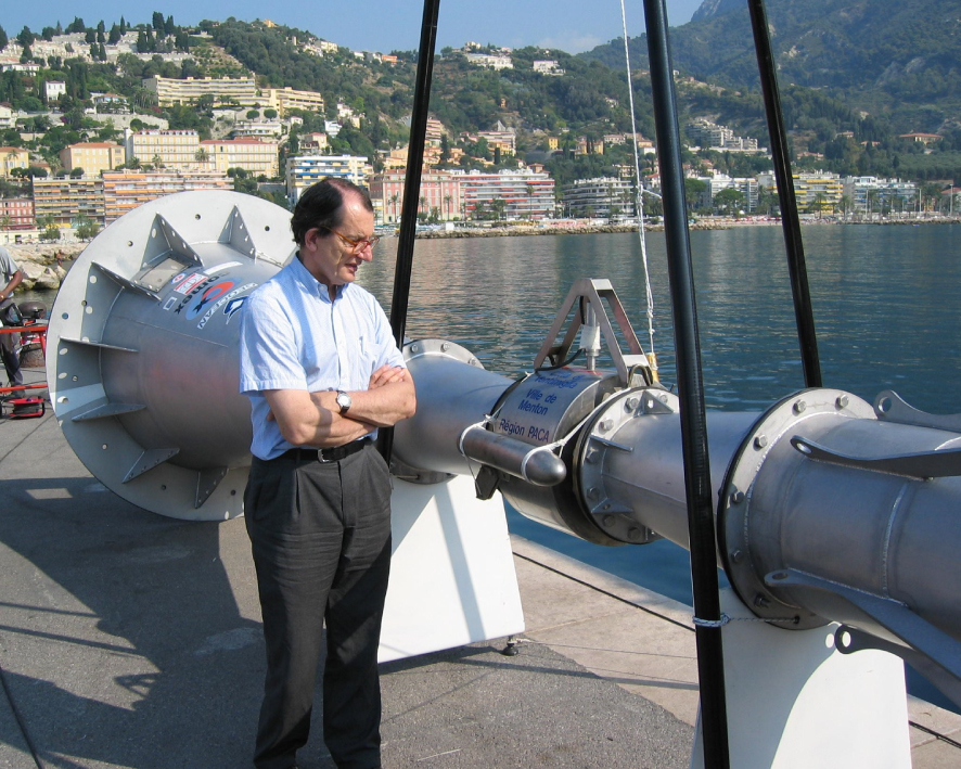
The global inventory of submarine springs [Fleury 2005] highlighted several key points:
- Submarine springs are a very special case of Submarine Groundwater Discharge [SGD, Zektser et al. 1983], since they are localized, concentrated, fresh or brackish water sources; they are therefore associated with a specific morphological and biological environment. Hence, they could be relevant water supplies.
- The vast majority are associated with karst aquifers. The rest are linked to highly fractured volcanic aquifers.
- Most of the known springs are located in the Mediterranean basin, related to Jurassic and Cretaceous limestone in large areas (Figure 2).
These primary works allowed the establishment of collaborations that led to a European project for the study of non-conventional water resources, mainly those of the Mediterranean coastal karst aquifers (MEDITATE project, 2004–2007, https://cordis.europa.eu/project/id/509112). Sites in Turkey, Syria and Lebanon, identified as corresponding to submarine springs of great interest for supplying population needs, have been studied by different complementary approaches.
Map of karst areas around the Mediterranean, taken from WOKAM map [Goldscheider et al. 2020] with the location of the main known karst submarine springs with red dots [adapted from Fleury 2005]. The three main remaining hypersaline basins at the Messinian low stage are shown in pink with the main post-Messinian fluvial fans in grey (adapted from the maps from https://fr.wikipedia.org/wiki/Crise˙de˙salinit%C3%A9˙messinienne). The main coastal and submarine springs cited in the text are represented with larger red dots: A: Mortola, France; B: Port-Miou, France; C: Almyros of Heraklion, Crete, Greece; D: Fontaine de Vaucluse, France; E: Gulf of Bassieh, Syria; F: Gulf of Chekka, Lebanon; G: Fontestramar, France.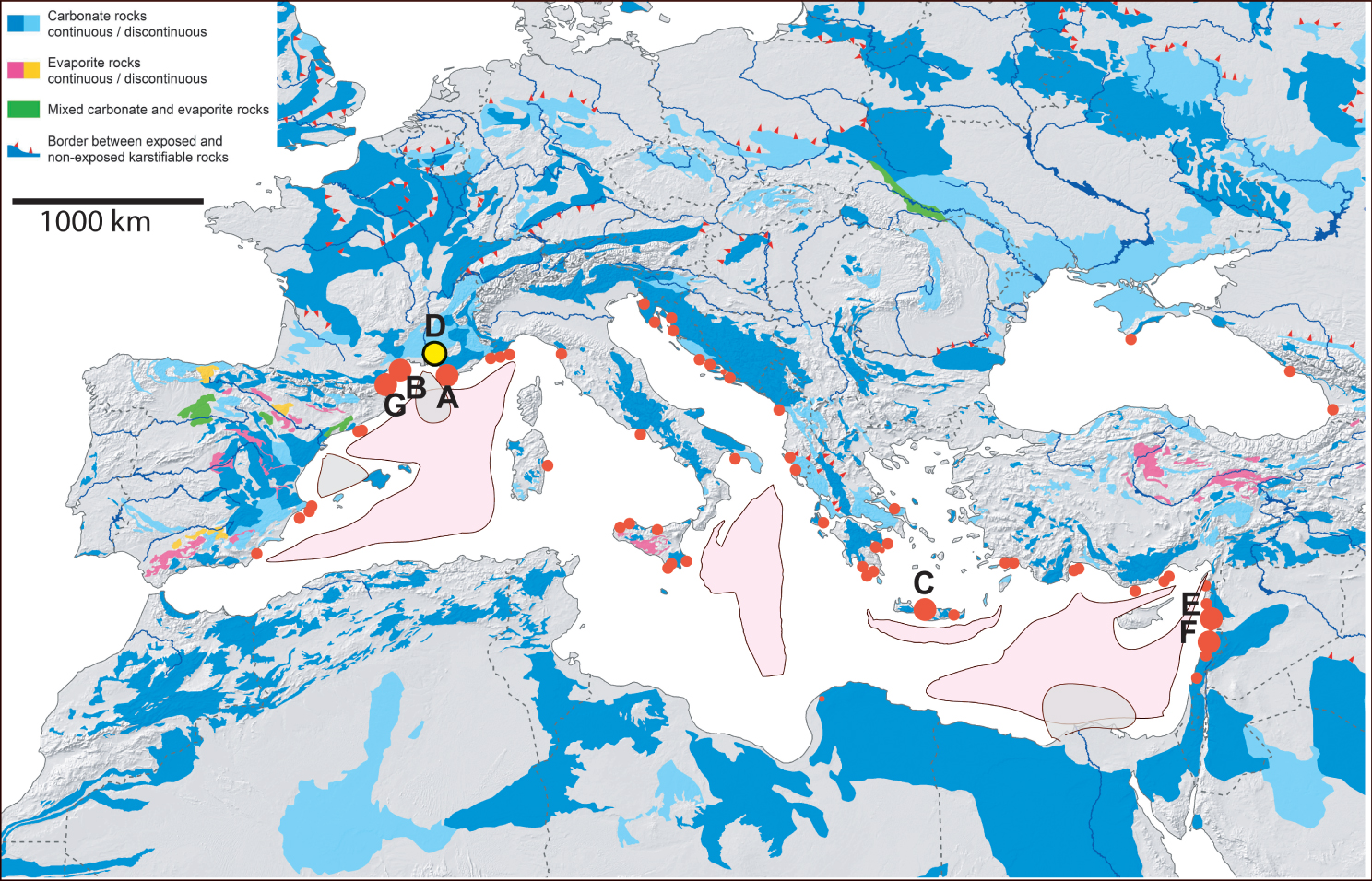
In this paper, the main contributions of these investigations will be summarized. We will then show the bottlenecks that make these littoral karst aquifers still very difficult, if not impossible, to exploit in the framework of an integrated regional management. Finally, we will share our thoughts on the future of these resources in the face of the challenges posed by climate change and population growth in these regions.
2. Main results
The comprehensive bibliography carried out on submarine springs, as well as on many coastal springs, and Mediterranean coastal karsts [Fleury 2005, Fleury et al. 2007a] revealed that groundwater from all these outlets is brackish, for at least a part of the year, and therefore unfit for drinking water. Originally, either a very local marine intrusion into the conduit or a leaching of saline formations into the aquifer was invoked. The “inversac” phenomenon was first described and interpreted by de Serres [1849], and then by Gèze [1938], in a channel between the Ambressac coastal karstic spring and the marine lagoon of Thau, near Montpellier, South of France. He described two inverse currents driven by the difference in density, one of fresh water at the surface towards the sea, the other at the bottom towards the spring, interpreted as an intrusion of marine water into the aquifer. Inversacs are well documented also at the La Vise submarine spring, in the Thau lagoon, near Montpellier, France [Ladouche et al. 2018]. This is a mechanism typical of conduit flow, particularly sensitive to fluctuating water head relationships, between fluids of different density.
The same phenomenon of flow stratification driven by density difference occurs inside the main conduit at Port-Miou, where initial work led to the building of a partial dam in the bottom of the karst conduit to prevent intrusion of the incoming marine water flow, in order to be able to capture freshwater [Tardieu and Potié 2015]. This construction allowed the interruption of direct seawater intrusion through the base of the conduit.
Unfortunately, salinity only decreased slightly, showing that most of the salinization does not come from this localized conduit, but probably from a more diffuse intrusion in the aquifer at depth. Chemical and isotopic analyses ruled out contamination by dissolution of gypsum–salt formations, such as those in the Triassic [Blavoux et al. 2004]. More recent studies on the Almyros of Heraklion (Crete, Greece) concluded to a marine intrusion in the aquifer at around 600 m bsl [Arfib and de Marsily 2004]. The intrusion was supposed to occur through a conduit-matrix system, implying the existence of karst conduits at a depth incompatible with the lowering of the sea level during Quaternary glaciations (120 to 140 m bsl).
Only the development of karst features at depth due to a considerable lowering of the sea level can account for both the remarkable occurrence of karst submarine springs (KSMS), brackish coastal springs along the Mediterranean coast and the salinization of carbonate aquifers by marine intrusion at great depth. The Messinian Salinity Crisis [MCS, −7.2 to −5.3 Ma; Rouchy and Saint-Martin 1992, Rouchy et al. 2006] is the major geological event that explains this situation [Fleury et al. 2007b]. With a maximum lowering of the sea level from 1500 to 2500 m during a few hundred thousand years, the valleys of the main rivers were deepened to reach the new sea level, in a few residual basins (Figure 2). At the same time, karstification was able to develop in all the carbonate massifs of the basin.
Numerous cave diving explorations have been carried out in recent years in flooded karstic conduits connected to the outlets (Fontestramar and Port-Miou, South of France). Particularly impressive and perilous, they have reached record depths (286 m bsl reached by X. Méniscus in 2015 at Fontestramar, https://o-dive.com/record-du-monde-pour-xavier-meniscus/). The objective of these surveys was to map the coastal karst network in order to identify the conduits responsible for the salt intrusion and eventually consider their closure. Given the complexity and the multitude of karst voids, some large ones connected to the sea which induces both diffuse and localized saline intrusion, these experiments are unfortunately doomed to failure.
The research conducted in particular within the framework of the MEDITATE project on different types of Mediterranean coastal karst systems has made it possible to propose a typology, serving as a basis for a specific strategy of exploitation and protection of the groundwater resource [Bakalowicz 2018]. Karst systems located along the Mediterranean coastline during the MCS appear to be unique among karst areas of the world. Huge conduit systems developed in a relatively short geological time, in carbonate formations, several hundred to several thousand meters thick. They developed over large recharge areas, extending to all coastal carbonate massifs. They ceased to function abruptly as a result of the Zanclean sea level rise (5.33 Ma). At many places mainly related to river valleys, sedimentation of marine blue clays occurred, covered by Pliocene delta sediments. The Zanclean transgression created two main hydrogeological situations of post-Messinian karst systems (Figure 3).
The two main types of post-Messinian coastal karst systems in the Mediterranean basin. (a) Plugged, and (b) unplugged.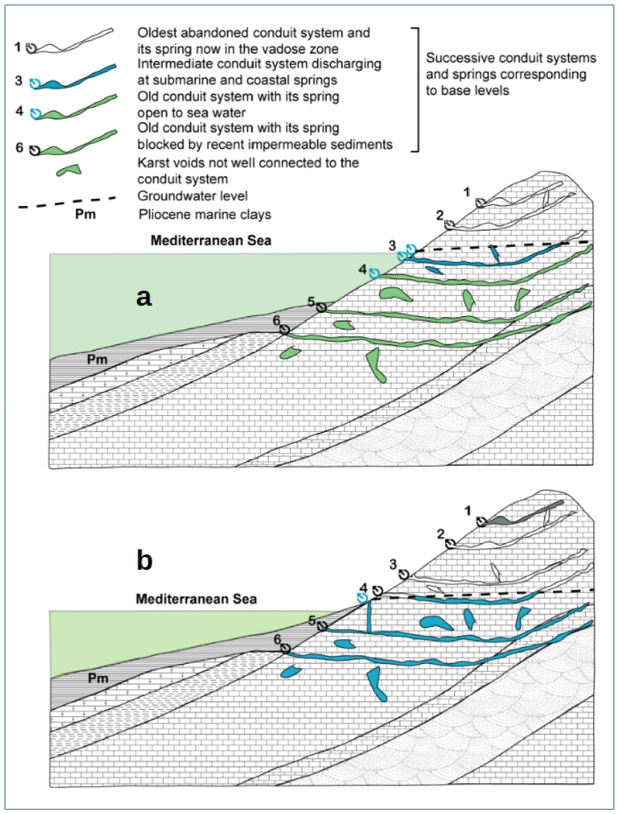
2.1. Plugged karst systems
The systems that discharged into the main valleys during the MSC became plugged with marine clays during the Zanclean transgression (Figure 3a). They were totally filled up with fresh groundwater which discharged generally at the summit of Pliocene formations. Their characteristics can be compared to those of basins and grabens, i.e., a large extent that provides abundant resources and a large storage capacity [El Hakim and Bakalowicz 2007]. In the lower Rhone River valley, France, Fontaine de Vaucluse is a typical example of these post-Messinian karst systems. These are the Vaucluse-type springs, overflow of the phreatic zone after the plugging of the original springs. However, their conduit systems are typically too deep to be intersected by wells, except sometimes near the spring as in the case of the Lez spring, France [Maréchal et al. 2013].
In some cases, marine clays or other formations such as basalts may have plugged coastal aquifers, thus confining groundwater and preventing seawater intrusion. This is the situation at the El Sin spring and Banyias karst aquifer in the Gulf of Bassieh, Syria [Abou Zakhem and Hafez 2007], and at the Gradole, and Jadro springs, Croatia [Mijatovic 2007]. These aquifers are exploited for water supply thanks to wells placed 100 m from the sea shore at Banyias, or pumping stations at the springs in Croatia. These karst systems are the most suitable for active management, using the significant reserves as a buffer to allow pumping of the groundwater at rates close to their mean discharge during the low-flow season, as is done at the Lez spring [Maréchal et al. 2013].
2.2. Unplugged coastal karst systems
However, most carbonate formations along the coasts were either not covered with sediments or the sediments may have eroded after MSC. Consequently, surface karst features such as sinkholes which are now flooded are generally connected to conduit systems that still function inland in the recharge area (Figure 3b). Because of their karstic characteristics, most unplugged system KSMS are subject to seasonal variations of flow rate and quality. As long as the fresh-water head in the conduits is higher than the seawater head, the karst systems discharge at submarine and coastal springs corresponding to these flooded karst features. Numerous coastal and submarine springs are known along the Mediterranean coast. During periods of drying up, the piezometric level decreases. At the freshwater–saltwater interface, due to density differences, a reversal of the hydraulic gradient can occur. Groundwater head may be lower than the seawater head (Figure 4, green domain). The conduits may then swallow seawater which salinizes groundwater at least into the conduits, up to KSMS and even to coastal springs which then discharge brackish water. The salinity varies according to (1) the sea level, and (2) the fresh groundwater level in the conduit system, as shown by the data from the Chekka karst system, Lebanon [El-Hajj 2008, Bakalowicz and El-Hajj 2012], the best documented example to this day (Figure 5).
Sea-water vs fresh groundwater in coastal aquifers. Diagram showing the depth below sea level at which a KSMS may discharge, depending on the fresh water head in the conduit discharging at the spring. The blue zone is the most frequent domain of submarine springs discharging fresh or brackish groundwater. The green zone is the domain of common sea water inflow in coastal aquifers, through karst flooded features.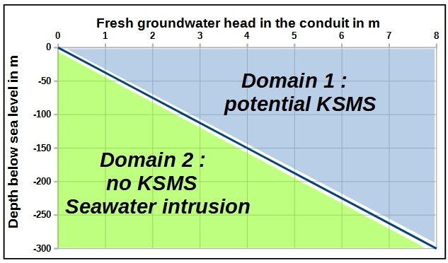
Scheme illustrating the functioning of the Chekka coastal discharge system, on a cross section along the Nahr el Asfour River paleo-valley, North Lebanon [modified from El-Hajj 2008]. The deepest flooded karst features swallow seawater during the low flow stage. The permanent spring S2 discharges brackish water. Blue arrows: fresh water flow; green arrows: seawater flow; blue green arrows: brackish water.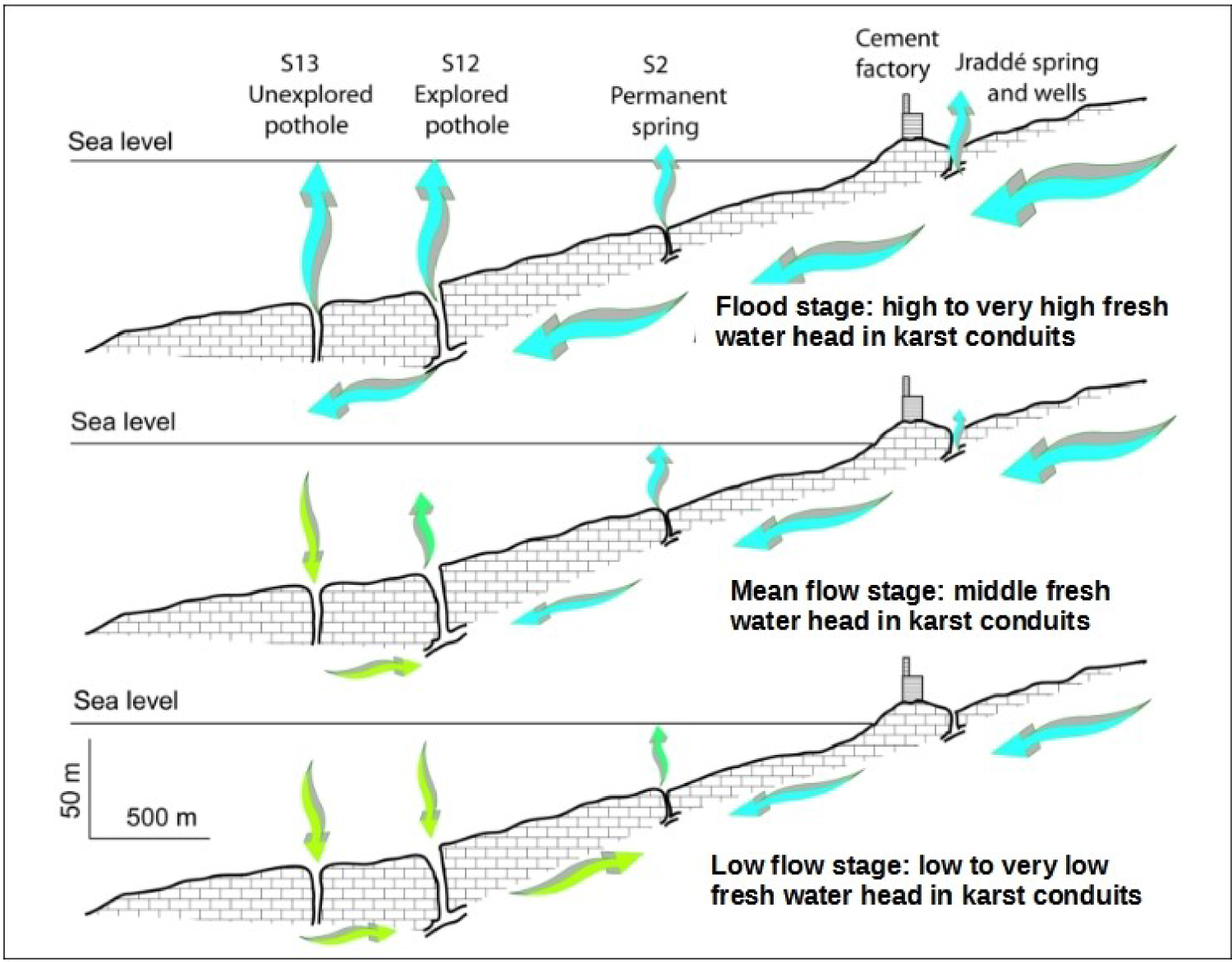
3. Technical and scientific obstacles
The first main questioning is related to the assessment of their flow rate and seasonal variations. The economic value of capturing a KSMS mainly depends on the potentially exploited volume of water and its quality. Various authors have used different methods to assess it, including stable isotopes, remote sensing and visual estimates from the dimension of the mark at the sea surface. Generally, it is almost impossible to make a direct and continuous flow measurement, except during low stage for systems with a unique spring. The specific layout of the Port-Miou spring made the monitoring of the salinity and the flow rate inside the conduit relatively easy, which was around 1.5 m3/s at the beginning of the low flow stage, following the last recharge [April to May 2006; Arfib and Douchet 2011, Cavalera 2007].
Direct measurements by means of flow meters in pipes catching the output discharge were performed at the Mortola and Chekka KSMS at several times. Indirect assessments were attempted by delineating the recharge area, i.e., the extension of the karst system from geology and tracing tests, and the calculation of the annual water balance, the input flow at swallow holes. Both methods show that previous estimates of instantaneous as well as mean annual discharges were exaggerated by 5 to 10 times in the few studied cases. This overestimation is related to the acceleration of the flow of water from the aquifer when it reaches the marine environment due to the difference in density. This phenomenon creates a narrow column of fresh or brackish water, whose velocity is driven by the difference of density with seawater, not at all by the natural flow at the outlet. The divers roughly assessed the discharge from either the flow velocity above the spring or even from the extent of the surface anomaly created by the upwards flow.
Modeling of the plume above the spring has been attempted to analyze flows, including return currents carrying sediment to the bottom [Buongiorno Nardelli et al. 2017]. These could be used to estimate flow from accurate in-situ measurements. A Submarine Underwater Vehicle had been developed to explore these plumes and to determine all the parameters needed for such modeling [Bakalowicz et al. 2003a, b]; however, the project was not completed.
Several KSMS may have a mean annual discharge of several m3/s which makes them interesting potential water resources in coastal areas that often lack water. However, their hydrological functioning is typically karstic, characterized by strong seasonal, even daily, variations of discharge and water quality, as occurs at Chekka Bay submarine springs, Lebanon [El-Hajj 2008]. The recharge area of the Chekka karst system covers about 250 km2 of North Lebanon. Its main KSMS discharges at 23 m bsl 0.1 m3/s during low flow stage, of brackish water at 35% of seawater, decreasing to 0.030 m3/s at 50 to 80% of seawater at the end of the dry season, while the first estimate suggested 2 m3/s of fresh water [Moulard et al. 1965]. During winter floods, the system discharges at several KSMS, with the most important being found at 110 m bsl The water balance gives an average of 2.15 m3/s, with a high reliability as the hydrogeological catchment is well controlled, while Moulard et al. [1965] estimated it to be at least 25 m3/s.
Several tools are presently very efficient for identifying SGD from coastal kart aquifers [Jou-Claus et al. 2021, Schubert et al. 2014]. Despite there being no reliable method for assessing their discharge and consequently their actual groundwater resource, especially in the Mediterranean basin, some risky estimation claims that “Submarine groundwater discharge can dominate inflows in restricted seas or embayments. For example, karst comprises 60% of the shoreline of the Mediterranean and is estimated to contribute 75% of its freshwater input – much of this input must be via SGD.” [UNESCO 2004]. However, in the same publication [UNESCO 2004, p. 19], the authors write that: “Recent attempts to quantify the amount of total underground fluid flow into Florida Bay Submarine groundwater discharge by modeling vary by 3–4 orders of magnitude!”.
Fresh groundwater discharge from coastal karst aquifers can also be calculated directly in water budgets. Bayari et al. [2011] estimated from water balance that the coastal karst aquifers of the southwestern Mediterranean coast of Turkey should discharge an average of about 360 L/s per km of carbonate shoreline,120 km long. The data collected by the WOKAM project [Goldscheider et al. 2020] should allow an assessment of much better reliability.
In all these unplugged coastal karst systems, the conduits are open to the sea at different depths, which makes easy natural localized seawater intrusion, especially during the low flow stage. All submarine and many coastal springs discharge brackish water, at least during the dry season. It was shown that seawater intrusion may occur some hundred meters below sea level [Arfib and Douchet 2011, Bakalowicz and El-Hajj 2012].
Various tests have been done to capture submarine springs using, for instance, particular bells to cover the outlet as it was done by Stefanon [1972] in the Gulf of Taranto, Italy. The system that drives fresh or brackish water to the sea surface reduces the water head over the spring, which increases the seawater head in the conduit, enhances seawater intrusion, and raises the salinity of the captured water. Capturing “fresh” water from karst submarine springs thus appears to be an impossible challenge. As a result, these submarine springs are not exploitable, not only because of the low discharge during the dry season but also because of brackish water. Brackish water can be desalinated [Ahdab and Lienhard 2021, Breznik and Steinman 2011] for supply water, which consumes less energy than desalinating seawater. However, the process implies that the salinity should be stable, a condition which is not fulfilled at KSMS. Therefore, it seems much better to tap groundwater from inland wells, and monitor salinity and flow at submarine springs, wells or coastal springs for reducing seawater intrusion and preventing it by reducing pumping rates in wells [Bakalowicz 2018]. KSMS then should be considered as interesting tools for groundwater resources management in coastal areas.
4. Biodiversity and exchanges between sea and groundwater from karst aquifers
The investigations of nutrient inputs to the ocean from continental waters, including SGD [Santos et al. 2021], have been conducted for about 20 years to assess their contribution to marine biodiversity. The concentrated discharge of karst ground water from submarine springs is obviously being investigated [Bejannin et al. 2020, Tamborski et al. 2020]. It is considered negligible in quantity, but important in quality [Luijendijk et al. 2020]. However, the volumes of freshwater discharged directly to the sea are incomparably smaller than those from rivers, such as the Nile, the Rhone and the Po Rivers. In addition, most of the Mediterranean KSMS is subject to a very high seasonal variability of flow associated with that of their salinity: on the whole, the high flows of the rainy season and snowmelt (October to April) bring fresh water, rather rich in nutrients of continental origin, into a sea agitated by storms, while the rest of the year the waters are rather brackish, with a low land contribution. Thus, a limited overall contribution to marine biodiversity is to be expected. Reliable data are still lacking relating nutrients and fauna richness around these underwater sources.
In fact, from a biodiversity standpoint, the input of seawater into coastal karst aquifers likely has a major impact on biodiversity. But it seems that the part played by the MCS is not yet fully considered by scientists. For a long time, the hydrobiologists have shown [Rouch and Danielopol 1987] that the underground aquatic fauna has its origin in the surface fauna, which takes refuge in the aquifers or colonizes them. Studies showed that in France at least, the large Mediterranean karstic aquifers contain an abundant, diversified and originally hypogean aquatic fauna, compared with those of other regions [Deharveng et al. 2009]. Thus, one aspect of the impact of MCS on Mediterranean coastal karst aquifers, currently ignored, is that of the introduction of marine species into the aquifers during the Zanclean transgression (5.3 Ma). Moreover, since this major abrupt event [Lofi et al. 2005], all unplugged karst systems are subjected to permanent exchanges of marine water and fauna, which allow an active colonization of the subsurface environment by epigeous organisms. This is a research field that deserves to be developed, in order to give responses to fundamental questions about adaptation and evolution in fresh groundwater [Mammola et al. 2020].
5. Global changes and coastal karst aquifers
Unlike porous and fissured aquifers, the mechanism of marine intrusion in karst aquifers cannot be described spatially by a simple physical law. Indeed, the existence of drainage structures inherited from a long and complex geological history creates a heterogeneity of groundwater flows such that seawater can naturally penetrate the aquifer very deep inland. As shown by the phenomenon of inversac and the salinization of the aquifer, the coastal karst aquifers, with their conduits open to the sea at variable depths, put into a very fragile equilibrium relationship the fresh water flowing from the continent and the marine water that repels it by density effect. This fragile equilibrium is prone to a natural decrease of the freshwater head, due to the reduction of groundwater recharge, consequence of a reduction of the effective rainfall and/or of soil sealing, and to the increase of the marine water head by the rise of the sea level. In addition, anthropogenic forcing, of which pumping is the main factor, obviously enhances considerably the natural effects. The following examples can give an idea of the seawater intrusion issue in karstic aquifers.
The Burren karst in Ireland, subject to low anthropogenic forcing, has been studied to characterize the hydrodynamic functioning of a karst aquifer in relation to seawater movement [Perriquet et al. 2014]. The salinity and groundwater levels were measured in boreholes and also directly in the phreatic zone to assess the extent of the intrusion of the seawater wedge into the aquifer as a function of both karst recharge and tidal movements. The marked spatial disparity of the seawater wedge was analyzed as a function of both the hydrodynamic and the structural properties of the karst aquifer. Results showed that the extent of the seawater wedge depends not only on the intrinsic properties of the aquifer, but also on the relative influence of recharge and tide effects on groundwater levels, which are opposite. Recharge in the Burren region throughout the year is sufficiently high to prevent seawater intrusion more than about one kilometer from the shoreline. A strong tidal amplitude appears to drive the sudden seawater intrusion observed in the nearshore aquifer, while the position of the groundwater level appears to influence the intensity of the increase in salinity.
This study highlights the importance of monitoring for characterizing the salinization phenomenon in coastal karst aquifers. The same approach was applied at two coastal karsts in the south of France: the karst aquifer of Aumelas discharging into the Thau Lagoon [Pétré et al. 2020] and the Eastern Corbières aquifer, both located to the West of Montpellier. These aquifers are instrumented with salinity, temperature and groundwater level data loggers to assess the seawater intrusion, as part of a research project conducted by the French Geological Survey (BRGM). The outlets, namely the Vise submarine spring in the Thau lagoon, at 30 m bsl, and Fontestramar coastal spring, at +4 m above sea level (asl) are monitored, as well as boreholes and surface flow upstream swallow holes. The study on the Thau karst is currently ongoing.
Over the last 50 years, the Thau karst aquifer was subject to seven brackish water intrusions via the submarine spring of La Vise. These events, called inversac, took place in 1967, 1983, 1993, 2008, 2010, 2014 and 2021–2022 [Ladouche et al. 2018]. The last episode was particularly long, lasting 14 months. However, their duration varies from 1 month to almost a year and a half. Over the period from 1967 to 2007, only three inversacs occurred in 40 years, which represents a low decadal occurrence, while since 2008 four inversacs occurred in only 14 years. The frequency of occurrence increased significantly, related to an increase in groundwater pumping, associated with the increase in population and to irrigation, and probably also to an increase in drought periods linked to climate change.
The karst of the Eastern Corbières area offers an important groundwater resource, with an average flow of 2.5 m3/s, i.e., nearly 80 million m3/year, but the chloride concentration can reach 2.6 g/L, in a seasonal salinity range from 0.3 to 3.5 g/L [Dörfliger et al. 2008]. Furthermore, the episodes of intense rainfall seem to be intensifying. In this context, in catchments with a karst component, the understanding of the relationship between surface flows and karst aquifers is becoming essential, in order to be able to forecast floods and thus anticipate their effects.
Large-scale changes impacting groundwater resources were already observed around the Mediterranean. Thus, a regional study carried out in Morocco [Ahmed et al. 2021] has shown a drop in groundwater levels in several basins, which led to the disappearance of the water table in areas with shallow aquifers. One of the main factors is related to the change in agricultural practices from rain-fed to agriculture irrigated by groundwater. This sudden shift occurred at the expense of careful planning for the sustainability of groundwater resources. The consequential effects are an increasing risk of contamination by seawater intrusion, an increasing desertification, increasing costs of groundwater pumping and deterioration of ecosystems. These threats are expected to continue and even increase in the future if groundwater levels continue to decline. In order to counteract these threats, Morocco began to develop a policy to control groundwater extraction and use. This policy aims to promote efficient and economic use of groundwater resources, particularly in threatened aquifers, and to strengthen regulatory and institutional enforcement.
The assessment of the relative effects of climate change and anthropogenic forcing was also approached by coupling different model simulations under different climate change scenarios with hydrological models. This was done by Sivelle et al. [2021] on a Mediterranean karst system in the South of France. They coupled the results with scenarios of future groundwater extraction for drinking water supply (no abstraction, present-day abstraction, +50% abstraction and +100% abstraction at horizon 2100). They show that climate change will have the main effect; the extraction scenarios will be a secondary but non-negligible factor.
These regional resource management policies are developing around the world. Another example can be taken from an important karst aquifer in Florida. In this context, Silver Springs, a large karst spring system with an average flow rate of over 20 m3/s, draining the Floridan aquifer, was studied [Klammler et al. 2020]. The recharge area, approximately 2300 km2, is underlain by an aquifer system containing salt water at a depth of about 500 m, which is connected to the ocean through a permeable formation. It is located near the center line of the Florida peninsula, approximately 80 km from both the Atlantic and Gulf coasts. The recharge–storage–discharge dynamics of freshwater in this aquifer were characterized and a parsimonious model was developed. This work gives opportunity for regional and long-term management of groundwater resources.
The sudden modification of salinity conditions near the submarine springs and more widely in the coastal lagoons that they feed should lead to a modification and a rapid reduction of biodiversity with loss of species. Stenohaline or euryhaline organisms, for strictly halophilic organisms, are likely to disappear, with serious consequences for the fish farming and aquaculture activities linked to these lagoons, including socio-economic disturbances for the local populations, who are dependent on these activities [Rodriguez Estrella 2000]. Finally, saline intrusion far from the coast may affect the catchments for drinking water supply as well as those used for agricultural operations in the coastal areas [Romero Macias et al. 2000].
These complex coastal karst systems are characterized by a fragile state, very sensitive to seasonal variations in recharge, but also to sea level. In the context of climate change, an increase in the frequency and duration of drought periods is predicted, which will intensify seawater intrusion, due to the lowering of the hydraulic head in the conduits. Moreover, the sea level rise will magnify this effect, so that the quality of their groundwater will be deeply modified, at least in the parts closest to the coast.
It is clear that, because of their extreme sensitivity to variations in the equilibrium of heads between fresh groundwater and seawater, coastal karst aquifers play a watchdog role, likely to alert very quickly to unfavorable evolutions of the groundwater resource due to overexploitation and/or a decrease in recharge. Regular or early salinization during the year as well as the frequency of flow inversion, as in the case of the Vise spring, constitutes an alert concerning an unfavorable evolution of the groundwater resource. Under these conditions, coastal karst springs must be considered as observatories for monitoring coastal groundwater resources and saline intrusion. The implementation of coastal water resource observatories with monitoring of electrical conductivity is therefore becoming essential.
6. Summary
Coastal karst aquifers are beginning to be well identified on a global scale, by their location, their coastal and submarine springs and their general functioning. The vast majority are located in the Mediterranean basin, where their origin and their particular functioning are inherited from a major geological event, the Messinian salinity crisis (−7.2 to −5.3 Ma), responsible for the development of karst several hundred meters below the current sea level. Outside the Mediterranean basin, karst could only develop a few tens of meters below the current level, during the eustatic crises of the Quaternary.
Two types of coastal karst aquifers have been identified:
- those protected from marine intrusion by impermeable post-Messinian formations (marine blue clays, basalt), called “plugged karst systems”;
- those whose discharge zone, often including surface karst phenomena, now flooded, directly in contact with marine waters, called “unplugged karst systems”.
The second type of coastal karst aquifer, very common along the Mediterranean coast, is the origin of the numerous seasonal and permanent karst submarine springs (KSMS). These aquifers are very difficult to exploit, because the slightest variations in hydraulic head between fresh groundwater in the conduits and seawater facilitate natural saline intrusion, sometimes far from the coast, and at significant depths. This is why pumping operations require permanent observation of all recharge and withdrawal data, by setting up water head and salinity monitoring networks, possibly associated with artificial intelligence tools. Furthermore, direct tapping of these KSMS is not generally feasible, precisely because it contributes to modifying the delicate load balance between the sea and the karst conduits, thus facilitating the seawater intrusion. In any case, a good hydrogeological knowledge of these systems must precede the definition of the monitoring network and the management plan of these coastal aquifers.
The submarine discharge of coastal karst aquifers certainly impacts marine biodiversity by carrying nutrients and dissolved matter from the continent. But these impacts are limited compared to the much larger effects from rivers. However, the biodiversity of numerous lagoons fed by karst sources are largely modified and reduced in favor of halophilic species, but not well documented. In fact, the input of seawater into coastal karst aquifers likely has a major impact on groundwater biodiversity, by introducing marine species which then colonize aquifers, and adapt progressively to the constraints of subterranean conditions. The role of the MCS in the colonization of coastal karst aquifers would require careful attention.
Population movements towards the coasts create very strong pressures on these fragile resources, including increased groundwater withdrawals, to which will be added those related to climate change, such as the rise in sea level, the different seasonal distribution of rainfall and the increase in evapotranspiration. Coastal karst aquifers offer a freshwater resource that is certainly considerable, but needs to be evaluated, for the entire Mediterranean region. In order for them to really contribute to the maintenance of human activities in the best possible conditions, it becomes necessary, and even urgent, to study them in detail in order to protect them from uncontrolled intensive withdrawals, which could rapidly cause their general and irreversible salinization. The increase in groundwater withdrawals linked to the coastalisation of populations and activities, the reduction in aquifer recharge, and the rise in sea level will inevitably and rapidly have consequences on the salinization of coastal karst resources. Under these conditions, some karst systems will have to be abandoned and the water supply policy for coastal cities will have to be rethought.
Conflicts of interest
Authors have no conflict of interest to declare.
Acknowledgement
We are particularly grateful to Mrs Madeleine Wheatley who revised the English writing.