


 CC-BY 4.0
1. Introduction
The production of instrumental seismic bulletins is performed in different capacities by several seismological agencies working at local, regional and global scales. Among those providing seismic bulletins up to 1960s for worldwide earthquakes, the International Seismological Summary [ISS 1963–1963] and the Bureau Central de l’Association Internationale de Sismologie [BCIS 1933–1968] stand out as the most long-term and comprehensive ones. Rothé [1981] outlines historical details about the establishment of the BCIS in Strasbourg (France) and the ISS in the United Kingdom. Both ISS and BCIS usually list seismic event location parameters (e.g., origin time, epicentre and depth of earthquakes as well as other types of seismic sources such as rock bursts, nuclear explosions and so forth) and the associated arrival times of seismic waves gathered from stations worldwide. Examples of the content of ISS and BCIS for 1963 is shown in Figure 1. After the event parameter block, the ISS lists travel times whereas BCIS lists the absolute arrival times. This feature makes the BCIS station listing independent on the event origin time.
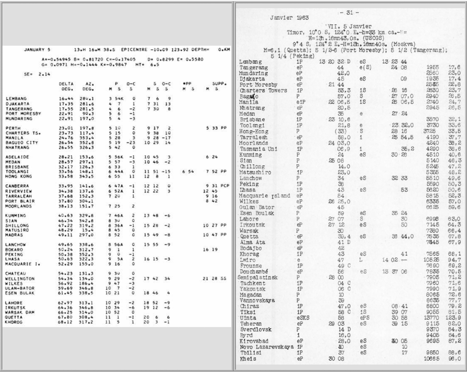
Example of ISS (left) and BCIS (right) content for an earthquake on the 5th of January 1963.
Recently, the ISS hypocentres [Villaseñor and Engdahl 2005] and associated data has been digitised after a significant undertaking over several years by various investigators [Engdahl and Villaseñor 2002, Di Giacomo et al. 2015b, 2018]. The results of such works provided earthquake parameters for about 25,000 earthquakes between 1918 and 1963 and approximately 2.8 M seismic wave arrival times from over 1000 stations. With regard to BCIS, however, apart from most of its hypocentres that have been digitised at different times by a number of investigators and included in an augmented version of the Centennial Catalog [Engdahl and Villaseñor 2002] as well as the Bulletin of the International Seismological Centre [ISC Bulletin, International Seismological Centre 2022b], the digitisation of the associated station data has not been pursued in a systematic way. Thousands of earthquakes in the 1950s and up to 1963 that are in the ISC database have no station data associated. This is summarised in Figure 2. Within the seismological community working in the pre-digital era [here intended as the instrumental period before the formal start of the rebuilt ISC Bulletin in 1964, Storchak et al. 2017, 2020], it is well-know that the BCIS is more complete than the ISS particularly in the years 1954–1963, when ISS significantly reduced their listings due to lack of resources. Therefore, the arrival times contained in the BCIS are possibly the most (if not the only) comprehensive collection of instrumental data for thousands of earthquakes in the 1950s-early 1960s that are not listed in the ISS.
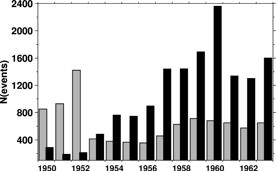
Number of seismic events per year in the ISS with station data associated (grey) and in the ISC database without station data at the time of writing (black, also referred to as targeted events in the text). In the latter we do not include earthquakes in the historical dataset of the Japanese Meteorological Agency (JMA) as the associated data is included in the ISC database.
There are several reasons to add station data in the pre-digital era:
- verification and validation of the occurrence of an earthquake or any seismic event. This is often an aspect of underestimated importance by groups working in catalogue compilations, particularly for earthquakes in the pre-digital era. Indeed, the event parameter digitisation from printed bulletins is at times affected by typos and inaccuracies in origin time and/or coordinates (e.g., wrong date or sign for latitude and longitude) that, if unchecked or unsupported by instrumental data, can remain for several years in catalogues and used for research. Examples in this respect are discussed by Di Giacomo and Dewey [2020] for the mythical Peru earthquake of 12 December 1908 and Okal and Langenhorst [2000] for the 11 July 1960 earthquake (origin time at 07:33:32). More cases in this sense will be summarised later;
- if enough data is available, we can perform earthquake relocations using modern techniques, magnitude reassessment and hence improve both the instrumental record and the picture of the seismicity of an area (as discussed in Section 4);
- we can improve the instrumental history of hundreds of seismic stations worldwide. This not only will preserve such unique instrumental data for future generations of seismologists (i.e., legacy purposes) but it is also a way to recognise the work done by thousands of station operators, analysts and seismologists over the decades in observatories worldwide.
With this contribution we report on a significant undertaking by the ISC to search and digitise the station data for all events in the BCIS 1950–1963 that have no instrumental record in the ISC database. After a brief description of the digitisation approach, we summarise and discuss the main features of the dataset so generated, point out some of the benefits to the Earth’s seismicity record and its importance for future activities.
2. Digitising BCIS arrival times
As previously mentioned, the digitisation of the station measurements in the BCIS bulletins is aimed only for those seismic events that have no associated measurements in the ISC database. With the latter we refer to a working account of the database that at the time of writing included the pre-1964 ISC Bulletin with the entire ISS content, hypocentres from an augmented version of the Centennial Catalogue [Engdahl and Villaseñor 2002] as well as the data of the Japanese Meteorological Agency (JMA) network since 1923 and other sources used for the production of the ISC-GEM Catalogue [Di Giacomo et al. 2015b, 2018]. In this context, we selected seismic events in the ISC database that have no associated data between 1950 and 1963 and searched for those events in the BCIS. Hereafter we refer to those as targeted events. We also looked in BCIS before 1950 but the bulk of the events without data in the ISS (but likely in BCIS) are mostly from the 1950s onward.
Our intention is to emulate to the highest extent possible the format of the BCIS printed bulletin (see Figure 1). In short, that is composed of the event information block and the station data listing: station name, onset, phase name, arrival time, polarity, and, if any, a second set of information for a second arrival. The last field at the end of the line is the distance as calculated at the time of the BCIS production. The digitisation process is performed in two steps: first, the station name list is created and used to match the station code in the International Seismograph Station Registry [IR, International Seismological Centre 2022a]. Once all stations are properly identified in the IR we calculate for each station (based on the station information in the IR) the theoretical arrival time of the first P-wave and the arrival time of the first S-wave truncated to the minute. The S-wave arrival truncation is due to the fact that for most stations only one P-wave arrival is available. At this point the manual revision takes place and the arrival times initially generated are edited to reproduce the arrival times in the BCIS as well as all other parameters (onset, phase, polarity). The distance (in km) at the end of each line is calculated using the ISC database prime location and the station coordinates in the IR and is used only for guidance whilst editing the file to help addressing inconsistencies in the listing (e.g., minute error, wrong station). Figure 3 shows an example of the file generated with predicted arrivals for an earthquake in January 1963 and its final version. With this approach the ISC data entry officer working on the file (see Acknowledgments) usually needs to check and (eventually) edit only onset, phase, minute-second of the first arrival time and complete the timestamp of the second arrival if available. Polarities and comments are also added. The initial truncation of the second arrivals reduces the amount of manual checks (if no second arrival is available there is no need for further editing), and incomplete arrival times will not be included in the ISC database.
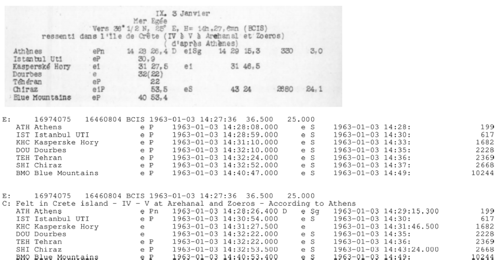
Example of a file generated for an earthquake in January 1963. On top it is shown the listing in the BCIS bulletin (original content can be viewed at page 19 of the PDF scan available at http://www.isc.ac.uk/printedStnBulletins/Bulletins_scans/France/Strasbourg/BCIS/BCIS_63A.pdf). In the middle it is shown the first step of the digitisation process and at the bottom its final version after manual editing. The second arrival times that have no complete timestamp (e.g., second arrival for stations IST, DOU, TEH, BMO in this example) will not be parsed in the ISC database and will removed from the files listed in the supplementary material of Di Giacomo [2022]. Note that we also added the comment in the second line and the IR code in front of the station name. On the event lines (i.e., starting with “E:”) there are two database identifiers: the event and prime hypocentre ids. The first serves to identify a physical event in our database, the second to identify the event prime hypocentre that is used to associate phase data to the event. Masquer
Example of a file generated for an earthquake in January 1963. On top it is shown the listing in the BCIS bulletin (original content can be viewed at page 19 of the PDF scan available at http://www.isc.ac.uk/printedStnBulletins/Bulletins_scans/France/Strasbourg/BCIS/BCIS_63A.pdf). In ... Lire la suite
After the file editing is completed, checks are run to verify its format integrity, the time residuals (i.e., difference between observed and calculated travel time) as well as onset, phase and polarity entries. If such checks return with errors and/or warnings about large residuals, the ISC data entry officer prompts an investigation to address the issue (e.g., typos, possible minute mark error, phase misidentification, wrong station and so forth). Null residuals are also rechecked to avoid having theoretical arrival times in the final version of the file. We will see in Section 3.2 that with such checks we have been able to rectify some errors in the starting location parameters. However, we cannot comment on the potential presence of any bias or trend in BCIS epicentres as we only limit to digitise phase data, whereas processing (relocation) is the subject of future activities (see Section 4).
Depending on the number of stations for an event the digitisation can take from 5 to over 15 min (usually for events with more than 40 stations). More time may be needed if any issue is found after running the checks (e.g., investigation about large residual warnings). On average, between 25 and 35 events per working day have been digitised by a single data entry officer.
3. Station data digitised for the targeted events in the ISC database
We began to digitise the BCIS content for the targeted events at the end of January 2020 and finished in July 2022 (with a few exceptions, the work has been carried out by one data entry officer at any given time). The events distribution and their annual counts are shown in Figure 4. The annual number of events listed in the BCIS for which we added data is much smaller for 1950–1952 compared to 1953–1963. As mentioned earlier, this corresponds to the years where ISS reduced their listings (see also Figure 2). In addition to the events with no data of Figure 2, we also looked for teleseismic data for the earthquakes in the Japanese archipelago having only data from the historical JMA network (i.e., data mostly from stations in the Japanese area, hence mostly recording at local and regional distances). As a result, from 1953 the annual event counts for which we added data from BCIS is marginally larger than the annual counts of the targeted events shown in Figure 2. There is an apparent dip in the annual count for years 1961–1963, which contradicts the increasing trend in annual counts between 1953 and 1960. This is also the case in Figure 2. We will address this feature in Section 3.1.
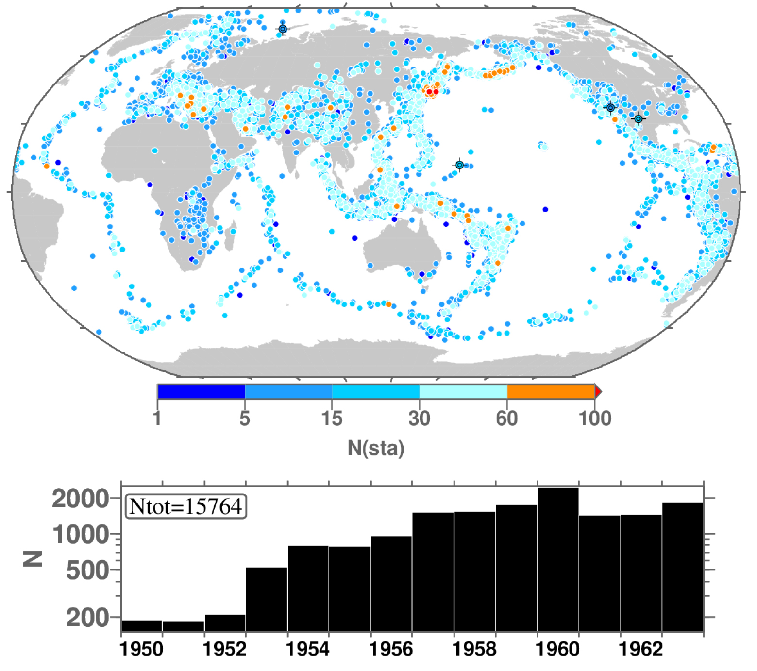
Map (top) of the distribution of the targeted events in the ISC database for which station data in the BCIS has been digitised (symbols colour-coded by number of stations) and the corresponding annual event counts (bottom). Events classified as nuclear explosions are shown with crosshair symbols.
Figure 5 shows the distribution of the stations in BCIS we digitised for the targeted events. Among the most recurrent stations reporting data for the targeted events there are College, Eureka, Hungry Horse, Tucson and Boulder City in North America (IR codes CMO, EUR, HHM, TUO and BCN, respectively), Kiruna, Uppsala and Stuttgart in Europe (IR codes KIR, UPP and STU, respectively) and outside those more densely instrumented areas we have in key positions stations such as Charters Towers and Brisbane in Australia (IR codes CTA and BRSB, respectively), Quetta in Pakistan (IR code QUE), Tamanrasset in Algeria (IR code TAM) and Matsushiro in Japan (IR code MAT). About 58% of the targeted events have data from more than 10 stations, and about 17% have more than 25 stations. A direct comparison with the ISS content in the same years is not straightforward as the whole ISS has been digitised (i.e., including large earthquakes) whilst for BCIS we digitised data only for targeted events (most likely below magnitude 6, with possibly a few exceptions). However, about 1730 and 670 events between 1953 and 1963 have more than 30 and 40 stations, respectively, as digitised from BCIS. Considering the results discussed in Di Giacomo et al. [2018], we expect that several earthquakes with magnitude between 5 and 6 are not in the ISS in those years.
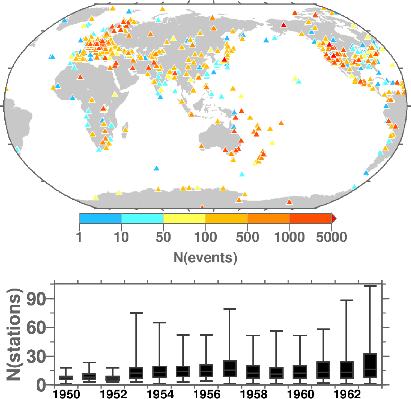
Map (top) of the distribution of the stations (triangles) between 1950 and 1963 in the BCIS for the targeted events in Figure 4. Symbols colour-coded by number of targeted events for which each station contributed. Box-and-whisker plot (bottom) of the number of stations per event in each year. The box represents the 25%–75% quantile, the band inside the box the median and the ends of the whiskers represent the minimum and maximum of all data.
3.1. Events not in the ISC database between 1961 and 1963
As already mentioned, Figure 2 shows an apparent decrease in the annual number of the targeted events in 1961–1963 compared to the trend observed in previous years. As the BCIS digitisation for 1961 began, we noticed that many events with data in the BCIS were being skipped simply because they are not included in our database. To address this shortcoming, we proceeded to the identification of events with at least 5–6 stations that are missing in our database. As a result we ended up with 1111, 1105 and 2520 events to add in 1961, 1962 and 1963, respectively. Although such an occurrence could have been expected to some extent, we were surprised by the large number of events not in our database in those three years. The reason behind the absence of so many events in the ISC database is not entirely clear. It is possible that due to time and resource limitations in the 1960s the ISC staff only created digital hypocentres for selected earthquakes (i.e., up to an amount that was possible to manage with the limited resources of the time). Nevertheless, such an addition to our database will allow us to significantly augment the Earth’s seismicity record in the immediate years before the start in 1964 of the rebuilt ISC Bulletin [Storchak et al. 2017, 2020].
The procedure to digitise these new events is only marginally different to the one described earlier. Instead of using a known event in our database, we have to create the event using the hypocentre parameters in the BCIS (i.e., origin time, latitude, longitude, depth if available, author) and use that as input to create the file with the predicted P-wave arrival and S-wave arrival truncated to the minute. The file is then edited and checked as already described and the hypocentre information used to create the new event in the database.
Figure 6 shows the distribution of the newly digitised events and the box-and-whisker plot of the number of stations associated to these events in each year. The vast majority of these events is located along subduction zones of the Pacific Ocean, but several events have been digitised around the Western US and mid-oceanic ridges. All events are earthquakes with the exception of 52 nuclear tests and one rock burst. Only a limited number of events has been added in Eurasia and Australia-New Zealand, and none in the Japanese area. The latter feature is mostly due to the fact that our database contains the pre-digital JMA network bulletin.
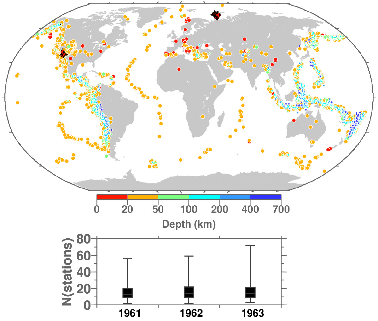
Map (top) of the distribution of the 1961–1963 newly digitised events originally missing in the ISC database (symbols colour-coded by the event depth reported in BCIS). Events classified as nuclear explosions are shown with crosshair symbols. As in Figure 5, box-and-whisker plot (bottom) of the number of stations per event in each year.
It is worth mentioning that the depth we use to create these events is the one reported in the BCIS bulletins, and for about 30% of those it is 33 km. This was the default depth value generally adopted for shallow earthquakes by various authors (e.g., CGS, US Coast and Geodetic Survey). Such a default depth is likely to be revised for earthquakes that will be relocated in future activities (see Section 4).
The summary of the number of stations shown in Figure 6 outlines a similar pattern as discussed for the events in Figures 4, 5. Hence, we expect that within these earthquakes we have several of magnitude between 5 and 6.
3.2. Event corrections
One additional benefit of this work, as already mentioned in the Introduction, is the verification of the event parameters in our record. Indeed, when digitising earthquake parameters from printed bulletins, it is possible to have cases where either coordinates and/or origin time are wrong, and only by digitising the associated data one can rectify faulty entries. One of such examples was pointed out by Okal and Langenhorst [2000] for the 11 July 1960 earthquake at 07:33:32 that in the ISC Bulletin is currently listed at latitude = −54.0 and longitude = −140.5 (Flinn-Engdahl geographic region = Pacific-Antarctic ridge). When attempting to relocate this event, Okal and Langenhorst [2000] pointed out that the initial hypocentre is affected by a typographic error in the longitude, which is actually +140.5 (Flinn-Engdahl geographic region = West of Macquarie Islands).
By digitising stations for the targeted events and with the post-editing file checks described earlier allowed us to correct several events with:
- wrong event type (e.g., earthquakes that in fact are mine-related events or nuclear explosions). This has been possible thanks to the comments within the BCIS event block information;
- errors in origin time (e.g., wrong hour);
- errors that require an event to be banished or with errors in origin time and/or coordinates that once identified resulted in the event being regrouped (i.e., merged with another event);
- errors in coordinates (e.g., wrong sign for longitude or latitude, swapped latitude-longitude and other typographical errors).
An overview of the events affected by all types of corrections is shown in Figure 7. The details of the original data and the corresponding corrections are available in a dedicated file in the supplementary material of Di Giacomo [2022].
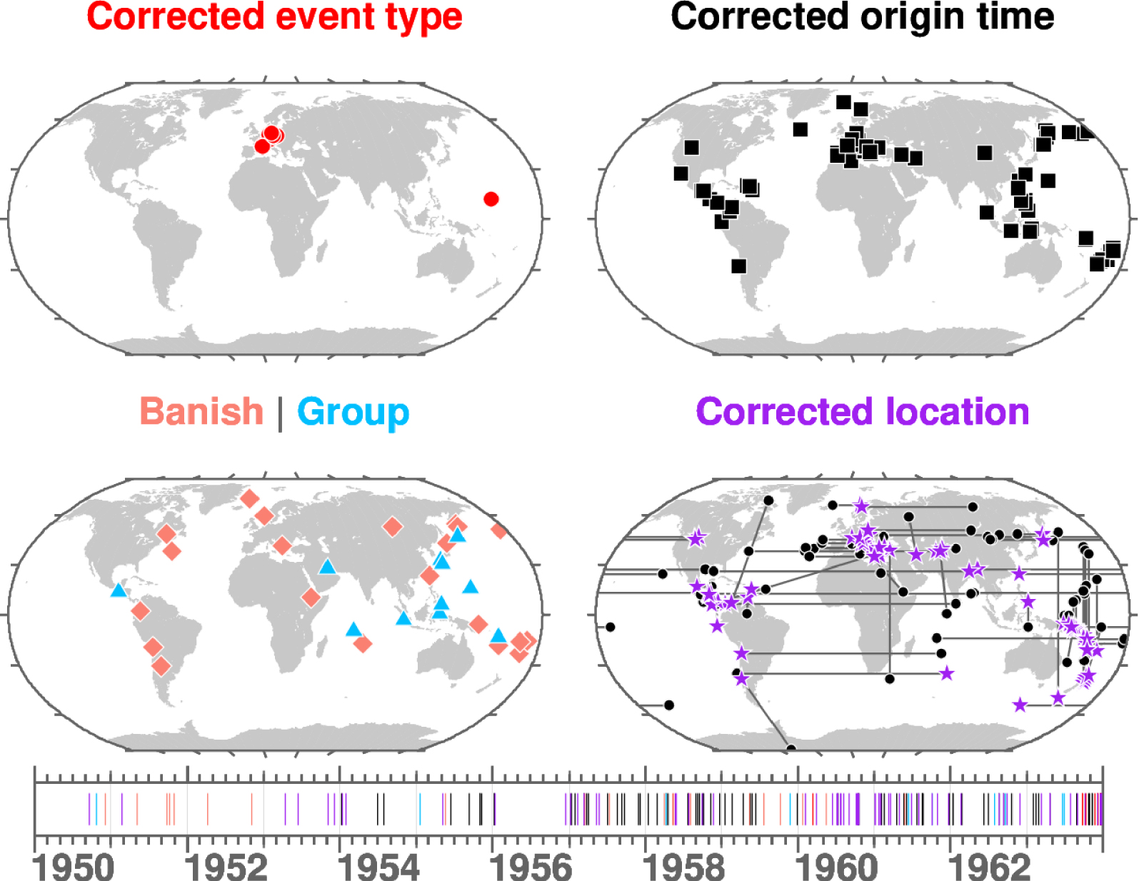
Summary of the events with updated event type (top left), corrected origin time (top right), merged or banished (bottom left) and with coordinate corrections (bottom right). In the latter black filled circles and purple stars represent the original and corrected epicentre, respectively, that are connected by a black line. The timeline of these events is shown below the maps with each segment colour-coded according to the correction applied (see maps).
3.3. Events without associated data
Despite our efforts, we could not associate station data to all targeted events in the ISC database. The geographical distribution and timeline of the events left without associated data is summarised in Figure 8. Most of them are likely too small to be listed in a global bulletin such as ISS and BCIS, particularly for all of those located in the California and western US. For example, 95 events occur in that area in 1950 and with magnitude about 4.5 and below. A few events in north Japan are immediate aftershocks of the 1952-03-04 Tokachi-Oki earthquake (Mw = 8.1). For the events in other areas still lacking associated data, we plan to search for data in individual printed station bulletins [Di Giacomo et al. 2022], ideally from close-by stations or networks. If in doing so instrumental data is found, we will be able to verify and validate these events. In Section 3.2 we have shown how important this aspect is for removing spurious entries in the record of Earth’s seismicity. This will be part of a set of future activities as detailed in the next section.

Summary of the events in the ISC database still without associated data (geographical distribution on top and timeline at the bottom).
4. Future activities
The annual files of the BCIS digitisation resulting from this work are included in the supplementary material of Di Giacomo [2022]. These files list the events digitised in chronological order. They are formatted as shown at the bottom of Figure 3, but with the exception of incomplete arrival times being removed.
Already as it is, such dataset will give us the possibility to augment the content of the ISC Bulletin 1950–1963. However, the BCIS digitisation for the targeted events give us the possibility to proceed with further activities. These include relocation [Bondár et al. 2015] and further search of magnitude related data [as the ISS, BCIS does not list amplitudes and periods required for magnitude reassessment, Di Giacomo et al. 2015a]. The relocation task would not be possible without the BCIS data digitised with this work. Indeed, compiling arrival times from individual printed bulletins of stations worldwide is a very time consuming effort and may not be possible for many stations since original printed bulletins may not have been produced or no longer available. With regard to the magnitude reassessment, it is our plan to search in station bulletins for data that will allow us to recompute, in particular, the surface wave magnitude (MS). When searching for magnitude related data in the station bulletins we will also search for any phase arrival time (i.e., not necessarily listing amplitude and periods of surface waves) to associate (and hence validate) to the events still without data discusssed in Section 3.3. Once such tasks are fulfilled, we expect to see significant improvements in terms of completeness both for the ISC Bulletin and the ISC MS dataset [Di Giacomo and Storchak 2022] during 1953–1963. The largest earthquakes (about magnitude 5 and above) will also be added to the ISC-GEM Catalogue [Storchak et al. 2013, 2015, Di Giacomo et al. 2018].
Finally, we reiterate that the BCIS digitisation has been done only for a fraction of the events. We targeted only those events for which we have more to gain (i.e., events that previously had no associated data). However, even if an event is listed in the ISS with several measurements, it would be desirable to digitise the corresponding BCIS content. This would give the possibility to confirm the data digitised from the ISS and potentially add new seismic arrivals. The BCIS digitisation procedure used here works well for events with up to a few dozen stations, but it would become cumbersome for large earthquakes, where BCIS listing can go over several pages. Therefore, to digitise all other events in BCIS we encourage the application of automatic techniques to the BCIS scans (e.g., optical character recognition and/or machine learning techniques) to produce digital files for each page of the scanned volumes. Once digital files are available, integrity checks can be run in the similar way as done during this work (i.e., checks on arrival times, phase names and so forth). The dataset we generated for the targeted events during 1950–1963 can be used as a benchmark to asses the potential of automatic digitisation techniques.
5. Conclusion
We described the effort by the ISC to digitise and make available to the community station data listed in the BCIS bulletins for targeted seismic events between 1950 and 1963. Before this work, such events had no associated measurements in the ISC database. Thanks to the BCIS digitisation we have been able to verify the initial event parameter information in our record and rectify cases affected by various types of errors (e.g., wrong epicentral coordinates, change in event type and so forth). In the process we also identified and digitised data for about 4700 events in 1961–1963 originally not in the ISC database.
In total we have added nearly 450,000 seismic wave arrival times belonging to about 20,500 seismic events between 1950 and 1963. In doing so we improved the station histories and the preservation of such data is a way to recognise the work by thousands of station operators, analysts and seismologists around the world. Such dataset will be the starting point for further work, which primarily involves relocation and magnitude reassessment. The ultimate goal is to add as many earthquakes as possible in other products (e.g. ISC Bulletin, ISC MS dataset, ISC-GEM Catalogue) to improve their completeness in the 1950s and early 1960s. This way better inputs for seismological research (e.g., Earth’s seismicity patterns, magnitude calibration, seismic hazard) will be available to the community.
Finally, more digitisation work can be done with BCIS by groups specialising in automatic character recognition of printed books. That would be important for all the large earthquakes we did not target since already listed in the ISS, whose content is fully digitised. The dataset we generated from our digitisation effort can be used as benchmark for automatic digitisation procedures.
Conflicts of interest
The authors declare no competing financial interest.
Dedication
The manuscript was written through contributions of all authors. All authors have given approval to the final version of the manuscript.
Acknowledgments
Daniela Olaru, Rian Harris and Susana Carvalho were instrumental to this work for digitising the arrival times of BCIS bulletins. The historical dataset of the Japanese Meteorological Agency (JMA) has been kindly provided by Nobuo Hamada. James Harris provided useful suggestions whilst we developed the procedure to digitise the BCIS bulletins. We are grateful to two anonymous reviewers for their comments that helped us to improve the manuscript. The ISC is able to continue its mission thanks to the support of its members (http://www.isc.ac.uk/members/ last access: August 2022), including the National Science Foundation (NSF) Award 1811737. The authors are also grateful to sponsors that help to fund the ISC development projects: CTBTO, FM Global, the Lighthill Risk Network, AXA XL, SARA, GeoSIG and MS&AD. All figures were drawn using the Generic Mapping Tools [Wessel et al. 2013].