

Version française abrégée
1 Introduction
Cinq carottes ont été acquises par le Marion Dufresne en octobre 2001 dans le golfe de Corinthe [4]. Leurs positions exactes et leurs longueurs sont synthétisées sur les Figs. 1 et 2 et dans le Tableau 1. Le but était de déterminer les vitesses de subsidence dans le golfe de Corinthe, le rejet de la faille majeure au nord du basin central (F1), ainsi que de caractériser la nature d'une structure positive et d'une avalanche de débris à l'est du golfe. Il s'agit à l'heure actuelle des plus longues carottes existantes dans la partie marine du golfe de Corinthe.
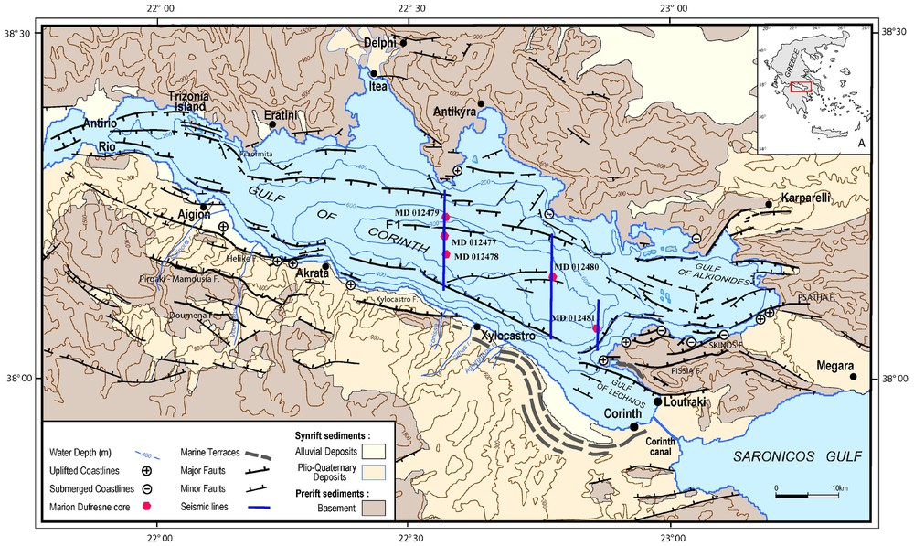
Structural map of the Gulf of Corinth with the location of the cores and seismic lines (modified from [11]).
Carte structurale du golfe de Corinthe montrant la localisation des carottes et des lignes sismiques (modifiée d'après [11]).
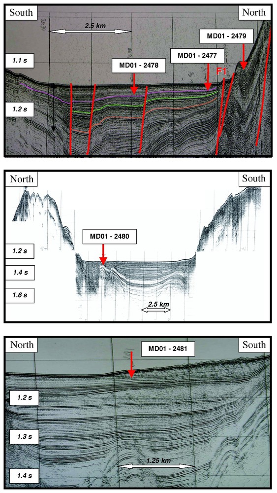
Time seismic lines across the Gulf of Corinth with the location of the five cores. See location in Fig 1. NCMR proprietary data.
Lignes sismiques temps à travers le golfe de Corinthe montrant la position des cinq carottes. Voir localisation sur la Fig. 1. Ces données sont la propriété du NCMR.
Location and length of the cores
Localisation et longueur des carottes
| Station | Latitude | Longitude | Water depth [m] | Final length [m] |
| 10 – MD01-2477 | 38°13.28′ | 22°33.53′ | 867 | 20.08 |
| 11 – MD01-2478 | 38°11.68′ | 22°33.51′ | 861 | 2.97 |
| 12 – MD01-2479 | 38°13.83′ | 22°33.63′ | 837 | 19.6 |
| 13 – MD01-2480 | 38°09.2′ | 22°47.57′ | 852 | 29.73 |
| 14 – MD01-2481 | 38°05.49′ | 22°51.40′ | 847 | 15 |
2 Description et âge des carottes
Les sédiments traversés dans la partie supérieure des carottes sont des turbidites marines silto-sableuses à dominante carbonatée, intercalées dans une sédimentation hémipélagique homogène riche en matière organique et marquée par une augmentation du contenu planctonique vers le sommet (carotte MD01-2477). Ces dépôts correspondent pour l'essentiel à la série holocène. Le passage aux niveaux lacustres se fait à 13,60 m dans la carotte MD01-2477 (hangingwall de la faille), à 11,95 m dans la carotte MD01-2479 (footwall) et à 13,46 m dans la carotte MD01-2480. L'âge des derniers dépôts marins est de 13 210 ans sur cette carotte [9]. La carotte MD01-2481 a traversé une avalanche de débris et s'est arrêtée à 15 m, dans des dépôts datés à 7320 ans. Les plus vieux éléments dans l'avalanche de débris sont datés à environ 28 000 ans.
Dans toutes les carottes ont été réalisées des analyses de gaz. La seule qui en contenait de façon significative était la carotte MD01-2480. Les analyses ont montré qu'il s'agissait à 93 % de méthane biogénique et à 7 % de dioxyde de carbone, avec une signature classique d'origine marine ( versus PDB pour le CH4 et versus PDB pour le CO2).
3 Discussion et conclusion
La vitesse de déplacement sur la faille F1, déduite des carottes de part et d'autre, est d'environ 1 mm a−1 pour le rejet vertical. L'analyse des données sismiques (Fig. 2(b)) permet de déduire des données des carottes les vitesses de sédimentation dans le dépôt-centre du golfe : environ 1,8 mm a−1 pour les derniers 20 000 ans (voir [9] pour les détails de cette analyse). La vitesse d'ouverture de la faille F1 est similaire à celles enregistrées sur la faille d'Helike [9,12] et confirme la répartition de l'ouverture du golfe sur diverses failles à pendage nord et sud [10].
Les dépôts syn-rift du golfe de Corinthe montrent une alternance constante de conditions marines et lacustres. Dans ce contexte général, l'existence du « lac de Corinthe » durant les derniers milliers d'années avait déjà été décrite par Perissoratis et al. [11,13] et Collier et al. [8]. Collier et al. proposent un âge de 12 000 ans pour la dernière transgression marine. Les nouvelles données acquises ici permettent d'abaisser légèrement l'âge de la remise en eaux du lac par la Méditerranée, qui serait donc d'au moins 13 200 ans. Lemeille et al. [6], à partir des carottes faites dans le port d'Aigion par le projet Corseis, ont observé aussi ce passage aux dépôts lacustres avant 12 000 ans. L'étude de l'ensemble des données des sédiments récents dans le golfe de Corinthe ont permis à Lykoussis et al. [9] de quantifier à environ −100 m le niveau du lac (ce dernier étant demeuré relativement stable d'après les données sédimentologiques). Le haut-fond de Rio-Antirio étant à 62 m, cela implique qu'il existait un décalage d'environ 40 m entre le niveau de la Méditerranée et le niveau du golfe de Corinthe lors de l'intrusion marine. Ce phénomène a pu donc être de type catastrophique, comme il l'a été en mer Noire [16].
1 The campaign
The Corinth-survey has been part of Geoscience-II campaign, carried out in October 2001 on board the French RSS Marion Dufresne [4]. During this campaign, 5 long ‘Calypso’ piston cores have been recovered. Various analyses have been performed on these cores: geophysical logging (including magnetic susceptibility, gamma ray, resistivity, sonic, etc.), core description (including smear slides), extensive sampling at constant volume (for micropalaeontology and for calculations of petrographical parameters, including porosity and mineralogy), and AMS radiochronology. The cores are stored in the core depository of the ‘Muséum national d'histoire naturelle’, Paris, France.
The structural map in Fig. 1 shows the location of the samples, the Table 1 the GPS values, whereas Fig. 2 displays three seismic lines on which the cores are located. The main goals were (i) to determine the subsidence and sedimentation rate in the Gulf of Corinth, (ii) to quantify the slip rate on the fault F1, which is the northern marginal fault of the central Gulf of Corinth (Figs. 1 and 2). The cores MD01-2477 and MD01-2479 were collected on the hanging- and footwall of this fault. The core MD01-2478 (gravity core) was collected as a reference core on an undisturbed part of the basin but the recovery was very low due to the lack of penetration. The core MD01-2480 was designed to define the nature of the positive structure in Fig. 2(b) and the core MD01-2481 to date the debris flow visible in Fig. 2(c). The seismic database of the National Center of Marine Research in Athens has been used to extend the conclusions deduced from the core to the basin [9].
Gas sampling was done on all the cores through the PVC tube, but only core MD01-2480, located at the top of the positive structure shown in Fig. 2(b), provided significant gas content.
2 Core description
The piston coring capabilities of RSS Marion Dufresne enabled us to recover four undisturbed sediment cores up to 30 m in length (see Table 1). Two distinct sediment successions were recognised along the split cores (Fig. 3, see pictures in Fig. 4). The upper succession corresponds to mostly Holocene marine deposits, while the lower one is comprised of lacustrine facies deposited during the last Late-Glacial times. Three cores, MD01-2477, MD01-2479 and MD01-2480, succeeded in penetrating this lacustrine succession, at 13.60, 11.95 and 13.46 mbsf, respectively.
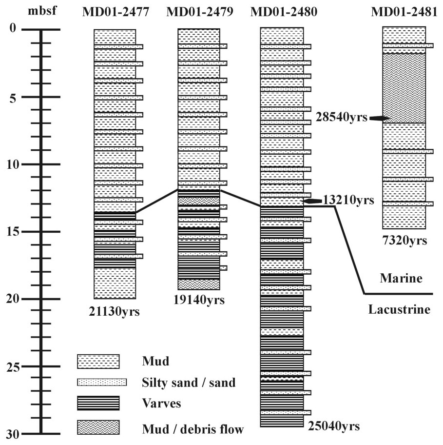
Simplified sedimentological logs of the piston cores MD01-2477, MD01-2479, MD01-2480 and MD01-2481. AMS ages obtained on the six samples from all cores are indicated. The marine/lacustrine interface corresponds to reflector Z of Fig. 2. Modified from [9].
Description sédimentologique simplifiée des carottes MD01-2477, MD01-2479, MD01-2480 et MD01-2481. Les âges AMS obtenus sont indiqués sur les échantillons. L'interface marin/lacustre correspond au réflecteur Z sur la Fig. 2. Profils modifiés d'après [9].

Pictures of the two main facies, marine sediment in the upper part (pictures at 6 and 8 m depth) and lacustrine below (pictures at 13 and 14 m depth) in the MD01-2479. The core between 12.5 and 13 m shows mud clasts and debris flow suggesting catastrophic flow, potentially due to slope instability and/or earthquake.
Photo des deux principaux faciès, marin dans la partie supérieure (photo de la demi-carotte à 6 et 8 m) et lacustre en dessous (photo à 13 et 14 m), carotte MD01-2479. La carotte entre 12,5 et 13 m montre de nombreux clastes, suggérant un apport catastrophique, qui peut être dû à une instabilité de pente et/ou à un tremblement de terre.
The marine succession mostly consists of poorly laminated grey-to-greenish muddy strata locally interrupted by erosively sharp-based, fining upward, 1 mm- to 2 cm-thick sandy beds (occurring at the rate of 5 to 10 per metre of sediment). The pervasive muds are made up of mostly detrital, terrigenous carbonate silts, with few clays and an increasing content of calcareous nannofossils toward the top, pointing to an hemipelagic origin for the bulk of this sediment. Locally abundant specks, flakes or thin laminae (<1 mm) of organic matter, including plant fragments, occur in the muddy matrix. These deposits are related to episodes of higher fluvial input into the gulf. The fluvial domination in terrigenous input is also expressed by the sandy beds, which are interpreted as distal turbidites. The sandy fraction is terrigenous, fine-grained with well-sorted and sub-angular to well-rounded grains, implying a shallow water origin. Slope instabilities are also possibly responsible for some debris flows, as shelly layers up to 20 cm are composed of littoral fauna bioclasts (namely gastropods). AMS dating of a sediment sample from the base of this marine succession, taken from the core MD01-2480 at 13.42–13.46 mbsf, yielded a conventional radiocarbon age of yr BP (Fig. 3).
The lower sediment succession extends from 12–14 mbsf down to the base of all three cores. The bulk of the deposition within this succession is also composed of silty mud, the bedding of which is locally expressed by laminae of various colours (grey, brownish olive grey, olive grey, greenish grey, black …). This pattern is related to cyclic changes of redox properties at the water-sediment interface. Microgranulometrical analyses show a grain-size sorting at the laminae scale, pointing to a relationship of water chemistry and sediment supply. Both observations are typical of lacustrine varved sedimentation, where water stratification is seasonally controlled. Another hint for episodic confinement within a lacustrine system is the occurrence of white laminae of probable aragonitic silty grains, interpreted as chemical precipitation in the (oversaturated) water column of an evaporitic lake. Such deposits have been reported from the offshore Plio–Pleistocene lacustrine sediments outcropping in Corinth (proto-Corinth Gulf lake deposits) and in the Late-Glacial lacustrine sediments of the western Saronikos Gulf (located east from the Gulf of Corinth) [7,15]. Near the northern shore of the Gulf of Corinth (Itea Gulf and Vouraikos River mouth), Heezen et al. [5] also reported varve-like sediments from two cores. Fresh and brackish water foraminifera and ostracods found in the varves were identified as pre-Pleistocene. Salinity stresses could control specific fauna blooms, such as among diatoms. Specific diatom rich levels have been found in the core MD01-2479 between 14 and 17 m (study in progress). Also, this succession is characterised by the abundance of sandy/silty thin graded beds/laminae interpreted as distal turbidites. These turbidites occur at the rate of 10–15 events per metre of sediment. They are likely to correspond to distal deposition of very strong fluvial floods, occurring in the lake at a ca. decadal time scale. Although this is not studied yet from the core record, the behaviour of turbiditic flows in the lake could have been quite different from that in the marine basin (ca. hyperpycnal underflows, stronger grain-size parting, etc.).
The boundary between both successions is sharp and well expressed in the three cores. In the MD01-2479, it is marked by a 5 cm aragonitic layer (fibrous crystals). It lacks coarse-grained basal lags associated with marine flooding, but this is due to the presence of a still deep lake at the time of marine entrance. This boundary is correlated to the reflector Z in the seismic profiles, which should record the extent of the Late-Glacial lacustrine sediments of the Gulf [9].
Slope instabilities seem to have occurred in the cored area throughout the history of the lacustrine and marine post-glacial section. They are expressed as mudflow deposits identified in the middle and lower section of core MD01-2479 and extensively along the upper half of the core MD01-2481, where they occur within marine deposits as highly disrupted, chaotic blocks of folded and fluidised muds with mud clasts and rafted varved laminae sets eroded from the lacustrine facies below (Fig. 3). The symmetrical dip change of stratal boundaries around the most dislocated sediment package within this deposit suggests the shape of a slump fold.
The P-wave velocity values range between 1550–1800 m s−1. The lower values were observed in the upper half of the cores and the relatively higher ones (>1600 m s−1) in the lower half. Consequently, a mean value of 1690 m s−1 should be a representative P-wave velocity for the upper few tens of metres of the Late-Quaternary sediments of the Corinth Basin. This is consistent with unconsolidated fine-grained sediments oversaturated by water (filled porosity). Calculations based on density measures (assumed from wet and dry sediment weights) result in porosity values decreasing from top to bottom from about 60 to 50% for the core MD01-2479.
3 Gas shows from core MD01-2480
This core showed a much higher gas concentration than other cores; gas was mainly located in its deepest part. Before removing the steel tube, gas was already bubbling through the tube joints. It was possible to sample the gas at sediment depths of 12.9, 23.7, 25.5 and 25.9 m, respectively. We sampled it in stainless steel cylinders in order to measure the chemical and isotopic compositions of the associated noble gases. The element and isotope analyses performed on the deepest gas samples of this core show a purely bacterial gas, consisting of methane (93%) and CO2 (7%). The carbon isotopic composition of methane is very light ( versus PDB), whereas CO2 has a usual isotopic signature of oceanic sediments ( versus PDB).
4 Carbonate content of core 2479
Carbonate contents measured on MD01-2479 at an average spacing of 20 cm show values ranging from 35 to 60%, but with significant differences from the lower lacustrine succession to the upper marine one (Fig. 5). The average value in the lacustrine succession is 54% compared with 39% in the marine upper part, where no determination exceeds the lowermost carbonate content of the lacustrine succession. This suggests that the bulk carbonate content within the core is not of planktic origin but rather terrigenous. Such an interpretation is supported by the analysis of smear slides, which shows (i) a weak abundance of nannoflora in the marine succession (ii) the dominance of reworked clastic carbonate grains in the silty fraction.

Magnetic-susceptibility logs of piston cores MD01-2477, MD01-2479 and MD01-2480. The boundary between lacustrine and marine sediments is well marked. Note the averaged low values and flat curve of MS of the marine deposits, by contrast to the highly variable response within the upper 5 m of the lacustrine section. It is hypothesised that most of the SM excursions could be associated to pyritized reduced OM (study in progress).
Profil de susceptibilité magnétique dans les carottes MD01-2477, MD01-2479 et MD01-2480. La frontière entre les sédiments lacustres et marins ressort clairement. La courbe de susceptibilité magnétique est très homogène dans la partie marine et indique une valeur assez faible, alors que le signal montre une très grande variabilité dans la partie lacustre, en particulier dans les 5 m supérieurs. Nous supposons que ces variations sont associées à une réduction de la matière organique (travail en cours).
5 Discussion
The subsidence rate is extrapolated from the dated reflectors on the seismic line in Fig. 2(a), from the cores to the basin's depocentre. This suggests a subsidence rate of 3.6 mm yr−1 in the centre of the basin during the last 20 000 yr and the maximum sedimentation rate is 1.8 mm yr−1. The slip rate of the major south dipping fault in the central northern part of the Gulf is 1.6 mm yr−1 during the same period. This value is similar of the Helike fault offset for the last 125 000 yr [9,12] and half of the slip rate measured on the same period in the Aigion fault (3.4 mm yr−1 during the last 30 000 yr, Lemeille et al., this issue).
The new piston cores in the deepest part of the Gulf of Corinth highlight the importance of lacustrine deposition in this basin. The lacustrine stage evidenced, which is the latest one, has not been the only one during the Quaternary. While the Gulf of Corinth is wide to the east (30 km), with water depths reaching 860 m [1], to the west it narrows to 6 km and shallows to 62 m above the Rio–Antirio sill [14]. This morphological contrast is inherited from the structure of the basin, as the thickest synrift sequence (up to 2.4 km, [2]) is located in its eastern part. Due to the shallow depth of the Rio–Antirio sill and to the Late-Pleistocene sea-level fluctuations, the Gulf has been periodically transformed into a lake. This continuous alternation, since the beginning of the sedimentary record of extension, is also clearly recorded by the outcropping sediments that waver between lacustrine and marine facies. For the most recent period, this alternation has been proven for the western part of the Gulf by the core analyses of the sediment aged from 11 800 yr to about 41 000 yr BC collected in the Aigion Harbour [6], and by the sequence stratigraphy analyses of the prodelta sequences of the upper northern slope of the Gulf, offshore Eratini [8]. The lacustrine facies have been also described from seismic reflection profiles eastward, in the Alkyonides sub-basin [11,13,14]. One of these studies suggests an age of about 70 000 yr for the start of the (last) so-called ‘Corinth Lake’, and 12 000 yr for the last marine transgression [14]. Until about 300 000 yr BP, the Gulf of Corinth was also open eastward to the Saronikos Gulf. The marine deposits of that time are now uplifted and exposed along the Corinth Canal, where they have been dated at 312 000 yr ago [3].
Sequence stratigraphic analysis of prodelta prograding sequences below the Eratini shelf and upper slope revealed the presence of successive low-stand system tracks, which undergo continuous subsidence during the last 250 kyr. The topset-to-foreset transition of the last low stand prodelta deposits indicates that the Corinth Lake's level was about 75 m lower than the present sea level [9]. It means that flow similar to that which has been described for the Black Sea [16] could also have taken place in the Gulf of Corinth. It is known that fairly organised human communities (and settlements) in the Aegean area date back to 35 kyr before present. It is thus reasonable to assume that large-scale water level change, which took place 13 kyr BP, may have survived as oral traditions and myths. Additional multidisciplinary works are now necessary to specify the human impact of such a phenomenon.
Acknowledgements
We thank the officers and the crew of the RSS Marion Dufresne for their significant assistance in the fieldwork. Namely, the Marion Dufresne coring should have been impossible without the expertise of Y. Balut (IPEV). We thank all the colleagues who have participated to the analyses, storage and carriage of the cores, especially L. Micarelli, L. Le Pourhiet, J. Schmitz (all from IFP), C. Robin (Paris-6), P.-J. Giannesini (MNHN).