

1 Introduction
The convergence of Europe and Africa during the Cretaceous–Tertiary resulted in the continental collision and consequently in the orogenic Alpine build-up and the almost complete consumption of the westernmost part of the Tethys Ocean. The Betic and Rif cordilleras form an arc-shaped mountain belt lying at both sides of the Strait of Gibraltar (Fig. 1A). The building-up of the Betic and Rif cordilleras produced the narrowing and the partial closure of the Atlantic–Mediterranean passages.
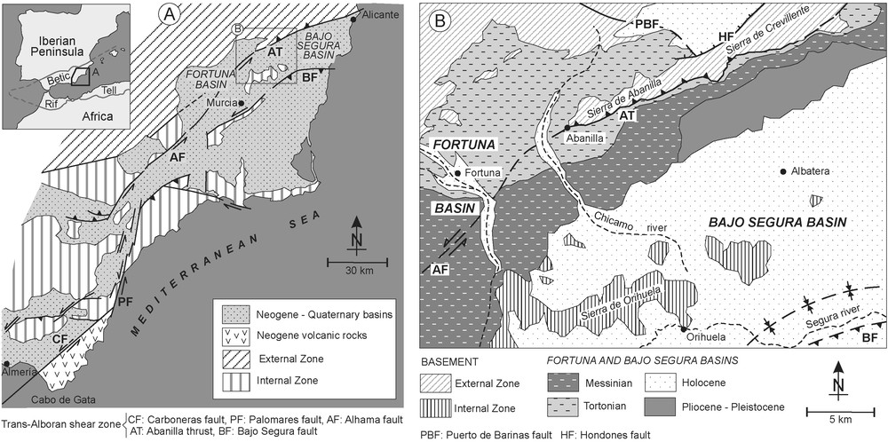
(A) Geologic sketch of the Eastern Betic Cordillera (after [5], modified) showing the strike-slip faults forming the TASZ. (B) Geologic map of the Fortuna and Bajo Segura basins and the location of the Crevillente–Abanilla lineation.
(A) Schéma géologique des cordillères Bétiques orientales (modifié d’après[5]), qui montre les failles de décrochement de la bande décrochante trans-Alboran. (B) Carte géologique schématique des bassins de Fortuna et du Bajo Segura et localisation du linéament Crevillente–Abanilla.
Before the Messinian Salinity Crisis (MSC, [22]) occurred, the Atlantic–Mediterranean passage was done by the Norbetic and Rifian straits, both representing the foreland of the Betic and Rif cordilleras, respectively. The central ‘islands’ were formed by the Alboran Terrane and the Betic and Rif cordilleras. In the Late Tortonian, both forelands were thrust by the outer tectonic units, Prebetic [31] and Prerif [4]. In the Fortuna and Lorca basins, this early restriction, occurring before the Messinian Salinity Crisis, was called the Tortonian Salinity Crisis (TSC) by Krijgsman et al. [12], because in those basins the first evaporites were thought to be Tortonian.
The main Betic Cordillera orogenesis took place in the Early and Middle Miocene. This is the reason why most of the tectonic studies have been focused in this interval of time. The knowledge of the structuring period produced a good picture of the regional geology [4,10,17]. However, the result of the less known late orogenic modifications, Late Miocene in age [1,2,5,15,19], affected a much larger area, the whole Mediterranean basin producing its desiccation [22].
This study analyses the last structuring phases of the Betic Cordillera to show that they had not less important consequences than the main one, not only because these phases can help us to refine our understanding of the regional geology, but also because they had relevant regional and, even, global effects, as the increase of the global sea level due to the Mediterranean desiccation [22]. The aim of this work is to relate these phases with the initial restriction of the basins that would lead to the Tortonian and Messinian salinity crisis.
2 Tectonic framework
The Trans-Alboran Shear Zone (TASZ) is a major active left-lateral strike-slip fault zone running from Alicante to the Cabo de Gata (Almeria) [5]. It is formed by a set of strike-slip faults relaying from south to north: Carboneras, Palomares, Alhama de Murcia, and the northern border of the Bajo Segura Basin faults (Fig. 1A). The onset of the stress field responsible for the TASZ occurred in the Late Tortonian–Early Messinian [11]. The Fortuna and Bajo Segura basins are situated onshore the northeastern end of the Trans-Alboran Shear Zone (TASZ), where its interaction with a major suture zone, the Internal–External Zone Boundary, represented by the older Crevillente Fault [30], bend the TASZ to the east. The Abanilla and Crevillente sierras form the positive relief of the Crevillente–Abanilla lineation, with a N070°E direction. This lineation is bordered to the west by the Earliest Tortonian–Pliocene Fortuna Basin and to the east by the Late Tortonian–Recent Bajo Segura Basin.
The N050°E left-lateral Alhama de Murcia Fault can be traced northward from Lorca to the Fortuna Basin. The northward movement of its eastern block against the Internal–External Zone Boundary suture produced the development of a compressive ridge, the Abanilla Thrust, giving rise to the Abanilla Sierra (Figs. 1B and 2). At the southern slope of the sierra, abundant fault planes are developed in the Fortuna Marls, indicating a high activity of the Abanilla Thrust. In the western block of the Alhama de Murcia Fault, the trace of the old Puerto de Barinas Fault [30] appears bent with an S-shape, indicating its modification by the TASZ left-lateral shear zone (Fig. 1B).
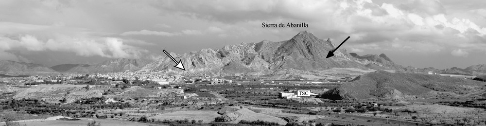
Photography of the Abanilla Thrust front from the Abanilla village to the Montealto hill to the northeast. The arrows point the thrust plane. TSC: Tortonian Salinity Crisis.
Photographie du front du chevauchement d’Abanilla depuis le village d’Abanilla jusqu’à la colline de Montealto, au nord-est. Les flèches signalent le plan de chevauchement. TSC : Crise de salinité tortonienne.
3 Stratigraphic record
The special attention received by the Fortuna Basin is mainly due to the presence of evaporitic deposits [6–8,12–14,18,20,23,27,28]. The dating of the major evaporitic episode (Tale Gypsum) as Tortonian have permitted Krijgsman et al. [12] to propose a Tortonian Salinity Crisis (TSC) that can be interpreted as a restriction phase due to tectonics [6–8]. The Bajo Segura Basin was less studied [18,19], but has been recently the target of many works [3,25–28]. It presents evaporitic deposits as well (San Miguel Gypsum), but they are situated in the upper part of the Messinian succession [19] and can be related to the MSC. The northern margin of both basins corresponds to the External Zone of the Betic Cordillera, composed of Mesozoic sedimentary rocks (limestones, marls, sandstones, and shales). In the southern part, some Internal Zone outcrops stick out, as the Orihuela Sierra (Fig. 1B). These outcrops correspond to Palaeozoic and Triassic low-grade metamorphic rocks (marbles, schists, phyllites, and igneous basic) of the Alpujarride Complex.
The study of the intermediate zone that separates both basins has permitted to compare the Fortuna and Bajo Segura basins. Fig. 3 shows the correlation between the lithological units composing the Fortuna Basin, the infill of the intermediate zone and the northwestern part of the Bajo Segura Basin.
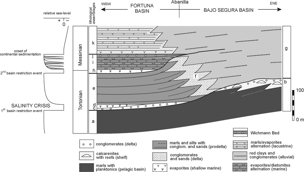
Correlation sketch panel throughout the Bajo Segura and Fortuna basins. Lithological units: (a) Fortuna Marls; (b) Las Ventanas Limestone; (c) Fenazar conglomerate Fm; (d) Lower Gypsum; (e) Sanel Marls; (f) conglomerates and sands (deltaic facies); (g) Albatera red beds; (h) Tale Gypsum; (i) Chicamo diatomites and gypsum cycles; (j) Wichmann Bed; (k) Rambla Salada Gypsum.
Schéma de corrélation entre les sections stratigraphiques du secteur d’étude. Unités lithologiques: (a) marnes de Fortuna ; (b) calcaire de Las Ventanas ; (c) conglomérat de Fenazar ; (d) gypses inférieurs ; (e) marnes de Sanel ; (f) conglomérats et sables (faciès deltaïque) ; (g) couches rouges de Albatera ; (h) gypse de Tale ; (i) cycles de diatomites et gypse de Chicamo ; (j) couche de Wichmann ; (k) gypse de Rambla Salada.
Whitish marls, rich in microfossils of marine planktonic organisms representing an early fully marine environment [18], outcrop at the base of the Bajo Segura Basin and are laterally equivalent to the Fortuna Marls, in the Fortuna Basin. In the centre of this basin (Rio Chicamo section, Fig. 4A), the uppermost levels of the Fortuna Marls contain a nannofossil association of Discoaster berggrenii, Discoaster quinqueramus and Reticulofenestra pseudoumbilicus >7 μm [27], indicating the CN9a biozone of Okada and Bukry [21], corresponding to the upper Late Tortonian.
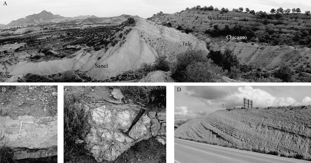
Photographs of the different gypsum beds: (A) panoramic view of the Rio Chicamo section; (B) Tale Gypsum faciès; (C) gypsum bed with stromatolites of the Chicamo diatomites and gypsum cycles; (D) Rambla Salada gypsum facies on the road cuts of the Abanilla–Santomera road.
Photographies des lits de gypse : (A) vue panoramique de la section du rio Chicamo ; (B) faciès du gypse de Tale ; (C) couche de gypse avec stromatolites des cycles de diatomites et gypse de Chicamo ; (D) faciès de gypse de Rambla Salada sur les coupes de la route d’Abanilla–Santomera.
In the northeastern part of the Fortuna Basin, overlying the Fortuna Marls, appears a calcarenitic and reefal unit: Las Ventanas Limestone. This stratigraphic unit also occurs in the northern border of the Bajo Segura Basin and can be followed along the southeastern slope of the Crevillente–Abanilla lineation. It corresponds to the first deposit sealing the Puerto de Barinas Fault and the first one deposited in the Bajo Segura Basin as an individualized basin [30]. Las Ventanas limestone was deposited in a shallow marine platform facing the eastern Mediterranean Basin.
In both basins, an important discontinuity is developed on top of the Las Ventanas Limestone that is overlaid by conglomeratic units (Fig. 3). These have red continental facies in the Bajo Segura (Albatera red beds), fan delta facies in the intermediate zone (conglomerates and sands) and conglomerate marine facies with lithofaga-bored metamorphic clasts of Internal Zone provenance (Fenazar conglomerate) in the centre of the Fortuna Basin [23,24,29].
Four evaporitic assemblages appear in the Fortuna Basin over the Fenazar conglomerate [29]: (1) Lower Gypsum–Sanel marls; (2) Tale Gypsum; (3) Chicamo diatomites and gypsum cycles; and (4) Rambla Salada Gypsum. The first three assemblages have marine influence, but the fourth is mainly continental.
The Lower Gypsum is well developed in the centre of the Fortuna Basin and corresponds to the first register of evaporitic sedimentation in the Fortuna Basin. The Lower Gypsum is overlaid by a marly unit, with planktonic microfossils and intercalated centimetric gypsum beds called the Sanel Marls Fm. This unit contains the same nannofossils association found in the upper part of the Fortuna marls [29]. Eighty metres above, the Lower Gypsum Ammaurolithus primus [27] is first recorded, which marks the CN9b biozone of Okada and Bukry [21], corresponding to the uppermost Late Tortonian. Thus, the Lower Gypsum–Sanel Marls (the first evaporitic assemblage in the basin) must be assigned to the Latest Tortonian. Laterally, to the eastern basin's margin, the Lower Gypsum changes to sandstones levels having oscillation ripples and hummocky cross stratification, and some gypsum beds. In the intermediate zone, the Sanel Marls changes to deltaic conglomerates and sands, passing in the Bajo Segura Basin to continental conglomerates and red shales (Fig. 3). The remaining evaporitic assemblages of the Fortuna Basin also change laterally to continental conglomerates and red shales in the Bajo Segura Basin, but it has not been possible to distinguish in them the equivalent units of the evaporitic assemblages.
Over the Sanel Marls appears the next evaporitic assemblage, the Tale Gypsum (Fig. 4B), a 30-m-thick gypsum unit formed by selenitic gypsum with laminated caps and some marly intercalations with nodular gypsum. Krijgsman et al. [12] consider the Tale Gypsum as the result of the TSC. No biostratigraphic data can be used to date this level, but the recalibration of the published magnetostratigraphic successions of Dinarès-Turell et al. [6] and Krijgsman et al. [12] with our nannofossil data allow us to consider that the Tortonian/Messinian boundary may be situated into or near the Tale Gypsum (Fig. 3) [30].
The Chicamo diatomites and gypsum cycles evaporitic assemblage is formed by five cycles of diatomitic marls and gypsum beds with stromatolites (Fig. 4C). The top of this unit corresponds to an erosive surface overlaid by the Wichmann Bed [23], a shallow marine conglomerate containing abundant macrofossils (bivalves, bryozoans, corals, and echinoids), in addition to metamorphic clasts derived from the Internal Zones. The diagenetic study of Santisteban and Taberner [24] indicates a post-depositional subaerial exposure for this bed.
Finally, the Rambla Salada evaporitic assemblage (Fig. 4D), an alternation of marls and gypsum beds, appears in the centre of the Fortuna Basin. The basal part shows marine influence, while the rest is entirely continental, deposited in a shallow-water lacustrine environment [23,24].
4 Discussion
The Puerto de Barinas Fault is one of the NW–SE faults set responsible for the Prebetic thrusting over the foreland and the closing of the Norbetic passage [28]. Its activity ceased when the strait was closed; therefore, the compressive stress due to the northward movement of the African Plate [16] needed other faults to accommodate. This northward movement produced the TASZ in the eastern Betic Cordillera and the kilometre-scale east–west striking fold in the centre of the cordillera [1]. The onset of the TASZ is recorded in the study area by the conglomerates over the marine Fortuna marls indicating the uplift of the nearby areas as the Abanilla Sierra and the surrounding Internal Zones (Orihuela and Callosa sierras).
The Fortuna Basin was formed in the Earliest Tortonian (older sediments of the basin [18,23]) on the suture zone between the South-Iberian palaeomargin and the Alboran block (Internal–External Zones boundary). The thick Fortuna Marls indicate a high subsidence rate and the narrow basin shape of the Fortuna Basin could point out to a pull-apart basin associated with a strike-slip fault. During the Tortonian, the nearby areas of the Puerto de Barinas Fault were covered by thick conglomeratic sediments [13,14,23]. Therefore, the Puerto de Barinas Fault could be one of the faults responsible for the development of the Fortuna pull-apart basin. The local extensive stress field produced the high subsidence rate needed to accumulate the thick Fortuna Marls. Two infill periods can be differentiated in the basin. During the first one, which took place during the Tortonian, marine sediments, at least 600-m-thick Fortuna Marls and Las Ventanas Limestones, were deposited. The second one, developed from the Latest Tortonian to the Pliocene, deposition was dominated first by more or less marine sediments, and then by continental sediments. These two periods are associated with different tectonic settings. The first one was controlled by the activity of the transtensive right-lateral faults as the Puerto de Barinas Fault [30]; the second started when the activity of the faults stopped and a new tectonic stress field, the Trans-Alboran Shear Zone, was established [28]. The discontinuity developed over Las Ventanas Limestone marks the base of the second basin infill period.
The Bajo Segura Basin developed as an individualized basin after the sealing of the Puerto de Barinas Fault, coinciding with the second stage of the Fortuna Basin, as a tectonic corridor located between the northern Hondones Fault and the southern Bajo Segura Fault, both branches of the TASZ. At the end of the Tortonian, the initiation of the thrust activity, related to the TASZ onset, created new relieves and the northwestern Bajo Segura Basin emersion, as evidenced by the development of continental red shales facies, while in the Fortuna Basin marine influences were still present. The erosion of those relieves produced the conglomerate clasts input to the basins. The first conglomerates, corresponding to the Fenazar Fm in the Fortuna Basin and to the conglomerate levels of the Albatera red beds on top of the Las Ventanas Fm in the Bajo Segura Basin, mark the start of the process. The provenance of these detritics indicates the newly created source areas: the Fenazar Fm clasts come from the Internal Zone, evidencing the existence of the Callosa and Orihuela sierras southern relieves, while the northern relieves feed, with External Zone clasts, the northwestern Bajo Segura Basin and the intermediate zone (Fig. 5), marking the initiation of the Abanilla Thrust.
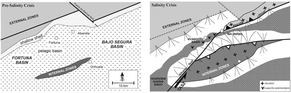
Palaeogeographic reconstructions of the study area before and after the TSC. TASZ: Trans-Alborán Shear Zone.
Reconstruction de la paléogéographie du secteur d’étude avant et après la crise de salinité tortonienne. TASZ : Bande décrochante tras-Alboran.
5 Conclusions
The new palaeogeographic conditions allowed the sedimentation of marine evaporitic facies (Lower Gypsum) in the centre of the Fortuna Basin. This first evaporitic event marks the start of the TSC. Therefore, there is a good correlation between the onset of the TASZ in the Fortuna Basin, the initiation of the Abanilla Thrust and the Tortonian Salinity Crisis. Krijgsman et al. [12] considered that the Tale Gypsum represented the initiation of the evaporitic sedimentation and the beginning of the TSC. We keep the name TSC considering that the Tale Gypsum was not the first, but the second evaporitic episode. Consequently, the restriction event marking the start of the TSC should be placed below, in the Fenazar conglomerate bed, at the bottom of the Lower Gypsum.
The presence of nannofossils characteristic of open marine waters in the Sanel Marls, overlying the Lower Gypsum, indicates that the connection with the open sea persisted after the first evaporitic event. The second evaporitic assemblage, Tale Gypsum, marks another restriction event, with only limited marine input adding the salts. In these conditions, a thick gypsum bed with halite pseudomorphs was formed [23]. The next evaporitic assemblage, with diatomites and gypsum cycles, indicates an alternation in the conditions of basin restriction. Finally, the last marine retreat of the basin occurs after the Wichmann Bed, after the gypsum precipitated in the distal parts of playa-lake depositional systems (Rambla Salada Gypsum).
The Fortuna Basin has been tectonically uplifted since Wichmann Bed times (Messinian) until today, with short periods of marine influence in the basal part of the Rambla Salada Gypsum. By contrast, in the northwestern Bajo Segura Basin, a level of marine sedimentation, intercalated between continental lutites and conglomerates (Albatera red beds), marks the Pliocene marine transgression and the end of the Messinian Salinity Crisis [3,26].
The Bajo Segura Basin is a marginal basin connected with the Mediterranean, with evaporites (San Miguel Gypsum), younger than the Fortuna ones, related to the MSC. The Fortuna Basin can be considered an example of the evolution of an interior basin of the Betic–Rif cordilleras with an early restriction phase due to the onset of the TASZ marked by the TSC. This restriction phase could be found in other eastern Betic cordillera basins joined to the TASZ, as the Lorca basin [12], but in other basins, as the ones in the centre, their continentalization was the result of the general uplift, as described by García-García et al. [9], due to the kilometre-scale east–west-striking folds [1]. The TSC should be used only for the basins affected by the TASZ.
Acknowledgments
This work has been supported by projects CGL2006-08848, CGL2007-65832/BTE and GV06/093 and the research group GRUPOS03/085 (Generalitat Valenciana). The paper has greatly benefited by constructive comments by C. Montenat and an anonymous reviewer.