


 CC-BY 4.0
1. Introduction
La Réunion island is located in the south part of the Mascarene basin at the East of Madagascar (Figure 1). It is considered to be the most recent expression of an active hotspot in the Western Indian Ocean that is considered to be at the origin of the Deccan Traps during the Cretaceous–Tertiary transition [Courtillot et al. 1986; Duncan et al. 1989]. The volcanic edifice of La Réunion lies on the ocean floor at around 4200 m depth over an upper Cretaceous to Paleocene oceanic lithosphere characterized by a set of oceanic paleo-ridges oriented NW–SE and transform zones trending in the NE–SW direction [Michon et al. 2007]. The edifice has a basal diameter of 200–220 km and an overall height of more than 7300 m, including the subaerial domain that accounts for 3% of the edifice total volume [de Voogd et al. 1999]. La Réunion island is composed of two volcanic massifs: Piton des Neiges and Piton de la Fournaise (cf., Figure 1). Piton des Neiges is a dormant volcano that has been inactive for about 12 ka. Piton de la Fournaise is currently one of the most active volcano in the world with over three eruptions per year since 2014. Another structure named “Les Alizés” volcano is presently eroded and is centered under the East flank of Piton de la Fournaise [Lénat et al. 2001].
Human settlement in La Réunion began in 1646 with 12 people who settled in the west coast, near what became the city of Saint-Paul. The first ever reported earthquake on the island occurred on November 2, 1707 [Lambert 1997]. At that time, only three districts were inhabited by less than one hundred people in the western and northern parts of the island (Saint-Paul, Saint-Denis and Sainte-Suzanne). With time, an increasing number of earthquakes were reported. Interestingly, most of them occurred during large eruptive events of Piton de la Fournaise in the 18th and 19th centuries [Lambert 1997; Michon et al. 2013]. A list of reported earthquakes from 1707 to 2008 with an estimate of the location and the epicentral intensity can be found in Lambert [2005]. Strongest earthquakes are likely located in the Mauritius transform zone between Mauritius and La Réunion islands. However, other epicentral locations are possible. For example, a recent M = 4.3 earthquake felt all over the island on September 2020, occurred just offshore Saint-Denis, about 20 km from the coast. Significant earthquakes can also occur inland in the north of the island. Maillard [1862] notes that the felt reports are located on the opposite side of the island from the volcano. This is consistent with the fact that the earthquake damages has only been reported in the north, such as in the church of Saint-André that was damaged by one of the strongest historical earthquake reported in La Réunion, on August 26, 1751. We can assume that the seismicity at the time of the first occupants of the island was similar to that of today, with one to four earthquakes felt by the population per year with magnitudes ranging from 2 to 4.
Seismicity of La Réunion island. Map of La Réunion showing epicenters of earthquakes detected and located by OVPF from March 1996 until February 2021. East–west and north–south cross-sections are shown at the bottom and right-hand side of the map, respectively. Earthquakes epicenters are color-coded as a function of their origin time and scaled according to their magnitude. Overall, about 11% of detected earthquakes are manually located and presented on the map. Despite the increasing density of stations over time, the uncertainty on earthquake locations can be significant. One missing station may affect the epicentral locations by a few kilometers especially for the deepest earthquakes located between Piton des Neiges and Piton de la Fournaise. Figure modified from an automatic map generated using the WebObs operational system [Beauducel et al. 2020].
First instrumental data began to be collected rather late in La Réunion island. The first seismometer was installed in 1979 when the Piton de la Fournaise Volcano Observatory was created. The Piton de la Fournaise is now one of the best instrumented volcanoes in the world, with more than 40 seismic stations complemented by a network of continuous GPS stations, tiltmeters, extensometers, and gas stations. Seismic activity of La Réunion island is mainly recorded by seismometers maintained by the volcano observatory [Observatoire Volcanologique Du Piton De La Fournaise (OVPF) and Institut De Physique Du Globe De Paris (IPGP) 1979] along with one Geoscope station [Institut de Physique du Globe de Paris (IPGP) and Ecole et Observatoire des Sciences de la Terre de Strasbourg (EOST) 1982] and additional temporary deployments such as the UnderVolc or the Rivière des pluies projects [Brenguier 2014; Fontaine et al. 2015a]. As it is often observed on volcanic edifices, seismic signals recorded in La Réunion are extremely diverse. In addition to local tectonic earthquakes and volcano-tectonic earthquakes (i.e., brittle failures triggered by magma intrusions), we can find many other types of signals such as volcanic tremor, long-period and very-long-period events along with rockfalls of different sizes [Zecevic et al. 2013; Hibert et al. 2017; Battaglia et al. 2016; Hibert et al. 2017; Durand et al. 2018; Journeau et al. 2020].
This article provides an overview of the seismic activity of La Réunion island. We start by briefly presenting the evolution of the seismological network along with the current seismic monitoring system. We then summarize present day seismicity of La Réunion island. Although eruptive activity is restricted to the Piton de la Fournaise volcano, Figure 1 shows that earthquakes are scattered over the whole volcanic edifice and the underlying oceanic lithosphere. Seismicity around Piton des Neiges and northeast of Piton de la Fournaise is presented in Section 3 while we focus on the seismic activity of Piton de la Fournaise in Section 4. In this article, we essentially focus on tectonic, volcano-tectonic earthquakes, and very-long-period earthquakes. Volcanic tremor, long-period events, and rockfall activities are briefly discussed in Section 5.
Seismological stations installed on La Réunion island as of January 2021. Each triangle represents a station, its color indicates the type of sensor. Most seismological stations belong to the OVPF (PF) network, except one Geoscope (G) station and the Rivière de l’Est (ZF) temporary stations.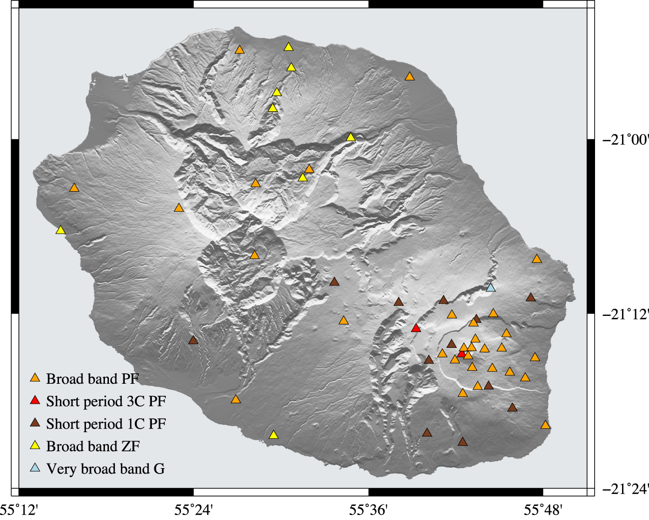
2. Evolution of seismic monitoring systems in La Réunion island
The Piton de la Fournaise Volcano Observatory was created in 1979 following an eruption outside the Enclos Fouqué caldera in 1977 that damaged the village of Piton Sainte-Rose. For decades, the observatory concentrated its seismic instruments on the Piton de la Fournaise volcano, with only a few stations outside the Enclos Fouqué caldera because of the difficulty to transmit data in real time using frequency modulation. At the time, most of the sensors were 1 Hz vertical Mark Product seismometers. Only three stations were equipped with 3-component Mark Product sensors running with Lennartz digitizers. Since 1992, events were detected by an analog LTA/STA and digitized on the hard disk of an HP1000 computer which could handle 200 events of 40 s regularly transferred on magnetic tapes. At the end of 1998, the HP1000 computer failed and the data started to be continuously recorded and analyzed using the Earthworm software [Johnson et al. 1995].
Since 2009, with technical innovations of internet, Wi-Fi, digitizers, and broadband sensors, the observatory was able to significantly extend its seismic network, in particular to cover the eastern flank of the volcano and the periphery of the island. The analog stations have been maintained in case of internet failure and for reference. Today, the seismic network consists of 29 broadband stations, two short period 3-component stations, and 14 analog 1-component vertical stations (cf., Figure 2). This represents a total of 107 channels sampled at 100 Hz transmitted in real time. The conception of seismic stations complies with the following specifications: (1) proofed to cyclonic wind speed, tropical rainfall, and lightening; (2) power self-sufficiency and onsite data backup; (3) minimal environmental impact within the national park; (4) Optimal site noise and thermal insulation. High-availability data streams are sustained via a distributed Wi-Fi network architecture allowing load balancing during temporary local weather-related transmission perturbation. Sensor types are either Guralp CMG or Nanometrics trilium compact posthole, and the digitizers types are Kinemetrics Quanterra Q330 series or Nanometrics Centaur. One of the first station of the Global Network Geoscope (equipped with a STS-1) was also installed in a vault next to observatory in 1982. Due to noisy conditions at the original site, the station was moved on February 1986 in a 4.7 km long tunnel that is part of an hydroelectric facility at Rivière de l’est (RER).
All seismic records are now available in real time. The information to access the data is accessible on the VOLOBSIS portal (http://volobsis.ipgp.fr), and validated data can be accessed through the RESIF data portal (http://resif.fr). Earthquake locations are also available as soon as validated by an operator on the RENASS website (http://renass.unistra.fr/fr/zones/la-reunion). From 1996 to 2012, earthquakes were located using hypo71 modified by Nercessian et al. [1996] to take into account the travel time along the ray to correct for the station elevation, and a 1D velocity model consisting of eight layers [Battaglia et al. 2005c; Nercessian et al. 1996]. Since 2012, earthquakes are located using NonLinLoc software [Lomax et al. 2001] and a velocity gradient following the topography of the island (P wave velocity of 3.3 km/s at the free surface increasing to 8 km/s at a depth of ∼16 km). Since the beginning of 2018, people who felt an earthquake in La Réunion can testify on the website of the French central seismological office (Bureau Central Sismologique Français, http://www.franceseisme.fr).
Over the years, OVPF has supported several temporary seismic deployments such as the UnderVolc broadband network [Brenguier 2014] or the VolcArray project [Brenguier and RESIF 2014]. In the frame of the Rivière des Pluies project [Fontaine et al. 2015a], a temporary seismic network of 11 3-component broadband seismometers was deployed mostly around two rivers of La Réunion Island: Rivière des Pluies and Rivière du Mât. The goal of the project is to monitor spatial and temporal variations of the river’s bed load during tropical cyclones with high-frequency noise. As soon as the data are available on RESIF, local earthquakes are relocated by OVPF using stations from this temporary network.
Figure 1 shows OVPF earthquake locations at the scale of the island from 1996 to 2021. Seismicity outside of Enclos Fouqué caldera represents 7.5% of the total number of earthquakes from 2012 to 2021. These local events occur somewhat continuously and are systematically located if their magnitude is not to low (31% of detected earthquakes are represented on the map). Seismicity within the Enclos Fouqué caldera is associated with Piton de la Fournaise volcano activity and is mostly clustered in swarms of thousands of events during magma intrusions. These volcano-tectonic earthquakes occur mainly above sea level (85.5% of events in La Réunion from 2012 to 2021) but are also located below sea level down to ∼10 km depth (7% of all earthquakes shown in Figure 1).
3. Island-scale seismicity
In this section, we focus specifically on seismicity located under the massif of la Roche-Écrite and in the deep zone between Piton des Neiges and Piton de la Fournaise. The activity of Piton de la Fournaise volcano is addressed separately in Section 4.
3.1. Massif of La Roche-Écrite
Even if volcanic activity at La Réunion island is focused on Piton de la Fournaise, the North flank of Piton des Neiges is also associated with a sustained seismicity (Figure 1). Apart from pre-eruptive seismic swarms under Piton de la Fournaise, the majority of local earthquakes are located between La Roche-Écrite and Saint-Denis (the administrative capital of La Réunion, with 200,000 inhabitants in its metropolitan area). Most felt seismic events in La Réunion are actually located within that area. Until recently, very few seismological stations were installed in the north of the island, resulting in hypocenter location errors of several kilometers. Despite such uncertainties, observations suggest fairly deep locations (depths ranging between 5 and 20 km), indicating that seismic events are probably located in the oceanic lithosphere below the volcanic edifice [see velocity models by Gallart et al. 1999; Fontaine et al. 2015b]. These events are roughly aligned along a plane dipping to the northeast (See cross-section A′–B′ in Figure 1).
Given the relatively poor data coverage in the northern part of the island, it is unclear if this persistent seismicity is of tectonic or of volcanic origin. Michon et al. [2015] proposed that these seismic events result from an extensional stress field maintaining the lithosphere close to failure. This interpretation however relies on poor event locations with no focal mechanism determination. Alternatively, deep seismic events in the oceanic crust beneath Hawaii have been previously interpreted as the rupture of the oceanic crust due to the load exerted by large volcanic edifices [Got et al. 2008]. To better monitor seismicity below the North flank of Piton des Neiges, the volcano observatory started to deploy additional seismological stations in the region. In addition, recent years have benefited from a temporary deployment to monitor river activity [Fontaine et al. 2016] that can be used to better constrain the spatial and temporal distribution of earthquakes.
Seismic activity between 1996 and 2021 at Piton de la Fournaise. Black dots are earthquakes detected and located by OVPF in the southeast of La Réunion island from March 1996 to January 2021. (a) Projection of hypocenters onto an east–west cross-section. Depths of the oceanic crust and underplating are from Fontaine et al. [2015b] and Gallart et al. [1999]. (b) Distribution of earthquakes at depth shallower than 10 km. (c) between 10 and 20 km and (d) between 20 and 30 km. Dashed ellipses in (c) and (d) respectively outline rough seismicity alignments along N120 and N40 trends reported by Michon et al. [2015] and Michon et al. [2016].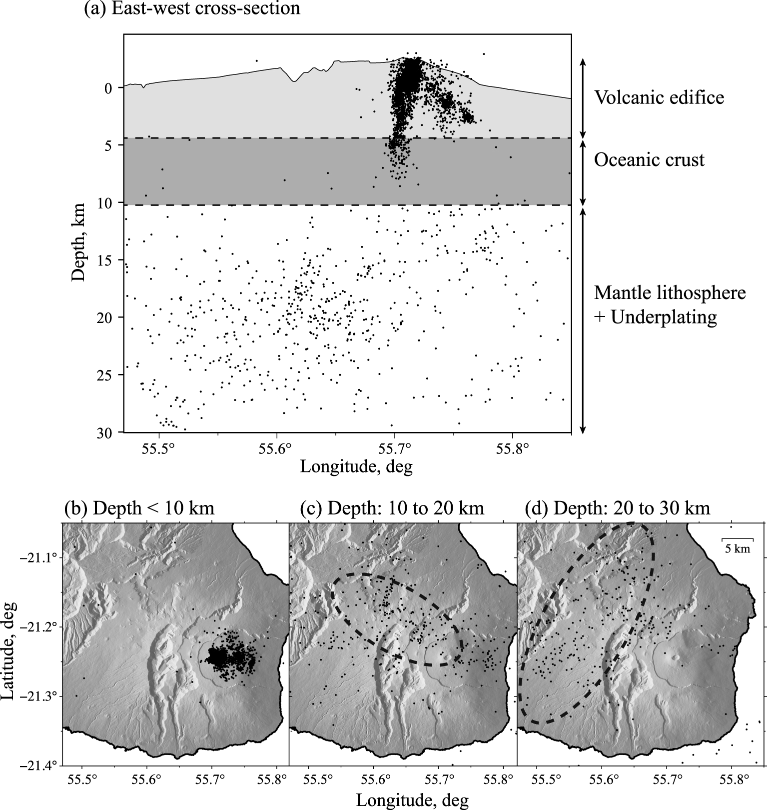
3.2. From Piton des Neiges to Piton de la Fournaise
Moving from La Roche-Écrite to the southeast, we can see on Figure 1 that some local earthquakes are scattered between Piton des Neiges and Piton de la Fournaise at a depth between 11 km and 20 km, corresponding to a region below the oceanic crust [Charvis et al. 1999; Fontaine et al. 2015b]. These events are roughly aligned with a N120° axis (see Figure 3) that corresponds to the main alignment of cinder cones in the area [Michon et al. 2015].
In particular, this deep activity was reported in September 1996 by Battaglia et al. [2005c]. Several earthquakes were detected and located at a depth of ∼16 km, about 10 km north–northwest of the summit of Piton de la Fournaise volcano, during an exceptionally long quiescent period of the volcano (5.5 years). These earthquakes preceded a shallower seismic crisis below the summit in November 1996 that ended with the reactivation of the volcano in 1998 (see Section 4.2). In 2014, Boudoire et al. [2017] report that earthquakes in the same area also preceded the resumption of eruptive activity after a quiescent phase of 41 months. These earthquakes likely occur under a zone of underplating at a depth of 10 to 15 km below seal level [bsl; Gallart et al. 1999].
At a deeper level, between 20 and 30 km, earthquakes follow a trend that is roughly orthogonal to the former N120° [i.e., N40°, see Figure 3; Michon et al. 2015, 2016]. It should be noted that immediately after the main collapse of Dolomieu caldera in April 2007, the seismicity migrated from sea level to about 7 km depth and that the deflation of the summit of Piton de la Fournaise, which started with the eruption of March 30, continued until June 2008 [Massin 2009]. From August 22, 2007, a swarm of events occurred in the southern part of the N40° zone. During this sequence, a magnitude Md = 3.6 mainshock on August 24 at 11:19:32TU located at a depth of 25 km, was felt throughout La Reunion Island [Massin 2009]. The observed seismicity migrations suggest a link between the seismic activity that takes place down to depths of 25 km bsl and the eruptive activity of Piton de la Fournaise volcano.
Volcano-tectonic activity within Enclos Fouqué caldera. We show earthquakes detected and located by OVPF within the Enclos Fouqué caldera from March 1996 to January 2021. (a) Earthquake depth as a function of time. (b) Cumulative number of earthquakes. (c) Frequency-Magnitude distribution of earthquakes. (d) Stacked evolution of pre-eruptive seismicity. Following Collombet et al. [2003], the average time evolution of seismicity rate is obtained by stacking all 66 pre-eruptive sequences between 1998 and 2020 in the time range between 300 days and 2 min before eruption onsets. Gray shaded areas in (a) and (b) represent eruptive periods.
4. Piton de la Fournaise
4.1. Shallow volcano-tectonic seismicity
A review of geophysical and geochemical observations near the main volcanic cone is presented by Peltier et al. [2009] and Roult et al. [2012]. Here, we summarize seismic observations introduced in these articles and update their conclusions with the most recent seismovolcanic activity. From 1996 to 2021, more than 11,000 volcano-tectonic (VT) earthquakes have been detected and located by the OVPF within the Enclos Fouqué caldera (Figure 4). Based on reported duration magnitudes estimated using the approach of Lee et al. [1972], the size of these shear-failure events do not exceed magnitudes 3.0 (cf., Figure 4c). Most earthquakes occur at shallow depth under the Dolomieu summit caldera, just above the expected location of a shallow magma reservoir [Nercessian et al. 1996; Peltier et al. 2008; Prôno et al. 2009]. By combining template matching and double-difference relocation, Lengliné et al. [2016] and Duputel et al. [2019] showed that this shallow activity form a ring-shaped structure gently dipping toward the east (see Figure 5). This structure certainly corresponds to a ring-fault system hosting repetitive collapses of the submit caldera. In Figure 5b, we notice secondary seismicity alignments inside the main ring structure, which might outline secondary faults or weak structures associated with the different collapsed areas that affected Dolomieu and Bory craters in the past [Michon et al. 2013; Duputel et al. 2019; Derrien et al. 2020].
Relocated shallow summit seismicity at Piton de la Fournaise. (a) Map view of ∼16,000 relocated earthquakes (black circles) and eruptive fissures of eruptions between June 2014 and July 2018 (red lines). (b) Map view of relocated earthquakes in four different depth intervals (“elv” stands for elevation above sea level in meters). (c) Projection of relocated events onto an east–west cross-section. Topography at latitude −21.45° is shown for reference. The overall ring-shaped structure has an eastward dipping angle of ∼20°. Figure modified from Duputel et al. [2019].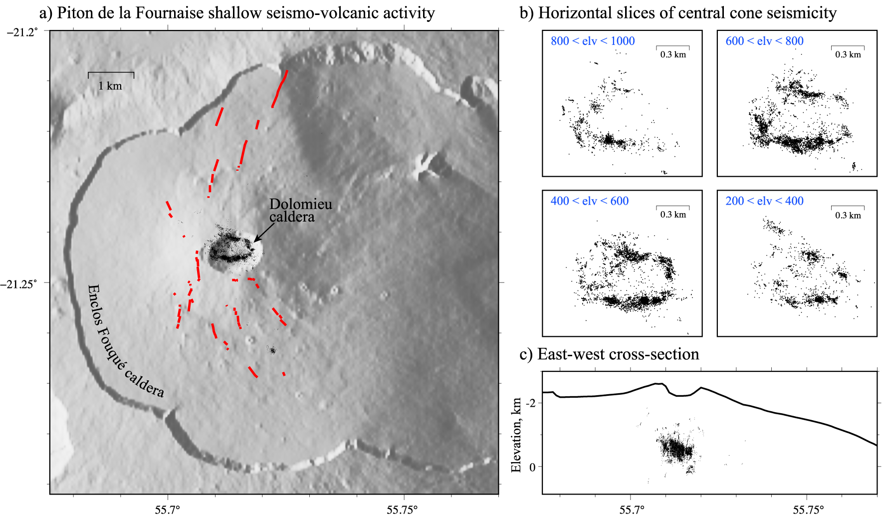
Summit and East flank seismicity at Piton de la Fournaise since January 2019. Map of Piton de la Fournaise volcano showing epicenters of earthquakes detected and located by OVPF from January 2019 until January 2021. Hypocenters are projected onto east–west and north–south cross-sections shown respectively at the bottom and left side of the figure.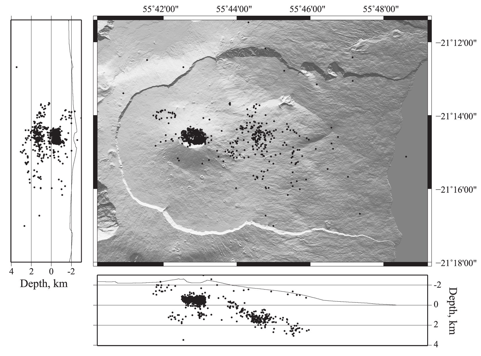
Volcano-tectonic seismic activity is mostly clustered in time during pre-eruptive periods forming intense seismic swarms that typically last from a few tens of minutes to several hours. Apart from these pre-eruptive phases, a low background seismic activity is present, and we can evidence a few seismic swarms not followed by any eruption, corresponding to intrusion episodes also evidenced by deformations of the edifice [Roult et al. 2012]. As observed by Collombet et al. [2003], the VT earthquake rate tends to increase a few days before the onset of eruptions, but this trend is only observed after stacking multiple pre-eruptive sequences and is not always observed for individual eruptions [except for the 1998 eruption; Lengliné et al. 2008]. Figure 4d shows the average evolution of pre-eruptive seismicity for all 66 eruptions that occurred between 1998 and 2020. After an initial increase in seismic activity, the earthquake rate tends to decrease and even sometimes drops to zero, few minutes, or hours before the eruption onset. As proposed by Peltier et al. [2005], Roult et al. [2012], and Duputel et al. [2019], this late and mostly aseismic stage takes place when the magma after migrating vertically from the shallow magma reservoir is transferred horizontally through the edifice. The longer is this quiet period before the eruption onset, the farther the eruptive fissure is from the summit [Aki and Ferrazzini 2000; Roult et al. 2012; Duputel et al. 2019]. This hypothesis is in agreement with recent observations of Duputel et al. [2019], which show that the last visible VT events at the summit are usually located in the direction of the future eruptive site. Although only few earthquakes are evidenced during this lateral magma transfer, Taisne et al. [2011] showed that the seismic signal can still be exploited to track magma migration. A careful analysis of seismograms just preceding the 2010 eruption reveals that high-frequency events are indeed occurring and indicative of magma transfer [De Barros et al. 2013]. These events are difficult to locate as they have no clear arrival onset except at the closest station to the magma source. A rough estimate of their position can be obtained using the signal amplitude decay away from the excitation source [Battaglia and Aki 2003; Taisne et al. 2011], which confirms they track the transport of magma.
Deep volcano-tectonic earthquake migrations in 1998 and 2015. (a) Pre-eruptive seismic activity prior to the eruption on March 9, 1998. (b) Pre-eruptive seismic activity prior to the eruption on May 17, 2015. Top subplots show hypocenter depths as a function of time. Bottom subplots are east–west cross-sections of the event locations in which the colors indicate the earthquake occurrence times. The approximate location of the shallow magma reservoir is indicated with dashed gray lines. Earthquake locations are from Battaglia et al. [2005c] and Lengliné et al. [2016], respectively, for 1998 and 2015 eruptions. We observe that the vertical migration speed is different in both cases.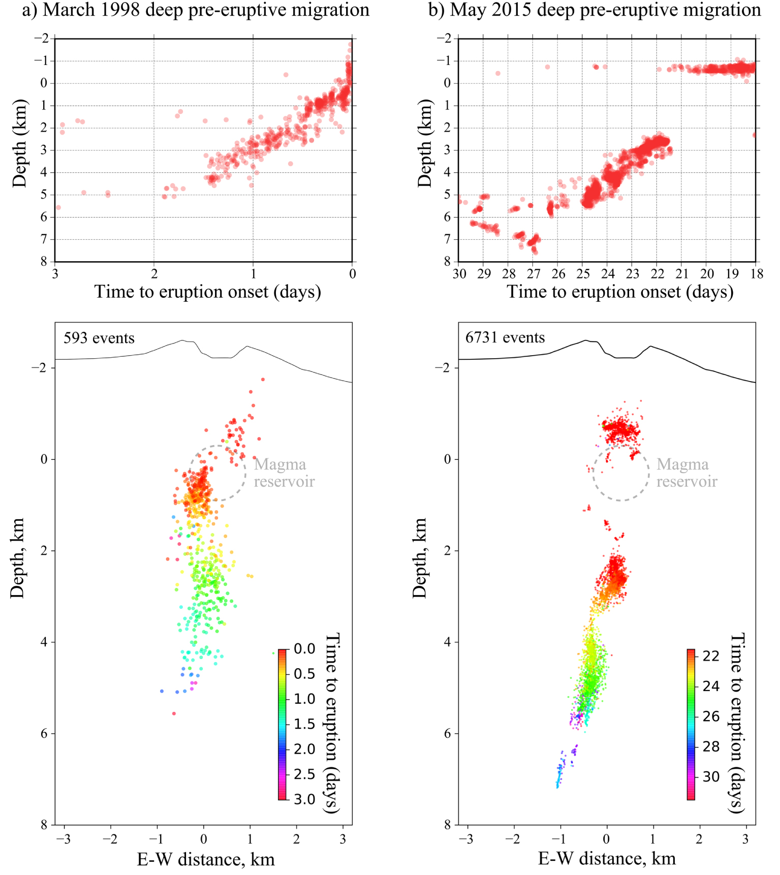
The 2007 Piton de la Fournaise summit caldera collapse. (a) Seismovolcanic context. The April 2007 collapse occurred in the Dolomieu caldera located at the summit of the volcano. The eruptive fissure of April 2007 is indicated with an orange line and the corresponding lava flow is outlined in dark gray. Yellow triangle indicates the location of station RER (waveform shown in e). Black circles are relocated events of Massin et al. [2011] from February 2007 to May 2008. (b, c) are photographs of the Dolomieu caldera before and after the collapse taken by OVPF from the east of the summit looking to the west. (d) A schematic diagram of the piston source model used to explain VLP signals presented in (e) and (f). Black circles are relocated earthquakes from Massin et al. [2011] also shown in (a) projected along a north–south cross-section. (e) Near-field vertical displacement waveform at station RER (after deconvolution to displacement and band-pass filtering in the period range of 5–100 s). (f) Examples of Teleseismic records of the 2007 collapse. These seismograms were deconvolved to displacement and band-pass filtered in the period range of 20–50 s. P wave and S wave arrivals are indicated along with station azimuths (𝜙) and epicentral distances (𝛥). Figure modified from Duputel and Rivera [2019] and Fontaine et al. [2019].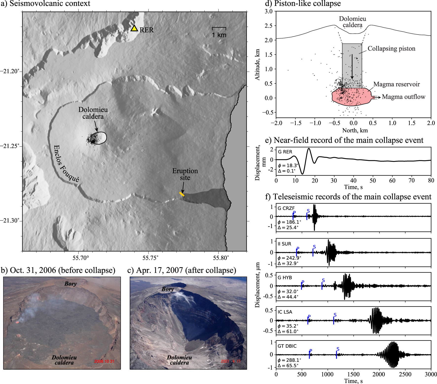
Apart from the seismicity clustered in the vicinity of the Dolomieu summit crater, a sporadic activity is observed below the East flank of the volcano. This East flank activity is shown in Figure 6 and is also visible in Figure 3a. The OVPF catalog contains 576 earthquakes with longitude greater than 55.725° and at a depth shallower than 8 km. A large part of this East flank seismic activity occurs at a depth between sea level and 3 km bsl during magma intrusions. Location of these earthquakes suggest a possible alignment on a structure dipping east. It is tempting to relate these events to a possible structure accommodating the eastward displacement of the volcano [Brenguier et al. 2012; Got et al. 2013; Peltier et al. 2015]. A similar decollement plane is observed at Kilauea volcano, which is activated by the weight of the volcano and pressure in the magma storage system [Got and Okubo 2003].
4.2. Deep volcano-tectonic seismicity
Although most eruptions are preceded only by shallow seismicity, deep seismic activity is occasionally detected between sea level and 8 km bsl. This deep seismicity was particularly active during two seismic swarms that preceded eruptions in 1998 and 2015, reported by Battaglia et al. [2005c] and Lengliné et al. [2016]. In both cases the seismicity started migrating from ∼6 km bsl, at the base of the volcanic edifice where a possible deep magma reservoir is present [Peltier et al. 2009; Michon et al. 2016]. The location of earthquakes shown in Figure 7 evidence clear upward migrations a few km west of the Dolomieu crater for both 1998 and 2015 eruptions. After these vertical migrations, seismic events move east before reaching the shallow magma reservoir located around sea level (Figure 7). Although the depth range of event locations is similar between these two episodes, the time scale is clearly different. In 1998, this migration occurred over less than 3 days, and the eruption started immediately after the occurrence of earthquakes near sea level. More than 3000 events were recorded and 700 of them had a magnitude Md⩾1.5. In 2015, the migration was much slower and discrete, with magnitudes barely reaching 0.7, and was followed by a period of intense shallow seismicity for 21 days before the eruption onset.
Both earthquake migrations are interpreted as markers of magmatic recharge of the shallow reservoir from a deeper source [Battaglia et al. 2005c; Lengliné et al. 2016]. The two episodes marked the reactivation of Piton de la Fournaise activity following long phases of quiescence (from 1992 until 1998 and from 2010 to 2014). The fact that both migrations are immediately followed by shallow seismic activity ultimately leading to eruptions suggest a hydraulic connection between shallow and deeper part of the plumbing system. This interpretation is supported by geodetic observations indicating the upward migration of a deep pressure source in 2015 [Peltier et al. 2016]. This is also consistent with geochemical and petrological observations suggesting that both episodes correspond to magma rejuvenation in the shallow part of the plumbing system [Boivin and Bachèlery 2009; Coppola et al. 2017].
4.3. The April 2007 caldera collapse
In April 2007, Piton de la Fournaise experienced a large caldera collapse that resulted into a depression of ∼330 m in the Dolomieu summit crater (Figure 8). Although such events have occurred frequently in the history of Piton de la Fournaise [Michon et al. 2013], it is the largest caldera collapse reported in La Réunion since the 18th century. The collapse was immediately preceded by three subsequent eruption phases that were associated with a single inflation–deflation cycle possibly marking a deep magma input pressurizing the shallow magma reservoir [Fontaine et al. 2014]. This eruptive sequence ended up with a lateral low-altitude eruption on April 2, 2007, with exceptionally high flow rate and a large volume of ejected lava [Figure 8a; Staudacher et al. 2009].
The surface collapse activities started on April 5, 2007, at 20:48:43 UTC after several days of intense seismic activity below the summit and the eastern flank of the volcano (Figure 8a,d). In particular, this activity consisted of numerous compensated linear vector dipole (CLVD) earthquakes from April 1st to 5th with a subvertical compressive axis suggesting the closure of horizontal cracks in the rock column above the magma reservoir [Massin et al. 2011]. Such intense seismicity probably reveals subsurface fracturing above the magma reservoir in response to the onset of magma outflow as suggested by numerical modeling [Holohan et al. 2017]. The last 20 hours before the caldera collapse were also marked by several very-long-period (VLP) signals with frequencies in the range 0.003–0.5 Hz accompanied by tilt increments [Fontaine et al. 2019; Duputel and Rivera 2019]. Fontaine et al. [2019] proposed that these tilt and VLP precursors correspond to the initiation of the collapse at depth before the onset of surface subsidence. The small size of these precursors and their waveform differences with the VLP events observed during the main collapse suggest that most of the collapsing rock column remained locked in the early stages of the sequence [Duputel and Rivera 2019]. Precursory deep collapses have been reported previously during the 2000 Miyake-jima caldera collapse [Kobayashi et al. 2012]. Such deep nucleation is also predicted by some analog experiments and numerical models [e.g., Roche et al. 2000; Holohan et al. 2017]. However, as pointed out by Geyer and Marti [2014], there are significant discrepancies when comparing existing analog and numerical results, depending on the experimental setup and the assumed mechanical properties of both the host rock and the magma chamber. In addition, while pre-existing ring structures can significantly affect the collapse dynamics [Ruch et al. 2012], most studies assumes previously intact host rock contrarily to what is observed at Piton de la Fournaise [Sapin et al. 1996].
The 2007 collapse at Piton de la Fournaise consisted in a quasi-periodic series of 48 discrete collapse events from 5 April until 14 April. As observed at other basaltic calderas [Kumagai et al. 2001; Michon et al. 2011; Segall et al. 2019], these collapses were accompanied by inflationary tilt steps and by the emission of VLP seismic signals [Fontaine et al. 2019; Duputel and Rivera 2019]. The first event on 5 April is the largest collapse of the sequence with a moment magnitude MW = 5.4 [Duputel and Rivera 2019], which makes it the largest seismic event ever recorded below La Réunion island. Teleseismic observations of the first collapse shown in Figure 8f can be well explained by a crack-like moment tensor source [Fontaine et al. 2019; Duputel and Rivera 2019]. Near-field records at the Geoscope station RER (shown in Figure 8e) suggest that this closing crack source should be complemented by a vertical single force [Duputel and Rivera 2019]. In this joint model, the single force is directed initially upward and later downward, consistently with the sudden descent of a massive rock piston in the magma reservoir. The closing tensile crack source corresponds to the contraction of the magma reservoir due to the collapsing piston. For the entire collapse sequence, moment magnitude estimates range from MW = 4.4 to MW = 5.4 with source durations ranging from 6 s to 14 s, which is significantly longer than what is typically observed for tectonic earthquakes of similar sizes [durations ranging from 0.6 to 2 s for similar magnitude earthquakes; Duputel et al. 2013]. Such anomalously long source durations have been reported for other caldera collapses [Shuler et al. 2013]. This reveals that the dynamics of caldera collapse events are different from regular earthquakes. Observations at Piton de la Fournaise indicate that the collapse is primarily controlled by magma withdrawal from the shallow reservoir and that the duration of each collapse event is likely controlled by different parameters such as the geometry of the collapsing piston, the volume of the magma reservoir, and the bulk modulus of the magma [Duputel and Rivera 2019].
5. Discussion and conclusion
Seismic events in La Réunion island are distributed over three main seismogenic areas: (1) The massif of La Roche-Écrite, (2) The region between Piton des Neiges and Piton de la Fournaise, and (3) the Piton de la Fournaise volcano. In regions (1) and (2), at the northeast of Piton de la Fournaise, earthquakes generally occur below the volcanic edifice within the oceanic lithosphere. In contrast, seismicity at Piton de la Fournaise is mostly confined to the volcanic edifice.
Volcanic activity at Piton de la Fournaise is producing the largest part of the seismicity of La Réunion island. Within the Enclos Fouqué caldera, most earthquakes occur on a ring-fault system just above a shallow magma reservoir located around sea level (Figure 5). These volcano-tectonic events are often clustered in intense seismic swarms during magma intrusions and are used as indicators of impending eruptions [e.g., Roult et al. 2012; Duputel et al. 2019]. Below sea level, we detect episodic upward seismicity migrations starting from ∼6 km bsl (Figure 7). These vertical migrations correspond to magmatic recharges of the shallow reservoir from a deeper magma source. Such episodes have been well captured in 1998 and 2015 after long phases of quiescence in eruptive activity [Battaglia et al. 2005c; Lengliné et al. 2016]. Both migrations have been preceded by even deeper seismic activity northeast of the Enclos Fouqué caldera between the Piton des Neiges and the Piton de la Fournaise (Figure 1). These earthquakes at a depth larger than 10 km are likely markers of magma transfer from the deepest parts of La Réunion plumbing system, in a zone of underplating suggested by a seismic transect acquired across the island in 1993 [Gallart et al. 1999].
A major event that affected Piton de la Fournaise is the caldera collapse of April 2007, which deepened the summit caldera floor by more than 300 m. As observed at other basaltic calderas, this collapse manifested as a quasi-periodic series of discrete subsidence events, releasing VLP signals equivalent to MW = 4.4 to MW = 5.4 earthquakes [Fontaine et al. 2019; Duputel and Rivera 2019]. Source analysis of VLP events suggests a piston-like mechanism combining the descent of a massive rock piston in a contracting magma reservoir. Similar to the 2018 Kilauea summit caldera collapse, observations at Piton de la Fournaise include a reduction of the time interval between successive collapses, which likely results from the acceleration of magma withdrawal and a progressive weakening of the volcanic edifice [Duputel and Rivera 2019].
As it is often the case on volcanoes, a wide variety of seismic signals is recorded in La Réunion island. Besides volcano-tectonic and VLP events, other signals that have not been discussed in this article include volcanic tremor, long-period (LP) events, and rockfalls. Volcanic tremor at Piton de la Fournaise is usually relatively broadband and is thus often referred to as non-harmonic tremor [Battaglia et al. 2016]. In general, tremor starts as soon as the eruptive fissure reaches the free surface allowing the gases and magma to escape. Tremor is rarely observed without any surface activity, except at a few occasions. For example, following an intense seismic swarm on May 17, 2017, a tremor was observed during 4 h on the north flank, but only gases were released, leaving no trace of an eruption. Sharper spectral peaks than in the case of an eruptive tremor was the only difference observed compared to regular eruptions. Gases constitute the main source of volcanic tremor. Although a crack emitting a completely degassed lava could go unnoticed, the start and end times of an eruption is conventionally defined using tremor observations. The location of the eruptive sites can also be derived using observed tremor amplitudes [Battaglia et al. 2005a,b; Journeau et al. 2020]. Long-period events usually manifest as a sharp broadband onset followed by a coda of decaying harmonic oscillations with typical frequencies between 0.5 and 5 Hz [Chouet and Matoza 2013]. Long-period seismicity is surprisingly rare at Piton de la Fournaise compared to other volcanoes. For instance, Aki and Ferrazzini [2000] identified only 800 LP events from 1981 to 1992 while thousands of LP signals can be recorded in a few months on other volcanoes [e.g., Battaglia et al. 2003; Shapiro et al. 2017]. Zecevic et al. [2013] suggests that LP events observed at Piton de la Fournaise correspond to the closure of hydrothermal cracks located a few hundred meters below the summit area. The scarcity in LP events could then be explained by an underdeveloped hydrothermal system and the fact that tensile crack sources are limited to very shallow depth under the summit. At Piton de la Fournaise, numerous rockfalls occur in the Dolomieu summit caldera. This is particularly true since the April 2007 collapse, which exposed vertical rockwalls that are prone to frequent rockfalls [Hibert et al. 2011]. Largest rockfalls seem to be often triggered by pre-eruptive volcano-tectonic seismicity combined with the action of rain [Durand et al. 2018]. Massive rockfalls also occur at other locations in the island such as the 1965 Mahavel episode (30 × 106 m3) a few kilometers east of the Enclos Fouqué caldera that was associated with frequent subsequent rockfalls corresponding to millions of cubic meters of material between 1996 and 2001 [Rousseau 1999; Hibert et al. 2017].
While earthquakes in volcanic edifices are mostly related to stress perturbations caused by volcanic processes at various scales, the link between these seismic events and the stress source is often difficult to make. For example, the origin of episodic seismicity occurring below the East flank of Piton de la Fournaise volcano is still unclear. Earthquake locations shown in Figure 6 suggest that they are located on an eastward dipping structure that is possibly accommodating seaward flank displacements as observed at other basaltic volcanoes. Such ruptures are particularly active during eastward intrusions generating large flank displacements, which might be promoted by gravitational forces. However, considering the April 2007 eruption and caldera collapse, a discrepancy remains between the inverted depth of the structure participating to the eastward displacement of the volcano, as inferred from InSAR images [380 m depth; Tridon et al. 2016], and the depth of East flank earthquakes (from sea level down to 3 km bsl, Figure 6). A large part of the observed displacements might be due to plastic response of the East flank [Got et al. 2013], which could complicate the identification of a decollement fault or a sheared sill assuming a linear elastic medium.
Another question related to La Réunion seismicity is the origin of the active seismic cluster under the massif of La Roche-Écrite (Figure 1). This is particularly important as most earthquakes felt locally are located in that area, which is close to the densely populated administrative capital of the island. Seismic events in La Réunion may have multiple causes, such as magma intrusions, tectonic constraints, or gravitational loads. Hypocenter locations shown in Figure 1 suggest a north-eastward dipping plane within the oceanic lithosphere below the volcanic edifice. However, the poor station coverage might significantly bias event locations in the region. Seismic stations are currently being deployed to better constrain seismic events in the region. In addition, improved detection and relocation techniques are currently underway along with the determination of focal mechanisms. These additional observations are essential to better understand the mechanisms triggering seismicity beneath the North flank of Piton des Neiges.
Acknowledgments
We thank Aline Peltier for enlightening discussion. Information to access OVPF data is available on the VOLOBSIS portal (http://volobsis.ipgp.fr). Validated data can be accessed through the RESIF data portal (http://resif.fr). OVPF earthquake locations are available on the RENASS website (http://renass.unistra.fr/fr/zones/la-reunion). This project was supported by the European Research Council (ERC) (under the European Union’s Horizon 2020 research and innovation program under grant agreement No. 805256). This study also benefited from support from the Research Federation Observations des Milieux Naturels et des Changements Globaux (OMNCG) and Observatoire des Sciences de l’Univers - Réunion (OSU-R) at University of La Réunion, the Région Réunion and the CNRS-INSU (Institut National des Sciences de l’Univers) funding from the TelluS-SYSTER and TelluS-ALEAS programs. We would like to acknowledge the INSU-RESIF/SISMOB for providing five seismic stations deployed in the “Rivière des Pluies” network http://dx.doi.org/10.15778/RESIF.ZF2015. Seismic data will be available at the French RESIF archive center (http://seismology.resif.fr) under the ZF experiment code [Fontaine et al. 2015a]. This study has been also supported by the ReNovRisk-Erosion FEDER project funded by the Région Réunion and European Community. Thanks to the University of La Réunion and the Laboratoire GéoSciences Réunion for their supports. We thank the editor Frédéric Masson and two anonymous reviewers for their comments, which helped us improve this manuscript. This is IPGP Contribution Number 4236.