

1 Introduction
Beds of Posidonia oceanica (L.) Delile, an endemic species of the Mediterranean, constitute one of the most important ecosystems of the Mediterranean [1,2]. Powerful integrators of the average quality of coastal waters [3], European Directive Habitats (92/43/CEE of May 21, 1992) have designated them as priority habitat and therefore they are under legal protection in many Mediterranean countries [4]. More recently, under the United Nations Environment Program, an action plan for the conservation of the marine vegetation in the Mediterranean was adopted by all the countries involved [5]. Posidonia oceanica beds are especially concerned with this action plan, as much as a species as the ecosystems they constitute [6]. The adopted strategy in this action plan relies in particular on the completion of reference status inventories and mapping; and on the organisation of long term monitoring (inspection networks) of these habitats.
The use of Posidonia oceanica as a biological indicator of the environmental quality is the subject of many studies as much with regards to the plant itself (accumulation of stable pollutants, synthesis of detoxification enzymes, foliar biometrics) as with the beds (density, covering, type and position of the lower limits) [7–10]. These describing factors are often standardized; interpretation scales have been validated and are regularly used by many authors [11,12]. Among these factors, the bathymetric position of the lower limit of the beds is especially important, since it records any deterioration, however minute, of the average water quality and more particularly of turbidity. In fact, any decrease in water transparency and thus of the light level results in an upward movement of this limit and therefore in a regression of the seagrass bed [12]. The study protocol which makes it possible to follow the evolution of the position of the lower limits by the installation of permanent structures on the bottom, was initiated by Meinesz [13]. Ever since, this technique has been widely used around the Mediterranean with the setting up of monitoring networks of Posidonia oceanica beds [14].
However, this technique requires the regular maintenance of the immersed structures, sometimes even their replacement when too severely damaged (damage by trawlers; sedimentary movements; high water movement) [8]. Besides, their installation on rocky substrates imposes technical and financial constraints often quite incompatible. This is the reason why only very few such markings exist on this type of substrates and little information is available on the evolution of the lower limit of the seagrass beds in the concerned areas [15]. Similarly, ‘sand tides’ responsible for the burying of these structures can be observed in several areas with the resulting increase in maintenance frequency or even a loss of data related to the disappearance of markings [16]. To lessen these difficulties, acoustic telemetry could constitute an interesting alternative solution for the marking of seagrass beds' lower limits. In fact, this technique, based on the acoustic principle of interferometry on short bases, does not imply the installation of permanent structures, but only the identification of a small number of points that can be natural (rock features). In order to test the potentialities of this system, an experiment was carried out on a Posidonia oceanica bed located in the marine reserve of Banyuls–Cerbère (eastern Pyrenees, France).
2 Materials and methods
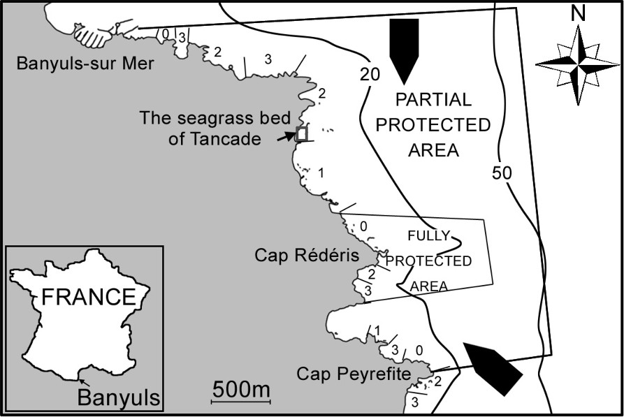
The natural marine reserve of Banyuls–Cerbère extends on 650 ha along the rocky shoreline of the Albères coast (Fig. 1). The intensity and the frequency of strong gales are particularly high: one day out of three, the area experiences winds higher than 50 km h−1 [17]. In this area, the Posidonia oceanica bed is subjected to very difficult abiotic conditions and often undergoes a regressive dynamic [18–20]. The seagrass bed of Tancade, particularly under stress, is located in the northern part of the Marine reserve near Cape Abeille [21]. The growth of this bed is monitored by the use of a local underwater positioner AQUAMETRE D100 (PLSM, Paris, France), using the principle of interferometry acoustics on short bases (Fig. 2). The acoustic positioner is composed of the following elements:
- – a measuring base made up of an interferometric framework assembled at the end of a mast and an electronic case allowing communication with a computer at the surface. The interferometric framework is a very rigid structure supporting four hydrophones detecting the ultrasonic pulse emitted by the pointer (three-dimensional localization);
- – a mobile pointer with build-in keyboard and liquid-crystal display, allowing scuba divers to point at the objects to be positioned and store the data in memory. The pointer is equipped with a transducer/receiver hydrophone sending an ultrasonic pulse when questioned by the base.
Localization of the study site including index of shelter from hydrodynamic conditions (Mean water movement is noted from 0 (higher) to 6 (lower) [22]). : Dominant winds.
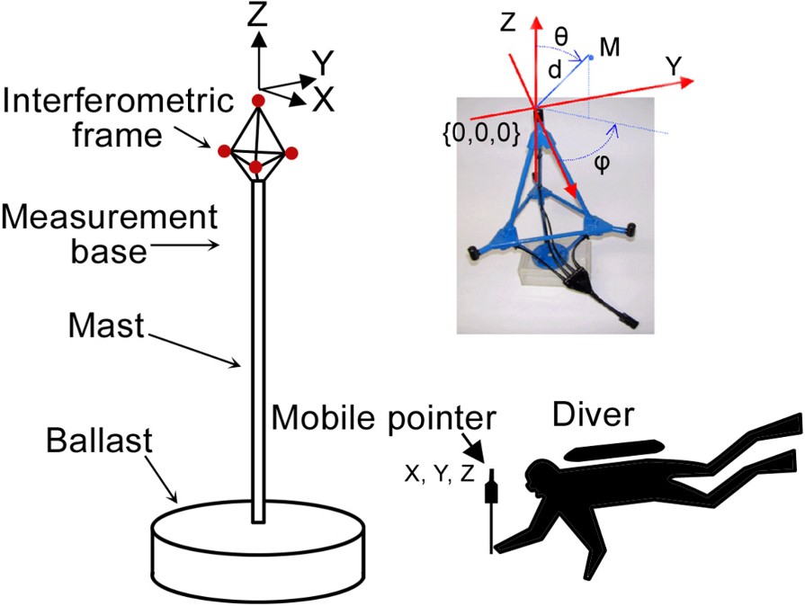
Measurement base and pointer (not scaled). The local Cartesian-coordinate system is associated to interferometric frame. A biaxial inclinometer allows correction of mast inclination up to ±10° in order to always compute coordinate in a coordinate system where the Z-axis is vertical and the X- and Y-axes are horizontal. The origin of the system is the top hydrophone. A point M is given by the distance d from the origin, the azimuth angle ϕ in the horizontal plane, the elevation angle θ from the vertical. Spherical coordinate system. Masquer
Measurement base and pointer (not scaled). The local Cartesian-coordinate system is associated to interferometric frame. A biaxial inclinometer allows correction of mast inclination up to ±10° in order to always compute coordinate in a coordinate system where the Z-axis ... Lire la suite
The maximum range between the pointer and the base may reach 130 m (nominally 100 m); the autonomy of the base and of the pointer is 8 h in active mode. The recordings are stored in a FLASH memory, then transferred by an infrared interface onto a computer (Pentium PC). The angular accuracy of the system is 0.1°. The absolute accuracy of the recordings thus varies with the distance to the base. At a distance of 10 m from the base, accuracy is 1.7 cm. At 100 meters, the accuracy is 17 cm. The recordings of these points at the surface using a Differential Global Positioning System may make it possible to integrate the approximate beacon position in a Geographical Information System. Once the base has been positioned on a remarkable feature, easy to locate, approximately at the centre of the lower limit to be mapped, it is turned on together with the pointer (autotests, calibration, adjustment of the acoustic reception level, sampling). During the monitoring of the lower limit, the following data are recorded for each point, on underwater slates, in order to draw the bionomic cartography, but also to record specific parameters, such as the presence of outstanding benthic species (Corallium rubrum, Pinna nobilis, etc.) (Table 1).
Example of data recorded while diving on each point
| Identification on substrate | Seagrass bed features | Biocenotic data |
| Rocks and boulders over 30 cm | Seagrass bed on sandy area | Type of P. oceanica limit |
| Shifting rocks (gravels, pebbles) | Seagrass bed on rocky area | (sharp, erosive, regressive...) |
| Sand | Dense seagrass bed | Presence of dead matte |
| Dead seagrass roots | Patchy seagrass beds | Presence of Pinna nobilis |
In order to ensure the most precise long term monitoring, two remarkable points (the highest points of two large rocks) have also been identified and recorded; a basic graphic analysis of the results then makes it possible to visualize the lower limit of the seagrass bed.
3 Results
The graphic interpretation of the groups of dots allows the quick visualization of the outline of the lower limit of the seagrass bed, as well as the height of the points in relation to the beacon (Fig. 3). This is particularly useful to understand long-term sedimentary movements on the site.
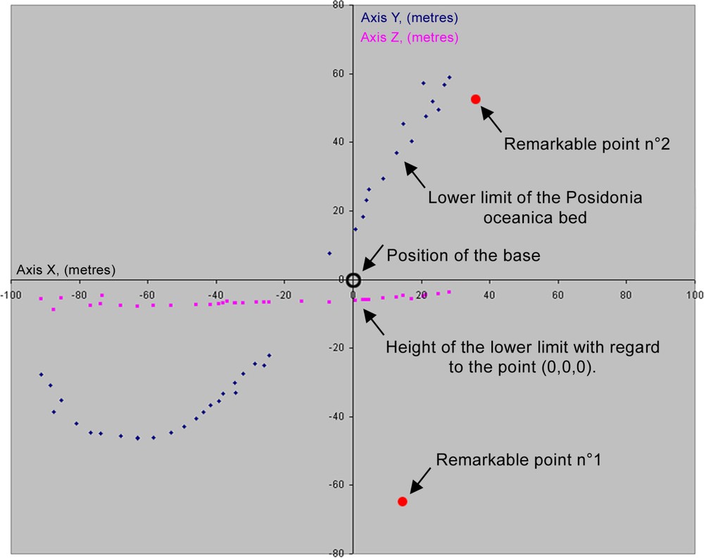
Graphic exploitation of the results obtained along Posidonia oceanica lower limit.
The superposition of biocenotic information and the position of the lower limit make it possible to map the location of the Posidonia oceanica bed (Fig. 4). The surface recording of four points using a differential GPS allows the georeferencing of the outline of the seagrass bed and its integration in a Geographical Information System.
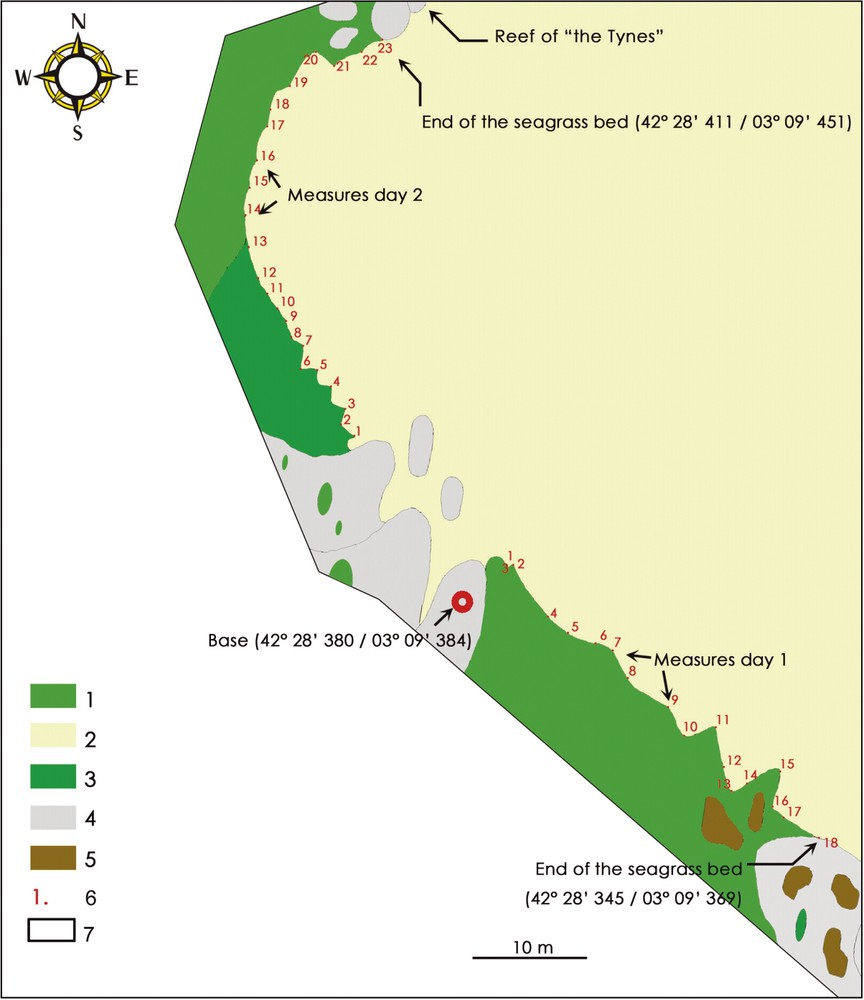
Position of the lower limit of the Posidonia oceanica bed of Tancade. 1: Mosaic of Posidonia oceanica on mobile rock; 2: sand; 3: Posidonia oceanica on sand; 4: permanent markers; 5: dead matte; 6: measured points by telemetry; 7: not studied zone.
4 Discussion and conclusion
The standard technique of permanent buoys for the monitoring of the lower limit of Posidonia oceanica beds quickly turned out to be inadapted, due to the nature of the substrate (5- to 20-cm-thick seagrass matte growth on rocks and boulders making any mooring uneasy), the hydrodynamic condition on the site (frequent storms destroying any immersed structure) and the lack of means making regular maintenance of the structures impossible. Therefore, out of the eleven buoys moored in 1989 on the close-by site L'Anse du pin parasol (yet not as strongly exposed), only three were still in place by 1997 [20] and have since been requiring a costly yearly maintenance for fear of losing any monitoring option. Thus, another method, based on acoustic telemetry, has been experimented with on the site of Tancade. It allows a new referencing of the lower position of Posidonia oceanica bed regarding geographical localisation and depth in an area where the seagrass bed shows a slow growth [23] without any risk of physical destruction of the markers.
Through this first experiment, it is possible to point to the advantages and the disadvantages of this method.
4.1 Advantages
Acoustic telemetry does not require any preliminary knowledge of the study site, is not dependent on the type of substrate or on the hydrological conditions, and makes ship-towed instrumentation unnecessary. This technique is faster than a traditional marking, since there is no need for installing the markings on the sea bottom and a great number of dives (i) are avoided, (ii) neither is it necessary to take bearings and measure distances between markings in order to achieve an accurate mapping of the lower limit. Moreover, it makes it possible to detect possible sedimentary movements, which is impossible with the ‘traditional’ marking method due to the inaccuracy of depth gauges [8]. In fact, acoustic telemetry offers an accuracy of a few centimetres and its reference frame is not the sea level any more (which may vary depending on weather and tidal conditions) but the stable easily identified points (rocky outcrops). Acoustic telemetry can be used for the accurate location and the monitoring of many communities (range limits) or benthic remarkable species (gorgonians, sponges, Corallium rubrum, Pina Nobilis) without any disruption caused by the installation of fixed reference marks.
4.2 Disadvantages
The use of acoustic telemetry requires the referencing and recording of two ‘natural’ points located less than 100 m from the acoustic base. The limited range of the device (100 m range) makes it more suitable for the mapping of small areas (moving the base is possible while preserving the data in the same reference mark, but the accuracy of the recording is then reduced). Acoustics may be affected by particular conditions: strong local variation in temperature (clearly marked thermocline), local variation of salinity and temperature (river estuary, fresh water spring...). Finally, the cost of the device is high and its use requires specific training.
The use of acoustic telemetry seems a very promising technique for the monitoring of the limits of the benthic communities, and in particular of seagrass beds. The possibility of carrying out very accurate mapping offers many potentialities for monitoring networks in the marine environment and more particularly for protected species and ecosystems, but also in the study the competitive dynamics of some species (competition between Posidonia oceanica and Caulerpa taxifolia).