

1 Introduction
Industrial minerals are essential for the development of the world economy, the improvement of infrastructures and the growth of the economic sector. In this category, there are many ways of using clay-rich materials in the manufacture of ceramics and as construction materials. As such, for their efficient exploitation, a good knowledge of their occurrences, quantity and properties is required.
In the Douala sedimentary sub-basin (South-Cameroon, Central Africa), several studies allowed to better understand the stratigraphic and tectonic evolution including Belmonte (1966); Brownfield and Charpentier (2006); Dartevelle and Brebion (1956); Dartevelle et al. (1957); Dumort (1968); Manga (2008); Meyers et al. (1996); Nguene et al. (1992); Njike Ngaha (1984); Regnoult (1986); Reyment (1955a, 1955b, 1956, 1957, 1958); Reyre (1966); Riedel (1932); SNH/UD (2005); Solger (1904); Von Koenen (1896). However, clay deposit researches to set up industrial units in the Douala region for manufacturing construction materials and ceramics began only in 1980 (Thibaut and Le Berre, 1985). During the following exploration several clay deposits were located in the Douala region, among the Bomkoul clayey deposit.
In the Bomkoul area, Njopwouo and Wandji (1985), and Njopwouo and Kong (1986) show the kaolinitic nature of two clayey raw materials identified (grey and mottled clays) by analyzing their chemical and mineralogical compositions. Elimbi and Njopwouo (2002) also showed that clayey raw materials have good firing characteristics for ceramics. Moreover, Njopwouo (1984) studied the use of raw materials in the polymerization of the styrene and in the reinforcement of the natural rubber. However, despite the preliminary works done on the field by Mbog (2010) and Maliengoue (2010) to describe clayey materials of the Bomkoul area, no further geological study was carried out to locate and describe the clayey material outcrops.
To that effect, the objective of this study was to locate and describe the clayey materials and to present their physical, chemical and mineralogical properties so as to discuss the exploitation of the clay occurrences of the Bomkoul deposit.
2 Geological setting
The study area is located in the Douala sub-basin which forms the northern part of the Cameroon's Douala/Kribi-Campo Basin. The Douala sub-basin is located in the Gulf of Guinea between the Cameroon Volcanic Line in the north and the Kribi-Campo sub-basin in the south. It is characterized by a low surface of erosion (< 200 m altitude) which corresponds to interfluves with convex and convexo-concave hillsides joined to narrow and either more or less deep valleys.The lithostratigraphy of Douala sub-basin is made of seven major Formations related to its geodynamic and sedimentary evolution (Nguene et al., 1992; Regnoult, 1986; SNH/UD, 2005). (1) The syn-rift period represented by the Mundeck Formation (Aptian-Cenomanian) is discordant onto the Precambrian basement and consists of continental and fluvio-deltaic deposits, i.e., clays, coarse-grained sandstones, conglomerates. The post-rift sequence includes: (2) the Logbadjeck Formation (Cenomanian-Campanian), discordant onto the Mundeck Formation and composed of microconglomerates, sand, sandstone, limestone, and clay; (3) the Logbaba Formation (Maastrichtian), mainly composed of sandstone, sand and fossiliferous clay; (4) the N’kapa Formation (Paleocene-Eocene), rich in marl and clay with lenses of sand and fine to coarse-grained crumbly sandstone; (5) the Souellaba Formation (Oligocene) lying unconformably on N’kapa deposits and characterized by marl deposits with some interstratified lenses and sand channels; (6) the Matanda Formation (Miocene), dominated by deltaic facies interstratified with volcano-clasties layers; and (7) the Wouri Formation (Plio-Pleistocene) which consists of gravelly and sandy deposits with a clayey or kaolinic matrix.
3 Study area
The Bomkoul area is located to the north-east of Douala region between latitude 4°05′ and 4°06′ N and longitude 9°47′ and 9°49′ E in Douala sub-basin (Cameroon, Central Africa), within a humid equatorial climatic zone. The geomorphology of the study area is a coastal plain with low altitudes (40–120 m). This area shows hills with flat and sharp summits and is deeply incised by V and U shape valleys. According to the geological map of SNH/UD (2005) report, the relative age of the deposit of Bomkoul area is Upper Tertiary Miocene-Pliocene corresponding to the Matanda-Wouri-Formation (Fig. 1).
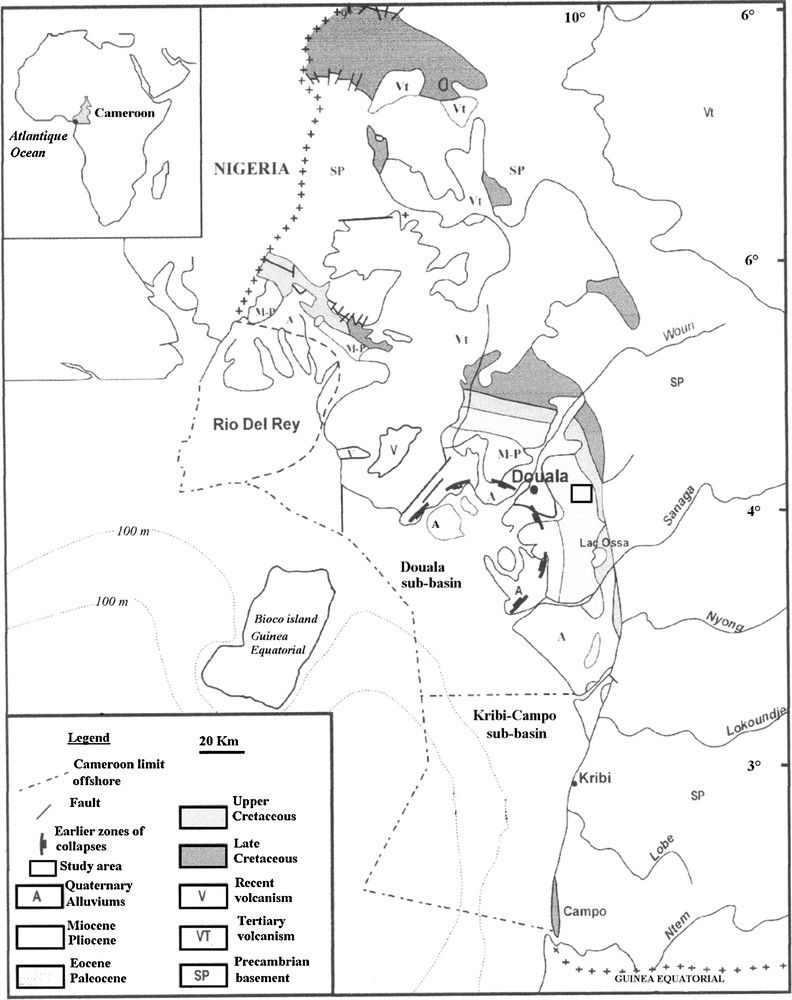
Geological sketch map of Douala sub-basin (SNH/UD, 2005).
Carte géologique du sous-bassin de Douala (SNH/UD, 2005).
4 Material and methods
Systematic sampling of sediments from various geomorphic surfaces was done from a total of thirteen wells and two drillings with a distance of 100 m between sampling locations. Only five sediment profiles, representative of geomorphological and geological settings were selected for this study. A geological survey allowed describing the characteristics (color using Munsell Soil color chart, texture, and structure) and distribution (clayey levels of the upper, middle and lower slopes) of four clayey profiles, and one sand and sandstone profile. Facies were classified using Miall (1996) and Postma (1990) classification.
A total of 16 clayey samples corresponding to 16 facies were collected from the four clayey profiles. Various analyses were performed on the samples collected for basic parameters (pH, OM, nitrogen, and particle size) as shown in Table 1, and mineralogical and chemical data. Elemental analyzers (Elemental-analysator CNS, Vario EL, Gallenkamp digital flame analyser) were used to measure carbon and nitrogen contents in samples dried (40 °C) and grounded with an agate mill. Clay material pH was measured with a combined electrode in water and potassium chloride (1 M) at a clay material:solution ratio of 1:2.5 (Schlichting et al., 1995). To measure the particle size distribution, air dried and sieved (2 mm) clay samples of fine sediment (50 g of 2 mm clay fraction) were previously treated with H2O2 to remove organic matter and mechanically agitated for 8 h with Na-hexametaphosphate N/1000. The particle size measurement was carried out in two steps: (i) a conventional sieving for the 63 to 2000 μm fractions; (ii) using a sedigraph 5000 in automatic procedure for clay and silt fractions.
Propriétés basiques des argiles des profils P3, P4, P9 et P13.
| Profile | Depth | Texture | Colour | Particle size | pH | Organic matter | |||||
| (cm) | Sand | Silt | Clay | H2O | Kcl | C Wt% |
N Wt% |
OM Wt% |
|||
| P3 profile (lower slope) |
|||||||||||
| L4 | 160 | Silty-clay | Mottled | 17.7 | 26.0 | 55.4 | 4.6 | 4.5 | 2.9 | 6.0 | 5.0 |
| L3 | 470 | Silty-clay | Mottled | 15.6 | 26.1 | 56.7 | 2.2 | 2.0 | 1.6 | 0.5 | 2.8 |
| L2 | 660 | Clayey-silt | Dark grey | 43.7 | 33.9 | 21.2 | 2.2 | 2.0 | 1.9 | 0.4 | 3.3 |
| L1 | 800 | Clayey-silt | Dark grey | 28.1 | 53.6 | 18.2 | – | – | – | – | – |
| P4 profile (middle slope) |
|||||||||||
| S4 | 185 | Clay | Mottled | 22.9 | 12.1 | 53.7 | – | – | – | – | – |
| S3 | 285 | Silty-clay | Mottled | 23.3 | 25.3 | 50.2 | 3.4 | 3.8 | 1.2 | 0.4 | 3.5 |
| S2 | 640 | Clay | Grey | 17.7 | 27.0 | 54.6 | – | – | – | – | – |
| S1 | 1100 | Silty-clay | Grey | 8.3 | 41.1 | 49.5 | 6.5 | 6.1 | 3.2 | 0.6 | 5.4 |
| P9 profile (upper slope) |
|||||||||||
| R4 | 1125 | Silty-clay | Mottled | 22.3 | 36.1 | 38.4 | – | – | – | – | – |
| R3 | 1325 | Silty-clay | Grey | 29.5 | 31.0 | 38.6 | 3.5 | 3.0 | 1.4 | 0.0 | 2.5 |
| R2 | 1700 | Clayey-silt | Grey | 28.8 | 36.2 | 33.7 | 2.8 | 2.5 | 1.1 | 0.0 | 2.0 |
| R1 | 1900 | Clayey-silt | Grey | 38.8 | 37.3 | 22.9 | 6.3 | 6.1 | 1.8 | 0.1 | 3.0 |
| P13 profile (middle slope) |
|||||||||||
| T4 | 110 | Sandy-clay | Mottled | 43.3 | 15.4 | 39.6 | – | – | – | – | – |
| T3 | 285 | Sandy-clay | Mottled | 48.3 | 18.2 | 33.2 | 3.9 | 3.5 | 0.8 | 0.3 | 1.4 |
| T2 | 460 | Silty-sand | Dark grey | 47.7 | 43.3 | 6.8 | 2.1 | 1.9 | 1.9 | 0.5 | 3.3 |
| T1 | 780 | Silty-sand | Dark grey | 50.2 | 25.5 | 11.2 | 2.1 | 1.9 | 0.9 | 0.2 | 1.5 |
Mineralogical analyses were carried out on bulk samples using a Brünker diffractometer D8 ADVANCE with a copper source (λ = 1.5489 Å) working under 40 kV and 40 mA. The exposure time for qualitative analysis was 2 h. The resulting diffraction spectra were compared with a computerized data base of common minerals, whose automatic mineral-matching function was assisted by operator identification of phases consistent with the known compositions of the materials. Phase proportions were estimated by the peak matching program without calibration to synthetic mixtures of known phase proportions. Semi-quantitative analysis was performed (Chakravorty and Ghosh, 1991).
For microscopic analysis, clay samples in Kubiena boxes and polished thin sections were prepared after acetone replacement and impregnation with polystyrene (Murphy, 1986). Thin sections were carbon coated and examined with a scanning electron microscope (SEM) (Cambridge stereoscan 200) coupled with an energy dispersive spectra microprobe (EDS). Scanning electron microscopy (SEM) images on samples fragments were obtained using gold coated samples. In situ chemical analyses were carried out on some selected thin sections of bulk sample and the fraction (< 2 μm) obtained by size-fractionation of bulk samples in deionised water, according to Stokes law.
Major elements were obtained from homogenized powder of sediment samples chemically analyzed for major elements by inductively coupled plasma atomic emission ICP-AES after dissolution through acid digestion procedure with HF, HNO3, and HClO4. Trace elements are analyzed by inductively coupled plasma mass spectrometry (ICP MS). Lanthanides were analyzed on powders previously merged with lithium tetraborate before analyzing with an ICP-MS instrument, type Perkin-Elmer Elan 9000. The instrumental precision of almost all elements was better than 5% (2σ) for either all or five of the six compiled solutions where the element contents were above the limit of quantification (LLoQ).
5 Results
5.1 Field observations and lithostratigraphy of the clayey materials
In the study area, clays, silts, sandstones and nodular clay are the major macroscopic facies differentiated on the field (Fig. 2). Many traditional wells situated at different topographic levels revealed thick clayey deposits (6–10 m) and from bottom to top, weathered materials almost representing the entire surface area with local variations. Fifteen lithofacies were identified and described in Table 2 in the five representative profiles. Their presence in the individual profiles depends on their topographic positions: on the upper, middle, and lower slopes (Fig. 3).
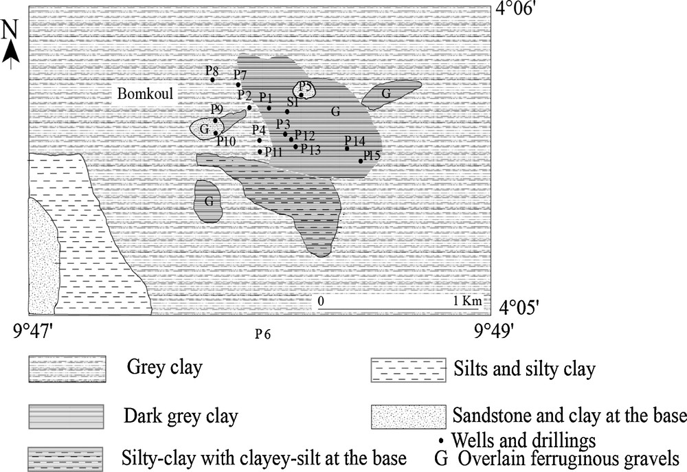
Geological sketch map of the Bomkoul region.
Carte géologique de la région de Bomkoul.
Descriptions des faciès des profils représentatifs de Bomkoul.
| Facies code | Descriptions | Colour | Sedimentary structures |
| S1 | Medium- to coarse-grained sandstones 30 cm to 2 m of thickness | 5Y7/6 to 5R4/6 to 8/1 | |
| S2 | Fine- to medium-grained sandstones alternated layers (1–4 m thickness) | 5R4/6 to 5R5/4 | |
| S3 | Sandy clay (2 m of thickness) | 5R5/4 | |
| F12 | Clayey gravel and fragments of sandstones layer (10–20 cm of thickness) | 5R4/6 | |
| F11 | Nodular clay layers with moulds of gastropods and bivalves (1–2 m of thickness) | 5R4/6 | |
| F10 | Silts with bioclasts of gastropods and bivalves (4 m of thickness) | 5GY4/1 | Laminations |
| F9 | Clayey silt with moulds of gastropods and bivalves (2 m of thickness) | 5GY4/1 | Laminations |
| F8 | Nodular clay layers (2 to 3 m thickness) | 5R5/4 to 5Y7/6 | |
| F7 | Clayey silt with muscovite, fragments of coal, moulds of gastropods and bivalves (6 m of thickness) | 5G4/1 | Laminations |
| F6 | Silty-clay with muscovite, coal, moulds of gastropods and bivalves (4 m of thickness) | 5G6/1 | Laminations |
| F5 | Clay with spots and plates, and some ferruginous nodules (2–4 m of thickness) | 5R4/6 | Laminations |
| F4 | Clay with muscovite and scattered moulds of gastropods; plates and thin slice of the duricrust (6 m of thickness) | 5G6/1 | Laminations |
| F3 | Silty-clay with spots and plates; some ferruginous nodules (4 m of thickness) | 5Y6/1 | Laminations |
| F2 | Clay with moulds of gastropods and coal (4 m thickness) | 5G6/1 | Laminations |
| F1 | Compact clay with muscovite and some fragments of coal (4–6 m of thickness) | 5G6/1 | Laminations |
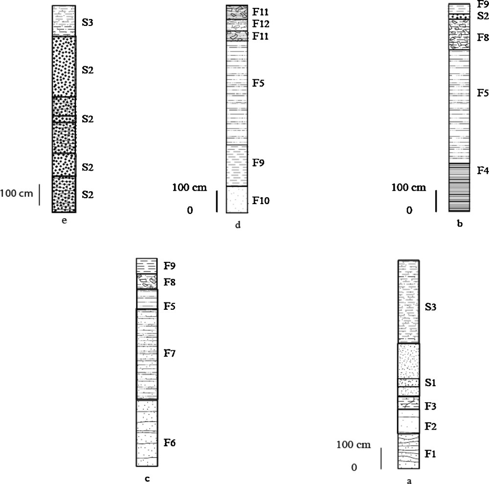
Morphology of the Bomkoul clayey material: a: profile at the upper slope (P9); b and c: profiles at the middle slopes (P4 and P13); d and e: profiles at the lower slope (P3 and P6); S1: medium- to coarse-grained sandstones; S2: fine- to medium-grained sandstones; S3: sandy-clay; F12: clayey gravel and fragments of sandstones; F11: nodular clay; F10: silts; F9: clayey-silt; F8: nodular clay; F7: dark grey clayey-silt; F6: dark grey silty-clay; F5: mottled clay; F4: grey clay; F3: grey silty-clay; F2: grey laminated clay; F1: compact grey clay.
Morphologie des matériaux argileux de Bomkoul : a : profil de haut de pente (P9) ; b et c : profils de mi-pente (P4 et P13) ; d et e : profils de bas de pente (P3 et P6) ; S1 : grès moyen et grossier ; S2 : grès fin et grossier ; S3 : argiles sableuses ; F12 : gravier argileux et fragments de grès ; F11 : argile nodulaire ; F10 : silts ; F9 : silt argileux ; F8 : argile nodulaire ; F7 : silt argileux gris sombre; F6 : argile silteuse gris sombre ; F5 : argile bariolée ; F4 : argile grise ; F3 : argile silteuse grise ; F2 : argile grise laminée ; F1 : argile grise compacte.
5.1.1 The profile at the upper slope
The upper slope profile (60 to 80 m of altitude) with 20 m depth shows from bottom to top, (1) compact grey (5G6/1) clay (F1, Table 2) with muscovite and some fragments of coal (Fig. 3a). It is followed by (2) a 4 m thick bed of grey (5G6/1) laminated clay (F2, Table 2) overlain by (3) a 3 m thick bed of yellow (5Y6/1) laminated silty-clay (F3, Table 2) containing reddish spots centimetre in diameter and ferruginous nodules. However towards the top of the layer, clay becomes rich in sand at, near the contact with sandstones, the 4 m thick alternation of brownish, reddish and yellowish (5R 4/6 to 8/1) medium-to coarse-grained sandstones (S1, Table 2), (4) the upper brownish sandy-clay is the thickest on the top of the inter-fluve (7 m) and the thinnest (0.5 m) or disappears completely along the slope.
5.1.2 The profiles at the middle slopes
The middle slope profiles (40 to 60 m of altitude) are characterized from bottom to top by the weathered, mottled, nodular and sandy-clay layers. They show that weathering moved up from the base of the profiles (Fig. 3b and c). Variations are locally observed. Two clay types with about 10 m depth were identified at the base of the profiles and were overlain by weathered clays: (1) in the middle of the eastern slope of the inter-fluve, in the same profile where the upper slope is localized, the grey (5G6/1) laminated clay (F4, Table 2) with muscovite and scattered moulds of gastropods presents some yellow plates and thin slice of duricrust in the upper part of the layer (Fig. 3b). It is relatively similar with the clay layers of the profile at the upper slope (Fig. 3a), and is followed upward by the reddish (5R4/6) laminated clay (F5, Table 2) with abundant yellowish, reddish, and greyish spots of millimeter to centimeter of diameter, and some ferruginous nodules; (2) in the middle of the western slope of the opposite inter-fluve (P13, Fig. 2), the dark-grey (5G6/1) laminated silty-clay (F6) with muscovite, coal and moulds of gastropods and bivalves is followed upwards by 6 m thick bed of dark grey (5G4/1) laminated clayey silt (F7, Table 2), which is crumbly and also contains abundant muscovite, fragments of coal and moulds of gastropods and bivalves (Fig. 3c). Farther up in the profile, this bed becomes yellow in color and also contains reddish and greyish spots millimeter to centimeter in diameter, and ferruginous nodules. On the top of both middle slope profiles (40 to 60 m of altitude), ferruginous nodules and fine quartz gravels embedded in a clay matrix become abundant in the overlying reddish or yellow brown (5R5/4, 5Y7/6) nodular clay layers (F8 and F9), which can be fitted within thin brownish sandstone (Fig. 3b).
5.1.3 The profiles at the lower slopes
The lower slope profiles (20 to 40 m of altitude) are characterized by their topographic locations. Two types of profiles were identified: (1) the base of the silty and clayey profiles (30 to 40 m of altitude) is dark grey (5GY4/1) silt (F10, Table 2) with whitish fragments of gastropods and bivalves (Fig. 3d) which becomes clayey at the top where fossils were replaced by mouldings. Upwards in the profile (Fig. 3d), silts are followed by a 6 m thick F9 facies. On the top of the profile, characters of the middle slopes were observed (Fig. 3c) where facies F5 is followed by 2 m thick reddish (5R4/6) nodular clay layers (2 m) (F11, Table 2). The following layers can also be fitted by thin (0.5 m) reddish clayey gravels and fragments of sandstones layer (F12, Table 2); (2) the sandstones profile (20 to 40 m of altitude) was observed towards the valley. It presents an alternation of reddish and yellowish fine to medium-grained sandstones (S2, Table 2) which are overlain by thin (0.5 m of thickness) reddish (5R/4/6) strengthened sandstone and reddish (5R5/4) sandy-clay (S3, Table 2) level (Fig. 3e).
5.2 Mineralogy of the clayey raw material
X-ray diffraction patterns indicate that clayey materials of the Bomkoul area are essentially kaolinitic and accessory smectite (Fig. 4). These clay minerals identified by Njopwouo and Wandji (1985) and Njopwouo and Kong (1986) in Bomkoul clay deposit are associated with quartz and goethite as major phases while calcite, ilmenite, muscovite, K-feldspar, hematite and locally gypsum, pyrite, chlorites, and corundum are accessory minerals (Table 3). Gypsum is absent in dark grey clay profiles from the middle and lower slopes while pyrite and corundum are absent in grey clay profiles. A SEM observation was performed on samples of grey, dark grey, mottled, with silty-clay, clayey-silt and clay texture. In grey clayey material, piles of disordered kaolinite were observed where needles of gypsums clearly appear and seem to grow along different directions (Fig. 5a). Also, globular quartz of about 100 μm in size appears in smectite matrix (Fig. 5b) while in dark grey clayey material, fine pyrite cubic crystals (2–10 μm) are embedded in smectite matrix (Fig. 5c). Iron oxides pellicules developed on kaolinite surfaces in mottled clayey material (Fig. 5d). Kaolinites of sedimentary clayey material of Bomkoul area are mainly poorly crystallized (Carty, 1999).
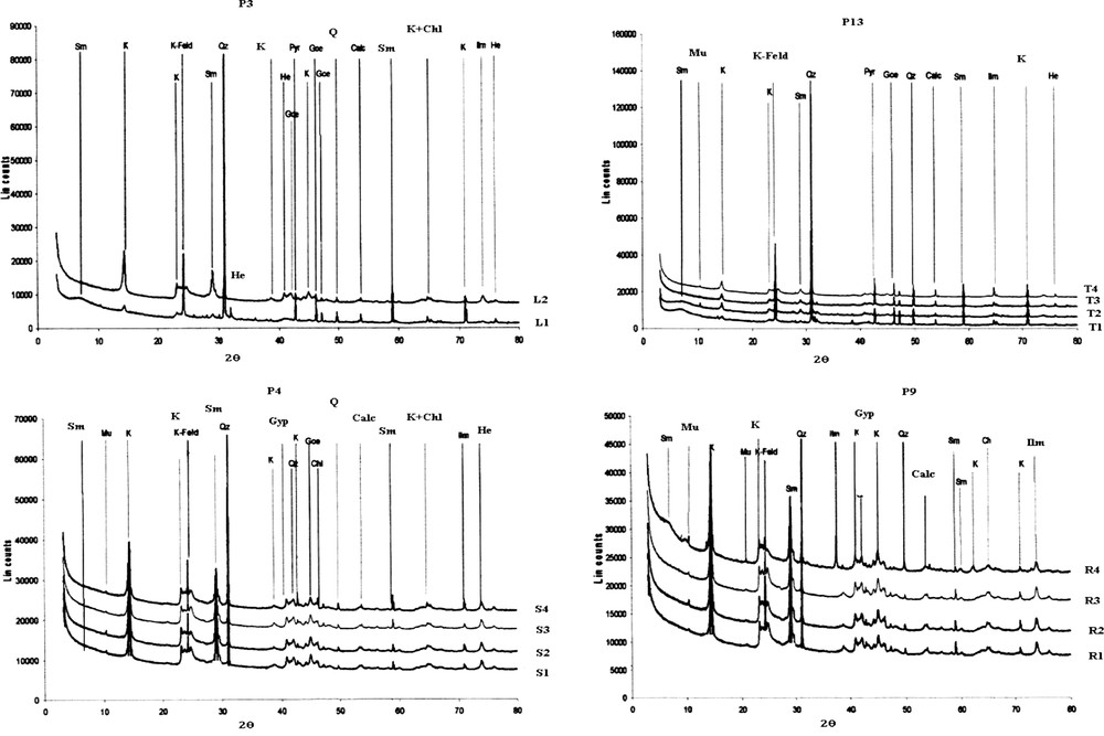
X-ray diffraction patterns of clayey material of the profiles at the upper slope (P9), middle slope (P4 and P13) and lower slope (P3); L1: dark grey silt; L2: dark grey clayey-silt; T1: dark grey silty-clay; T2: dark grey clayey-silt; T3: mottled clay; T4: mottled nodular clay; S1: grey clay; S2: grey silty-clay; S3: mottled clay; S4: mottled clay; R1: compact grey clay; R2: grey clay; R3: grey silty-clay; R4: mottled clay; K: kaolinite; Sm: smectite; Q: quartz; Goe: goethite; Calc: calcite; Mu: muscovite; Pyr: pyrite; Gyp: gypsum; He: hematite; K-Fld: K-feldspar; Ilm: ilmenite; Chl: chlorite; Cor: corundum.
Diagrammes de diffraction de rayons X de matériaux argileux des profils de haut de pente (P9), mi-pente (P4 et P13) et bas de pente (P13) ; L1 : silt gris sombre ; L2 : silt argileux gris sombre ; T1 : argile silteuse gris sombre ; T2 : silt argileux gris sombre ; T3 : argile bariolée ; T4 : argile nodulaire bariolée ; S1 : argile grise ; S2 : argile silteuse grise ; S3 : argile bariolée ; S4 : argile bariolée ; R1 : argile grise compacte ; R2 : argile grise ; R3 : argile silteuse grise ; R4 : argile bariolée ; K : kaolinite ; Sm : smectite ; Q : quartz ; Goe : goethite ; Calc : calcite ; Mu : muscovite ; Pyr : pyrite ; Gyp : gypse ; He : hématite ; K-Fld : feldspath-K ; Ilm : ilménite ; Chl : chlorite ; Cor : corindon.
Compositions minéralogiques des matériaux argileux des profils représentatifs de Bomkoul : Kao : kaolinite ; Sm : smectite ; Qz : quartz ; Goe : goethite ; Calc : calcite ; Mu : muscovite ; Pyr : pyrite ; Gyp : gypse ; He : hématite ; K-Fld : feldspath-K ; Ilm : ilménite ; Chl : chlorite ; Cor : corindon.
| Profile | Depth | Colour | Mineralogical composition (%wt) | ||||||||||||
| (cm) | Kao | Sm | Qz | Goe | Calc | Mu | Pyr | Gyp | He | K-Fld | Ilm | Chl | Cor | ||
| P3 profile (lower slope) |
|||||||||||||||
| L2 | 660 | Dark grey | 27.0 | 21.6 | 13.5 | 10.8 | 5.4 | 2.7 | 5.4 | – | 5.4 | 5.4 | 2.7 | 2.7 | 1.3 |
| L1 | 800 | Dark grey | 35.1 | 21.6 | 8.1 | 8.1 | 5.4 | – | – | – | 2.7 | 5.4 | 8.1 | 5.4 | 1.3 |
| P4 profile (middle slope) |
|||||||||||||||
| S4 | 185 | Mottled | 36.5 | 19.5 | 12.2 | 7.3 | 4.8 | 2.4 | – | 4.8 | 2.4 | 4.8 | 4.8 | 2.4 | – |
| S3 | 285 | Mottled | 35.5 | 16.3 | 11.7 | 6.6 | 4.4 | 2.2 | – | 4.4 | 2.2 | 4.4 | 6.6 | 2.3 | – |
| S2 | 640 | Grey | 32.5 | 18.6 | 13.9 | 6.9 | 4.6 | 2.3 | – | 4.6 | 2.3 | 2.3 | 6.9 | 2.3 | – |
| S1 | 1100 | Grey | 32.0 | 16.0 | 16.0 | 6.0 | 6.0 | 2.0 | – | 4.0 | 2.0 | 4.0 | 6.0 | 6.0 | – |
| P9 profile (upper slope) |
|||||||||||||||
| R4 | 1125 | Mottled | 36.7 | 14.2 | 12.2 | 8.1 | 6.1 | 2.0 | – | 4.1 | 2.1 | 4.0 | 6.0 | 6.0 | – |
| R3 | 1325 | Grey | 39.6 | 14.5 | 12.5 | 6.5 | 6.5 | 4.1 | – | 4.1 | 2.1 | 4.1 | 6.5 | 4.1 | – |
| R2 | 1700 | Grey | 38.0 | 11.5 | 17.3 | 5.7 | 5.7 | 3.8 | – | 3.8 | 1.9 | 3.8 | 5.7 | 3.8 | – |
| R1 | 1900 | Grey | 37.2 | 15.6 | 15.6 | 7.8 | 7.8 | 3.9 | – | 3.9 | – | 3.9 | 5.8 | 3.9 | – |
| P13 profile (middle slope) |
|||||||||||||||
| T4 | 110 | Mottled | 33.3 | 15.2 | 12.1 | 9.1 | 6.1 | 3.0 | 6.0 | – | 3.0 | 6.1 | 3.0 | 3.0 | – |
| T3 | 285 | Mottled | 31.0 | 13.8 | 13.8 | 10.3 | 6.8 | – | 6.8 | – | 3.4 | 6.8 | 3.4 | 3.4 | – |
| T2 | 460 | Dark grey | 25.0 | 18.7 | 12.5 | 12.5 | 6.2 | 3.1 | 6.2 | – | 3.1 | 6.2 | 3.1 | 3.1 | – |
| T1 | 780 | Dark grey | 31.3 | 15.6 | 12.5 | 12.5 | 6.2 | – | 6.2 | – | 3.1 | 6.2 | 3.1 | 3.1 | – |
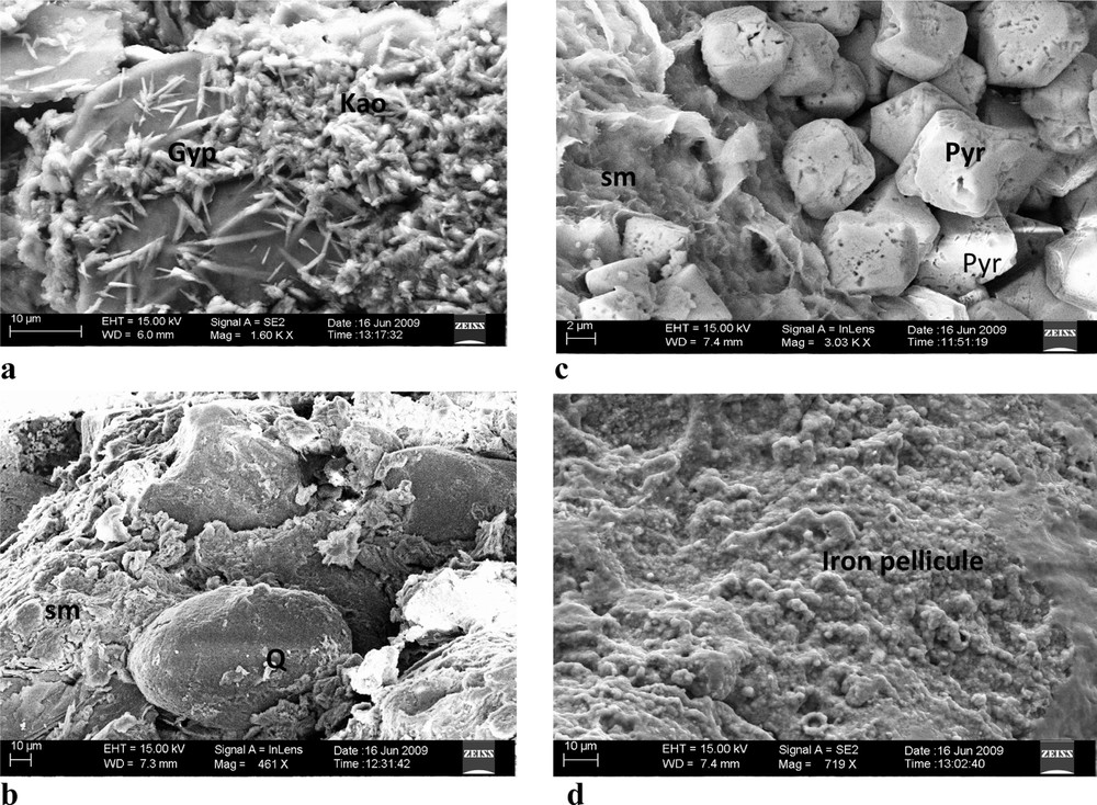
SEM images of the Bomkoul clayey material: a: grey clay; b: grey silty-clay; c: dark grey clay; d: mottled clay; Kao: kaolinite; Gyp: gypsum; Sm: smectite; Q: quartz; Pyr: pyrite.
Images MEB des matériaux argileux de Bomkoul : a : argile grise ; b : argile silteuse grise ; c : argile gris sombre ; d : argile bariolée ; Kao : kaolinite ; Gyp : gypse ; Sm : smectite ; Q : quartz ; Pyr : pyrite.
5.3 Geochemistry of the clayey raw material
Geochemical composition (major and some trace elements) shows that clayey materials of the Bomkoul area are siliceous and aluminous with small iron content and bases (MgO, CaO, Na2O, K2O) content (Table 4). The profiles with dark grey clayey material overlain by mottled clays (P3 and P13) are more siliceous than the profiles with grey clayey material (P4 and P9) (48.81–69.97% SiO2 against 38.56–53.34% SiO2 respectively). In addition dark grey alumina content is smaller and more variable in relation with the topographic position than that of the profiles with grey clayey material, which are more homogeneous in alumina content.
Éléments majeurs des matériaux argileux des profils représentatifs de Bomkoul (%wt des oxydes).
| Depth | SiO2 | Al2O3 | Fe2O3 | MgO | CaO | Na2O | K2O | TiO2 | P2O5 | MnO | Cr2O3 | LOI | Total | |
| MDL | (cm) | 0.01 | 0.01 | 0.04 | 0.01 | 0.01 | 0.01 | 0.01 | 0.01 | 0.01 | 0.01 | 0.002 | ||
| P3 profile | ||||||||||||||
| L4 | 160 | 47.46 | 26.22 | 9.89 | 0.14 | 0.02 | 0.02 | 0.21 | 1.88 | 0.08 | 0.01 | 0.018 | 13.9 | 99.85 |
| L3 | 470 | 51.88 | 25.29 | 6.97 | 0.15 | 0.03 | 0.02 | 0.19 | 1.94 | 0.08 | 0.02 | 0.017 | 13.3 | 99.86 |
| L2 | 660 | 67.02 | 10.87 | 4.33 | 0.60 | 0.05 | 0.20 | 1.56 | 1.78 | 0.07 | 0.02 | 0.017 | 13.2 | 99.67 |
| L1 | 800 | 48.81 | 16.65 | 6.42 | 1.62 | 0.10 | 0.25 | 1.38 | 1.56 | 0.16 | 0.04 | 0.021 | 22.8 | 99.79 |
| P4 profile | ||||||||||||||
| S4 | 185 | 43.52 | 31.02 | 8.64 | 0.10 | < 0.01 | 0.02 | 0.24 | 2.02 | 0.10 | 0.01 | 0.021 | 14.2 | 99.85 |
| S3 | 285 | 38.56 | 28.41 | 16.09 | 0.08 | < 0.01 | 0.01 | 0.18 | 1.60 | 0.13 | 0.02 | 0.020 | 14.7 | 99.85 |
| S2 | 640 | 42.44 | 30.61 | 9.60 | 0.14 | < 0.01 | 0.01 | 0.25 | 1.84 | 0.11 | 0.01 | 0.021 | 14.8 | 99.85 |
| S1 | 1100 | 40.97 | 26.10 | 10.75 | 1.29 | 0.37 | 0.05 | 0.67 | 1.44 | 0.11 | 0.13 | 0.016 | 17.9 | 99.83 |
| P9 profile | ||||||||||||||
| R4 | 1125 | 49.89 | 30.38 | 2.57 | 0.15 | 0.01 | 0.06 | 0.75 | 1.87 | 0.06 | < 0.01 | 0.018 | 14.1 | 99.83 |
| R3 | 1325 | 53.34 | 29.35 | 1.96 | 0.17 | 0.01 | 0.06 | 0.86 | 2.05 | 0.07 | < 0.01 | 0.017 | 11.8 | 99.75 |
| R2 | 1700 | 39.52 | 26.39 | 13.07 | 1.04 | 0.35 | 0.04 | 0.78 | 1.50 | 0.11 | 0.12 | 0.018 | 16.9 | 99.83 |
| R1 | 1900 | 44.68 | 26.27 | 9.33 | 1.21 | 0.34 | 0.07 | 1.36 | 1.60 | 0.10 | 0.10 | 0.019 | 14.7 | 99.78 |
| P13 profile | ||||||||||||||
| T4 | 110 | 66.44 | 13.57 | 7.97 | 0.17 | < 0.01 | 0.01 | 0.17 | 1.75 | 0.06 | 0.01 | 0.018 | 9.6 | 99.79 |
| T3 | 285 | 69.97 | 11.07 | 7.67 | 0.25 | < 0.01 | 0.04 | 0.58 | 1.88 | 0.05 | 0.01 | 0.015 | 8.3 | 99.82 |
| T2 | 460 | 59.09 | 14.64 | 4.46 | 0.56 | 0.03 | 0.22 | 1.64 | 1.64 | 0.07 | 0.01 | 0.015 | 17.4 | 99.81 |
| T1 | 780 | 64.39 | 8.49 | 8.23 | 0.99 | 0.24 | 0.17 | 1.71 | 1.95 | 0.08 | 0.03 | 0.020 | 13.3 | 99.55 |
6 Discussion
In the study area, different types of sediments (sandstones, silts, clays, and mixed facies: silty-clay, clayey-silt, sandy-clay and nodular clay) were observed in the Douala sub-basin (Belmonte, 1966; Nguene et al., 1992; Njike Ngaha, 1984). Bomkoul clayey material rich in moulds of gastropods and bivalves are mainly of sedimentary origin because they result from deposition due to suspension, low energy deposits with possible high velocity currents or waning flood in continental to coastal environments. However, only laminations have been described in terms of sedimentary structures.
Clayey material appears very variable in their color, texture, and thickness: they display grey, dark grey or mottled colors, with silty-clay, clayey-silt and clay textures. The same characteristics have been recognized in another area of the Douala sub-basin: Maurizot (1986, Banga and Ekiti), Thibaut and Le Berre (1984, Bonangando and Kwa Kwa), Samba (2010, Missole). The thickness of clayey material depends on the geomorphology/sedimentation couple: they are the thickest in the upper slopes where clay layers are protected by the overlying sandstones and the thinnest in the middle and the lower slopes where denudation is the dominant process.
Weathered clayey products are the thickest and are characterized by the mottled clayey material in middle and lower slopes, whereas nodular and sandy-clay layers appear on the top of the profiles. Laterite cover widely developed in the humid tropical region of South Cameroon from Tertiary to recent times as a result of weathering process which took place when humid conditions fostered vegetation growth (Tardy, 1993). Cojan and Renard (1999) described the weathering process in sedimentary domains where soil formation process disturbed sedimentary structures, and iron products formed ferruginous nodules or ferricrete. In such humid conditions, goethite is the main iron mineral. Indeed, goethite crystallized in tropical environment by hydration of hematite or oxidation of pyrite (Reineck and Singh, 1980; Tucker, 2001).
Bomkoul clayey materials contain in decreasing order kaolinite, smectite, quartz, goethite and calcite, with their crystallized gypsum in the grey clayey material, and pyrite in the dark grey clayey material. The clay sediments show conditions of reduced or restricted environment such as in a floodplain, a bay, or a coastal plain environment. The presence of moulds or shells of gastropods and bivalves indicates marine conditions. Berner (1984) showed that pyrite develops in marine deposits by bacterial reduction of sulphates when redox conditions are the highest. The presence of pyrite and gypsum in sedimentary clays has been described in many deposits of the Douala sub-basin and other basins such as PK27, locality of the Douala region (Abomo, 2010; Bomkoul, Njopwouo and Kong, 1986) or South-East Nigeria (Aribisala and Agdegbesam, 1994).
Organic matter (OM), pH, carbon and nitrogen contents reflect field characteristics and depend on the clayey material nature and the topographic position of the profile. OM contents of the Bomkoul clayey material are generally, i.e., less than 4% (Metson, 1961). The highest content is observed in dark grey clayey material of the middle and lower slopes, and the lowest in mottled and grey clayey material of the upper slopes. Moreover, the presence of carbon and nitrogen, and acidity of clayey material follow the same dynamic. Also, particle size reveals texture classes in accordance with some field characteristics such as smoothness, stickiness and plasticity (Fitzpatrick, 1983): clay, silty-clay, clayey-silt and sandy-clay textures characterize very sticky and plastic materials. Indeed, the fine particles and especially the very fine clay minerals determine the plasticity of an earthly material (Aliprandi, 1979; Jouenne, 1990). The type of clay mineral can have an effect since some clay (e.g. montmorillonite) absorbs more water than other (e.g. kaolinite). The main clay minerals in grey, dark grey and mottled clayey materials are kaolinite and minor smectite probably montmorillonite (Njopwouo and Kong, 1986) thus the plasticity of clayey materials is due to the highest amount of clay mineral. However, high contents of some accessory minerals in clay materials can have negative effect in clay applications like iron or sulfur rich minerals. Some dark grey clay materials of the Bomkoul area with high pyrite contents may not be efficiently used for ceramic manufacture.
Bomkoul clayey materials are also characterized by their variable alumina content, and iron with low or high amount in the dark grey and grey clayey materials and high amount in the mottled clayey material. Variable alumina content and high or low amount of iron content in the dark grey and grey clayey materials situated on the base of profiles, and high alumina and iron contents in the mottled clayey material situated on the top of profiles show that weathering is concentrated with Al and Fe in the mottled clayey material. In fact, as mentioned by Bloodworth et al. (1993), Castelein (2000) and Ngon Ngon et al. (2009), the alumina and iron contents of a sample are an important factor. Clay for some ceramic products (pottery, earthenware, brick, tile, porcelain), A low alumina content (< 35%) is necessary to obtain fine product and for kaolin, A low iron content (< 0.9%) in kaolin is necessary in order to achieve fired brightness values. The Bomkoul clayey materials essentially have good alumina content for some ceramic products and are rich in iron (with more than 1% Fe2O3).
7 Conclusion
The Bomkoul clayey raw materials are characterized by three clay facies (mottled, grey and dark grey clayey materials) with fine particles (clay, silty-clay, clayey-silt and sandy-clay textures) and dominated by silica, alumina and iron. Although mineral proportions may vary between the three clay facies, the general mineralogy is made up of kaolinite, smectite, quartz, goethite and calcite, with local presence of gypsum and pyrite respectively in the grey and dark grey clayey materials. With their grain size, alumina lower than 35% Al2O3, and silica lower than 60% SiO2 for the major raw materials, the Bomkoul clayey materials are suitable for the manufactured of bricks, tiles, soil sandstones. But clayey material (with iron content more than 10% Fe2O3) may not be efficiently used for ceramic manufacture.
Acknowledgements
The authors are grateful to the staff of the Institut de recherches pour le développement (IRD), France, for microscopic and mineralogical analysis and the staff of AcmeLabs Analytical Laboratories, Vancouver, Canada for chemical analysis.