

1 Introduction
The western coast of Africa has been strongly influenced by the deposition of sediments such as sandbars and deltas during and since the last glaciation. Sandy beaches dominate much of the coastline; behind them, extensive lagoon systems are sometimes found. Such sandy beaches are constantly changing their profiles due to either beach erosion or sand accumulation. The tidal range is 2.1 to 3.4 m. The strong swells come from the southwest to the northwest and can reach 7 to 9 m.
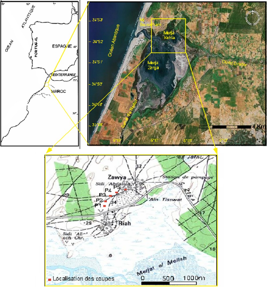
The Moulay Bouselham lagoon (34°47′N–6°13′W and 34°52′N–6°14′W) is located on the Atlantic Ocean coast of Morocco (Fig. 1) about 120 km north of the town of Rabat. This lagoon is a wetland of 7000 ha, adjacent to a small coastal town that serves as a centre of attraction for domestic and regional tourism. It consists of a large coastal lagoon [2] with extensive intertidal mudflats, subtidal seagrass, and fringing marshes, and it can be considered a coastal wetland. This lagoon is 11.9 km long, 6.5 km wide on average, and exchanges water with the ocean through a major inlet about 360 m wide. This basin reflects the morphology of a depression, in a north–south direction, limited by a continental cliff and by a coastal consolidated dune ridge. The Drader River channel divides the lagoon into two sub-basins, Merja1 Khala to the north, with an average depth of 0.3–0.5 m, and Merja Zerga to the south, with an average depth of 1–1.5 m depth. The outer channels are 4–5 m deep.
2 Geological and structural context
The Atlantic coast of Morocco is composed of a succession of rocky shores and low, sandy shorelines interrupted by estuarine and lagoonal inlets. The Moulay Bouselham lagoon is located in the northern part of the Gharb plain [5]. This subsiding basin has accumulated a large amount of sediments brought down by the Sebou and Ouerrha Rivers from the Rif and Middle Atlas mountains (Fig. 2). This basin was filled with sediments of marine origin (marls and sands) during the Tertiary and with continental formations during the Quaternary, except for a coastal fringe [4,16]. This basin presents an important subsidence, which lasted until the historical age [16], and it is clearly located inside the South Rifian front [3], recognized in seismic survey a few kilometres to the north of the Kenitra town [17].

Simplified structural sketch of northwestern Morocco (after [3]).
Fig. 2. Schéma structural simplifié du Nord-Ouest marocain (d’après [3]).
In the Moulay Bouselham zone, the Mesetian domain shows a tabular Meso-Cenozoic cover, not very thick, resting on a Palaeozoic base with a moderately folded and faulted zone with subvertical schistosity, constituting the coastal Mesetian Mole [18]. The strongly folded and granitized Palaeozoic series corresponds to a Caledonian–Hercynian ditch filled with Dinantian flyschs [20].
In this zone, the thick detritus deposits accumulated since the Miocene have undergone tectonic deformations during the Pleistocene, which results in a succession of domes and basins. We can distinguish two great structural directions: (i) a Villafranchian meridian flexure, in the East of the lagoon; (ii) an east–west anticline and syncline structures inherited from post-Villafranchian tectonics.
The lagoon is limited to the south by the Quaternary anticline structure of Lalla Zohra, which shows an east–west direction and culminates at 100 m high. It isolates the gutter of Moulay Bouselham from the remainder of the subsident Rharb basin, through the basin of Lalla Mimouna in the east, through the heights of the Khlot country in the North and northeast, subzone of the western High-Rharb, and finally, through an alignment of Quaternary consolidated dunes through the west, present throughout the plain of Rharb (the Sahel). In this dune unit, four series were identified [18] from the Middle Quaternary to the present day. The dune series that are juxtaposed everywhere else in Rharb are stepped in the My Bouselham sector.
The lagoon's morphology (Fig. 1), with its much reduced northern diverticulum (Merja Khala),and, moreover, the linearity of the Drader wadi suggest the existence of an east–west important accident along the downstream course of this river. Such a structural lineament is easily observable on satellite imagery (Fig. 1) and the important reduction in the dimensions of the lagoon to the north of this feature suggests (1) the presence of a first-order accident, and (2) the rise of the northern compartment.
The seismic activity recorded in the area attests to the continuous subsidence of this flattened area and makes it possible to individualize the behaviour of a satellite basin compared to the large basin of Rharb [5]. Geophysical data allowed us to show that the east–west Lalla Zahra ridge is the result of a ‘Toe Thrust’ in relation with the activation of the Rifian arc [10,25]. The My Bouselham region is situated in an area where we can observe an important change in the direction of the tectonic structures (north–south in offshore, east–west on land) [10,18]. This is the result of the north–south post-Pliocene to Quaternary compressive movement. All these characters confer to this area the quality of an important tectonic knot. This area remains seismically less active than the Rif or the High Atlas mountains, but undergoes regularly counters, then rebounds of earth tremor, whose epicentres are located sometimes at a very short distance. The last important seismic event in the area took place on 28 June 2001, with a magnitude of 5.2° on the Richter scale (its epicentre was at a latitude of 34.37° north and a longitude of 6.57° west).
3 Lagoon lifted deposits observations
We note the presence of five outcrops of deposits with an average thickness of 15 cm (Fig. 3) in an old sandstones quarry (Zawya quarry, Fig. 1), located at approximately 1400 m to the north of the northern end of the Merja Khala. These continuous dark colour levels are muddy, and include many vegetation fragments. They are positioned (Fig. 3) at altitudes varying between +24 and +32 m, and the studied profiles show that they top gritty dune calcareous sandstone. Within these, we can observe dissolution wells more than one meter deep and 20 to 30 cm in diameter. Several hypotheses were proposed to explain their presence. We think that they are probably related to old plant trunks (palm trees…), which could have favoured the dissolution processes of carbonates [19]. These lagoonal levels are covered by 10 to 15 cm of recent ‘beige soils’, while locally they rest on ‘Mediterranean red soils’ of Soltanian age (120 000 to 20 000 BP). This position confirms that their situation cannot be allotted to an unspecified human activity and that these levels are well in place.

North–south profile and details of each outcrop of lagoonal deposits.
Fig. 3. Profil nord–sud et détails des affleurements des dépôts lagunaires.
In addition, the dune sandstones shows a general slope within their stratification deposits of ten degrees towards the north, while sub plane–vertical discontinuities directed N 110° are sometimes underlined by the presence of tectonic breccias (Fig. 4), suggesting the occurrence of faults with the same direction as the Drader's fault.

3D representation of levels P1, P2 and P3, and fault system.
Fig. 4. Représentation 3D des niveaux P1, P2 et P3, ainsi que des accidents.
A grain size analysis indicates that the first two outcrops (P1 and P2) are sandy clays and the three others (P3, P4, and P5) are silty clays. These levels are rich in shelly remains and whole shells (Cardium, Cerastoderma edule), indicating a lagoonal environment.
The micro-fossiliferous contents of the P1 level show, obviously, that it is indeed a deposit of lagoonal origin with Elphidia, Ammonia, Hydrobia, and ostracodes such as Ciprideis gr. torosa and Loxoconcha elliptica. The sediments kept the imprint of a littoral environment with worn and rolled elements, witness of a higher dynamics than at present, and rare little rolled and in place ostracodes, typical of a lagoonal environment.
The P3 level shows the existence of more or less fragmented lamellibranches shells (Cerastoderma, Arca) and the presence of Ammonia tepida, indicating a euryhaline environment. The associations of ostracodes (the same ones as in the P1 level) and rare Aurica convexa are typically lagoonal species and indicate strong variations of salinity without freshwater species.
Carbon-14 dating was carried out at the Laboratory of Radioanalyses and Environment (LARAE) of the School of Engineers of Sfax (Tunisia). The values obtained on the P3 profile give an age of 2400 ± 250 BP. Ancient ages’ measurements were carried out in a core taken in Merja Khala [2], in which two levels of shelly deposits were identified. The first (between 30–35-cm depth in the core) gave a radiogenic 14C age of 2170 ± 210 BP (LY 2633), and the second, more ancient, gave an age of 3490 ± 100 BP (LY 4542). The fauna observed in these levels is absolutely comparable to the one analysed in the five outcrops of the quarry.
4 Discussion
The possible origin of the outcrop of the laguna's level observed at an altitude ranging between +24 and +32 m can be multiple and varied. In the current state of our knowledge, four origins can be considered for the installation of these deposits: (i) control by hydrodynamic phenomena particularly spectacular and able to bring to a certain altitude deposits close to the sea level, namely storms or tsunamis; (ii) important increase of the level of filling of the lagoon in relation to a more or less long closing of its connection with the ocean; (iii) occurrence of Triassic deposits that induce a salt diapirism; (iv) finally, very recent and particularly active tectonics able to rise these deposits originally deposited near the present sea level.
- • Concerning the hydrodynamic assumption, the silty-sandy with argillaceous sandstones nature of the deposits seems to refute this kind of possibility. Tempestites and other tsunamis deposits, connected with tidal waves that could be generated by, for example, the great earthquake of Lisbon in 1755 [13], usually consist of rather coarse and heterogeneous materials. This assumption cannot completely be rejected, even if the altimetry of the deposits seems definitely higher than the height of the tidal wave that followed this seismic episode (estimated to be 10 to 15 m high).
- • The second assumption, articulated around a more or less prolonged isolation of the lagoon compared to the opened ocean, could be justified if the analyzed deposits showed very serious faunistic characters specific of the continental environment. Indeed, the surface covered by the rise of the level of more than 30 m compared to the actual level would correspond to a volume of water of considerable continental origin. However, faunistic associations clearly indicate that we are always in the presence of a typical lagoonal environment. Moreover, it would then be necessary to find the equivalent of these deposits on the circumference of the entire present-day lagoon, which in the current state of our knowledge is not the case. As for the Mellahian episode (local equivalent of Flandrian), neither its age (6000 BP, [18]) nor its amplitude of +2 m compared to the current level can explain such altitudes.
- • The third hypothesis could be in relation with the uplift of Triassic salt induced by a large halokinetic tectonics, such as the one observed near the southern flank of the Lalla Zohra structure. Nevertheless, there is no outcrop of Triassic near and around the lagoon. Moreover, the seismic data of this sector do not show such a salt tectonics.
- • The last possible assumption relates to an excessively activated neotectonics. Indeed, if the dating seems to agree around the values of 2400 ± 250 BP, one must then admit an uplift rate from 12 to 14 mm/yr (?). This date is close to a date obtained by Carruesco [2] on a shelly level from a core taken in Merja Khala (2170 ± 210 yr BP). If these ‘high’ lagoonal levels are to be correlated with the high marine Mellahian level (cf. above), it seems that uplift rates are still a bit high and that we must reconsider the whole assumptions. Indeed, the generally recognized highest uplift rates are about 10 to 14 mm/yr for the Scandinavian shield or the Hudson Bay. Calabria rises at rates practically 10 times lower than those we calculate. Our observations indicate, in addition, that no anthropic intervention can be at the origin of this fact. The levels recognized are in place and are covered by a soil. However, the existence of such movements cannot be denied, their presence having already been confirmed on other sectors of the Moroccan Atlantic northern littoral, like the Tangitan area [1], or the northern Mesetian coast [11]. The morphology of the lagoon results from a very recent uplift of its northern compartment, starting from a sufficiently active and recent accident to be easily detectable (Fig. 1) on all the cartographic, photographic supports, and satellite imageries (SPOT, LANDSAT, among others…) and proved by the recording of the recent earthquakes. This structure should therefore be of first order. In addition, a morphostructural analysis of the continental margin highlighted the existence of a positive topographic anomaly in the continuity of the Drader Wadi in this sector [8].
In this context of very active and recent tectonics, observed, in particular, on seismic profiles taken in the marine domain offshore the lagoon [7], it appears to us that a new assumption can be formulated. Indeed, the recent discovery along the Moroccan Atlantic margin of a vigorous argilokinetic (Fig. 5A and C) tectonics brings new information. The latter would accompany the development of a tectonic accretionary prism, in relation to the subduction of the Atlantic oceanic floor under the arc of Gibraltar [13,14]. Several international oceanographic cruises carried out in recent years [6,7,21,22] highlighted the presence of many very active mud volcanoes to the northwest of the lagoon at a distance of about 40 km from the lagoon. The ‘El Arraiche Mud Volcano area’ [7,22,3] shows a remarkable alignment of eight argilokinetic structures (Fig. 5A), whose natural prolongation towards the continental domain coincides quasi perfectly with the area of Khlot Land (Fig. 1), which constitutes the northern border of the lagoon. It would then be necessary to connect the sudden uplift of this sector to the presence of a buried local clay increase. In fact, the most active and youngest mud dome is the Al Idrissi mud volcano [22], which (Fig. 5) is 225 m, high, up to 5.4 km wide at its base and 1.5 km wide its top. Its activity is the result of the regional stresses.
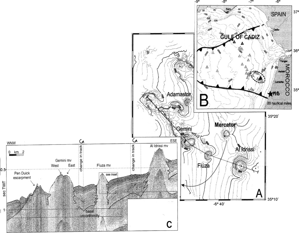
Relationship between lagoon, geodynamic frame and argilokinetic structures. A. Map of the El Arraiche mud volcano field (after [23]). B. Map of the Gulf of Cadiz and of the Moroccan Margin (after [23]). White triangles represent mud volcanoes. The line of black triangles represents the deformation front of the accretionary prism (after [13]). MB: Moulay Bouselham (black star). C. High-resolution seismic line over the El Arraiche field (after [23]).
Fig. 5. Relations entre la lagune, le cadre géodynamique et les structures argilocinétiques. A. Cartographie du secteur du volcan de boue El Arraïche (d’après [23]). B. Carte du golfe de Cadix et de la Marge marocaine (d’après [23]). Les triangles blancs représentent les volcans de boue. La ligne de triangles noirs représente le front de déformation du prisme d’accrétion (d’après [13]). MB : Moulay Bouselham (étoile noire). C. Profil sismique haute résolution recoupant le champ El Arraiche (d’après [23]). Masquer
Fig. 5. Relations entre la lagune, le cadre géodynamique et les structures argilocinétiques. A. Cartographie du secteur du volcan de boue El Arraïche (d’après [23]). B. Carte du golfe de Cadix et de la Marge marocaine (d’après [23]). ... Lire la suite
This kind of strong and rapid events is reminiscent of those observed on the southern part of the island of Trinidad [15], or even in Colombia near the town of Cartagena (the ‘Totumo’) [24]. There, a subaerial mud volcano, located near the littoral, constitutes a structure more than 25 m high, and shows that important morphologies can evolve/move in a very fast way. Similar phenomena in the marine domain occur on numerous submarine environments, like the southern part of the Barbados’ accretionary prism [9,11], where these structures have spectacular dimensions (they are several hundreds of meters high, with diameters often exceeding one kilometre). They show, locally, the buried under compacted and water supersaturated in-depth clay level, easily mobilizable. These increases of material from deep in the sediment are supported by overpressures of fluids, which are expressed in the form of benthic vents, being accompanied sometimes by biocoenosis, of early diagenesis processes, even sometimes of carbonated chimneys [6,7,9,12].
We could then suggest that the Moulay Bouselham area is inside the zone of materialized deformation; in addition, the existence, seaward, of a tectonic accretionary prism (Fig. 5B); [14,21], induces a strong argilokinetic activity, accompanied by gravitational slide structures. Structures comparable to these mud volcanoes could be at the origin of the observable deformations in the sector. A part of this assumption could be checked using a high-resolution seismic campaign on land.
5 Conclusion
If our assumption of material coming from greater depth and accompanying vigorous argilokinetic tectonics along the northwestern Moroccan margin proves to be exact, we would then have to admit that the area of the Moulay Bouselham lagoon positions near the southernmost termination of a tectonic active area in the particular context of the accretionary prism (Fig. 5B) relates to the subduction of a part of Atlantic oceanic crust under the African plate. This deformation secondarily involves argilokinetic processes that would control p.p. the structure and the evolution of this lagoonal environment position in a context of recent hyperactive tectonic, corresponding to a rim-syncline structure with a high subsidence rate.
Acknowledgements
This work is supported by a ‘French-Moroccan Integrated Action Program’ (A.I. MA/04/101) and the PROTARS III project D15/06.The authors gratefully acknowledge the reviewers for their helpful comments and corrections, which have enabled us to improve this paper.
1 Merja : local terminology for an area with more or less water, temporary or permanent, which received this water from different origins [16].
Moulay Bouselham lagoon, location and satellite imagery (after Google Earth, 2007).
Fig. 1. La lagune de Moulay Bouselham, localisation et image satellite (d’après Google Earth, 2007).